

-
 9773 Hits
-
 89.39% Score
-
 29 Votes
|
|
Mountain/Rock |
|---|---|
|
|
45.57340°N / 7.08210°E |
|
|
10698 ft / 3261 m |
|
|
Overview
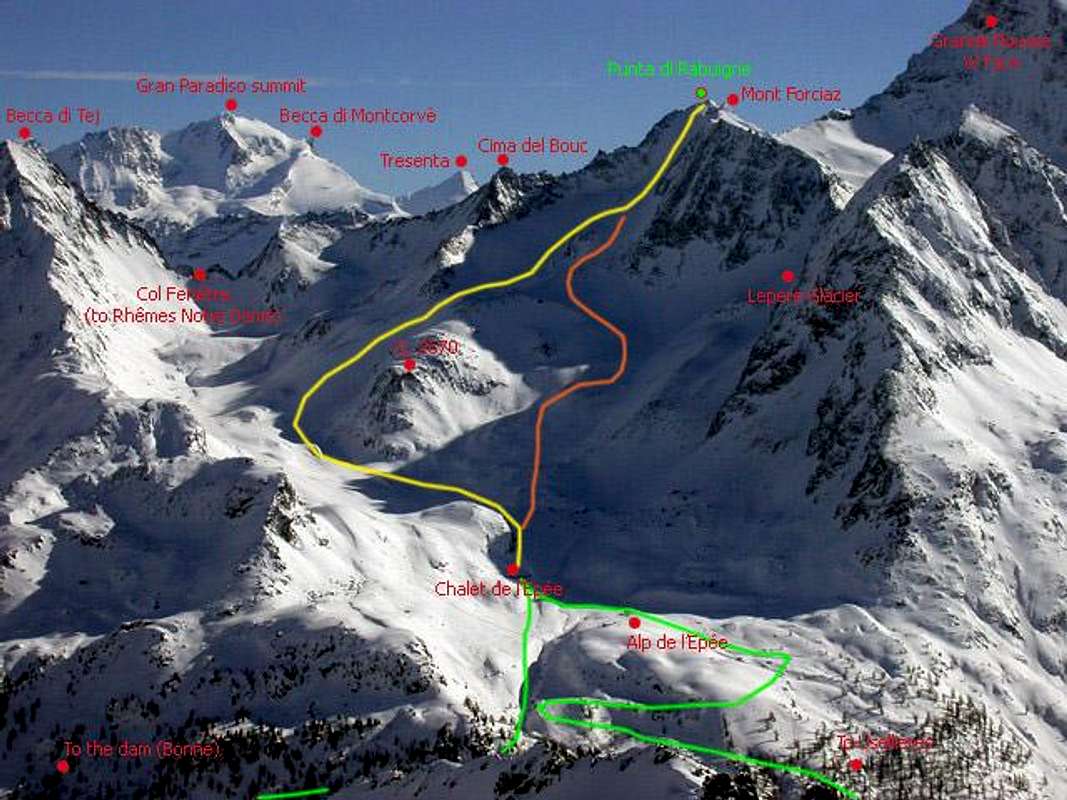
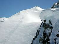
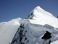
Punta di Rabuigne, seen from Valgrisenche, is a regular ice-snowed capped summit, hidden at the end of wild Vallone del Bouc (Bouc Valley).
As for this steep slope (about 30 deg.), Punta di Rabuigne is one of the most exciting ski-mountaineering descent of all Aostan Valley, where perfect assested snow conditions are required, for a safe hike.
Most of people ascent to Rabuigne summit in springtime with skis, but it is possible to scramble this desolate stoney and ice side in summer: not so usual.
Unfortunately Valgrisenche is affected by heliski. Punta di Rabuigne is a tasty target for this minor (but very noisy) sport.
***
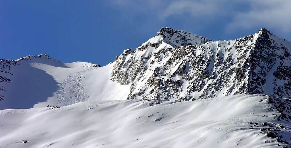
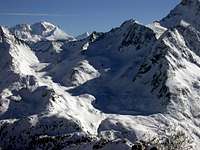
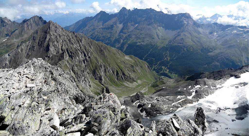
So wrote Buxlex, on the page opened on March 2, 2005 and that here we want to retouch it to partial completion as well as inserting further information from the geological and morphological point of view, expanding the orographic and structural description concerning ridges and walls. An extension of what already highlights enough and summarizes the photo posted by the same in "Overview". A photo that however sums up highlighting only the Northern side of this mountain which, positioned on the North / South axis of the watershed dividing the Valleys of Rhemes in the East and Valgrisenche in the West, precedes the much more important pyramid of the Grande Rousse Nord (3.607m), such as to "weigh" them like a shadow on the shoulders. Furthermore, a short buttress towards the West-northwest is projected, but not detached, from the same; the same form the two summits of Monte Forciaz, which from the Westernmost summit (3.185m) runs out with three ribs facing North-northwest, Northwest (the main) and West respectively. These two last contain in the North the narrowest initial part of the Forciaz Valley, before it widens in the three Forciaz Glaciers (to the north), Invergnan (in the center) and Giasson (to the south), located at the foot of the arched sector including Monte Forciaz, Punta di Rabuigne, the two Summits of the Grande Rousse, followed by the Punta Tina (3.523m), Barmaverin (3.472m) and the Cima di Fos (3.447m), from this "corner stone" the ridge, dividing from the Vallon of San Martino in the South, first bends to the West towards the Becca di Giasson (3.215m) and then to the North-northwest, reaching the tiny Becca Rafreita (2.612m) and thus "closing" the valley in a complete fashion and with circular manner. Still analyzing the structure of the Northern side, it is to be observed how the same is divided into two other parts, as happens for the Bouc Glacier between Punta di Rabuigne and Monte Forciaz which descends with an inclination to the Northwest; in fact a secondary glacier, called of Lepère or of Epine, by Giovanni Bobba, it "precipitates" in a pseudo-triangular form and decidedly to the North, congealed and contained by the rocky ramparts of the two summits of the Forciaz. The Southern side is instead lapped by the tiny Mont Forciaz Glacier, on the Eastern edges of which, as well as near the North-Northwest Ridge of the Northern Grande Rousse, is located the Luigi Ravelli Bivouac (2.860m). On this side of Punta di Rabuigne there is a short but steep rock face formed initially by rocky plaques and small canals (II° and III°) followed by less steep slabs and marked by numerous cracks. Other two ridges, forming the watershed, descend towards the Northeast in the direction of the Cima del Bouc (2.978m) and subsequent Colle Finestra (2.480m) and towards the South in the direction of the collar 3.183 meters, suitable to separate from the North-Northwest Crest of the Grande Rousse Nord. Both are not easy to travel (from I° to IV° for the first and III° with passages of IV° for the second). So the simplest, easiest, best known and most popular route remains the one on the Northwest side via the Bouc Glacier, which is a fairly easy ski tour. However not to be underestimated for the presence of crevasses with small bridges and besides on which misfortunes have already been recorded due to avalanches.
So a rather complex mountain, which in addition to Punta Rabuigne itself (3.261m) comes to connect with the large Western shoulder of Monte Forciaz in turn formed by a double peak, namely the Eastern Summit (3.244m) and the Western Punta (3.185m), terminating above the Alpe Nouva (2.135m) and the Bois des Ceingles above the Dora di Valgrisenche, here an immissary of the large Artificial Lake of Beauregard. From all these summits there is an excellent view of the Grande Sassière and the grandiose Grande Rousse. Below, the Northern Valley or Vallone del Bouc is furrowed by the stream of the same name, while at its entrance, and after the Alpe Nouva, it is positioned just at the foot of the rocky ridge turned to the Northwest as well as at the Torrent Bouc, the Refuge de L' Epée (2.345m).
La Punta di Rabuigne, vista da Valgrisenche, è una vetta ricoperta di neve ghiacciata, nascosta alla fine del selvaggio Vallone del Bouc (Valle del Bouc). Per quanto riguarda questo ripido pendio (circa 30 gradi), quella della Punta di Rabuigne è una delle discese più emozionanti di scialpinismo di tutta la valle di Aosta, dove sono richieste condizioni di neve perfette, per un'escursione sicura.La maggior parte delle persone sale in vetta alla Rabuigne in primavera con gli sci, ma in estate è possibile arrampicarsi su questo lato desolato di ghiaia e ghiaccio: non è così usuale.Purtroppo la Valgrisenche è "affetta" dall' heliski. La Punta di Rabuigne è un gustoso bersaglio per questo sport minore (ma molto rumoroso).Una montagna complessa con 2 cime: la E (3.244 m) e la W (3.185 m). Questa montagna è la grande spalla occidentale della Punta Rabuigne (3.261 m) la cui cresta termina sopra l'Alpe Nouva (2.135 m) e il Bois (bosco) des Ceingles a strapiombo sulla Dora del fiume Valgrisenche, entrando nel grande lago artificiale di Beauregard. Dalla sua vetta vista molto bella sopra la Grande Sassière e sulla grande Grande Rousse.
Così scriveva Buxlex, nella pagina aperta il 2 Marzo 2005 e che qui si vuole ritoccare a parziale completamento nonché inserendo ulteriori informazioni dal punto di vista geologico e morfologico, dilatando la descrizione orografica e strutturale concernente creste e pareti. Un ampliamento di quanto già evidenzia abbastanza e sommarizza la foto postata dallo stesso in "Overview". Una foto che però riassume evidenziando esclusivamente il Versante Settentrionale di questa montagna che, posizionata sull'asse Nord/Sud dello spartiacque divisorio le Valli di Rhemes ad Oriente e della Valgrisenche ad Occidente, precede la ben più importante piramide della Grande Rousse Nord (3.607 m), tale da "pesarle" come un'ombra sulle spalle. Inoltre dalla medesima si proietta, ma non staccandosi, un breve contrafforte verso Ovest-nordovest; lo stesso forma le due sommità del Monte Forciaz, che dalla sommità più Occidentale (3.185 m) si esaurisce con tre costole rivolte rispettivamente a Nord-nordovest, a Nordovest (la principale) ed ad Ovest. Queste due ultime contengono a Settentrione la più stretta parte iniziale del Vallone di Forciaz, prima che il medesimo si allarghi nei tre Ghiacciai di Forciaz (a Nord), dell'Invergnan (al centro) e di Giasson (a Sud), posti ai piedi del settore ad arco comprensivo del Monte Forciaz, della Punta di Rabuigne, delle due Sommità della Grande Rousse, seguite dalle Punte Tina (3.523 m), Barmaverin (3.472 m) e dalla Cima di Fos (3.447 m), Da questa "pietra angolare" la cresta, divisoria dal Vallone di San Martino a Meridione, flette dapprima ad Ovest verso la Becca di Giasson (3.215 m) e poi a Nord-nordovest raggiungendo la minuscola Becca Rafreita (2.612 m) e così "chiudendo" circolarmente il vallone. Analizzando ancora la struttura del Versante Settentrionale, c'é da osservare come il medesimo venga diviso in altre due parti, come succede per il Ghiacciaio del Bouc tra Punta di Rabuigne e Monte Forciaz che scende con inclinazione a Nordovest; infatti un ghiacciaio secondario,. chiamato di Lepère oppure di Epine, da parte di Giovanni Bobba, "precipita" in forma pseudo-triangolare e decisamente verso Nord, rappreso e contenuto dai bastioni rocciosi delle due sommità del Forciaz. Il Versante Meridionale viene invece lambito dal minuscolo Ghiacciaio di Mont Forciaz, ai margini Orientali del quale, nonché nei pressi della Cresta Nord-nordovest della Grande Rousse Settentrionale, é posizionato il Bivacco Luigi Ravelli (2.860 m). Su questo lato della Punta di Rabuigne esiste una breve ma ripida parete rocciosa formata inizialmente da placche rocciose e canalini (II° e III°) seguiti da lastroni meno ripidi e contrassegnati da numerose fessurazioni.Altre due creste, formanti lo spartiacque, scendono verso Nordest in direzione della Cima del Bouc (2.978 m) e del Colle Finestra (2.480 m) e verso Sud in direzione del colletto 3.183 metri, atto a separare dalla Cresta Nord-nordovest della Grande Rousse Nord. Entrambe sono di non facile percorrenza (dal I° al IV° per la prima e III° con passaggi di IV° per la seconda). Dunque la via più semplice, facile, conosciuta e frequentata rimane quella sul Versante Nordovest tramite il Ghiacciaio del Bouc, tale da costituire un'abbastanza facile gita sci-alpinistica; comunque da non sottovalutare sia per la presenza di crepacce con piccoli ponti e sia per il motivo che sulla quale si sono già registrate disgrazie a causa di valanga.
Quindi una montagna piuttosto complessa, che oltre alla stessa Punta Rabuigne (3.261 m) viene a collegarsi con il grande spallone Occidentale del Monte Forciaz a sua volta formato da una duplice vetta, ovvero la Sommità Orientale (3.244 m) e la Punta Occidentale (3.185 m), terminante sopra l'Alpe Nouva (2.135 m) ed il Bois des Ceingles sovrastanti la Dora di Valgrisenche, qui immissaria del Lago Artificiale di Beauregard. Da tutte queste sommità si gode di un'ottima la vista sulla Grande Sassière e sulla grandiosa Grande Rousse. In basso il Vallone Settentrionale o Vallone del Bouc è solcato dall'omonimo torrente, mentre al suo ingresso, e dopo l'Alpe Nouva, é posizionato giusto ai piedi del costolone roccioso rivolto a Nordovest nonché presso il Torrent Bouc, il Rifugio de L'Epée (2.345 m).
 |
 |
First Ascents
- First on the Summit: T. Blanford, R.C. Nichols, E.P. Rowsell with mountain guides J.V. Favret and N. Jacod, August 26th, 1863, starting from Valgrisenche.
- In winter: Unknown.
- Northwest icy Face: The first mountaineers, in ascent and in descent.
- Northeast Ridge (from Colle Finestra): G.B. Bozzino and B. Ségor, July 14th, 1910, in ascent from Colle Finestra or Fenêtre de Torrent (2.480m), through Cima del Bouc or Cime de Bouque (3.107m).
- Southern Crest: P.F. Quaini, probably on 1914 ?
- South Wall: G.B. Bozzino and B. Ségor, July 14th, 1910, in descent from the collar about 3.174 meters towards Forciaz or Forciat Glacier.
- Complete traverse (Punta di Rabuigne-Eastern, Central and Western Mont Forciaz or Forciat) : Osvaldo Cardellina, Marco Cossard, Luigi Gadin and Giuseppe Lamazzi, Oct 05th 1980, with ascent on Northwest Slope of Punta di Rabuigne, before crossing to Eastern Mont Forciaz (3.244m); after through Northwest Arête in ascent and Southwest Ridge in descent of Central Mont Forciaz (3.194m) and in terminal part by traverse on crest round trip to Western Mont Forciat (3.185m) and finally with descent through Lepère's or Epine's Glacier.
Getting There
BY CAR:
- From Torino, Milano, etc: Motorway A5. Exit at Aosta Ovest.
- From Switzerland: through the Grand Saint Bernard Tunnel or the namesake Pass.
- From France: through the Mont Blanc Tunnel or Petit Saint Bernard Pass: It is not necessary to take Motorway A5: you can drive on SS.26, in the direction of Leverogne.
BY PLANE:
- Aeroporto "Corrado Gex" Saint Christophe (Aosta).
 |
 |
 |
 |
 |
 |
When To Climb
- With Skis: from half March until half May.
- In summer: from early July until September.
Itinerary
Itinerary From the City of Aosta (583m) follow SS.26 toward Mont Blanc. Once close to the Village of Leverogne (780m), turn left on the Regional Route for Valgrisenche. Pass many small Villages, including Rochefort, La Ravoire, Chamençon, La Bethaz, and the Town of Valgrisenche. Turn right for the Village of Bonne (1.810m) located near the huge dam that forms the Beauregard Reservoir. Past the small Village of Menthieu (1.842m), continue for approximately 5 km along the paved road, which follows the shore and leads to the old Pasture of Surier (1.758m), near the Village of Usellières (1.758m).
 |
 |
 |
 |
Dalla Città di Aosta (583 m) si percorre la SS.26 per il Monte Bianco e, giunti nei pressi dell'abitato di Leverogne (780 m), si imbocca sulla sinistra la Strada Regionale per la Valgrisenche, dopo aver superato le Frazioni di: Rochefort, La Ravoire, Chamençon, La Bethaz ecc ecc e, dopo aver superato il capoluogo di Valgrisenche, proseguire sulla destra per la Frazione di Bonne (1.810 m) situata proprio di fianco allo sbarramento artificiale che racchiude il Lago di Beauregard. Dopo aver oltrepassato il piccolo Villaggio di Menthieu (1.842 m), si prosegue per circa 5 km lungo la strada asfaltata che costeggia il lago e che porta al vecchio Alpeggio di Surier (1.758 m) vicino al Villaggio di Usellières (1.758 m).
Route
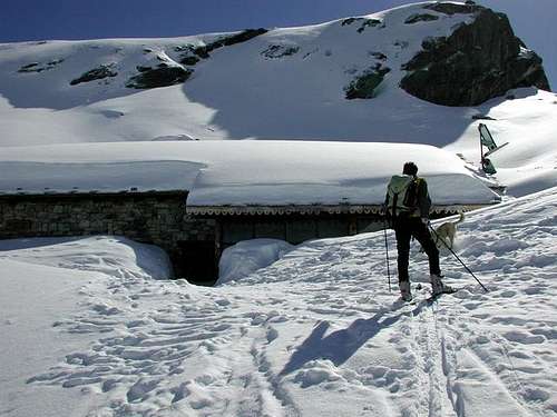
Standard Route From Usellières walk on toward SE (Arolla Pastures - 1.921m), cross the road and go along the path to Montagna di Mont Forciaz (2.180m). Going on toward NNE and, after passing the Fortchat Stream and another secondary one, you can get the Rifugio Chalet de L'Epée (2.370m; 2h'00). On along the Bouc (or Epée) Valley and, leaving on the left side a small lake (2.439m), walk up a debris-snow small valley toward the small Lepère Glacier, climbing in about other 3h'00 the Punta Rabuigne (3.261m) where you must descend along the Northwest side the Glacier de Bouc (30°-38°). Altogheter 5h'00.
Descent Trough the same way.
Via Normale Da Usellières continuare a S-E verso l'Alpeggio di Arolla (1.921 m); oltrepassare la strada poderale e salire il sentiero per la Montagna di Mont Forciaz (2.180 m). Continuare verso N-NE e, guadato il Torrente de Fortchat e un rivo secondario, si raggiunge il Rifugio Chalet de L'Epée (2.370 m; 2h'00). Risalire il Vallone del Bouc o de l'Epée e, lasciato sulla sinistra un minuscolo laghetto (2.439 m), percorrere il sovrastante valloncello detritico-nevoso in direzione del piccolo Ghiacciaio di Lepère raggiungendo in circa altre 3h'00 la Punta Rabuigne (3.261 m) salendo per il versante Nordovest lungo il Glacier de Bouc (30°-38°). Complessivamente 5h'00.
Discesa Tramite lo stesso tragitto.
Difficulty & Equipment
Difficulty This route can be considered F/F+.
L'itinerario è classificato F/F+.
Equipment Standard mountaineering equipment: skis, rope, iceaxe, crampons and helmet.
Da alpinismo: sci, corda, picozza, ramponi e casco.
Huts
 |
Campings
Remember that free camping is forbidden (except for emergency reasons, over 2.500m, from darkness until dawn).
Mountain Conditions
- You can get meteo information at the official site of the Regione Valle d'Aosta:
- Valle d'Aosta Meteo
Webcam
- WEBCAM on Aosta Valley:
- Webcam
Books and Maps
BOOKS:
- "Guida delle Alpi Occidentali", di Giovanni Bobba e Luigi Vaccarone C.A.I. Sezione di Torino Volume II (parte II), 25 Maggio 1896.
- "Guida dei Monti d'Italia–Alpi Graie Centrali" di Alessandro Giorgetta - Club Alpino Italiano/Touring Club Italiano, 1985 (in Italian).
- "Diari Alpinistici" di Osvaldo Cardellina e Indice Generale accompagnato da Schedario Relazioni Ascensioni 1964-2019 (unpublished).
- "La Valle di Rhêmes" di Lorenzo Rossi di Montelera, Ed. Tamari Bologna, Giugno 1978.
 |
 |
MAPS:
- Kompass "Gran Paradiso Valle d'Aosta Sentieri e Rifugi", Carta turistica 1:50.000.
- Studio F.M.B. "Gran Paradiso" Bologna 1:50.000.
- L'Escursionista "Valgrisenche Val di Rhêmes", Carta dei sentieri (n° 3) 1:25.000.
- Enrico Editore Ivrea-Aosta "Gruppo del Gran Paradiso" 1:50.000.
- I.G.C. Istituto Geografico Centrale Torino "Il Parco Nazionale del Gran Paradiso", 1:50.000.
Important Information
- REGIONE AUTONOMA VALLE D'AOSTA the official site.
- FONDAZIONE MONTAGNA SICURA Villa Cameron, località Villard de la Palud n° 1 Courmayeur (AO) Tel: 39 0165 897602 - Fax: 39 0165 897647.
- SOCIETA' DELLE GUIDE DI VALGRISENCHE.
- A.I.NE.VA. (Associazione Interregionale Neve e Valanghe).
Useful numbers
- Protezione Civile Valdostana località Aeroporto n° 7/A Saint Christophe (Ao) Tel. 0165-238222.
- Bollettino Meteo (weather info) Tel. 0165-44113.
- Unità Operativa di Soccorso Sanitario Tel. 118.
Acknowledgements
I am greatly indebted to my friend "Osva" for the detailed description of the route.