
|
|
Mountain/Rock |
|---|---|
|
|
38.98860°N / 120.1333°W |
|
|
El Dorado |
|
|
Hiking, Skiing |
|
|
Spring, Summer, Fall, Winter |
|
|
9183 ft / 2799 m |
|
|
Overview
Rubicon Peak is located in the Desolation Wilderness on the west shore of Lake Tahoe, north west of Emerald Bay. Its close proximity to Highway 89 allows for year-round access. The peak provides fantastic views of the Desolation Wilderness and Lake Tahoe. The great views from the summit can be had for minimal time and effort.The peak can easily be climbed in half a day in any season. For those looking for a full day of peak bagging, nearby PEAK 9269 and Jakes Peak can be added to the agenda. For those looking for an even longer trip, several back country camping opportunities exist in the area that could serve as base camps to additional summits.
Rubicon Peak is on the TAHOE OGUL PEAK LIST.
 Rubicon Peak from the South
Getting There
| Trailhead | Route | Difficulty | Elevation Gain | One Way Distance |
|---|---|---|---|---|
| Highland Drive | Cross Country | Class 2 | 2150ft | 2.4 miles |
HIGHLAND DRIVE (39.009° N, 120.124° W): From the Highway 50/89 junction in South Lake Tahoe, head north on Highway 89 for 14 miles and then turn left onto Scenic Drive. Continue on Scenic Drive by making an immediate right. Head upward, making a left on County Rd 2538, a left on Woodland, a right on Manzanita, a left on Lakeview, a right on Crest, a left on Forest View, a left on High View, and finally a right on Highland. Follow Highland until it dead ends. There is enough space to park 3-4 vehicles at the end of the road. From the trail head, hike up Lonely Gulch for 1.6 miles where you meet Rubicon Peak's north west ridge. Follow the ridge south east for another 0.8 miles to reach the summit. The summit block is class 2 from the south. Note: Scenic Drive meets Highway 89 in two location about a half a mile apart. These directions utilize the southern junction.
Red Tape
Permits are required for day and overnight use in the Desolation Wilderness. Unfortunately, there is no self issue kiosk at this trail head, so permits must be picked up at one of the following locations:PACIFIC RANGER DISTRICT
Located four miles east of Pollock Pines on Highway 50. 7887 Highway 50, Pollock Pines, CA 95726. Phone: (530)644-6048. Winter: Weekdays only. Monday through Saturday as of late April. Summer: 7 days a week, 8:00 a.m. to 4:30 p.m. through October.
LAKE TAHOE VISITOR'S CENTER
Located three miles north of the Highway 50/89 junction at South Lake Tahoe, on Highway 89. Phone: (530)543-2674. Open summer only.
LAKE TAHOE BASIN MANAGEMENT UNIT
Located two miles east of the Highway 50/89 junction in South Lake Tahoe on Highway 50. From the highway turn right on Al Tahoe Blvd. and then turn right at first signal. 35 College Drive, South Lake Tahoe, CA 96150. Phone: (530)543-2600
For more information regarding permits, click HERE.
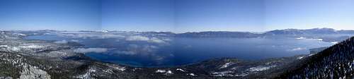 Summit View
When to Climb
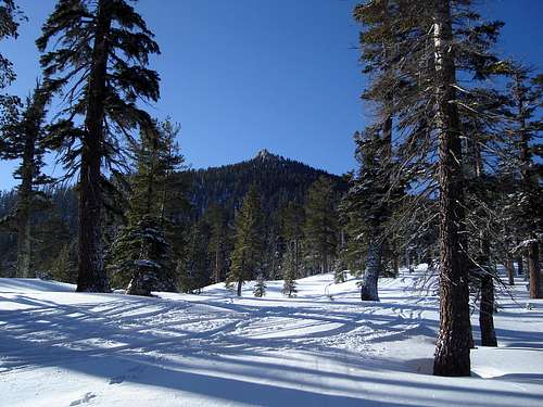
Highway 89 is open year around allowing all season access to peak. While the roads connecting Highland Drive to Highway 89 are plowed in the winter, they are steep, have several sharp turns, and can be icy enough to require chains and/or four wheel drive even when Highway 89 is dry. Caution is advised.The peak is generally snow free from July through September. The area is popular with hikers, snowshoers, and skiers, : do not expect solitude in any season.
Camping
Developed campgrounds can be found at Meeks Bay, D.L. Bliss State Park, Emerald Bay State Park, and Bayview. Fees and facilities vary.The Desolation Wilderness offers excellent back country camping opportunities with its many lakes. Eagle Lake lies in a special management area, please camp in the designated sites only.
 Rubicon Peak from the North
Marmaduke - Jul 29, 2010 1:52 am - Hasn't voted
Class 3 at the summit blockThis is a 2 for 99% of the hike. The summit block is a class 3 with a ridge that has exposure.
MoInfo - Aug 6, 2012 10:05 am - Hasn't voted
Route correctionThere is a recognizable trail now that goes up the NNE-SSW nose directly from the parking spot toward the peak - no need to do bushwhacking up the gulch, etc. Just go thru (around) the gate and continue on the road for about 100 yards and that becomes the trail.