
|
|
Mountain/Rock |
|---|---|
|
|
46.20345°N / 121.52372°W |
|
|
8920 ft / 2719 m |
|
|
Overview
Advisory Note: It can be difficult to reconcile my trail junctions mentioned below with reality. There were a number of junctions. Some were seen outright, some were missed, and some were snow-covered. This report may be helpful. It also describes the continuation to the summit of Mt. Adams.This is a description for a route to the highpoint of Skamania County, which, with one failing swoop on May 18, 1980, transferred itself 25 miles eastward and 740 feet downward to the west slopes of Mt. Adams. Pop goes the Weasel!
The county highpoint has been called "Skamania Pinnacle" even though there really isn't a pinnacle there. The highpoint is what's called a 'liner' because it resides on a county line. That is, just beyond the county line the terrain continues to rise (in this case into Yakima County). And so, by virtue of the lay of the land on this side of Mt. Adams, the highpoint of Skamania County occurs where the county line meets the highest contour on the volcano's West Ridge. This highest contour is 8,920+ ft.
With modern-day GPS units--especially the more powerful/accurate ones--the exact location of the contour-county line touch (tangent) point can be determined with reasonable certainty. But you can never quite know if you're at the exact highpoint. There are no survey marks (and we saw nary a cairn nor register). The best thing to do is to continue climbing up the crest of the West Ridge, passing through 8,920 ft en route, then turn around and come back.
 |  |  |  |  |
Approach Options
There are a number of approaches to the highpoint. A popular route is from the southwest via the Stagman Ridge Trail. See here for some other trip reports. For this route page I will only be describing a route from the direct west via the Table Mountain Trail between Twin Falls Creek and No Name Creek. I believe this route is the shortest of them all and can be done in a day no problem. Recommend a bike and a GPS unit. The bike is useful for the first two miles of trail. The GPS is useful for the confusing forested and undulating terrain after you leave the trail but before you burst out to the alpine. It can also be useful in a whiteout.Pre-map the route
It may be a good idea to input the route on a GPS (using waypoints) in advance and use these to steer yourself. This saved Don and me a lot of time and bewilderment--especially on return.
Table Mountain Trail
Drive FR-23 past the west side of Mt. Adams. The unmarked trailhead is located halfway between mileposts 37 and 38. Elevation is ~3,660 ft.The trail rises moderately (bike pushing territory) for the first couple of miles and eventually reaches a junction at ~4,800 ft in a boggy area (or dry in summer). Head east (left) at the junction. The trail climbs more steepily after the junction in a few switchbacks with roots. Pushing bikes through here will seem exasperating but it is worth it for that serveral hundred yards because the trail flattens out again afterward for another half-mile to another boggy area at ~5,200 ft. Eventually the trail crosses a meadow and fades or makes other junctions that won't be going in your direction eastward to Mt. Adams.
At about 5,400 ft the trail junctions with the trail to Riley Camp then junctions with the PCT closely southwest of Burnt Rock (6,000+ ft). Burnt Rock won't be too visible here as you will still be in the light forest. You won't be using the PCT.
The Cross-Country Part
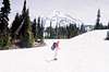
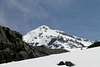
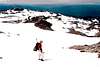
Leave the trail where it meets the PCT and keep ascending progressively more open slopes eastward. The trees end for good at about 6,200 ft, at which point there are a myriad of knobs, swales, ridges, and hollows that will force zigs and zags. In early season snow will ease progress across pumice. In late summer the pumice may punish.Eventually you will be able to see the objective West Ridge high up the mountain. This ridge is distinguished by its deeply undercut north side (freeze-thaw nivation?) hanging over the deep cirque of the Pinnacle Glacier. The county highpoint is located just down the ridge (west of) the undercut part. There is a constant rain of small rocks from this undercut that stirs enough dust into the air to dirty the ridge at about 9,300 ft. In early season the snow will be liberally dusted on the ridge there.
The routes to the highpoint are many. In a whiteout a good option is to adjust your bearing slightly north of due east so as to meet the south fringe of the Pinnacle Glacier (no crevasses at fringe) and take it up the ridge. There is one section where the ridge rises steeply enough to be considered Class 3. You can avoid this by swinging rightward (the left side is more exposed). The final few hundred yards are tedious but inconsequential.
Time = 5-7 hours depending on fitness, 3-4 hours down depending on whether you used a bike or not
Gain = ~5,300 ft
Distance = 6-7 miles depending on how direct your route is
 |  |  |
Continuing to the Summit?
It is feasible to climb all the way to the top of Mt. Adams from the county highpoint (see here). You will only be 3,300 vertical feet from the top. The idea would be to keep going up to below The Pinnacle (12,080+ ft), climbing over its top or circumventing it via easier, though rockbanded, slopes on the right (south) to avoid persistent rockfall on the north. A half-mile of relatively flat slogging will then be required to get to the true summit from The Pinnacle.Essential Gear
A GPS unitIce axe in early season
Gaitors to keep the snow/pumice out of your boots
Mountain bike for the first couple of miles of trail. The ride down is quite nice and quick (20-30 minutes).
millsapd - Sep 6, 2005 11:28 am - Hasn't voted
Route CommentYou will reach Wilderness Area about one mile into the hike - beyond this point you will be illegal with a bike.
Klenke - Sep 6, 2005 9:19 pm - Hasn't voted
Route CommentYes, bikes illegal....
...but if you could have seen the damage the horses made in there behind us while we were up at the cohp you would have seen why I would mention use of bikes. Those horses just tore up the muddy flat areas about two miles up the trail and turned them into hoofed wallows. A bike would never do even one tenth that damage. Beyond 2 miles the bikes aren't worth it. The ride down, however, is super quick. That said, bikes aren't required to do the cohp in a day.
Thanks for the West Ridge continuation report. I will point to it on the route page.
millsapd - Sep 6, 2005 11:30 am - Hasn't voted
Route CommentI did not find a clean junction to the PCT - I ended up going cross-country for about 3/4 mile between Riley Camp trail and the PCT.
millsapd - Sep 6, 2005 11:31 am - Hasn't voted
Route CommentI completed Skamania and Yakima Counties in one go on August 31. I followed the directions to Skamania County’s highest point posted on summitpost by a fellow cohp’er - http://www.summitpost.org/show/route_link.pl/route_id/5731/object_id/13
Except that I have some additional details to note:
1 – I did not find a neat junction between trail 64 (Riley Camp trail) and the PCT. I ended up going cross-country (which is not terribly difficult given the terrain) for about ¾ mile.
2 – I do not recommend bikes. Wilderness area begins about one mile into the hike, and then you will be illegal with a bike.
3 – The place where the county line crosses the west “ridge” is not clear, but the highest ground on the ridge is almost always clear. Just stick to the ridge and climb through the 8920 contour, and you will have reached the high ground.
I chose to continue up the west “ridge” to the summit. Please allow me to elaborate on what I found along the way. Rather than a ridge, I would refer to the upper section of this route as a cleaver. The uppermost part of the rock towers high above the scree slope on the south and the glacier on the north. Because of the tremendously unstable nature of the rock, and its tendency to constantly rain down chunks on the slopes below, I highly recommend staying on top of the cleaver. There is definitely some class 4 near the top of the cleaver. Finally the cleaver fades away just below the Pinnacle. This is where the real fun begins. The Pinnacle is just constantly coming apart, and throwing down various sizes of volcanic debris. I sat there at the top of the cleaver and observed for 15-20 minutes, and there was never really a break of more than 60 seconds in the rock fall. I did note that the majority of it came from the north side of the Pinnacle, and stayed to the north side of the cleaver. However, occasional pieces would bound over the top of the cleaver and make their way down the south side. Also, an occasional piece would break off of the south side of the Pinnacle. It was an interesting sensory experience – especially when one of those pieces went within 20 yards at extremely high rates of speed. So, I could clearly see that exposure to the rock fall was inevitable if I chose to continue. I DID finally continue, very rapidly making my way up and around to the south side of the Pinnacle, briefly near the edge of Blue Salmon Glacier and up to the ridgeline once again. This higher section of the Pinnacle is calmer. There is permanent snow on the north side, so I attached my crampons and kept them on to the summit and back to this point. From the top of the Pinnacle, I traversed across upper Adams Glacier (lots of sun cup action here), crossed below the summit cornice and around by the wooden lodge or shelter, then over to the summit BM. I met a young man named Alex at the top and took his picture for him. He had come up the standard route and was in a hurry to get back down. I also felt the necessity of getting down past the rock fall area and the top of the cleaver, so I did not stay long. I made it back down in good time. Approximate timeframe for the day:
5:45 am left trailhead
9:30 am reached 8920 contour and HP of Skamania County
12:00 pm reached top of cleaver
2:00 pm reached summit
2:30 pm left summit
7:30 pm back to trailhead
Summary ~14 hours, ~18-20 miles RT