
|
|
Mountain/Rock |
|---|---|
|
|
45.74832°N / 122.24783°W |
|
|
Skamania / Clark |
|
|
Hiking |
|
|
Spring, Summer, Fall, Winter |
|
|
4183 ft / 1275 m |
|
|
Overview
Sturgeon Rock is a rocky summit located in Skamania County, Washington. With minor prominence (only approximately 80'), Sturgeon Rock is considered more a sub-peak of Silver Star Mountain's west ridge rather than its own independent peak. However, Sturgeon Rock looks nothing like Silver Star Mountain, and its significance to Washington county highpointers is the primary reason for its inclusion as a separate entity on SummitPost.Although the summit of Sturgeon Rock is located in Skamania County, its western ridgeline, known as "Sturgeon Fin", is primarily located within neighboring Clark County. Most of Clark County contains low-elevation peaks, and the "Sturgeon Fin" ridgetop is where the highest point in the county is located. "Sturgeon Fin" is considered a true liner county highpoint, where the highest point is not on an actual summit but rather a point on a slope. The estimated GPS coordinates for the "Sturgeon Fin" Clark County Highpoint location are: 45.748162, -122.249613. For those people seeking the Clark County Highpoint, it might be best to just hike along the entire ridgetop to/from the Sturgeon Rock summit, just to be certain the county highpoint was encountered.
 Looking West Down "Sturgeon Fin"
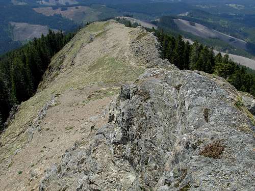
Sturgeon Rock acquired its name from its appearance; it generally looks like the back of a sturgeon. Sturgeon Rock has been referred to as "...a prominent basalt rock outcropping rises about 250 feet above the surrounding terrain and extending on an east to west axis about 1,250 feet." [USBGN List 392 (June 27, 2006), p. 43.]
 Sturgeon Rock
Although some mountaineering sources show Sturgeon Rock as having a summit elevation between 4120'-4160', standard topography maps indicate that is clearly not correct. The overall elevation is definitely higher. Additionally, the actual location of Sturgeon Rock is incorrectly marked on USGS maps. Current USGS maps erroneously label "Sturgeon Rock" as an otherwise forgotten 3080'+ bump located a mile west of the peak, despite the appearance of the true Sturgeon Rock clearly indicating the actual peak location. The official "Silver Star Trails" map indicates an overall elevation of 4183' and correct location which coincides more accurately with standard topography maps and contours. The exact elevation of the Clark County Highpoint, "Sturgeon Fin", is disputed by multiple people but is approximately 4120'.
 Sturgeon Rock Summit
The standard hiking routes to Sturgeon Rock and "Sturgeon Fin" are non-technical and easily attained. However, variations such as the "Sturgeon Stairway" do exist for thrill-seekers.
Getting There
Directions for the standard routes on the south side:From the intersection of Highway 502 & Highway 503 in Battle Ground, WA:
1) Drive north along Highway 503.
2) After 5.5 miles, turn right (east) onto NE Rock Creek Road, which shortly thereafter will become NE Lucia Falls Road.
3) After 8.2 miles, turn right onto NE Sunset Falls Road.
4) After 1.9 miles, turn right onto NE Dole Valley Road.
5) After 5.1 miles, where the pavement stops, turn left onto L-1200 Road.
6) After 4.8 miles, the trailhead parking area is reached. L-1200 Road continues beyond the trailhead parking area. The Grouse Vista Trailhead is the unmarked trailhead on the left (north) side of the parking area, which is the trailhead that leads towards Sturgeon Rock.
Hiking Directions Via Grouse Vista Trail:
NOTE: This is the shortest and least technical route to Sturgeon Rock.
1) Hike north from the Grouse Vista Trailhead (~2375' elevation). The trail soon splits. Take the right-side trail to continue along Grouse Vista Trail (#180F).
2) After 2.1 miles, a trail intersection is encountered. Continue straight (left), towards Silver Star Mountain and Sturgeon Rock.
3) After 0.5 miles, a four-way trail intersection is encountered. The left (west) trail is Sturgeon Rock Trail #180C, leading towards Sturgeon Rock. Take that trail.
(Continuing straight leads to Silver Star Mountain within 0.7 miles, and turning right leads southeast to the Silver Star Indian Pits within 0.8 miles.)
4) Hike west along Sturgeon Rock Trail #180C, passing by the south side of Sturgeon Rock.
5) After approximately 0.4 miles, on the southwest corner of the peak, locate an old boot path/animal track that initially leads northwest and uphill before switchbacking up the rocky slope to the ridgetop.
 Old Boot Path/Animal Track
6) Follow the ridgetop east to "Sturgeon Fin" and Sturgeon Rock. The easiest way to summit Sturgeon Rock is to follow the boot path that passes by its upper south side until on its upper east end, and then follow a straightforward rocky ramp up to the summit.
One-Way Hiking Distance From Trailhead To Summit: 3.25 miles
Hiking Directions Via Tarbell Trail:
1) Hike north from the Grouse Vista Trailhead (~2375' elevation). The trail soon splits. Take the left-side trail, which is known as Tarbell Trail.
2) After 2.8 miles, a trail intersection is encountered. Turn right (east) onto Sturgeon Rock Trail #180C towards Sturgeon Rock and Silver Star Mountain.
3) After approximately 0.9 miles, on the southwest corner of the peak, locate an old boot path/animal track that initially leads northwest and uphill before switchbacking up the rocky slope to the ridgetop.
 Traversing Up Southwest End Of Sturgeon Rock
4) Follow the ridgetop east to "Sturgeon Fin" and Sturgeon Rock. The easiest way to summit Sturgeon Rock is to follow the boot path that passes by its upper south side until on its upper east end, and then follow a straightforward rocky ramp up to the summit.
One-Way Hiking Distance From Trailhead To Summit: 4.0 miles
 Hiking East Along Ridgetop Towards Sturgeon Rock...
The hiking routes can be combined into one large loop, and/or combined with other nearby routes that lead to other noteworthy areas such as Silver Star Mountain, Silver Star Indian Pits, and Pyramid Peak.
 Sturgeon Rock, Silver Star, Pyramid Peak
It is also possible to reach Sturgeon Rock from trails originating north and east of the peak, although those routes require more hiking distance.
As mentioned earlier, a more-technical method of reaching the Sturgeon Rock ridgetop is via the "Sturgeon Stairway" route.
Red Tape
No fees, permits, or parking passes are required to park at the Grouse Vista Trailhead or hike any of the adjoining trails.The trail system is open to visitors year-round, although road access might be unavailable during periods of snowpack. The recommended hiking period tends to be May-November.
Camping
Sturgeon Rock and its western ridge ("Sturgeon Fin") are located within Gifford Pinchot National Forest. As such, camping near the trails is technically possible but greatly frowned upon. Some of the wildflowers and other flora on the mountain slopes might be considered as sensitive species. There are no official campsites along the standard routes leading to Sturgeon Rock.It is recommended to camp at Rock Creek Campground to the southwest or Tarbell Campground to the northwest, which are official campgrounds.