
|
|
Mountain/Rock |
|---|---|
|
|
46.11060°N / 117.6785°W |
|
|
Columbia |
|
|
6387 ft / 1947 m |
|
|
Overview
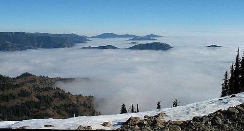 The view from the lookout area atop Oregon Butte
Normally, when you think of a Washington mountain, you think of a lofty volcano or a sky splitting peak with snowy slopes and glaciers hanging all over it. Well, welcome to the other side of the state of Washington, the dry side where the mountains are lower and so is the amount of snowfall. Instead of precipitous peaks, you get peaks with the name "Butte" in them. Diamond Peak and Oregon Butte are the two highest peaks in this section of the state. Nothing lofty but still part of a special mountain range that gave early settlers and those plying the Oregon trail, lots of trouble and hardship, the Blue Mountains.
So why put up a page for a "Butte" here at SummitPost? A fair question.
Oregon Butte is the highest peak in the southeastern part of Washington State and is the highest peak in the Washington section of the Blue Mountain range.
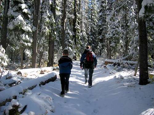
It isn't a difficult nor technical peak but it is one of those special places that make you feel like staying awhile and just kicking back. No lofty summit but plenty of views in all directions. If you live in the southeastern part of Washington State, the Blue Mountains are the peaks closest to home. Nearby Diamond Peak, the highpoint of Garfield county is only 8 feet lower. This is one of those hikes (not a climb) that is a good one for taking children or even a spouse who doesn't normally care to hike on.
It is also the county highpoint of Columbia county and is sought after by those of us who chase after county highpoints. It is also one of the most popular peaks that the locals enjoy as it is not a difficult peak and has an actively manned lookout on its summit. It lies in the Wenaha-Tucannon Wilderness Area and the lookout was built in 1931 and is listed on the Historic Nation Register. (see more below)
The trail to the summit is 3 miles one way and only has an elevation gain of 890 feet, a true walk in the park.
Getting There
Head for the small town of Dayton Washington via US 12 The best way to get to this peak is from Dayton Washington. Turn south on 4th street which also has a sign simply stating SKI on it. This is the route to the ski area SKI BLUEWOOD and, carefully obeying the speed limit, continue 5 miles to a turn on the left which is the unpaved Hatley Gulch road. Go 4.4 miles to its end and turn right onto graveled Skyline Drive. Stay on this road until you go 6 miles and come to a sign indicating that Godman Springs is 12 miles to the right. Turn right on this road and in one mile you come to the Umatilla National Forest. Take the left fork and now you will truly be on Skyline Drive. In some places the road tops the ridge and you have views down into canyons on both sides. Truly one of the unsung scenic roads in our state. In 10.6 miles, you come to a fork in the road, take the left one (FS 4608). If you go to the right you'll end up going uphill to the Godman Springs Campground. It is 6.3 miles on this road to TeePee Trailhead. Prior to reaching the trailhead, you come to a three way fork (about the 4 mile mark) in the road, one of which goes uphill. Take the right fork, this is the one that leads to TeePee trailhead.Update: A new memorial has been placed at the road junction where you turn off to Skyline Drive. See pic at the left.
Mileage was as reported on my vehicles odometer so remember that the mileage may be slightly different for your vehicle. One person noted that the mileage was different for his vehicle so it also helps to study your maps and do some homework just in case. I also shredded one of my tires when I attempted to take my Honda Accord in during one visit so make certain you have a good spare.
Red Tape
It is reported that there is a fee again to park at the TeePee trailhead. Caleb says that the fee is 5 bucks so be aware of this new development.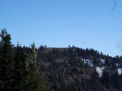
When To Go
Once Skyline Drive is free from snow, generally sometime in May, you can access the TH. The season will extend until snow closes the road sometime in november.
More information can be gleaned from the Umatilla National forest website, or by calling the number 1-877-958-9663.
The trail is known as the Mt. Misery trail, but the Oregon Butte part is not the misery part. The trail starts off from the TH area by entering the woods and ascending an easy grade to the top of a ridge. (see Mt. Misery trail route for full description)
From the summit (lookout area), the generally snowcapped Wallowa Mountain range can be seen to the southwest, about 50 miles away. If you look to the left of the Wallowas (and on a clear day), the peaks of the Seven Devils range in Idaho may be visible. If you look to the southwest, you can also see some of the ski runs of the Bluewood ski area, 8 or 9 miles away.
Camping
You could camp right at the TH in your vehicle or in the nearby woods or Godman Springs Campground, about 8 miles from the TH. You almost pass it on the way in.Also, as you drive along Skyline Drive, there are many places where you can pull off and find nice campspots.
Lodging in Dayton, 33 miles away. Walla Walla is an additional source of shopping and motels.
Mountain Conditions
Check this one for Bluewood, only 8 miles away.Bluewood ski area has a weather forecast site which can give you an idea of whether there is snow there or not.
Oregon Butte Lookout
Here is some special information about this lookout that is atop Oregon Butte. Please take the time to check this out as it will add to your appreciation of this area.Also, check this additional info out here.
There is also an Oregon Butte Lookout located in Idaho so for some strange reason, the name of Oregon Butte is popular in other states. Rumor has it that there is also an Oregon Butte in Oregon.
Columbia County
As Oregon Butte is the county highpoint of Columbia county, lets learn a bit more about this county.As of 2000, the population was 4,064. The county seat is at Dayton, which is also the county's largest city. It is named after the Columbia River. Columbia County was created out of Walla Walla County on November 11, 1875.
Most of the income generated in this county comes from farming.
Good hike for kids
This was a stellar hike for my 9 year old grandson who endured cold weather and snow for this one.He got his first register to sign and was excited by what it meant and found his first benchmark. By all means, consider this as a hike to take your youngsters on but keep them close to you as mountain lions live in these mountains.

Disclaimer
Hiking or climbing in a mountain environment has risks. Any who choose to participate in such activities must assume the responsibility for their own actions and safety. Any information provided here cannot substitute for your own sound judgement and decision making skills. For example, hiking into an electrical storm or during an electrical storm is reckless and dangerous. It is not my intent to describe every risk you may encounter on visiting this area but the author of this page is not resposible for your safety. You needto be prepared for the unexpected and proceed accordingly. All risks are assumed by the participant.