
-
 19861 Hits
-
 88.42% Score
-
 27 Votes
|
|
Route |
|---|---|
|
|
46.01647°N / 7.88887°E |
|
|
Mountaineering |
|
|
Summer |
|
|
A long day |
|
|
PD(-) |
|
|
Overview
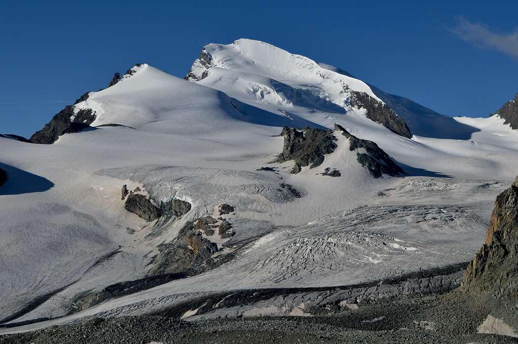
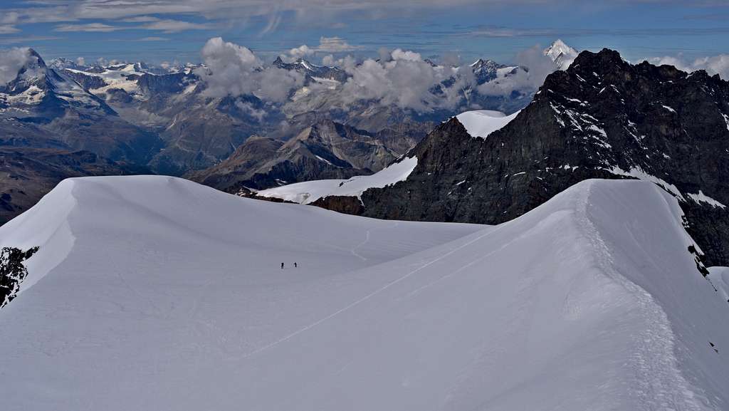
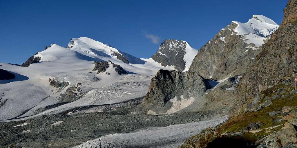
Strahlhorn 4190m from Britannia Hut 3030m
The Strahlhorn is a fairly remote peak situated at the southern end of the chain of mountains dividing the Mattertal and Saastal valleys, in the Pennine Alps of Switzerland. Its position is close to the heart of the biggest collection of 4000m peaks in the Alps. It is also very close to the international border between Switzerland and Italy – and offers a unique view point into both countries. In fact as a view point the summit of this mountain is second to none – and it needs to be, to be worth the effort involved to make one of the long arduous approaches to reach it.
The Strahlhorn normal route is no exception to this principle. The usual starting point is the Britannia Hut, its self fairly easily accessed if you use the Metro-Alpin lift system up from Saas Fee – and walk round from the middle station, at Felskinn. But the ascent from the hut is a long arduous glacier route, initially making a crossing of the Hohlaub Glacier, but then followed by a long weary plod up the larger Allalin Glacier with its infernal crevasse fields. There are two annoying descents involved just to access the Allalin glacier at the start – which means two even more annoying ascents on the way back.
Compensation for all the hard work begins at the upper end of the Allalin Glacier. The route starts to become more scenic as well as safer at the Adler Pass 3789m, when the crevasse fields are finally left behind. The final 400m of ascent is via the broad WNW ridge of the mountain. The first half of this is on steeper slopes of between 35-40°. The final 200m of ascent is via a broad gently sloping plateau – with a mildly exciting finish on a short but spectacular snow crest.
If it wasn’t for the crevasse fields of the Allalin Glacier the route would be graded F or possibly even F(+) with the mild exposure at the summit crest. The added objective danger posed by the glacier gives the route its overall grade of PD(-).
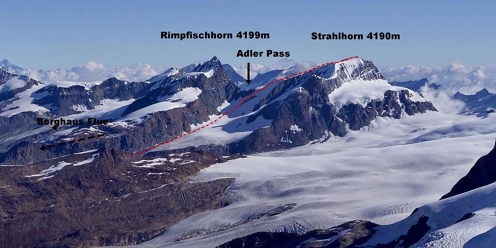
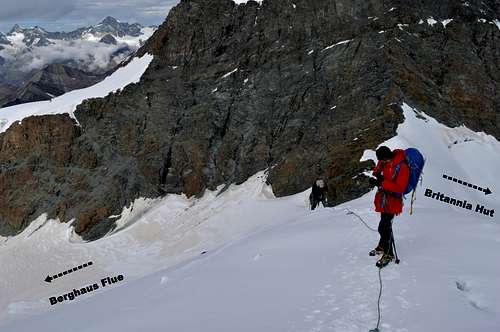
The final 400m of the Strahlhorn WNW flank can also be accessed from the other (southern or Zermatt) side – from Berghaus Flue. This is an even longer approach than from the Britannia Hut – and is graded PD due to steepness and icy nature of the final slopes up to the Adler Pass, on the southern side.
Getting there
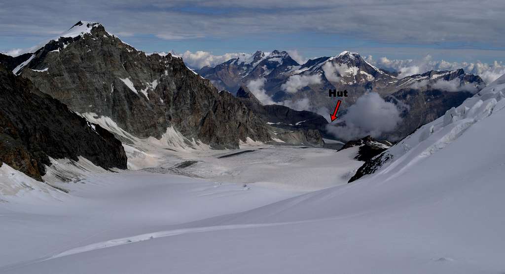
Swiss Alpine Club. One of the largest and busiest huts in Switzerland. Sleeps 134 and full board cost about SF70 with Alpine Club membership in 2014. This is the usual starting point for the Strahlhorn normal route, ascending WNW Flank. It is also the starting point for Allalinhorn 4027m via the Hohlaubgrat – and some routes on the Rimpfischhorn.
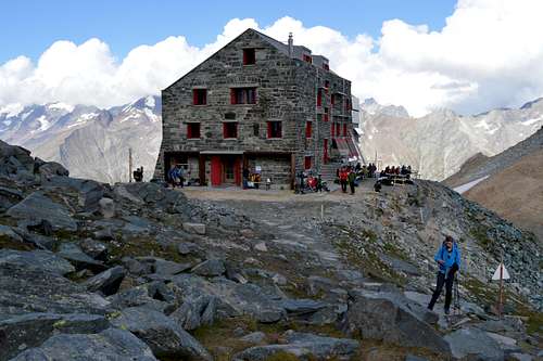 Britannia Hut 3030m | 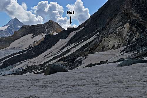 Britannia Hut 3030m from the traverse round from Felskinn |
Approaches:
1) From Felskinn Lift Station 2970m (half way stop on Metro-Alpin system starting at Saas Fee). An almost horizontal track contours round east to southeast, initially on rather unattractive bulldozed piste trail, then on rough track across rather loose boulder slopes before a final scramble up to the hut. This approach is an alpine mountain route which attracts the grade of F – as opposed to just a ‘walk’. Care is warranted due to the significant stone-fall danger traversing the boulder slopes. Danger can be reduced by taking a lower line of approach – or making a crossing as early as possible, when things are still frozen. Time ¾ -1 hour.
2) From Saas Fee. A more attractive but much longer approach is to follow trails up from Saas Fee. This can be reduced to 2 hours with a cable car ascent to Plattjen 2570m and picking up the trail as it winds round the eastern slopes of the Mittaghorn – to reach a small glacier at 2880m – and thence to the hut. Time 3 ½ hours.
A privately owned hotel with both private rooms with beds and dormitory accommodation. Sleeps 60 and full board costs about SF90 in hotel accommodation and SF75 in dormitory (2014 prices). This is an alternative starting point to access Strahlhorn WNW Flank at the Adler Pass but is an even longer route starting from a lower elevation. More usually this hotel would be used for ascents of the Rimpfischhorn, which is just as high, but a little closer than the Strahlhorn. An easier ascent from this location is the Oberrothorn 3414m.
Approaches:
1) From Blauherd Station 2570m (on Zermatt-Sunnegga- Rothorn lift system). An easy walking route via Stellisee leads to the Hotel in about ¾ hour.
2) From Zermatt. A pleasant alpine walk via Findelbach gorge, the village of Findeln and then joining the Blauherd Station trail near to Stellisee leads to the Hotel in about 3 ½ hours.
Strahlhorn 4190m from south, showing Berghaus Flue approach
Route Description
1. Hut to Allalin Glacier
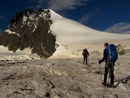
Generally people make a pre-dawn start to climb the Strahlhorn due to the long ascent and advisability of being able to descend the glacier before snow bridges soften too much in the afternoon sun. Thus the initial and mildly complex parts of the route may well be climbed in darkness. As such it is well worth making a study of the route in daylight – on arrival at the hut the previous afternoon. As always, it is worth checking with hut staff for the latest updates on the route and conditions.
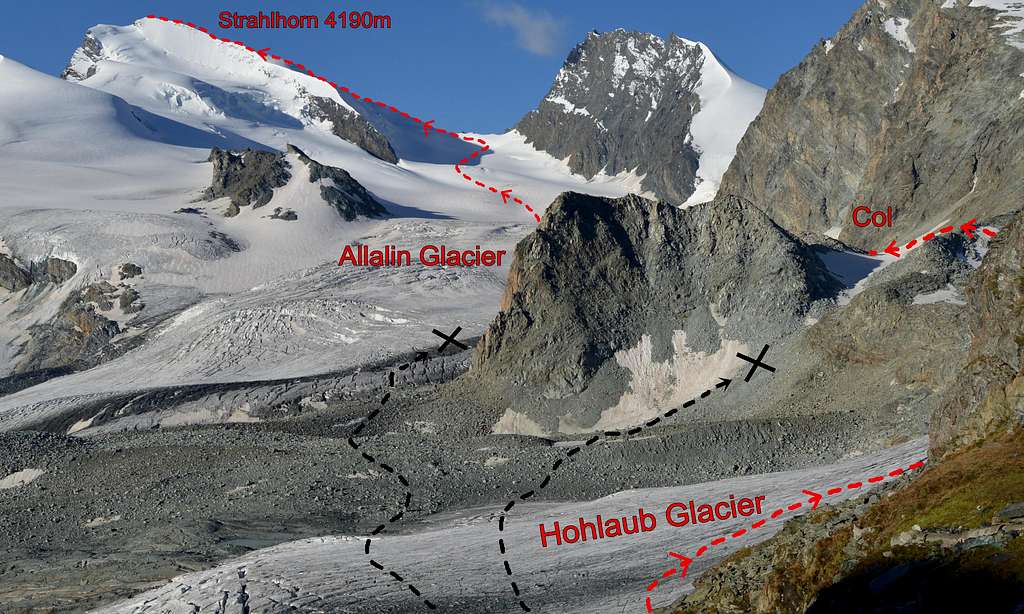
From the hut follow an obvious descending rocky trail southwest from the hut. This is the first of the two descents to be made in the early part of the route and loses about 80 metres of height to reach the Hohlaub Glacier. The most obvious way to reach the larger Allalin Glacier would appear to be to go directly across the much smaller Hohlaub Glacier due south to reach a wide boulder field and thence to join the Allalin Glacier – at a point about 1km from the hut. This direct route can be clearly seen from outside the hut – and is not recommended in summer. The crossing of the boulder field will be highly unpleasant and even dangerous, especially in darkness – and this route joins the larger glacier at one of the worst of its infamous crevasse fields. This route is only recommended in winter when both boulders and crevasses alike are smoothed over by winter snow cover.
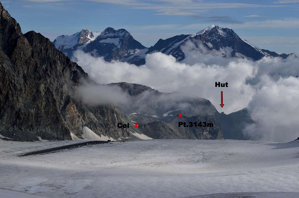
West (right as viewed from hut) of this ‘direct’ route a slightly complex spur projects from the lower extremity of the Hohlaubgrat descending from the Allalinhorn. This spur actually splits into two low down – with a northerly and a southerly ‘arm’ – the latter connecting to a small double headed peak at Pt 3143m, via a small rocky col. This col is the key to reaching the Allalin Glacier. It is also where the second of the two annoying descents starts – dropping 70 metres down to the big glacier.
From the hut it looks tempting to access this col by taking the direct route across the Hohlaub Glacier, crossing a bit of the edge of the boulder field – and then climbing partly unseen slopes between the two spurs – to reach the col. This is also not recommended due to the unsafe loose terrain between the two spurs.
The third and correct option; which cannot be seen from the hut, is to take a more indirect route – and to ascend the Hohlaub Glacier to the west for about a kilometre – passing a small crevasse field to the left. Then a left turn is taken (south) to head straight for the first (northerly) spur which is climbed up easy snow slopes (about 100m ascent above lowest point on glacier). At the top of spur (cairn) head south for 300m over boulders and snow patches to reach the col with bottom of Hohlaubgrat to the right (west) and Point 3143m to the left (east). Now descend approximately 70m of steep boulder slope to join the big glacier at a similar height to departure from hut. Thus quite a lot of effort will have been made to the tune of zero gain in altitude – and there is now another 1200m of ascent still to go! About 1 ½ hours from Britannia Hut.
Strahlhorn 4190m normal route topo
2. Allalin Glacier ascent
 At the little col before the 70m descent to the glacier | 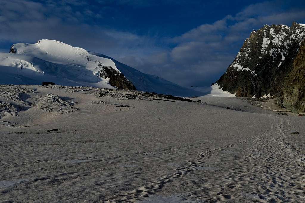 Down on the flat looking glacier - but Adler Pass 700m higher |
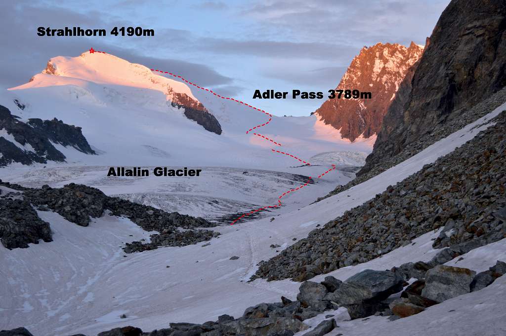
There is now 5km distance and nearly 800m height gain to reach the Adler Pass at 3789m. The average gradient is thus 1 in 5 – although on the ground it looks flat. The effort required to trudge the length of this tedious section is pretty much the only sign that altitude is being gained. It will take 2-3 hours, depending on conditions as well as the state of fitness of the party.
Crevasses in upper Allalin Glacier
At crevasse field below Rimpfischhorn
Objective danger:
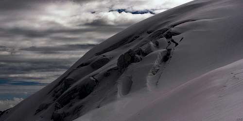
There are numerous crevasse fields on the Allalin Glacier and late season in 2014 hidden crevasse hazard was still an issue. Even the lower and supposedly ‘dry’ glacier was ‘booby trapped’ with thin skims of old snow either trapped in minor wrinkles – or covering a deep crevasse. To look at, you couldn’t tell the difference which – until a boot broke through, if it was a crevasse. The middle of the section, near to the precipices of the east face of the Rimpfischhorn was the most hazardous area, with the greatest concentration of ‘booby traps’. Higher up there was still crevasse hazard but with increasing snow depth crevasse ‘roofs’ were more substantial and less likely to give way.
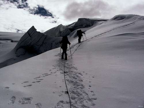
The exact route through this section will vary considerably year to year according to the state of the crevasse fields and snow cover. In late season 2014 tracks followed the right (northern) bank of big glacier, below the precipices of the Hohlaubgrat and within 2-300m of the edge for approximately 1km. Thereafter the main track weaved around crevasse fields gradually tending towards the middle of the glacier. At this point was the notable crevasse field below the Rimpfischhorn east face. This was passed on the left and for a while the trail weaved around undulations and crevasses, in an approximately southerly direction towards the foot of the NNW ridge of the Strahlhorn (PD+ variation to the route – when in condition).
Again, in late season 2014, the main trail then angled away from the foot of the NNW ridge and started gradually increasing in steepness as the Adler Pass was approached. The exact point at which the route joins the Adler Pass at 3789m may vary. In late 2014 it joined about 150m to the left (east) and slightly above.
Note: The even longer and more laborious approach to Strahlhorn WNW flank from the Berghaus Flue joins the Adler Pass at this point. The slopes on this (southern) side are steeper and have a reputation for being icy – giving this route the grade of PD(+).
 Looking back about half way up glacier | 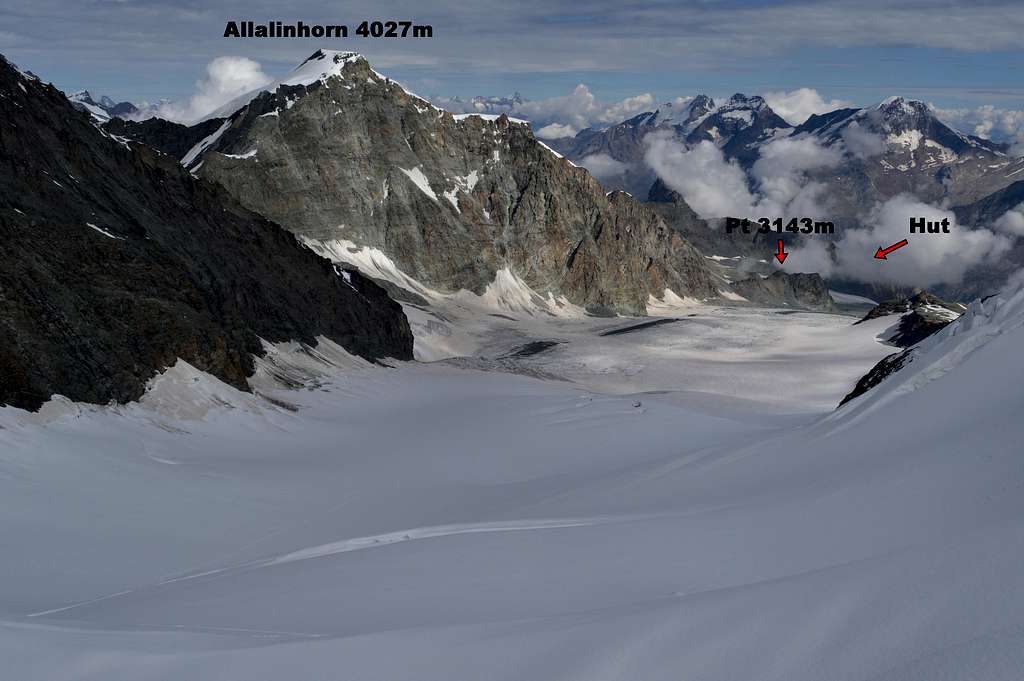 Looking back from the top of the glacier |
3.WNW Flank ascent
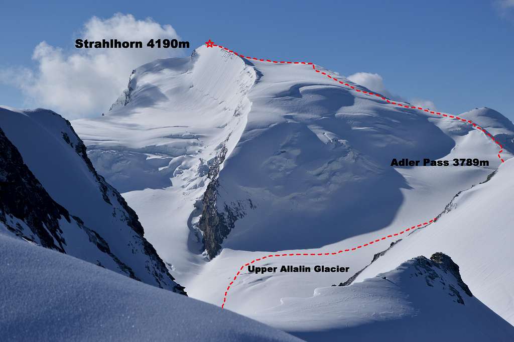
Strahlhorn 4190m WNW Flank from Allalinhorn
Adler Pass 3789m
Above the Adler Pass the route becomes both steeper and more interesting. The angle increases to between 35-40° for the next 200m of ascent. To the north there is now a good view back down the immensity of the Allalin Glacier – and the Britannia Hut may be seen in the distance – emphasizing the considerable distance travelled thus far as well as the now significant gain in height. To the south there are now impressive views towards the Zermatt Valley, with the stunning back drop of the chain of 4000m peaks along the frontier ridge from Liskamm to the Matterhorn. Only Monte Rosa is still hidden behind the bulk of the still substantial amount of Strahlhorn still left to climb.
Ascending the WNW flank above the pass
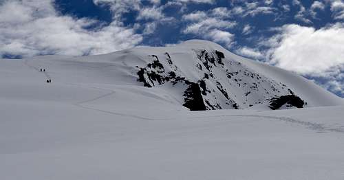
At the end of the mildly steep section and at around 4000m, the gradient eases and what has been a broad ridge opens out into gentle undulating slopes. Looking NE there is a prominent ‘hump’ in sight, which looks as if it might be the summit. But it isn’t. The summit is now about an hour away and is an as yet unseen hump, a few hundred metres beyond the one in view.
The route now meanders in a generally upward direction and passes to the left of the visible hump. Now the summit comes into view – and is about 20 minutes away. It is on the next hump dead ahead and the summit cross can be seen near some rocks and to the right of what looks like the highest point.
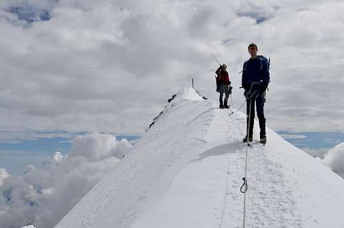
At the final hump the gradient increases to maybe 40° briefly – and then with a right turn a fine little summit crest is reached – at the end of which and some 40m away is the summit cross.
 Strahlhorn 4190m an hour from top - false summit in view | 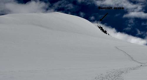 Strahlhorn 4190m 20 minutes from top - beyond false summit |
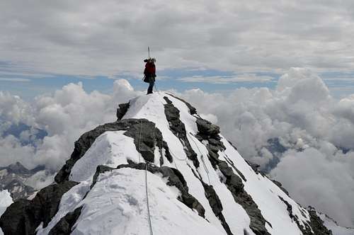
The summit
Strahlhorn summit crest and false summit below (+ two climbers coming up)
The summit of the Strahlhorn is composed of a narrow and horizontal rock ridge, which extends for about another 30m beyond the cross. One of my companions, at my own visit in September 2014, was convinced that the highest point was not at the site of the cross, but at a point about 25m further along this rocky crest. If it were higher, then the difference would be something less than a metre.
As mentioned in the overview above - on a fine day the views from the summit are stunning in all directions – and provide the reward for the long hours of effort involved in getting to see them.
 Last steps to summit of Strahlhorn 4190m | 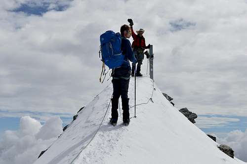 Strahlhorn summit 4190m |
 Further along summit crest - highest point according to rgg | 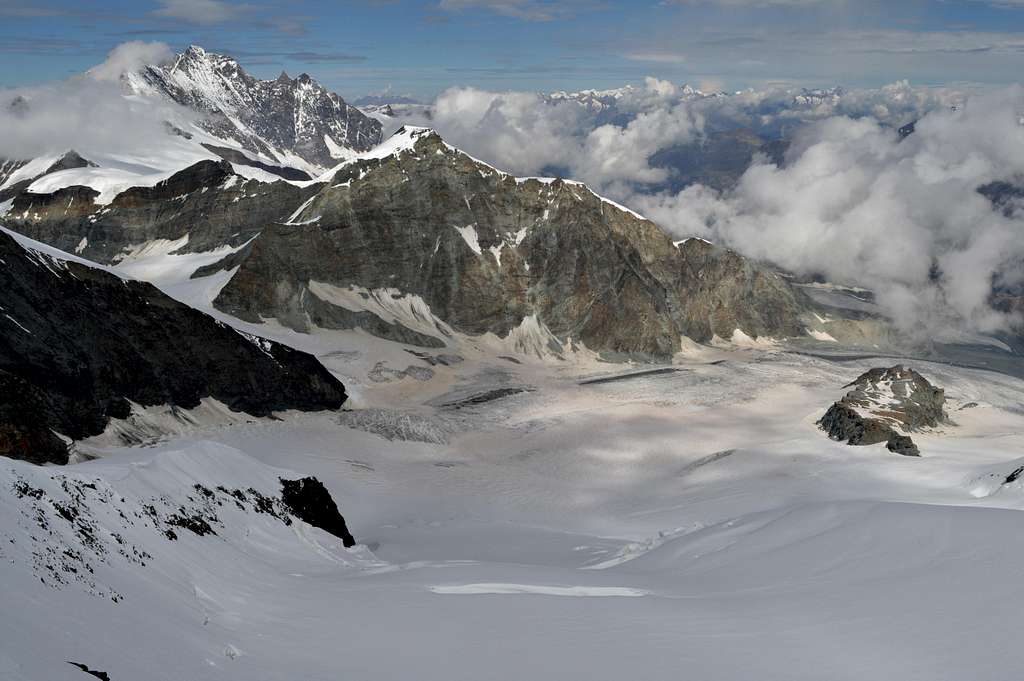 Summit view looking down on Allalin Glacier |
Descent
Long return down the Allalin Glacier
With an established snow trail the 400 metres of descent of the WNW flank, back down to the Adler Pass, is very easy. In poor visibility and with the trail buried under snow, it would be an entirely different matter...
Assuming good visibility and conditions the main challenge in descent is re-negotiating the crevasse fields of the Allalin Glacier when snow has been softened by the sun. Care and concentration is required every step of the way to avoid an unsolicited experience dangling on the end of a rope.
Having successfully negotiated the long kilometres of the big glacier, the next challenges are posed by the two ascents needed to return to the Britannia Hut. First there is the 70 metre high boulder slope to reach the col at the crest of the spur between the Allalin and Hohlaub glaciers. On the other side, after re-crossing the glacier, there is the approximately 80m ascent to re-gain the hut.
If planning to return to the valley now, the middle station of the Metro-Alpin system and return to Saas Fee is a good hour away, reversing the traverse round the mountain described above – see Britannia Hut. It is worth being aware of the time of the last departure for the valley.
 The unwelcome boulder slope leading up to top of spur | 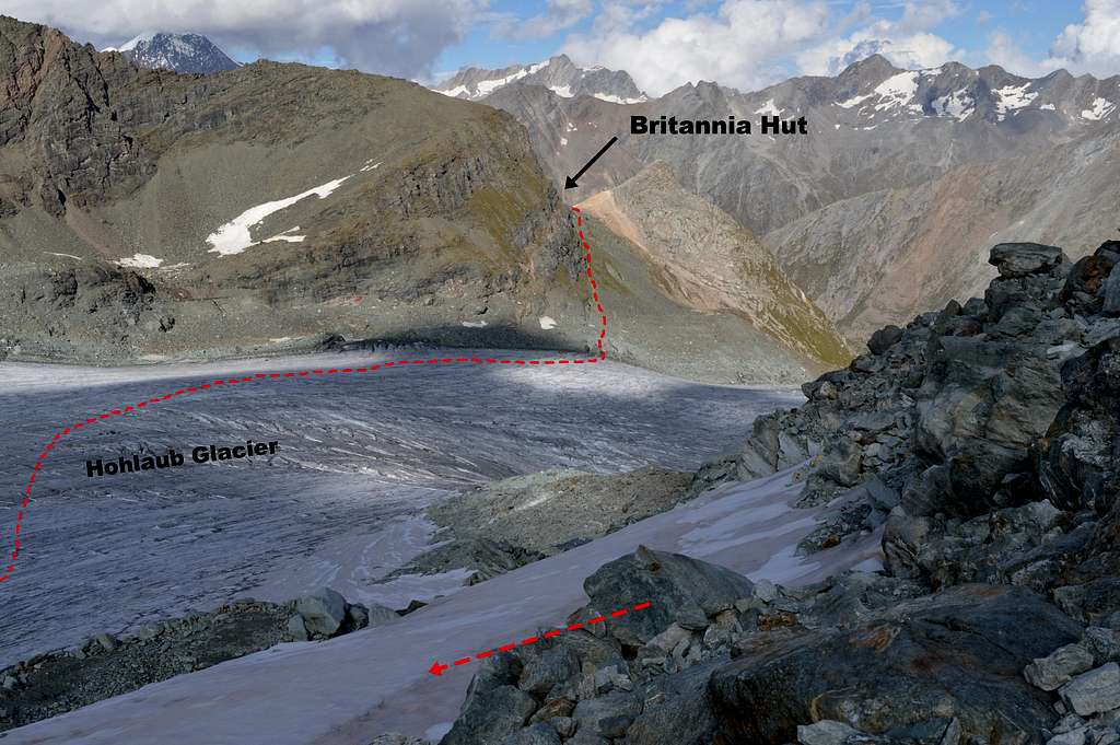 Return to Britannia Hut - 2nd and last bit of ascent on the return |
Essential Gear
Normal alpine attire in anticipation of a possibly cold pre-dawn start – and potential for cold and wind on the upper part of a remote and high alpine peak. Summer alpine temperatures at 3-4000m in the early morning can easily be at around minus 10°C or colder - and if the wind-chill effect is added, the potential for extreme conditions is real. Enough layers of clothing need to be available, with a wind-proof outer layer and snow-gaiters - and attention needs to be given to headwear and hand/finger protection. Sunglasses/snow goggles should be strength 4.
Crampons, ice-axe and walking poles.
Rope (minimum 50m between a party of 2-3) and harness
Crevasse rescue equipment – depending on personal preference – but at a minimum all should carry prussic loops and should know how to use them. Ice screws are to be recommended as an easier alternative to cutting an ice-mushroom. Pulleys are not essential but would greatly facilitate a crevasse rescue if a party has them.
Map, compass/GPS
Safety equipment – headtorch, first aid kit and whistle.
Rescue Insurance is mandatory.
Additional Information
External Links:
Mountain Rescue
International Rescue number 112
Swiss Police 144
Maps
1:25000 Swiss Topo LKS 1328 Randa
1:50000 Swiss Topo LKS 5006 Matterhorn-Mischabel
Guide Books
The 4000m Peaks of the Alps. Martin Moran. Revised and re-printed 2012 by UK Alpine Club.
The Alpine 4000m Peaks. Richard Goedeke. Revised 2006.
German: Walliser Führer, Vol. IV edited by the Swiss Alpine Club.
French: Guide des Alpes Valaisannes, Vol. IV
Italian:
Manuale di alpinismo CAAI – Le Alpi Pennine, il Gruppo del Monte Rosa, i Mischabel
Strahlhorn 4190m, Rimpfischhorn 4199m & Allalinhorn 4027m from Britannia Hut