
-
 4499 Hits
-
 79.78% Score
-
 11 Votes
|
|
Route |
|---|---|
|
|
45.79570°N / 6.81097°E |
|
|
Big Wall |
|
|
Spring, Summer, Fall, Winter |
|
|
Overview
This page concerns the offshoots most Southern of the Mont Blanc Chain. The sector that is contained by the long "Cresta Innominata" to the East over the Val Veny and the watershed from Aiguille de Bionnassay down to the Col de la Seigne (2.514m) marking the border between Italy and France. In the midst between the two drops an intermediate ridge from the Courmayeur Mont Blanc (4.747m) reaches the Breuillat and Marmotte Lakes and just above the Jardin du Miage, separating the great Glacier du Miage (West) from the Glacier du Brouillard or Breuillat. The latter is separated from that of Frêney from the first of those ridges, while a number of glaciers (Glaciers du Petit Mont Blanc, Lex Blanche and Estellette) is placed between the Aiguilles de Tré-la-Tête, and the Aiguilles des Glaciers. Definitely results as a very wild area on the Southern Face of Mont Blanc, frequented almost exclusively by strong climbers and prepared, which in its central part becomes really very difficult and tricky.
Questa pagina riguarda le propaggini più Meridionali della Catena del Monte Bianco. Quel settore che viene contenuto dalla lunga "Cresta dell'Innominata" ad Oriente sopra la Val Veny e dallo spatiacque che dall'Aiguille de Bionnassay scende fino al Col de la Seigne (2.514 m) delimitando il confine tra l'Italia e la Francia. In mezzo alle due scende una cresta intermedia che dal Monte Bianco di Courmayeur (4.747 m) raggiunge i Laghi di Breuillat e Marmotte appena al di sopra del Jardin du Miage, separando il grande Glacier du Miage (Ovest) dal Glacier du Breuillat o Brouillard. Quest'ultimo viene distinto da quello del Frêney dalla prima delle creste citate, mentre una serie di ghiacciai (Glaciers du Petit Mont Blanc, Lex Blanche ed Estellette) é collocata tra l'Aiguilles de Tré-la-Tête e l'Aiguilles des Glaciers. Sicuramente risulta una zona molto selvaggia sulla Faccia Meridionale del Mont Blanc, frequentata quasi esclusivamente da alpinisti forti e preparati, che nella parte centrale diventa veramente alquanto difficile ed ostica.
First ascents
Aiguille Croux (3.251m):- Maria Mazzucchi, Joseph Croux and Hugo Croux, (Aug 20th, 1900).
- Giovanni Battista Gugliermina, Giuseppe Francesco Gugliermina and Joseph Brocherel, (Jul 20th, 1901).
- Martino Baretti and Jean-Joseph Maquignaz, (Jul 28th, 1882).
- Martino Baretti and Jean-Joseph Maquignaz, (Jul 28th, 1880).
- Edmond Thomas Coleman, Frédéric Mollard and Joseph Jacquemont, (Sep 02th, 1858).
- E. Del Carretto, Francesco Gonnella, Laurent Proment, Ange and Gratien Henry, (Aug 02th, 1878).
- A. A. Reilly, E. Whymper, Michel Croz, Michel Payot and Henry Charlet, (Jul 12th, 1864).
- V. Attinger, Louis Kurz, Jean-Baptiste Croz and Joseph Simond, (Jul 25th, 1889).
Route Description
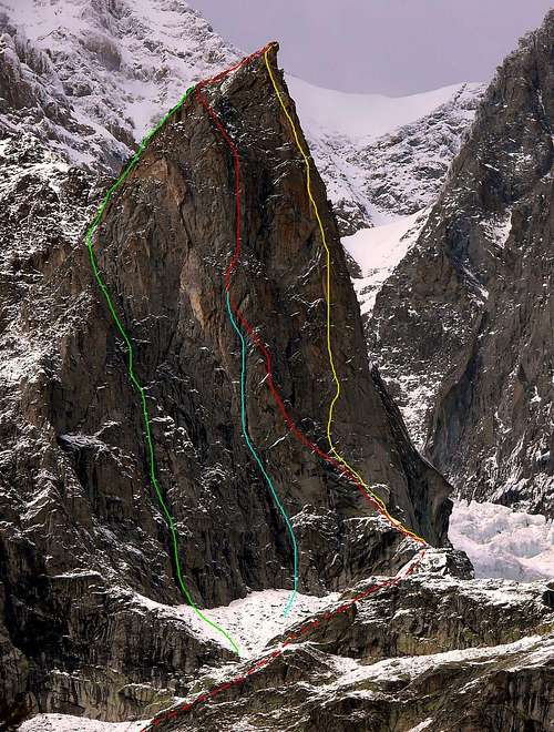

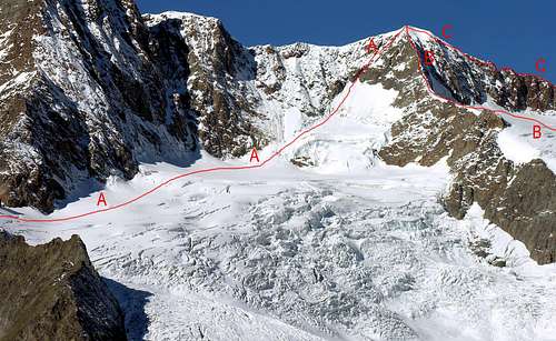
Route Description A) = Brouillard ridge (normal route): Giovanni Battista Gugliermina, Giuseppe Francesco Gugliermina and Joseph Brocherel, (Jul 20th, 1901). Difficulty: AD.
B) = Direttissima: Patrick Gabarrou and Alexis Long, (Jul 28-29th, 1984). Difficulty: ED+ Length: 400m.
C) = Pilastro Rosso: Walter Bonatti and Andrea Oggioni, (Jul 05-06th, 1959). Difficulty: IV°+/V+°/VI°/A1/A2/TD+ Length: 400m.
|
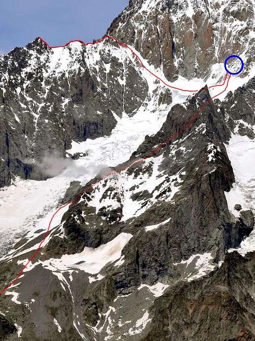
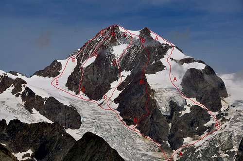
Route Description A) = NW side: Georges Sonniers and A. Chappeland, (Jul 05th, 1937). Difficulty IV°.
B) = NNW side: E. Grillon and J. Denis, (Aug 03th, 1957). Difficulty IV°.
C) = NW face: Patrick Gabarrou and M. Colin, (Sep 12th, 1974). Difficulty D+.
D) = NW couloir: J. C. Henry and J. Mussillon, (Jun 03th, 1960). Difficulty AD. Lenght 400m.
E) = NW ridge: C. Bosviel and Alphonse Estivin, (Sep 19th, 1895). Difficulty AD.
|
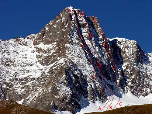
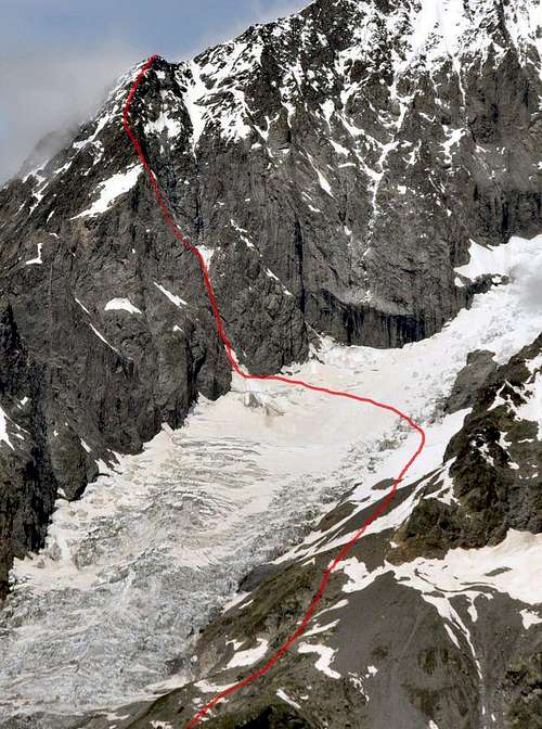
Route Description A) = "E wall route Sylvie": Dario Brocherel and Mario Mochet, (Apr 18th, 1982). Difficulty IV°/V°/TD-. Inclination 50°/70° Lenght: 520m.
B) = "E wall central route": Gabriele Boccalatte, Piero Ghiglione and Mario Piolti, (Sep 04th, 1933). Difficulty IV°/D. Lenght: 500m.
C) = "E wall right Eperon": Guido Machetto and Miller Rava, (Jul 24th, 1972). Difficulty III°/IV°/V° D. Lenght: 500m.
|
Route Description A) = S side (for the suspended glacier): Albino Pennard and companion (1954). Difficulty: PD+/AD.
B) = S ridge: Francesco Gonella, Alexis Berthod and Joseph Petigax, (Jul 26th, 1887). Difficulty: PD+/AD.
C) = S side: J. Buzio and R. Gréloz, (Jul 20th, 1954). Difficulty: AD+. Lenght: 400m.
D) = SSW wall: J. Duchosal and R. Gréloz, (Jul 31th, 1938). Difficulty: AD+.E) = SW ridge: Martino Baretti, Jean-Joseph Maquignaz, Auguste Sibille and Victor Sibille, (Aug 08th, 1878). Difficulty: PD+/AD-.
|
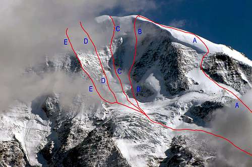
Route Description A) = SW face: Edouard Pennard and companions, (Sep 12th, 1959). Difficulty: AD.
B) = E ridge: A. Brofferio, E. Santi and Ugo di Vallepiana, (Jul 17th, 1908). Difficulty: PD.
C) = N ridge: Victor Attinger, Louis Kurz, Jean-Baptiste Croz and Joseph Simond, (Jul 25th, 1889). Difficulty: PD.
|
Essential Gear
Complete alpine equipment.Attrezzatura alpinistica completa.
MAPS:
Refuges and Bivouacs
- Rifugio ELISABETTA SOLDINI Tel. 0165 844080
- Rifugio FRANCESCO GONELLA Tel. 0165 885101
- Rifugio FRANCO MONZINO Tel. 0165 809553
- Bivacco ADOLFO HESS (2.958m)
- Bivacco GINO RAINETTO (3.047m)
- Bivacco QUINTINO SELLA (3.363m)
- Bivacco MARCO CRIPPA (3.850m)
- Bivacco GIUSEPPE LAMPUGNANI-GIANCARLO GRASSI (3.860m)
- Bivacco PIERO CRAVERI (3.490m)
- Bivacco LORENZO BORELLI (2.325m)
- Bivacco DELLA BRENVA (3.200m)
- Bivacco ALBERICO-BORGNA (3.680m)
- Bivacco LUCIA e PIERO GHIGLIONE (3.685m)
Books and Maps
BOOKS:- "Guida delle Alpi Occidentali", di Giovanni Bobba e Luigi Vaccarone C.A.I. Sezione di Torino Volume II (parte II), 25 Maggio 1896.
- "Guida dei Monti d'Italia-Monte Bianco" (Vol. I°) di Gino Buscaini-Club Alpino Italiano/Turing Club Italiano, 1994 (in Italian).
- "I Rifugi della Valle d'Aosta" di Stefano Ardito, Ed. Guide iter, Febbraio 2003.
- "A piedi in Valle d'Aosta" (Vol. 1), di Stefano Ardito, Ed. Guide iter, Giugno 2003.
- "80 itinerari di Escursionismo Alpinismo e Sci Alpinismo in Valle d'Aosta", di Osvaldo Cardellina, Ed. Musumeci, Giugno 1977 (in Italian); seconda Ed. Luglio 1981; terza Ed. Luglio 1984; (in French), prima Ed. Febbraio 1978; seconda Ed. Marzo 1980.
 |
 |
 |
 |
 |
- Kompass "Massiccio del Monte Bianco Valle d'Aosta Sentieri e Rifugi" Carta turistica 1:50.000.
- I.G.C. Istituto Geografico Centrale Torino "Massiccio del Monte Bianco" (n° 4), Torino, 1998 1:50.000.
- I.G.C. Istituto Geografico Centrale Torino "Monte Bianco-Courmayeur-Chamonix-La Thuile" (n° 107), 1:25.000.
- Kompass "Massiccio del Monte Bianco Valle d'Aosta" Carta escursioni, bike e sci alpinismo 1:50.000.
- L'Escursionista "Monte Bianco Courmayeur" (n° 1) Edizioni Rimini 2004 1:25.000.
- IGN Carte de randonnée CHAMONIX - MASSIF DU MONT BLANC 3630 OT 1:25.000.
- Edizioni Tabacco "Mont Blanc" Udine, 1978 1:50.000.
- Studio F.M.B. Bologna 1988 "Monte Bianco-Mont Blanc" 1:50.000.
- IGN institut géographique national genoble mont-blanc parc national de la vanoise (n° 53), 1:100.000.
 |
 |
 |
 |