
-
 11044 Hits
-
 79.78% Score
-
 11 Votes
|
|
Route |
|---|---|
|
|
45.83040°N / 6.86644°E |
|
|
Big Wall |
|
|
Spring, Summer, Fall, Winter |
|
|
All |
|
|
Overview
Mont Blanc is the highest mountain in Europe, Elbrus apart. Situated between three countries (Italy, France and Switzerland), of which only the first two reach the Summit (4.811m), determined in a conference in Turin in 1861 and now being well questioned. Its topography is complex and very articulate, place names, in part, still shrouded in mystery and the Mountaineering History has expanded dramatically reaching our days and projected to the future. For these exact reasons the writing of this specific page. We see them in together. Topography: the Mont Blanc Chain stretches from the Southwest to the Northeast with a series of Summit forming numerous satellites and reaching the French-Swiss border, but the real Mont Blanc and right can be outlined between the Aiguille de Bionnassay in West and Mont Maudit North. Large glaciers descend towards the South and East and are called Bionnassay, Miage, Mont Blanc, Brouillard, Frêney and Brenva, separated from each other by large ridges that sometimes reach the valley floor and other important Summit as the rocky Aiguille Jean Joseph Croux and the black and slender Aiguille Noire de Péuterey (to the South above La Lex Blancge Valley) and the Tour Ronde and the Giant Pass (towards the East and above Mer de Glace). While in the North and towards the Savoy expands a great sea of ice traversed by dangerous crevasses and great seracs that go down over the Town of Chamonix-Mont Blanc, just at the feet. The Topononymy: varied, however, is largely formed by Frenchified names like Maudit, Tacul, Miage, Brouillard, Frêney, Péuterey, Taconnay or Taconnaz, Bossons, Bionnassay, Gouter, Mont, Aiguille, Clocher, Pilier, Angle, Couloir, Arête, Dome, Capucin, Trident, Pyramide, Roi, Grands Mulets, Corridor, Angle, Mur de la Cote, Poire, Androsace, Diable, Capucin, Adolphe, Siam, Fourche etc. Others in Italian as Innominata, Via, Sperone, Canalone, Cresta, "Canne d'organo" or in "patois" (local dialect French-Provencal) as the Brenva, the name of a plant at the foot of the glacier with the same name. There are also many place names that bear the name of great mountaineers, devoted time to the same as Baretti, Sella, Gugliermina, Croux, Moore, Anderegg, Rey, Graham Brown, Graven, Aufdenblatten, Chabod, Grivel, Gervasutti, Boccalatte, Gonella, Ghiglione, Bonatti, Zappelli etc. But of all emerges the first to say Maudit or "Cursed Mountain", because with this definition was seen this terrifying "eternal monster" of ice and rock that sowed fear among the people at his feet with large and "smoky" terrible snowslides, avalanches and landslides from the slopes, that often reached even the sources of Dora Baltea.
The Story: it has a beginning of a long time before the mountaineering dated around 1750 with the maximum objective achievement, that is, the Summit, in August 1786. At first they were hunters exploring moraines, ridges and cliffs to hunt, in those days not prohibited, of marmots, chamois and ibex; later came the "christalliers", that is the crystals researchers, in great demand by scholars and collectors. Among these are just two of them, the famous "christallier" Jacques Balmat (after called "Mont-Blanc") and renowned Dr. Gabriel Paccard to reach first the coveted trophy. Even encouraged by the passionete Professor Horace Bénédict De Saussure Geneva that, starting with the observations from South made by the small Mont Crammont (above Pré St. Didier Common), order had also set up a cash prize. Reaching, not long after, he himself the Top. Then the conversation is dilated to almost infinite ...
Il Monte Bianco é la più alta montagna d'Europa, Elbrus a parte. Situato tra tre nazioni (Italia, Francia e Svizzera), delle quali esclusivamente le prime due raggiungono il Vertice (4.811 m); questo risulta determinato in Convegno svoltosi in Torino nel 1861 ed oggi ampiamente ridiscusso dalle parti in causa. La sua topografia risulta complessa ed alquanto articolata, la toponomastica, in parte, ancora avvolta nel mistero, almeno nei confronti di alcuni antichi toponimi, mentre la Storia Alpinistica si è ampliata a dismisura proiettandosi anche verso il futuro. Per questi precisi motivi la validità della stesura di questa pagina. Vediamoli tutti nel logico lor insieme. La Topografia: la Catena del Monte Bianco si allunga da Sudovest a Nordest con una serie di Vette che raggiungono il confine franco-svizzero, ma il Monte Bianco vero e proprio può essere delineato tra l'Aiguille de Bionnassay ed il Mont Maudit. Grandi ghiacciai scendono verso Sud ed Est e prendono il nome di Bionnassay, Miage, Monte Bianco, Brouillard, Frêney e Brenva separati tra di loro da grandi creste che a volte raggiungono il fondovalle ed in altre Sommità importanti come l'Aiguille Croux e l'Aiguille Noire de Péuterey (verso Sud) nonché la Tour Ronde ed il Colle del Gigante (ad Oriente verso la Mer de Glace). Mentre a Nord verso la Savoia si espande un enorme mare di ghiacci attraversato da pericolosi crepacci e grandi seraccate dei Ghiacciai Taconnay e Bossons, che quasi raggiungono l'abitato di Chamonix-Mont Blanc, situato giusto alle pendici. La Toponomastica: di vario tipo, risulta però in gran parte formata da nomi francesizzati come Maudit, Miage, Brouillard, Frêney, Péuterey, Taconnay o Taconnaz, Bossons, Bionnassay, Gouter, Mont, Anguille, Clocher, Pilier, Angle, Couloir, Arête, Dome, Pyramide, Roi, Grands Mulets, Corridor, Mur de la Cote, Poire, Androsace, Diable, Capucin, Fourche ecc. Altri in italiano come Innominata, Via, Sperone, Canalone oppure in dialetto "patois" come Brenva dal nome di una pianta che cresce alla base delle pendici del ghiacciaio. Toponimi riportanti nome di grandi alpinisti, dedicati nel tempo ai medesimi come Baretti, Gugliermina, Croux, Moore, Gervasutti, Boccalatte, Gonella, Ghiglione ecc.. Ma tra tutti emerge il primo toponimo, ovvero Maudit o "Monte Maledetto", perché con questa definizione veniva in tempi antichi visto e classificato questo "mostro eterno" formato da ghiaccio e roccia che seminava paura, terrore e sconforto tra gli abitanti ai suoi piedi raggiungendo a volte anche le sottostanti sorgenti del Fiume Dora Baltea.
La Storia: ha un inizio che precede di molto tempo quella alpinistica databile intorno al 1750 con il raggiungimento dell'obiettivo massimo, cioè la Cima, nell'Agosto del 1786. Dapprima erano stati i cacciatori ad esplorare morene, creste e dirupi alla caccia, a quei tempi non vietata, di marmotte, camosci e stambecchi; in seguito sono arrivati i "christalliers", ovvero i ricercatori di cristalli, molto ambiti da studiosi e collezionisti. Tra questi saranno proprio due di loro, il famoso "christallier" Jacques Balmat (poi soprannominato "Mont-Blanc", come da lui desiderato ed ottenuto) ed il rinomato Dottor Gabriel Paccard a raggiungere per primi l'obiettivo. Anche incentivati dall'entusiasta Professore ginevrino Horace Bénédict De Saussure che, iniziando da osservazioni effettuate dal piccolo Mont Crammont, allo scopo aveva pur istituito un premio in denaro. Poi il discorso si è dilatato quasi all'infinito …
First Ascent
- From Chamonix: Jacques Balmat and Michel Gabriel Paccard, (Aug 08th, 1786).
- From Courmayeur - Route dei Trois Mont Blanc: Julien Grange, Adolphe Orset, Jean-Marie Perrod and Reginald Head, (Aug 13th, 1863).
Route Description
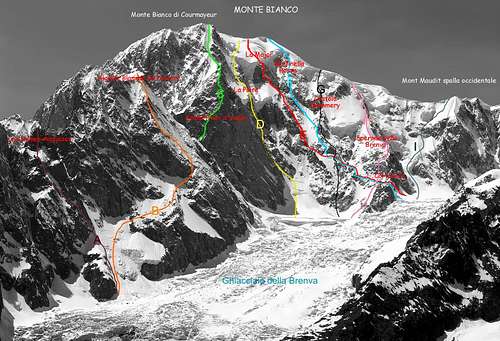
Route Description A - Versante NW: Luigi Amedeo di Savoia, duca degli Abruzzi, Laurent Croux and Ciprien Savoye, (Aug 07th, 1901). Difficulty IV+/D.
B - Via storica: Paul Güssfeldt, Emile Rey, Christian Klucker and César Ollier, (Aug 15th, 1893). Difficulty AD+ Length: 1.300m C - Walter Bonatti and Cosimo Zappelli, (Oct 11-12th, 1963). Difficulty V+/TD+ Length: 1.050m.
D - The via della Pera: Graven A. Aufdenblatten and T. Graham Brown, (Aug 05th, 1933). Length: 600m Difficulty: III/IV/TD.
E - Major: T. Graham Brown and Francis Sidney Smythe, (Aug 6-7th, 1928). Length: 1.300m Difficulty: IV+/TD-.
F - Sentinella Rossa: T. Graham Brown and Francis Sidney Smythe, (Sep 1-2th, 1927). Length: 1.300m Difficulty: D/TD-. G - Costola Mummery: Robert Gréloz and André Roch, (Aug 08th, 1936). Difficulty D+ Length: 1.300m.
H - Sperone della Brenva: G. S. Mathews, A. W. Moore, Jacob Anderegg, Melchior Anderegg, F. Walker and H. Walker, (Jul 15th, 1865). Difficulty D- Length: 1.300m Inclination 40°-45°.
I - Mont Maudit spalla occidentale: J. M. Chabod, G. Bareux, M. Chabod, A. Clusaz, A. Fenoillet, J. M. Perrod and A. Proment, (Sep 28th, 1854). Difficulty D- Length: 700m Inclination 50°.
|
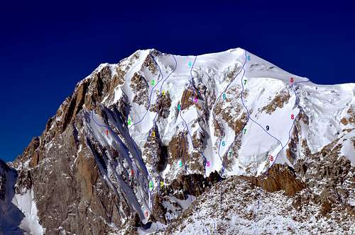
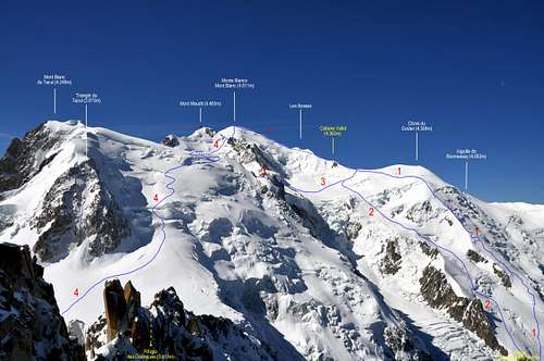
Route Description 1) - Parete Nord (via Bonatti-Zappelli): Walter Bonatti and Cosimo Zappelli, (Jun 22-23th, 1962). Difficulty: ED- Length: 750m total length for Monte Bianco summit 1.350m.
2) - Seracco di sinistra della Poire: Gianni Comino and Giancarlo Grassi, (Aug 10-11th, 1979). Difficulty: TD+.
3) - La Poire: Alexsandre Graven, Alfred Aufdenblatten and T. Graham Brown, (Aug 05th, 1933). Difficulty: IV/TD Length: 1.300.
4) - Pilastri S della Major: Pierre Mazeaud and Roberto Sorgato, (Aug 17-18th, 1971). Difficulty: V+/ED Length: 1.300.
5) - La Major: T. Graham Brown and Francis Sidney Smythe, (Aug 06-07th, 1928). Difficulty: IV+/TD- Length: 1.300.
6) - Sentinella Rossa: T. Graham Brown and Francis Sidney Smythe, (Sep 01-08th, 1927). Difficulty: D+ Length: 1.300.
7) - Costola Mummery: Robert Greloz and André Roch, (Aug 08th, 1936). Difficulty: D+ Length: 1.300.
8) - Sperone della Brenva: G. S. Mathews, A. W. Moore, F. Walker, H. Walker, Jakob Anderegg and Melchior Anderegg, (Jul 15th, 1865). Difficulty: D- Length: 900m total length for Monte Bianco summit 1.300m.
9) - Diagonale: Armand Charlet and M. A. Azéma, (Jul 02th, 1937). Difficulty: D.
|
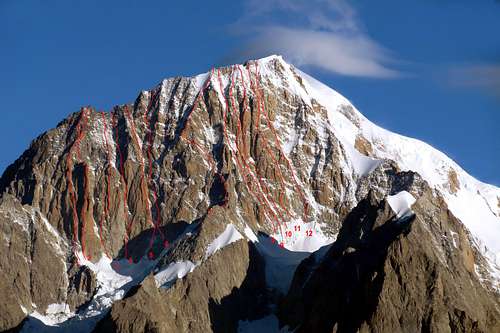
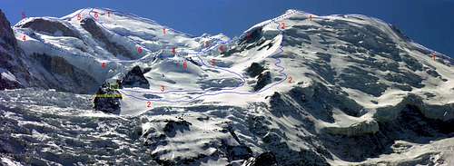
Route Description 1) - Cresta del Brouillard versante E: V. Bressoud, René Dittert, W.Marquart and Francis Marullaz, (Jul 28th, 1933). Difficulty: III/D Length: 1.000m.
2) - Pilastro di sinistra: Ryszard Kovalewski, Janusz Maczka and Wojciech Wroz, (Aug 13-14th, 1977). Difficulty: TD/VI.
3) - Pilastro Rosso: Walter Bonatti and Andrea Oggioni, (Jul 05-06th, 1959). Difficulty: IV+/V+/VI/A1/A2/TD+ Length: 400m total length for picco Luigi Amedeo 650m.
4) - Pilastro Centrale, parete S (via Polska): Andzey Dworak, Marek Groschowski andv Wojcieck Jedlinski, (Aug 16-17th, 1971). Difficulty: V+/TD+ Length: 350m total length for Cresta del Brouillard 600m.
5) - Hypergoulotte: Benoit Grison and Lionel Mailly, (Apr 20th, 1984). Difficulty: ED+/EX- Length: 600m.
6) - Pilastro di destra (via Bonington): Chirs Bonington, John Harlin, Robert Baillie and Brian Robertson, (Aug 21-22th, 1965). Difficulty: VI+/A2/TD+/ED- Length: 300m total length for Cresta del Brouillard 600m.
7) - Sperone SE: Patrick Gabarrou and Alexis Long, (Jul 20-21th, 1983). Difficulty: VII/TD+/ED Length: 700m.
8) - Sperone del Brouillard: B. Bougé, R. Ducournau, J. Franchon and R. Mizrahi, (Jul 13-14th, 1975). Difficulty: IV/V/V+/TD Length: 700m.
9) - Canaloni SE Innominata (via Innominette): Patrick Gabarrou and Alexis Long, (Jul 09th, 1985). Difficulty: V/TD Length: 700m.
10) - Cresta dell'Innominata: Adolf Aufdenblatten, Adolphe Rey, Henri Rey, S. L. Courtauld and E. G. Oliver, (Aug 19-20th, 1919). Difficulty: III/IV/D+ Length: 1.000m.
11) - Fianco E cresta dell'Innominata: Henri Agresti, Jean-Marie Galmiche and Francis Leduc (Aug 18th, 1973). Difficulty: IV/V/V+/A1/TD Length: 700m.
12) - Parete S (diretta Bonatti-Zappelli): Walter Bonatti and Cosimo Zappelli, (Sep 22th, 1961). Difficulty: TD Length: 850m.
13) - Pilone Centrale di Frêney (via classica): Chirs Bonington, Don Whillans, Y. Clough and J. Duglosz, (Jul 27-28-29th, 1961). Difficulty: V+/A1/A2/ED Length: 800m.
14) - Parete S del Pilone Centrale (via Jöri Bardill): Jöri Bardill, Michel Piola, and Pierre-Alain Steiner, (Aug 10-12th, 1982). Difficulty: V+/A2/ED-/ED+ Length: 800m.
|
|
1) - From the Hump of the Dôme du Goûter: A. Millot, M. Payot, H. Charlet and A. Payot, (Aug 19th, 1872). Difficulty: PD Length: 1.800m.
2) - From Grand Mulets Normal Route from Chamonix: H. Headland, G.C. Hodgkinson, C. Hudson, G.C. Joad, Melchior Anderegg, François Couttet and two Mountain Guide, (Jul 29th, 1859). Difficulty: PD Length: 1.750m.
3) - From the Corridor and Mur de la Côte: Charles Fellows, William Haves, Mathieu Balmat, Michel Balmat, Joseph-Marie Couttet, Pierre-Marie Couttet, Simon Devouassoud, Michel Favret, David Folliguet, Joseph Payot and Pierre-Joseph Simons, (Jul 25th, 1827). Difficulty: PD/PD+ Length: 1.750m.
4) - NW Ridge from Mont Blanc du Tacul and Mont Maudit Pass: R.W. Head, Julien Grange, Adolphe Orset and Jean-Marie Perrod, (Aug 13th, 1863). Difficulty: PD/PD+ Length: 1.500m.
|
Route Description 1) - NW Ridge or de Bosses from Aiguille du Goûter (normal route): Leslie Stephen, Francis Fox Tuckett, Melchior Anderegg, Johann-Josef Bennen and Peter Perren, (Jul 18th, 1861). Difficulty: F+/PD- Length: 1.000m.
2) = From the Hump of the Dôme du Goûter: A. Millot, M. Payot, H. Charlet and A. Payot, (Aug 19th, 1872). Difficulty: PD Length: 1.800m.
3) - From Grand Mulets Normal Route from Chamonix: E. Headland, G.C. Hodgkinson, C. Hudson, G.C. Joad, Melchior Anderegg, François Couttet and two Mountain Guide, (Jul 29th, 1859). Difficulty: PD Length: 1.750m.
4) - From the Corridor and Mur de la Côte: Charles Fellows, William Haves, Mathieu Balmat, Michel Balmat, Joseph-Marie Couttet, Pierre-Marie Couttet, Simon Devouassoud, Michel Favret, David Folliguet, Joseph Payot and Pierre-Joseph Simons, (Jul 25th, 1827). Difficulty: PD/PD+ Length: 1.750m.
5) - NW Ridge from Mont Blanc du Tacul and Mont Maudit Pass: R.W. Head, Julien Grange, Adolphe Orset and Jean-Marie Perrod, (Aug 13th, 1863). Difficulty: PD/PD+ Length: 1.500m.
6) - From Grand Mulets - Grand Plateau and le Bosses: Jacques Balmat and Michel-Gabriel Paccard, (Aug 08th, 1786). Difficulty: PD Length: 1.500m.
|
Essential Gear
Complete alpine equipment.
Attrezzatura alpinistica completa.
Refuges and Bivouacs
- Cabane VALLOT (4.362m)
- Bivacco QUINTINO SELLA (3.363m)
- Bivacco MARCO CRIPPA (3.850m)
- Bivacco GIUSEPPE LAMPUGNANI - GIANCARLO GRASSI (3.860m)
- Bivacco PIERO CRAVERI (3.490m)
- Bivacco ALBERICO-BORGNA (3.680m)
- Bivacco LUCIA e PIERO GHIGLIONE (3.685m)
Books and Maps
BOOKS:
- "neige, glace et mixte" le topo du massif du Mont-Blanc (Tome 2) de L'Envers des Aiguilles au bassin de Tré-la-Tête, François Damilano JMEditions.
- "MONTE BIANCO (1)" Guida Vallot, settori: Monte Bianco, Vallée Blanche, Aiguilles de Chamonix, Edizioni Mediterranee, Ristampa settembre 2003.
- "Guida delle Alpi Occidentali", di Giovanni Bobba e Luigi Vaccarone C.A.I. Sezione di Torino Volume II (parte II), 25 Maggio 1896.
- "Guida dei Monti d'Italia-Monte Bianco" (Vol. I°) di Gino Buscaini-Club Alpino Italiano/Turing Club Italiano, 1994 (in Italian).
- "Guida dei Monti d'Italia-Monte Bianco" (Vol. II°) di R. Chabod, L. Grivel, S. Saglio, G. Buscaini-Club Alpino Italiano/Turing Club Italiano, 1968 (in Italian).
- "80 itinerari di Escursionismo Alpinismo e Sci Alpinismo in Valle d'Aosta", di Osvaldo Cardellina, Ed. Musumeci, Giugno 1977 (in Italian); seconda Ed. Luglio 1981; terza Ed. Luglio 1984; (in French), prima Ed. Febbraio 1978; seconda Ed. Marzo 1980.
- "I Rifugi della Valle d'Aosta" di Stefano Ardito, Ed. Guide iter, Febbraio 2003.
 |
 |
 |
 |
 |
 |
 |
MAPS:
- Kompass "Massiccio del Monte Bianco Valle d'Aosta Sentieri e Rifugi" Carta turistica 1:50.000.
- I.G.C. Istituto Geografico Centrale Torino "Massiccio del Monte Bianco" (n° 4), Torino, 1998 1:50.000.
- I.G.C. Istituto Geografico Centrale Torino "Monte Bianco-Courmayeur-Chamonix-La Thuile" (n° 107), 1:25.000.
- Kompass "Massiccio del Monte Bianco Valle d'Aosta" Carta escursioni, bike e sci alpinismo 1:50.000.
- L'Escursionista "Monte Bianco Courmayeur" (n° 1) Edizioni Rimini 2004 1:25.000.
- IGN Carte de randonnée CHAMONIX - MASSIF DU MONT BLANC 3630 OT 1:25.000.
- Edizioni Tabacco "Mont Blanc" Udine, 1978 1:50.000.
- Studio F.M.B. Bologna 1988 "Monte Bianco-Mont Blanc" 1:50.000.
- IGN institut géographique national genoble mont-blanc parc national de la vanoise (n° 53), 1:100.000.
 |
 |
 |
 |
Acknowledgements
The fundamental support given by my friend "Osva" for the "Overview" with translation.