Day 1: Hike in to Arrowhead Lake: Sept. 12, 2011
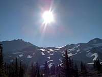
![Moonlight view from Triangle Lake of North and Middle Sister]() A light collecting photo of the moon over North and Middle Sister at Arrowhead Lake.
A light collecting photo of the moon over North and Middle Sister at Arrowhead Lake.
My two climbing partners and I started our Three Sister’s summit quest driving to Obsidian Trialhead from Bend, Oregon passing through Sister’s and then accessing the trailhead from McKenzie Highway 242 around 4:30pm on September 12, 2011. This first leg of our trip started late in the afternoon because two of us drove in from Corvallis that morning. With the late start, we did not reach Arrowhead Lake until 7:30pm which was just in time for the sunset and gave us enough time to set up camp before it got dark. The hike from Obsidian Trailhead (4800 feet) to Arrowhead Lake (6800 feet) was a gradual uphill hike measuring 4 to 5 miles and was tiring with our heavy packs. Early on in the hike, we passed through a lava flow and then went on to cross some meadow creeks on the way to our turnoff leading up to Obsidian Waterfall. Once at the waterfall, we followed the trail through an alpine meadow with a creek surrounded by obsidian flows until we arrived at a big rock cliff that we scrambled up to get to Arrowhead Lake that sit’s overlooking the forests to the west and looks out at North and Middle Sister to the east. I highly recommend Arrowhead Lake for an overnight camp site for climbing North or Middle Sister because of the access to water and excellent views.
Hike in Time: 2 hours 45 minutes
Day 2: Climbing North and Middle Sister: Sept. 13, 2011
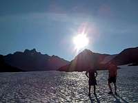
![Sunrise Approach to North and Middle Sister]() Sunrise approach to North and Middle Sister on Collier Glacier
Sunrise approach to North and Middle Sister on Collier Glacier![Starting our climb on to North Sister]() Starting our climb of North Sister.
Starting our climb of North Sister.![North Sister south west ridge.]() North Sister south west ridge about half way up.
North Sister south west ridge about half way up.![Climbing over some rock walls near summit on North Sister.]() Climbing over a rock wall on the upper slopes.
Climbing over a rock wall on the upper slopes.![The last few obstacles to North Sister s summit.]() The last few obstacles to North's Summit.
The last few obstacles to North's Summit.![Looking down North Sister s south west ridge to Middle Sister.]() North's south west ridge looking at Middle.
North's south west ridge looking at Middle.![Middle Sister s north ridge.]() Middle Sister's north ridge.
Middle Sister's north ridge.![Climbing a steep section on Middle Sister.]() Climbing a steep section on Middle.
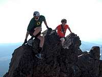
Climbing a steep section on Middle.![Middle Sister summit south view.]() Middle Sister summit south view.
Middle Sister summit south view.
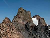
On our first day of climbing, we left camp around 9am climbing down from Arrowhead Lake and followed some rock trails up the slopes until we reached Collier Glacier. In the beginning being new to glacier travel, we moved up the slopes walking on top of the rocks. However, we soon discovered it was safer and we moved more quickly walking on the ice. The approach was very beautiful as we not only passed many interesting geological features, but we also were treated to a late sunrise that reflected light off the glacier ice as we climbed because the mountains had blocked the sun out until 9:30am. When we got to the top of the glacier after about an hour of climbing we could see the saddle between North and Middle Sister. Our original plan was to only climb Middle Sister, but our visual inspection of North Sister convinced us that North Sister from the south west ridge looked climbable. We were aware that North was the most dangerous of the Three Sister’s but the danger only motivated us. We wanted to test ourselves against the mountain and agreed that we would turn around when the climb became too dangerous for us to go any further.
North Sister: 10,085 feet:
The ascent of North Sister started on the south west ridge where a glacier divided North Sister from Middle Sister at around 8800 feet elevation. The rocks at the base of the mountain were large red builders and got smaller and more unstable as we ascended up slopes that reached as much 45 degrees in angle. The angle of the slopes and the extremely loose nature of the red rock convinced us we needed to climb up the slopes providing space between each climber. This plan worked out well as one climber would scout a route for the other and warned the other not to climb that route because of loose rocks or lack of stable hand or legs holds. I personally aimed to keep three points of contact at all times; however, there were times when I only managed a few or zero stable holds. The strategy that seemed to work the best was staying near the larger rocks. This strategy seemed to provide more stability, but in retrospect this was just a theory that worked for us.
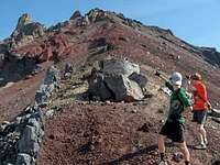
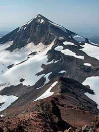
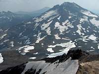
When we got about half way up the slope it got less steep, but we still had to climb with up most alertness as the small pebble size rocks would slide me about half the way back down with each steep I took. As we walked, we came across the first major rock features. We were able to pass them easy without climbing over them but we took the time to climb up on them and take pictures. The view is amazing as you can see Middle, South, Broken Top, Bachelor, Jefferson and some other mountains as well. You can also see glaciers lakes inside of crevassed ice with outstanding blue water.
The upper third of the mountain is rockier and requires doing vertical climbing up some 5 to 10 foot walls and moving up some boulder alleys. We managed to climb these sections with little difficulty but there was some route selecting involved and descending the same route you came can be difficult. We climbed until we reached a point where we deemed it too dangerous to continue. This place ended up being a few hundred feet shy of the true summit in elevation and involved climbing over a camel hump and a 50 to 100 foot vertical rock to the summit. My research since then suggests this route is not a normal summit route. The north ridge and east face from where we were are more common summit routes but involve technical climbing gear to reach the summit. So in retrospect, we climbed as high as we could safely without specialized gear and I am very proud of that. I personally feel this was a successful climb despite not reaching the summit.
The descent from our summit varied little from the route we climbed to get there. We decided on the way up that one section was too exposed to repeat on the climb back down. We treated the decent more seriously then the climb up and scouted routes and waited for climbers to clear sections before the next climber moved down. This worked very efficiently and we descended slowly but safely from the upper slopes.
About 65% of the way down, we deviated from the south west ridge and climbed down the east face. This was overall a bad decision because the slope while shorter was steeper and more dangerous. There was a point when I was caught between two boulder groups with an open space in between with no holds with a climbing partner about 50 feet directly below. If I moved, I could have caused rock fall to roll down on to him. He was struggling through that section down below himself and it was the tensest moment of our trip. After he cleared out below me, I had to climb down carefully and hop to a more stable rock to get to a safer spot on the slope. From there, I climbed down another 100 feet, but it was difficult climbing down until I reached the glacier and glissaded down to safety. I was relieved to be off the mountain at that point.
Feeling a high from just climbing North Sister, we were approached by two young climbing rangers lecturing us about climber safety. We had been aware they were down below watching us for a few hours and could hear them talking to each other nearly a thousand feet below us on the mountain because of the way sound traveled on the mountain. I had a hard time not smiling when spoken to but their advice was valid and we have taken it in to consideration seriously since then. We really appreciated them and realized they were only trying to keep us alive on future climbs and made us feel looked after when climbing Middle. When asked why we decided to climb North Sister because it is a monster compared to climbing the other two I said, “It was there.”
I will state that anyone considering this mountain should know that it is dangerous and take the correct precautions. Eleven days after we finished our climb an experienced 36 year old male mountaineer slipped while climbing North Sister on the west face and tumbled 500 feet to his death. Soon after a storm with whiteout conditions and 60mph winds halted the body retrieval. I am not sure but I believe his body is still up there until they can go back and get it next climbing season.
Middle Sister: 10,047 feet:
After our free climber safety seminar with the climbing rangers, we quickly turned our attention toward climbing Middle Sister. We hiked off Collier Glacier and jumped on to the long rock ridge on the north side of the mountain. The hike up the rock ridge was fairly easy until we climbed about 85% of the way up and hit a steep section that matched the slopes of North Sister. The difference between North and Middle is that the ground it far sturdier on Middle Sister and on Middle you can dig your feet in and just climb upward; however, normally on this route you would not need to climb the section I am talking about because there is not a ice sheet covering part of the north ridge route that late in the season.
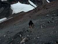
Still with Middle’s sturdier rock it does not mean rock fall is not a danger on Middle Sister. A rock avalanche occurred as we approached the mountain not far from the normal route that we believed was triggered by the only other climber we saw that day and his dog. We figured his reasoning for taking an odd/questionable route down the mountain was avoiding that very section.
When we passed the steep section it was a short distance to the summit where we spent 5 to 10 minutes taking pictures and then started our descent down the mountain.
On our way back down, we thought that we may have strayed off trail and that was the reason for the steep climb up. When we attempted to follow the trail we ran in to the ice sheet and we were forced to climb around it which was a little more difficult than climbing up, but we made it. Once past, we reconnected with the north ridge and followed it down the mountain and back on to Collier Glacier where we retraced our route back to camp and had some fun getting some glissading in on the way.
Total Climbing Time: 8 hours and 45 minutes
Day 3: Hike from Triangle Lake to Moraine Lake: Sept. 14, 2011
Since our unplanned climb of North Sister resulted in second night camped at Arrowhead Lake, we faced a long 14 mile hike to Moraine Lake (6600 feet) near the base of South Sister. This hike ended up being our most physically demanding day of the trip because we had to carry our packs the entire day. We stopped at Obsidian Waterfall for about 20 minutes before leaving the Obsidian area. We then hiked to Reese Lake along the Pacific Crest Trail for lunch and an afternoon swim which lasted for an hour or so. We then proceeded to push to Moraine Lake walking 25 minutes straight and then taking 5 minute breaks to get our bags off our backs.
Total Hike Time: 8 hours 20 minutes
Day 4: Climbing South Sister: 10,358: Sept. 15, 2011
![Moraine Lake looking at South Sister.]() Moraine Lake looking at South Sister.
Moraine Lake looking at South Sister.![3 Peaks 3 Days 3 Sisters.]() 3 Peaks 3 Days 3 Sisters
3 Peaks 3 Days 3 Sisters![Broken Top.]() Broken Top from South summit.
Broken Top from South summit.![View descending South Sister.]() View descending South Sister.
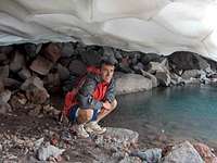
View descending South Sister.![User Profile Image]() Under Lewis Glacier near it's lake.
Under Lewis Glacier near it's lake.
The morning of the South Sister climb we were hit with colder temperatures and windy weather during the night. We stayed in the tent until noon waiting for the weather to improve but it did not so we decided at noon we would leave to climb South Sister. From Moraine Lake, we accessed the South Sister climbing trail and hiked up it as it overlooked Moraine Lake and the near by lava flows. When we reached about 7500 feet in elevation we passed the cloud level and the weather improved as the wind die off and it was sunny for the rest of the climb.
South Sister is not difficult but it has interesting geological features with a variety of rock types. The first rock level consisted of big gray rock slabs. These rocks were technically the biggest obstacle to climbing South Sister and this rock level is the only place on the mountain where I put my hand down for support. We ran in to an older man perhaps in his late 60’s or early 70’s on the trail that turned around after attempting to climb this section.
The next level is the volcanic scree field leading up to the summit. This rock is very light and you sink in to it as you walk and it is by far the most tiring part of climbing South Sister. The scree field only lasts roughly 1800 feet elevation wise but it seems longer because of the effort.
When we reached the summit we walked across the crater to the other side where the view of North and Middle Sister are. We were sort of bummed the wind the night before had drained the batteries in the camera and our cell phones so we could not photograph our last and monumental summit of the trip. However, we were awarded with a pleasant surprise when the camera turned on at the summit and we began taking rapid fire pictures because we did not know how long it would stay on. While on the summit, we rested for about 30 minutes and I ate my lunch trying to ignore a chipmunk begging for my food. I was not going to be sympathetic to this chipmunk because one had stole my entire bag of nuts mix while we climbed North and Middle Sister. I am still amazed to this day how cleanly that chipmunk stole my food. All that remained was the bag.
The descent down the South Sister scree field was a hundred times easier than climbing it. We jogged down it and then checked out a glacier lake cave underneath Lewis Glacier that was a cool sight to see. We then continued down below the next rock level where we took a break sitting by a log before going back down below the cloud level to our windy camp at Moraine Lake.
Total Climbing Time: 5 hours
Day 5: The Hike Out
The morning of the fifth and last day of our trip we hiked out from Moraine Lake to the South Sister Trailhead off of the Cascade Lakes Highway where one of my climbing partners father had parked his vehicle. His dad hiked in the previous night and slept in the tent with us because of the cold/windy weather. When I gathered water that morning from the lake its edges had iced over suggesting it got cold. We personally were not dressed to be cold. The temperature was near 90 degrees at the beginning of the trip.
Total Hike Time: 1 Hour
Trip Albums
I have prepared albums for North, Middle, and South climbs for those of you that are more visual. They are located on my trip report page and on the parent pages for these climbs.


Comments
Post a Comment