
-
 21293 Hits
-
 79.04% Score
-
 10 Votes
|
|
Mountain/Rock |
|---|---|
|
|
39.24480°N / 120.2851°W |
|
|
Placer |
|
|
Hiking |
|
|
Spring, Summer, Fall, Winter |
|
|
8949 ft / 2728 m |
|
|
Overview
Tinker Knob is a bump on the ridge seen from I-80 looking SW while driving SW through Truckee; however, it has a few distinctions:
- SPS Peak List member: http://angeles.sierraclub.org/sps/SPSPkXlsht.htm
- Tahoe OGUL Peak List member: http://climber.org/wsc/OGULlist.html
- Western States Climbers List member: http://www.climber.org/wsc/WSClist.html
- It's the highest bump on the ridge :p
Though not the highest peak in Placer County (#2), the highest, Granite Chief (#1), along with Anderson Peak, Mt. Lincoln, Mt. Judah, and Donner Peak can be linked, depending on your direction/commitment level. Tinker knob lies just off the PCT, it is a very short class 1/2 walk up the NE shoulder from the PCT; it requires little time (maybe 15 min. one way) once off the PCT.
Getting There
Directions depend on which approach approach trail. Since the the Pacific Crest Trail (PCT) runs right past the summit on its eastern flank, hiking the PCT in either direction will get you there. Some of the Possible trail heads are:- PCT at Old Donner Summit Road, just east of Lake Mary (~7450'). GoogleMaps
- Granite Chief Trailhead, Squaw Valley, just after turning into Chamonix Pl off of Squaw Valley Rd. GoogleMaps
- End of Cabin Creek Road; this is a Forest Service Road and is subject to closure. GoogleMaps
Route
Note: all distances are one way.
PCT From North - 8.0 miles - 2000' (~500' lost) - vertical
Follow the signage though Sugarbowl Ski Resort, crossing the Lincoln/Judah Col, gaining the ridge running SE to Tinker Knob. Follow the trail past Anderson Peak (on its SW flank), then climb the NE shoulder of Tinker Knob (see description below). Possible bonus peaks along the way: Donner Peak, Mt. Judah, Mt. Lincoln, Anderson Peak.
Granite Chief Trailhead - 7.0 miles - 3149' (~500' lost) vertical
This route starts off of Chamonix Pl near Squaw Valley Rd. Care must be taken when hiking this way. First of the trail does not follow USGS or Forest Service maps, nor did it match the trail on my GPS; there are a lot of feeder trails of the main trail and it is quite possible to take the wrong one coming back and end up in some neighborhood. In a nutshell, the trail gains altitude continuously until the PCT is reached, then you take that north to Tinker Knob. There is a use trail to the summit on the NE shoulder (see description below), so try to resist the temptation to go direct, unless that is what you are about.
End of Cabin Creek Road
The length of this route and vertical is entirely dependent on what kind of clearance your car has; it you don't have a 4x4 you may be stopped long before the end of the road. Having gone this way, I can say that we didn't quite make it to the end of the road in our 4x4, but we came very close (~2 miles one way, maybe 1200' vertical); there was a point where the rocks got too big, but with the right lift you might make it. If all goes well, this route is way shorter than either legit PCT route.
The route starts at the gate, at the beginning of the green line on the map above. You will gain elevation for a ways then the road will drop down steeply; I would recommend not staying on the road as it switchbacks down below the ridge; stay on the use trail that rides the ridge top; eventually you will gain a hiking trail that will lead up to the PCT. This route offers excellent views of the crags on the ridge SW of Tinker Knob.
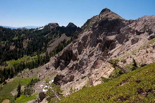 Peak 8761 SE of Tinker Knob
When the trail hits PCT, go NW. Follow PCT until you get to the "Tinker Knob" sign on the NE shoulder. Possible other bonus peaks: Anderson Peak.
Tinker Knob NE Shoulder:
The final part of the route is a simple climb up the NE Shoulder of the summit formation. Follow the use trail from the "Tinker Knob" sign up towards the NE side (the right side of the formation in the image below).
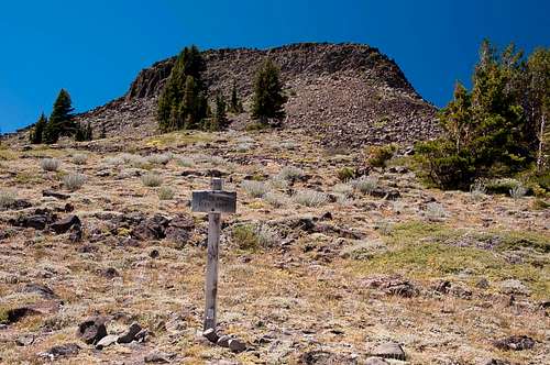 Sign for Tinker Knob summit use trail
Take the use trail up until it fades; climb class 2 terrain to the summit following the NW shoulder.
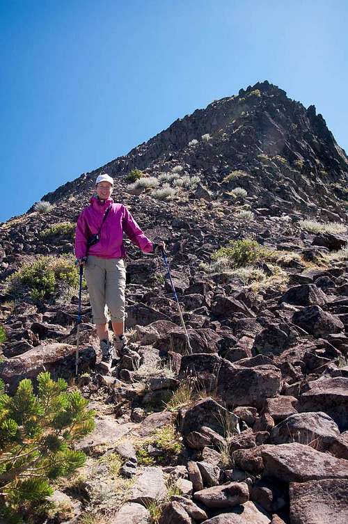 Anna on Tinker Knob's NE Shoulder
 Enjoy the summit!
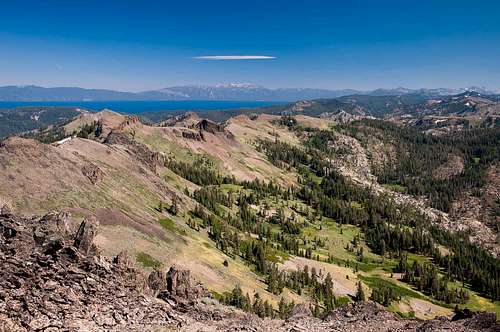 Looking SE from the summit of Tinker Knob
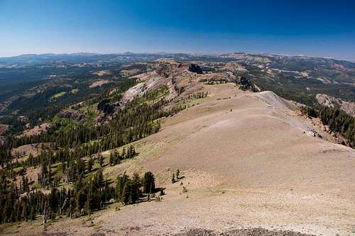 Looking NW from the summit of Tinker Knob
kevinlr5 - Aug 30, 2017 8:30 pm - Hasn't voted
More info about Squaw Valley routeI just did this hike from Squaw Valley. The old topo maps do not have the PCT on them. Instead they have old unmaintained trails that go down the Mountain Meadow Lake drainage. These trails still exist, but they're not obvious from the Granite Chief Trail and I believe that the forest service is trying to do research back there and they don't want people hiking on them. When hiking south on the PCT, there's a sign that says 'Ecological Research Area' on a tree at the trail junction between the PCT and the disused trail. Also, the use trail up the northeast shoulder of Tinker Knob starts about 150 feet north (and out of sight) of the sign. This was a little confusing coming from the south, but it doesn't really matter if you take it or just go cross country.