Bischof (center) as seen from Pürschling (02/2009)
An interesting name for a mountain: Bischof / Bishop. I don´t know where it derives from. I am not aware that this mountain has a shape like a bishops hat for example. It has a long southwest ridge and a steep northeast rockface. From the valley Bischof summit is barely visible because it is hidden behind Henneneck which looks prominent when viewed from Loisach valley.
Bischof is the 4th highest summit of Bavarian Prealps and of Estergebirge. It is one of the rare 2000 m summits of the Bavarian ranges and located northeast of Hoher Fricken. At Bischof summit the mainly southwest - northeast orientated Estergebirge main ridge bends to the north to Henneneck where it bends again back to the southwest - northeast orientation. That is why Bischof is sort of set back from the valley and therefore at Oberau or Frachant “out of sight”.
Located between Hoher Fricken and Henneneck / Kareck, Bischof is placed directly opposite of Krottenkopf. It is an excellent viewpoint for Karwendel and Wetterstein range, too. Many Ammergau summits can be viewed when looking to the west. Beautiful summit meadows invite for a long nap in the warm sun. A traverse of the summit includes the unmarked southeast ridge trail and the off trail northwest route down to the unnamed col between Henneneck and Bischof, where you gain the trail to Weilheimer Hütte and the off trail routes to Henneneck, Kareck and Oberer Rißkopf. To the south, steep meadows are dropping down to Finzbach valley, leading to Esterbergalm. The eastern and northern part of the mountain is a rugged rock face with intensely folded limestones.
Wetterstein range as seen from Bischof ascent (04/2011)
Unfortunately Bischof is now signposted at the unnamed col between Hoher Fricken and the summit. Consequence: more people are finding their way up to this nice mountain. In former times this was an absolute lonely summit for insiders. Nowadays you will find some more parties on the top. But still Bischof is not crowded. In combination with Hoher Fricken or with a ridge traverse Krottenkopf - Oberer Rißkopf - Kareck - Henneneck, Bischof still is a beautiful hiking summit within Estergebirge.
Summit panorama of Bischof
Getting There
Bischof as seen from upper Kuhflucht trail (04/2011)
Main trailheads for Bischof are
Oberau,
Farchant and
Garmisch - Partenkirchen / Wank cableway valley station.
From Munich
use highway A 95 and road number B 2 to reach Oberau, Farchant or Garmisch Partenkirchen, Wank cableway station.
From Innsbruck
or Inntal valley leave the highway A 12 (toll road) at the exit Zirl and follow the road number 177 to Scharnitz and B 2 to Mittenwald and Krün. From there choose B 2 to Partenkirchen or Farchant.
Railway
The railway München - Innsbruck gives access to the Loisach valley and the trailheads Oberau, Farchant and Garmisch - Partenkirchen. There are railway stations at these villages.
See the railway schedule here .
It is best to use the Farchant trailheads with the railway because Farchant station is very close to the trailheads.
Route Overview
Bischof as seen from upper Esterbergalm trail (04/2011)
There are several hiking routes which can easily be combined to nice traverses of the mountain. Good hikers may summit neighbouring Hoher Fricken summit or go on to Weilheimer Hütte and Krottenkopf.
Red Tape & Accomodation
Bischof as seen from Hoher Fricken(04/2011)
In general there are, as far as I know, no general restrictions around Bischof.
There are, however, two winter protection zones to be respected by ski tourists and snowshoe hikers: Bischof south slopes above Finzbachvalley and above trail number 464 from Esterbergalm to Weilheimer Hütte.
Parents refers to a larger category under which an object falls. For example, theAconcagua mountain page has the 'Aconcagua Group' and the 'Seven Summits' asparents and is a parent itself to many routes, photos, and Trip Reports.

 6696 Hits
 82.48% Score
 15 Votes
 Bischof (center) as seen from Pürschling (02/2009)
 Wetterstein range as seen from Bischof ascent (04/2011)
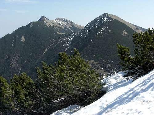 Bischof as seen from upper Kuhflucht trail (04/2011)
 Bischof as seen from upper Esterbergalm trail (04/2011)
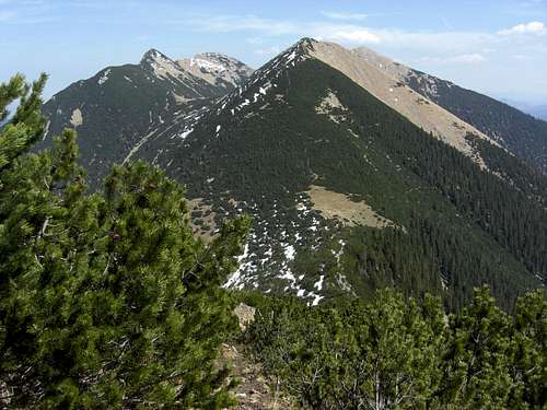 Bischof as seen from Hoher Fricken(04/2011)