
|
|
Mountain/Rock |
|---|---|
|
|
37.88252°N / 107.62429°W |
|
|
Mountaineering |
|
|
Summer |
|
|
13330 ft / 4063 m |
|
|
Overview
West face, Peak 13330 ft on the right
Peak 13330 has been mentioned as a foot-note to the 13310 ft Emery Peak, but if you want to be strict about the rules, 13330 becomes the main summit and Emery just a point on its north ridge.
Peak 13330, along with Emery and Bonita (13286 ft) Peaks to the north, Velocity (13325 ft) and Storm (13487 ft) Peaks to the south, form a chain of 13ers that rise to the east of the ghost town of Gladstone in the San Juan Mountains of southwest Colorado near the town of Silverton. These mountains separate the valley of Cement Creek to the west, from Eureka Gulch to the east.
Eureka Gulch used to be a hot-bed of mining activity in the late 1800s and early 1900s. From the end of Eureka Gulch Road, Emery appears as a priminent peak but 13330 can not be seen. This may explain why Emery has been named while 13330 remains unnamed.
Peak 13330 is rarely climbed. You are sure to find solitude on this beautiful mountain.
Approaches to Peak 13330:
1) Mineehaha Basin (West)
From Minnehaha Basin, the slopes of 13330 seem to be covered with steep scree fields that are boobytrapped by bands of cliffs. You could climb Emery Peak and then hike the 0.5 mile ridgeline to 13330. This ridgeline, however, is probably made of rotten rock and might be difficult to traverse.

Ridgeline
2) McCarthy Basin (East)
On a map, the easiest way to approach 13330 seems to be via McCarthy Basin which is a branch of Eureka Gulch. I tried this route and found McCarthy Basin to be a beautiful grassy valley above the treeline. What I assumed to be the summit of 13330, proved to be a false summit around 200 ft to the east of 13330 and 50 ft lower than it. This false summit looms as a very impressive horn above the McCarthy Basin. You can easily hike up the grassy slopes to the base of the false summit where a short class 3 walk on crumbly rock will get you to the top of the false summit. Unfortunately, the false summit is a dead end for the hiker. To reach the true summit, you will have to go down a 30 ft wall made of rotten rock and then deal with more rotten rock on your way up the summit block.
The top of the false summit is a fairly small and airy spot. From the top, a small portion of your view will be blocked by the true summit but you will still see many of the landmarks of the San Juan Mountain Range such as: Uncompahgre, Sneffels, The Red Mountains, Handies, Vermilion etc.
 Horn | 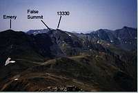 True & False Summits | 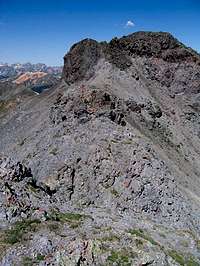 True Summit |  Horn |
3) Slagle Basin (Southeast)
a) Alternatively, from McCarthy Basin you could hike to a 12750 ft saddle and enter the upper portions of Slagle Basin to the south. This route seems to allow you to bypass the false summit.
b) This info by SP member Writhdar:
"The south ridge, which is the west wall of Slagle basin and extends from Pk 13,330 to Pk 13,229, is class 2 with an easy, short class 2+ section to the summit. This section is better & firmer than the last short section of the route to the false summit from McCarty basin. (Note that there is a higher summit just north of 13,229 - 13,229 is on the USGS topo while the other peak doesn't have an elevation - it is ~ 13,290 by GPS.)
The ridge can be attained from Slagle Basin - head for the obvious attainable saddle between 13,290 and 13,330. (Note that on the summit register, the peak is named "Proposal Peak" - details in the register.) Slagle Basin is easily reached from McCarty Basin."
 |  |  |  |  |

West face, Peak 13330 ft is the 3rd peak from right
Getting There
From Silverton, drive the right (and not the left) branch of Route 110, 8.5 miles to the ghost town of Eureka (elevation 9850 ft). Route 110 is a well-graded dirt road that is passable by any car. About 500 ft after crossing the Animas River, you will see the begining of Eureka Gulch Road to the left.Turn left onto Eureka Gulch Road (4WD recommended)and follow the road up a steep orange colored scree slope on the west side of the valley of Animas River. To the left, you will have great views of the waterfall and and the steep rocky slopes that form the east wall of the valley of Animas River.
After 0.5 miles, the road turns right and and goes into Eureka Gulch following the creek far above it. You will soon get a view of the very impressive Tower Mountain (13552 ft) and Dome Mountain (13370 ft) at the end of a valley to the left.
2.7 miles after the begining of Eureka Gulch Road (above the treeline at an elevation of 11800 ft), the road crosses to the left side of the creek. This is your trailhead. There is plenty of room to park by the road.
 |  |  |  |  |
Red Tape
No fees or permits needed for day hikes. |  | 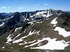 |  |
When To Climb
Easiest in summer. Eureka Gulch Road is open only in summer. For road conditions, call Silverton Chamber of Commerce (970) 387-5654. |  |  |  | 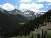 |