
|
|
Mountain/Rock |
|---|---|
|
|
43.11220°N / 42.46330°E |
|
|
Mountaineering |
|
|
12543 ft / 3823 m |
|
|
Overview
 NNW ridge of Gumachi
After some thought, I decided to put two mountains on the same page. They are very close to each other and are only separated by Opmumalniye Pass at 3780m (2B). Gumachi is a peak which is climbed a lot. It has a spectacular summit ridge and can be climbed without much experience, gear and planning. Aristova is seldom climbed even if it's close by. Probably due to some tricky traversing on rotten rock and a section with potentially dangerous corniches.
Gumachi is rated 1B to 2A and Aristova 2B according to the Russian grading system. In comparison, Elbrus is a 2A and that tells you those two peaks are a little bit harder, technically speaking, because Elbrus is higher in altitude. Gumachi is often traversed. The normal way to do it is to ascent the peak from the NE's snowy ridge and climb down on rocks to SW. The normal route on Aristova is on the SW side, which is also the same route as the common descent route on Gumachi. Some commercial climbing companies have lately started to use Gumachi as an acclimatization peak for Elbrus, even though it's located in a different part of the Caucasus. It takes 1+1 day of trekking and 1+1 hour of driving to travel in between Elbrus and Gumachi base camps. On a clear day, you'll have fantastic views of the beautiful, but evil-looking peak Ushba, the pointed Djan Tugan and the black rock pyramid Bashkara.
Getting There
 Nice trekking en route to the peak.
Most people arrive in Mineralniye Vody when going to the Caucasus. From there the most convenient mode of transport is of course to go by pre-rented mini buses, but there are also good bus connections from Min Vody, to the main valleys of the Caucasus. If going by bus, opt for one heading for Terskol or Elbrus Village. Sometimes you have to change buses on the way. Many people also hitch hike from Min Vody. Sometimes it's a free ride, but more commonly you end up going in a mini-bus where you have to pay a small fee.
When in the main valley of Elbrus, jump your transport at Camp Adil Su. There is a small camp ground, hotel, bar, shop and restaurant there. You can also put excess gear in the restaurant's "gear room for a small fee. Walk on a steep asphalt road for 4 km. At the end of the asphalt there are some good restaurants and shops. Useful for last minute shopping.
Take a left at the junction and continue along a dirt track. After another 4 km you'll hit the entrance of Adil Su National Park, where you have to register. From here on it's normal trekking to along nice streams to the base camp of Gumachi and Aristova. If you don't have a map for the area, ask for routes at the base camp. The officials staying there knows where the crevasses on route are dangerous and where the peaks are located. It may sound a bit strange, but the area are full of peaks of approx. the same height and it can be tricky to locate the one you wanna climb.
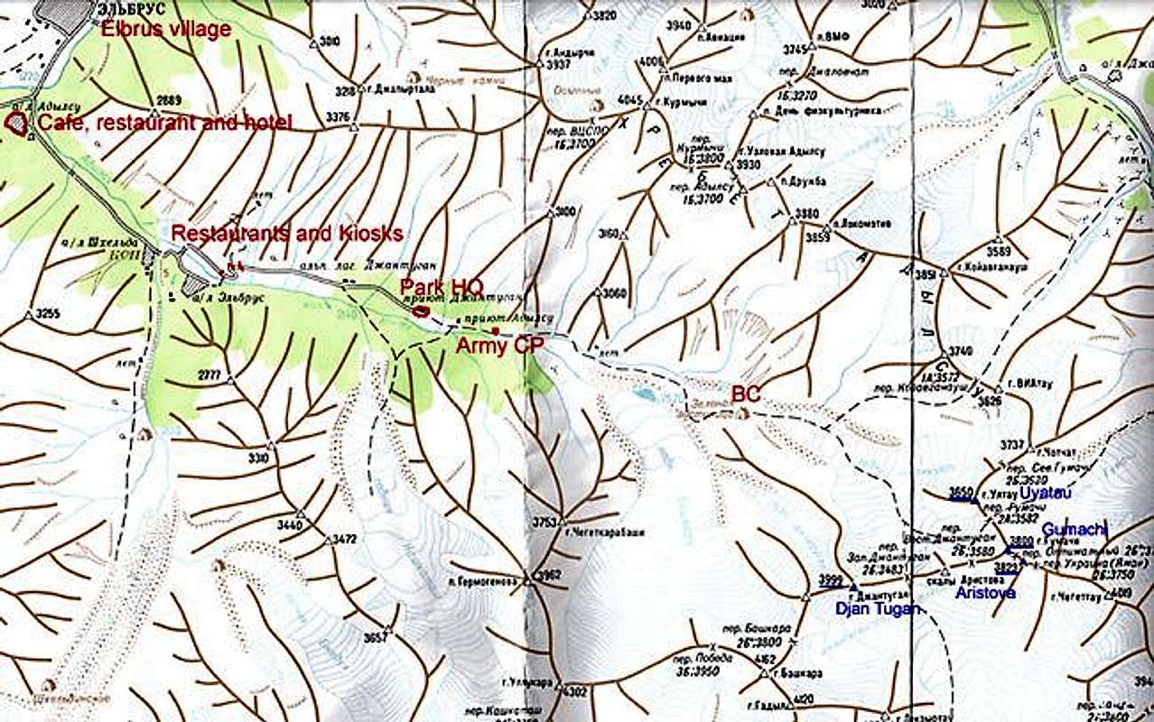
A map of the area. It may be a bit hard to read. Large version here!
Panorama
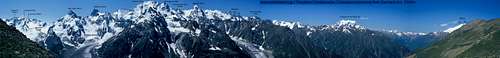 Panorama shot of the Elbrus and Adil Su area
Note: The peak called Trapezium on the image also goes under the Uyatau
Red Tape
 Rock section below the summit of Gumachi
The fee of entering Adil Su National Park is at the time writing € 0.6/day and it's payable in Russian rubles at the entrance of the park.
You have to have "Adil Su" written on your visa invitation to Russia or the military will not let you pass the checkpoint in Adil Su Border area. The army checkpoint is located roughly one km after the entrance of the park.
There are no peak fees.
When To Climb
 "Green Hotel" Camp a couple of hours from Gumachi
The best season is May to September, but the peaks are climbed in all seasons. Winter or off-season climbs reduce the rock fall and crevasse danger which is a potentially a hazard on the approach to the mountains.
The snow conditions can be very soft in the warmer months.
Camping
 A Thor. Many of these nice animals in the area.
Camping is allowed everywhere in the natural park. No fees. There are basic huts in the base camp, but they are in general used for either the rangers or persons who for one or the other reason need to stay inside a hut, i.e. have had an accident or are in a bad condition somehow. Be sure to bring down all the garbage to the park gates. I saw trekkers and climbers dumping the lot in the growing piles close to the base camp field. If someone starts doing this, it seems like the piles are growing.
Mountain Conditions
 Summit ridge - Aristova
The locals in the area seems to be very updated on the conditions higher up in the valleys and the administrative people staying in base camp have all the information you need about the conditions on the mountain. The army guys at the checkpoint and the park hq staff also seemed knowledgeable.
Routes
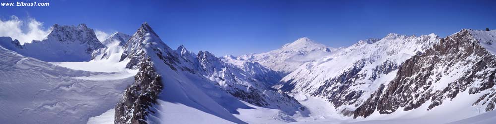
 Overview of the area.
There are many choices to reach the mountains and the best is to ask base camp adm. for advice about the crevasse situation at the time. The normal route to the mountain is either on the moraine below the glacier or on the right hand ridge above it. You'll end up on the lower reaches of Djan Kuat glacier anyway and those two alternatives are at the same level of difficulty.
Walk slightly to your left and half-circle around Peak Skaliye. Watch out for hidden crevasses. If you wanna attempt the normal route, walk /climb up to the easy Gumachi Pass at 3582m (2A). Some 40 degree snowslopes will take you to the beginning of the Gumachi summit ridge. If you haven't roped up yet, better do it here. The ridge can be prone to corniche building so walk carefully. Even if it´s not a steep ascent and not more than an easy walk, the ridge is quite narrow and if you fall on either side, it´s a long way down.
When on the summit, you'll find the peculiar "stake of Gumachi". Someone (Germans according to the base camp people) have brought cement and a 2 meter long aluminum stake to the summit and attached it in a solid way.
A more interesting way to descent the peak is to traverse down on the SW side. First you have to negotiate a section of easy rockclimbing to arrive at the Opmumalniye Pass. Climb down the 40 degree slope towards the huge snowfield. This slope is sometimes used for training self arrest and it's perfect for it.
Walk to the right of the snow field and over a small rocky ridge in order to get down to the glaciers again.
Safety
 River crossing en route
The Adil Su valley is very safe and is under strict control of the army. You are very close to the Georgian border and don't stray to far south. You will end up in hassle if caught or even seen by people "from the other side".
Video
Snow surfing down Gumachi from Janne Corax on Vimeo.
One way to get down from the saddle of Aristova and Gumachi.
Quite challenging and fast the first 40-45 degree parts.
Yihaa!
The video is very short and shot by a digital still camera, so don't expect too much.
The Book
Kopylov, the person who really knows the mountains of the Caucasus has written a book called Forbidden Mountains - The most beautiful Mountains of Russia and Central Asia.
Gear Shop
 Summit of Gumachi seen from NNW
There's a great gear shop very close to the tunr off to the Adil Su valley. It's located along the main road in the Terskol Valley. I think it's called "Alp Industria".
You can find basically everything you'll need here to very affordable prices.
External Links
of the area around Gumachi and Aristova.
Some specific info on Gumachi and great photos.