

-
 80409 Hits
-
 80.41% Score
-
 13 Votes
|
|
Route |
|---|---|
|
|
45.37384°N / 121.70177°W |
|
|
Download GPX » View Route on Map |
|
|
Hiking, Mountaineering |
|
|
Spring, Winter |
|
|
A long day |
|
|
Alpine II |
|
|
II |
|
|
Overview
The Leuthhold Couloir is located on the West Face of Mount Hood. This is a high quality intermediate route with steep snow climbing. The route crosses over the Reid Glacier making both crevasse rescue and ice axe skills mandatory. The views on the Leuthhold are quite good including Illumination Rock, the Reid Headwall, Yucum Ridge, Crater Rock, the Hogsback and more.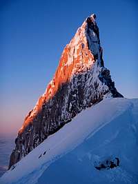 Illumination Rock |  Leuthold Couloir | 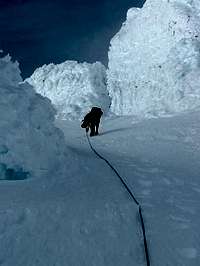 Heading up the Crux | 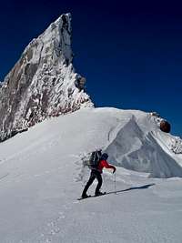 At Illumination Saddle |  On the Reid Glacier |
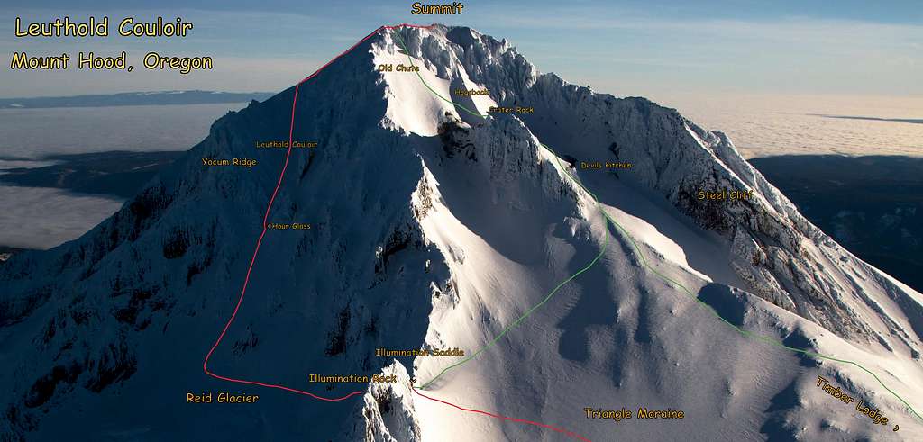
Southwest Side of Mount Hood with the Standard Route and the Leuthold Couloir
Getting There
View Google Maps Directions here. [63 Miles | 1 Hour & 27 Minutes]Getting There from Portland: From I-5 take exit onto I-84 east for 12.8 miles. Take a right at exit 16 onto 238th Dr. Continue on NE 242nd Dr (road changes name). At about 3.4 miles from I-84 turn left onto E Powell Boulevard. This road turns into US-26 E/Mt Hood Hwy. In 38.9 miles turn left onto Timberline Highway. This will take you all the way to the Timber Lodge parking lot (end of the road) which is the starting spot for this route.
Route Description
From Timber Lodge Parking lot head over towards the Timber Lodge. At the lodge head north towards Mount Hood. Depending on the time of year you may see ski trails. If they exist, go to the right of them where a climber trail should appear. This is to avoid climbers walking along the ski runs when it's in season. But if the lifts aren't open, follow the lifts. After about 2 miles you arrive at the top of the ski lifts at about 8,500 feet in elevation.Once past the ski lifts, start making an upward traverse towards Illumination Saddle (north, lightly west). Crossing the Triangle Moraine is pretty straight forward and easy.
At Illumination Saddle rope up for the Reid Glacier. Descend a small distance to make traveling to the Leuthold Couloir easier. Traverse directly north toward Yucum Ridge but not quite going to the ridge. Along the way you pass the Reid Glacier Headwall.
This traverse can be quite steep depending on the snow conditions that year. Above are several tempting couloirs. They are steeper than Leuthold, and some end up among the castle crags, which is difficult.
Keep traversing until the last big coulior before Yocum Ridge. Right away the coulior narrows and steepens. This is the hourglass, and the most likely place to get nailed by rockfall. Sprint through this short section. The slope is less steep, and the couloir widens after the hourglass is passed.
From here, stay in the biggest coulior, DO NOT TURN LEFT. You'll end up in a dead end coulior on Yocum Ridge. The coulior ends at a shoulder, and you're on the summit ridge. Turn right, and follow the ridge to the summit. The ridge has nice exposure, but isn't too narrow.
Once on the summit, descend the standard south side route.
Video
Leuthold Couloir Climbing Video Created by Gimpilator
Topographic Maps
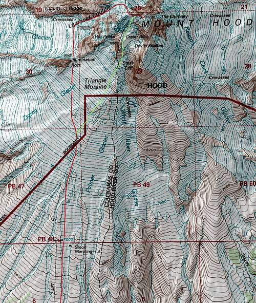
Topographic Map of the Route with Route Lines
Red Tape
A wilderness permit is required for climbing Mount Hood. They are free and are available at the Wy'East Timberline lodge.Gear for the Climb

Hiking with Overnight Gear
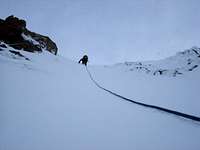
Roped up on the Climb

Ice Axe, Helmet, and Gloves

Bring a Shovel

Stay Warm
Mandatory Gear for the Climb:
- Ice Axe
- Crampons
- Helmet
- Rope
- Glacier Rescue Gear (prusiks, carabiners, webbing, ect.)
- 2 Snow Pickets (for standard glacier travel)
- Shell Jacket
- 2-3 Liters of Water Per Person
- First Aid Kit
- Glacier Glasses/Goggles
- Full Scale Mountaineering Boots (or plastics)
- Plenty of Food
Recommended Extras:
- Nylon Shell Pants
- Sun Screen
- Map and Compass
- Long and Short Sleeve Shirt
Overnight Gear:
- Tent/Bivy
- Sleeping Bag
- Ground Pad
- Stove, Fuel, Pot, and utensils (for cooking)
Optional Gear:
- Ice Tool (Recommended when icy)
- Camera
- Tooth Brush and Paste
- Toilet Paper/Blue Bag
- Trekking Poles
- GPS
I suppose it may be possible during very icy conditions to need a few ice screws. But typically folks don't bring them for this route. An ice tool however may come in handy during the winter months. I know I was very happy to have brought it.