Overview
![Ranisava & Valovito Jezero]() Ranisava (2084 m) & Valovito Jezero lake in Pošćenska Dolina valley
Ranisava (2084 m) & Valovito Jezero lake in Pošćenska Dolina valley
Going to Sedlo (1907 m) pass from Virak village you can notice one beautiful peak on the left side. That is
Ranisava (2084 m) peak, one of the 48 peaks of
DURMITOR which is higher than 2000 m. Ranisava dominate above the green
Pošćenska Dolina valley which stretches from Stožina peak to Sedlo pass. Northern side of Ranisava is most impressive and vertically stay above the blue watter of Modro Jezero (Blue Lake), which is placed below the Ranisava.
![North Face of Ranisava]() North Face of Ranisava (2084 m)
North Face of Ranisava (2084 m)![Paradise of South Durmitor]() Ranisava in winter
Ranisava in winter![Ranisava]() Ranisava
RanisavaSurroundings of Ranisava is very beautiful, there is placed four lakes, actually three lakes and one puddle - Modro Jezero lake, Srablje Jezero lake, Valovito Jezero lake and Suva Lokva puddle.
Modro Jezero lake is placed 800 m far from the road Žabljak-Sedlo-Trsa. Modro Jezero lake is situated 11 km from Žabljak town. Its altitude is 1609 m, the surface is 7300 square meters. Modro Jezero is 230 m long, while its deepest part is 80 m wide. Maximum depth of the lake is 3,3 m. Mostly, the depth of the lake is 1m, while below the rocky Ranisava peak the depth is 2m - 2,7 m. After that its wide goes to 130 m in west direction. Its coast is long between 630 m and 700 m and is mostly stable during the year, without any decreasing and increasing of water level. The wildest part of lake is on its southern side, below the rocky massif of Ranisava peak.
Srablje Jezero lake is not so large, it is 35 m long, 45 m wide and 1,5 m deep. Its altitude is 1623 m, 14m higher than Modro Jezero lake. The colour of its water is white-green. Old Durmitorians says that the water of this lake can help those who has some skin diseases.
![Durmitor]() Pošćenska Dolina valley
Pošćenska Dolina valley
Valovito Jezero lake is placed in Poščenska Dolina valley, near the Žabljak-Sedlo-Trsa road (about 300 m from the road), from where is nicelly visible. That lake with its ellipse form is situated 13 km from Žabljak town, 1,2 km from Modro Jezero lake, 3,6 km from Pošćensko Jezero lake and 1,2 km from Sedlo (1907 m) pass. The altitude of Valovito Jezero is 1695 m, it is 225 m long, 85 m wide (approximatelly width is 46 m) and approximatelly 0,9 m deep. The surface of the lake is 11.600 square meters, while its ground surface is 12.210 square meters. The coastline is 610 m long in summer time.
![Ranisava & Suva Lokva]() Ranisava (2084 m) & Suva Lokva puddle
Ranisava (2084 m) & Suva Lokva puddleSuva Lokva puddle is placed in Pošćenska Dolina valley, between Međugorje and Stožina peak. That puddle is nicelly visible from the road Žabljak-Sedlo-Trsa. The altitute of Suva Lokva is 1594 m. Suva Lokva is placed 1,8 km far from Pošćensko Jezero lake and 700 m from Modro Jezero lake. That puddle is 400 m long, 90 m wide and 1m deep. In the spring time Suva Lokva puddle looks like a big lake.
Summit View
![Ranisava & Pošćenska Dolina]() Pošćenska Dolina valley - Ranisava (2084 m), Sedlena Greda (2227 m) and Stožina (1908 m)
Pošćenska Dolina valley - Ranisava (2084 m), Sedlena Greda (2227 m) and Stožina (1908 m)
From the summit of Ranisava (2084 m) you can enjoy in beautifully summit panoramas:
E: MORAČKE PLANINE range, Riblje Jezero lake, Vražje Jezero lake
NE: Stožina (1908 m)
N: Šljeme (2455 m), Uvita Greda, Valovito Jezero lake
W: Sedlena Greda (2227 m), Sedlo Pass (1907 m)
![Moracke Planine]() Eestern view to MORAČKE PLANINE range
Eestern view to MORAČKE PLANINE rangeGetting There
![Ranisava]() Ranisava from the entrance of Pošćenska Dolina valley
Ranisava from the entrance of Pošćenska Dolina valleyGateway to Durmitor National Park and Ranisava (2084 m) peak is Zabljak (1456 m) town, precisely a Poščenska Dolina vallez near the Sedlo (1907 m) pass. Information how to get there:
By Plane
~To
Beograd (Belgrade, Serbia&Montenegro capital) airport. Than with plane to Podgorica, capital of Montenegro, or with bus or car to Zabljak town.
~To
Podgorica airport. Than with bus or car to Zabljak town.
Information about flights find on the sites of
JAT Airways, a former Yugoslav airlines, or on
Montenegro Airlines.
By Bus
~
Beograd (Belgrade)-Zabljak
~
Podgorica-Zabljak
~Niksic-Zabljak
~Pljevlja-Zabljak
Buses go to Zabljak from Beograd (Belgrade) twice a day and from Podgorica, Niksic, Pljevlja and Mojkovac several times per day.
By Car
~
Beograd (Belgrade)-Zlatibor-Nova Varos-Prijepolje-Pljevlja-Zabljak
~Niksic - Savnik (47km) - Zabljak (37km): 84km; Niksic to Zabljak approach from south.
~Niksic - Savnik (35km) - Zabljak (37km): 72km;
~Podgorica - Niksic (55 km)-Savnik (47 km)-Zabljak (37 km): 139 km; Add this length if you are going to Zabljak from Podgorica via Niksic. Road to Niksic from Podgorica is good.
~Podgorica - Kolasin (71km) - Mojkovac (21km) - Zabljak (67km): 159km; road is good all the way to Zabljak. Behind Podgorica (56m) you go inside Moraca River canyon (one of spectacular Montenegrin canyons). It is up to 1000m deep and has wild sides. That's spectacular drive. After that, from "Djurdjevica Tara" bridge to Zabljak - 23 km.
Than from Zabljak town to Sedlo (1907 m) pass by Zabljak-Virak-Trsa road, 16 km from Zabljak town. From Sedlo pass the path road continue to Dobri Do or finally to Todorov Do cirque.
Camping
![Ranisava]() Ranisava from Pošćenska Dolina valley
Ranisava from Pošćenska Dolina valley
Camping permitted on camping dedicated spots only. Major huts are in good condition, but with no service. Still, open to the general public. Hikers/climbers are supposed to bring all the jummy stuff with them.
The best place for camping before the climbing of Ranisava peak is Pošćenska Dolina valley and its grassy plateau.
Maps & Guides
![Map of Durmitor National Park...]() Durmitor Map
Durmitor MapExist three maps of Durmitor:
1. Map of Durmitor Massif & Tara Canyon - 1:25000. Author: Branislav Cerovic. You can buy it in Zabljak town in almost every store. Price: 5-6 euro.
2. Map of Durmitor National Park & Tara Canyon - 1:25000. Author: Branislav Cerovic. You can buy it in Beograd (Belgrade, Serbia) in Geokarta Co, Belgrade. Price: 2 euro. This map is better than first one and include many informations and facts about routes, peaks, lakes, glacial cirques, valleys, canyons,...
3. Durmitor Mountain Guide & Map. Short mountain guide with some basic informations and facts. Author of map: Pavle S. Bandovic. Editor: "Summit" Travel Agency, Zabljak, 2005. Price of Guide&Map: 7 euro.
Weather Conditions
The best weather forecast on Internet for Durmitor (Zabljak town) and Ranisava (2084 m) is
VREME YUBC NET site. You can see 5 days forecast for Durmitor area, 4-times-daily forecast.
Red Tape
No extra fees.

 Ranisava (2084 m) & Valovito Jezero lake in Pošćenska Dolina valley
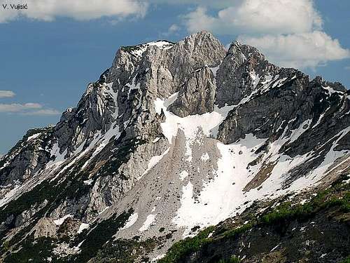 North Face of Ranisava (2084 m)
 Ranisava in winter
 Ranisava
 Pošćenska Dolina valley
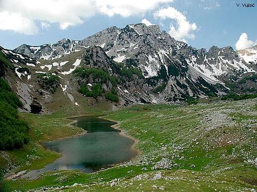 Ranisava (2084 m) & Suva Lokva puddle
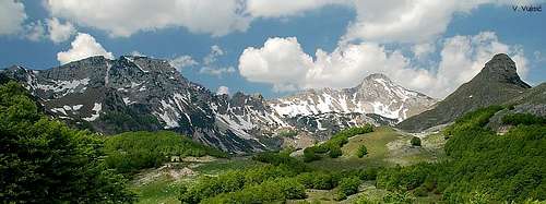 Pošćenska Dolina valley - Ranisava (2084 m), Sedlena Greda (2227 m) and Stožina (1908 m)
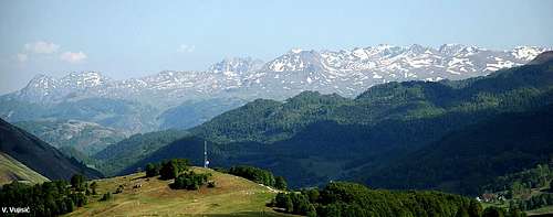 Eestern view to MORAČKE PLANINE range
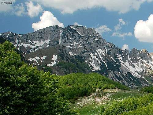 Ranisava from the entrance of Pošćenska Dolina valley
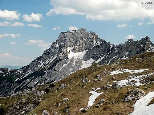 Ranisava from Pošćenska Dolina valley
 Durmitor Map