
|
|
Mountain/Rock |
|---|---|
|
|
40.67790°N / 111.0612°W |
|
|
Summit |
|
|
Hiking, Mountaineering, Scrambling, Skiing |
|
|
Spring, Summer, Fall, Winter |
|
|
10887 ft / 3318 m |
|
|
Overview
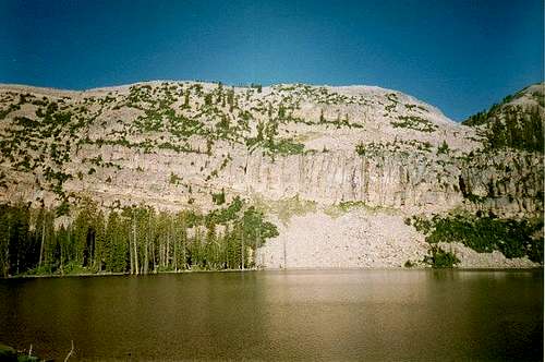
Wall Peak (Wall Benchmark) is a relatively obscure and ignored peak located in the far western section of the Uinta Mountains. The mountains in this section of the Uintas are not as high as the ones to the east. Never the less, the peaks in the area are good climbing objectives in a beautiful area. The peak is certainly very conspicuous when viewed from Big Elk Lake which is located to the east.Although the peak is somewhat minor it certainly has enough "elevation prominence" to be considered individual peaks. Wall Peak has 530 feet prominence above the connecting ridge to Peak 10,931. The peak is surrounded by many spectacular and fish-filled lakes, and is a nice scrambles with great views.
It can be climbed on a day trip, but the area is surrounded by many nice backcountry campsites in the basins and around the fishing lakes.
The Uinta Mountains are one of the few mountain ranges in North America that run east to west rather than north to south. Within the Uinta Mountains are about 2000 lakes, and some 900-1000 are full of trout. Along with the San Juan Mountains in Colorado, the Uinta Mountains have more contiguous area above timberline than any other area in the Continental United States. This is a beautiful area with many lakes, meadows, wildflowers, and some rugged peaks. Solitude is usually easy to come by once you leave the popular fishing holes behind.
The Uinta Mountains are very rugged in the northeast section. Beginning at Hayden Peak and east to Mount Lovenia, the Uinta Mountains are not unlike the Tetons or other ranges. East of Lovenia, the peaks are more gentle, with a few rugged peaks (i.e. Red Castle and Henrys Fork Peak) scattered about until you are as far east as the Henrys Fork/Kings Peak area. East of Kings Peak, the Uinta Mountains become very gentle and the peaks are very rounded with only a few scattered cliffs about.
This is a beautiful area with many lakes, meadows, wildflowers, and some rugged peaks. Solitude is usually easy to come by once you leave the popular fishing holes behind.
 Ridge south of Wall Peak, marked 10,717 on the topo. Shouler of Wall Peak is to the right.
Getting There
Upper Setting TrailheadThe Upper Setting Road takes of north off Highway 150 8.7 miles east of Kamas. The lower section of this gravel road is good for passenger cars, but the upper half of the road is suitable only to high clearence vehicles. There are many side tracks, but follow the main track to its end.
Shingle Creek Trailhead
The trailhead is at a signed parking lot located on the north side of Highway 150 10.1 miles east of Kamas.
Norway Flats Trailhead
The Norway Flats Road branches off the north side of Highway 150, 10.6 miles east of Kamas. There is a sign marking the road. The road is good for the first mile, and then it quickly deteriorates into a 4wd road. Follow the 4wd road north staying on the main road that is marked for 4wd's (staying away from the forks marked for ATV use). Near the end of the main road there is a junction. Turn right along a less used road and follow the road to its end. If you reach a large lake, you're in the wrong place. Turn around and backtrack a short distance to the last junction and follow the less used road to its end. At the end of the road is a vehicle barrier trench and a signpost without a sign (late 1990's). This old blocked off road is the beginning of the trail.
Crystal Lake Trailhead
Crystal Lake is reached from the Trial Lake spur road off Highway 150 25.7 miles east and north of Kamas. Follow the signs along the spur road to Crystal Lake. This gravel road is good for all vehicles.
Smith and Morehouse Trailhead
The trailhead is at the Ledge Fork Campground. From Oakley (State Route 32), turn east on the Weber Canyon Road. Follow this road east for about 12 miles to where the Smith and Morehouse Road turns south. Turn right (south) at this junction and follow this good gravel road past the Smith and Morehouse Reservior. The road ends at the Ledge Fork Campground and the trailhead.
 Descent from Norway Ridge into the saddle separating it from Wall Peak
Routes Overview
Upper Setting RouteThis route begins at the East Upper Setting Trailhead, follows the trail to West Shingle Creek Lake, over a low pass to Erickson Basin, to Big Elk Pass, and either along the ridge south to the summit of Wall Peak.
 South Erickson Lake. The north slopes of Wall Peak are to the right.
Shingle Creek Route
This is a longer variation of the Upper Setting Route, but the road to the trailhead is good for all vehicles. If you drive a passenger car, and don't want to walk any access roads, you will have the choice between this route and the Crystal Lake Route. The trail joins up with the Upper Setting Route near West Shingle Creek Lake.
Norway Flats Route
This is the by far the shortest route to Wall Peak and Peak 10,931. The trail heads north to Big Elk Lake, at which point it climbs to or near Big Elk Pass. There are two route variations that will be described for Wall Peak from near the pass.
 East Face of Wall Peak in winter.
Crystal Lake Route
This is the route from the east. From Crystal Lake, the trail heads west over Watson Pass, west to Long Lake, west to Island Lake, and West to Big Elk Lake where the route will join the Norway Flats Route. This is a long route, but is highly scenic and the road is good for all vehicles.
Smith and Morehouse/Erickson Creek Route
This is a route from the north. It is a highly scenic route. The route follows the main Smith and Morehouse Trail to the Erickson Creek/Basin cutoff. The route then follows the trail up Erickson Basin and then east to Big Elk Pass (see above).
 The upper Smith and Morehouse Basin enroute to Wall Peak.
Guidebook Available
More details about the area can be found in the book Western Uinta Backcountry Guide, including many routes to the summit, and hiking trails to the many lakes, and fishing information. Just send me a PM if you want to purchase the book.SP members can have the book for 1/2 price, and there is no shipping cost.
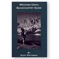 Guidebook
Red Tape
For the southern routes (all trailheads above, except for the Smith and Morehouse Trailhead), and for traveling Highway 150, there is now a $3 per day use fee for parking along the highway. There is no red tape for the Smith and Morehouse Trailhead.When To Climb
July through September is the normal hiking season here. All trailhead roads above are closed in winter, except for the Shingle Creek Trailhead.The best route in winter might be to snowshoe or ski up the Norway Flats road from Highway 150. In winter, the round trip distance via the Norway Flats Route would be about 20 miles for either peak, making it a two day trip. If you want to climb both peaks in winter, consider taking three days.
 Norway Ridge in winter.
Camping
There are many campgrounds along Highway 150, but they can be crowded and full on summer weekends. There is also a campground at Smith and Morehouse Reservoir. In addition to campgrounds, there are several primitive camping sites on each route described below.Upper Setting Route
There are campsites along the Upper Setting Road. In the backcounrty, there are some good campsites along the way to East Shingle Creek Lake and near a lily pad pond. There are good campsites at East Shingle Creek Lake. Erickson Basin has many really good campsites.
Shingle Creek Route
Excellent campsites are located most of this trail.
Norway Flats Route
There are some campsites along the Norway Flats Road. Good campsites are found along the trail and in the meadow .5 miles from the trailhead. BIg Elk Lake has some campsites on it's southwest and east sides.
Crystal Lake Route
There are many good backcountry campsites throughout the area. Long Lake campsites are a bit over-used, so you may want to look elsewhere. Island Lake is very popular as well, and can be crowded. Big Elk Lake is my favorite site along the route (see above).
Smith and Morehouse/Erickson Basin Route
Large campsites are a bit scarce on the lower section of the trail. Erickson Basin has many good campsites.
Mountain Conditions
Contact the ranger station in Kamas for current road and trail conditions. Their phone number is 801-783-4338.WEATHER FORECAST FOR WESTERN UINTA MOUNTAINS
Here are some average highs and lows from Mirror Lake at 10,190 feet :
| MONTH | HIGH | LOW |
| JAN | 23 | 0 |
| FEB | 25 | 2 |
| MAR | 29 | 6 |
| APR | 38 | 14 |
| MAY | 47 | 22 |
| JUN | 57 | 31 |
| JUL | 67 | 38 |
| AUG | 65 | 37 |
| SEP | 57 | 30 |
| OCT | 46 | 19 |
| NOV | 32 | 10 |
| DEC | 26 | 4 |