
-
 17268 Hits
-
 87.31% Score
-
 24 Votes
|
|
Mountain/Rock |
|---|---|
|
|
37.93780°N / 107.2678°W |
|
|
Hinsdale |
|
|
Hiking |
|
|
Spring, Summer, Fall, Winter |
|
|
12305 ft / 3751 m |
|
|
Overview
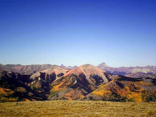 Red Mountain at center stage in the westward views from 71 Mountain.
The generally north-south running Continental Divide of North America takes a swooping westward turn in southwestern Colorado. Included in this westward bulge of the Divide is the oddly-named 71 Mountain. 71 Mountain sits on the western edge of a high plateau jutting up above the Lake Fork of the Gunnison River. Relatively dramatic when viewed from the west, from the east, 71 Mountain appears to be a gentle hill rising from Rambouilette Park (locally pronounced ram-boo-lay).
71 Mountain hosts a microwave repeater tower and the means to generate power for the repeater, including a wind turbine and solar panels. While not a particularly bold or rugged peak, the summit of 71 Mountain provides the visitor with truly jaw-dropping views. To the west, three nearby Fourteeners are visible: Handies, Sunshine & Redcloud, with Uncompahgre and the Wetterhorn visible in the distance. Colorful Red Mountain and neighboring Grassy Mountain are nearby. Lake San Cristobal, Colorado’s second largest natural lake, blazes brilliant blue in the Lake Fork Valley. Geological curiosity Slumgullion Slide, which formed Lake San Cristobal several hundred years ago by damming the flow of the Lake Fork, intrigues the viewer. Eastward views of high alpine parks and mesas, against a backdrop of almost never-ending mountains, encourage long, leisurely visits to this peak.
Colorado Rank: 1137th highest peak in Colorado
Prominence: 524 feet
USGS Quad: Lake San Cristobal
Trails Illustrated Maps: #139 La Garita / Cochetopa Hills and #141 Silverton / Ouray / Lake City
Rank and Prominence Information: Lists of John
Getting There
 Easy section of Jeep Road
71 Mountain is located in Hinsdale County, which promotes itself as the most remote county in the lower 48 United States. 71 Mountain rises to the southeast of Lake City, Colorado. The primary highway cutting through this region is CO 149.
To reach the high plateau which 71 Mountain is a part of requires either a stout 4x4 or all day on strong legs. Having driven two of the three primary Jeep trails accessing this plateau, I assure you that, should you choose to drive up the plateau, you will find the drive most pleasant if your vehicle has high clearance, multi-ply hybrid or off-road tires, and a creepy low-end gear ratio. Alternatives to jeeping would include: Hiking or cross-country skiing (winter), mountain biking (comfortable on steep terrain covered in “baby head” boulders) or an ATV or snow machine (winter).
This map on the Lake City website provides a great reference for the general location of this mountain.
Stay tuned for the “Service Road Route” and information on primary approaches to this route!
Red Tape
There is very little red tape in this part of the Rio Grande National Forest. There are no fees to use the area. Grassy Mountain, UN 13,832 & UN 13,811, Redcloud, Sunshine and Handies
Identified from right foreground to left background
Camping & Lodging
 Aspen coating the Slumgullion Slide
  Red Mountain and Uncompahgre
 South from the summit
 Summit Repeater
 South-southwest from summit
 Valley of the Lake Fork of the Gunnison
Camping
To learn more about camping near Lake City, visit this informative Lake City website.
ON THE PLATEAU
Rustic Camping: Rustic camping is available all over the plateau, but water availability may be limited. Be prepared to haul in the water you need.
NEAR SLUMGULLION PASS
The Forest Service operates 4 campgrounds off of FS 788:
• Slumgullion (21 sites)
• Deer Lakes (12 sites)
• Hidden Valley (3 sites)
• Spruce (9 sites)
NEAR LAKE CITY
• National Forest Service campground: The Williams Creek Campground is just a few miles west of Lake San Cristobal on County Road 30. The campground has 23 sites for tents or RVs.
• BLM Campground: The Bureau of Land Management operates the Mill Creek Campground just a few miles west of town on County Road 30. The campground has 22 sites for tents or RVs.
• Hinsdale County Campground: The county operates the Wupperman Campground on the east shore of Lake San Cristobal.
Lodging
Lodges, Motels, B&Bs, Cabins, Dude Ranches and Developed Campgrounds
Lake City hosts a plethora of lodging solutions to fit wide variety of tastes & budgets. Visit the Lake City visitor’s website for details on lodging.
Weather & Seasons
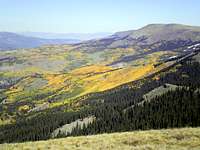
• Fall, when the aspen trees glow bright golden to orange and red, is a delightful time to visit 71 Mountain. • In the Summer, the peak would be easily accessible, though crowds could be an issue as the Lake City area is popular with both in-state and out-of-state tourists. • The snowpack in Winter or Spring could make for an arduous, on-foot access via snowshoes or skis, and the temperamental Colorado snowpack should always be treated with suspicion. Jeepers should avoid boggy areas during snowmelt to avoid further damage to sensitive high bogs and grasslands. |