
-
 12114 Hits
-
 80.84% Score
-
 13 Votes
|
|
Mountain/Rock |
|---|---|
|
|
49.10350°N / 7.53730°E |
|
|
Hiking, Sport Climbing, Bouldering |
|
|
Spring, Summer, Fall, Winter |
|
|
377 ft / 115 m |
|
|
Overview
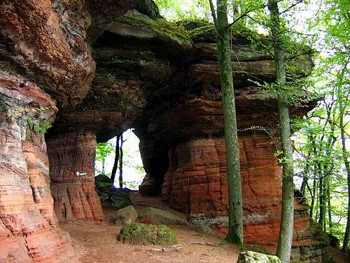 One of the many rock cave windows of Altschloßfelsen One of the many rock cave windows of Altschloßfelsen |
Altschlossfelsen - which would translate into "old castle rock" - is hidden deeply inside the forest of Pfälzerwald, almost directly on the German / French border. The hideout is so perfect that when I first went there I was about to turn around right before I reached the crags. Though not really long the access route is remote - you have to drive for ages along small side roads to get to the parking lot before you set out for the remaining 4km to Altschlossfelsen. Impatience might be rising (as it within myself) as the dense forest will cover any possible view, especially in the spring and summer months.
Still I would advise anyone who is interested to go there in the spring months. The colour contrast between the red sandstone rocks and the surrounding brightly green beech and birch forest is just too striking to miss. You come up to crag quite suddenly (thanks to the trees and leaves) and then you'll be awed. Huge house sized red boulders loom up above you forming huge dark grey overhangs for the mushroom caps. There is a path which leads you to the top of the interconnected mushrooms but think twice before you head up there. From atop you only get rare glimpses of the crags and you might think you are trudging along a regular forest path.
So I'd advise you to stay down at the base and explore the ridge from below. You'll run into numerous caves and rock windows, the former at the southern, the latter at the northern end of the ridge. There are several spots among the ridge which have been climbed but those climbs are rarely done, mostly because of the long access and the short, one or two pitch routes. The crags rather qualify as bouldering destination. The following table links to the route database of the Vereinigung der Pfälzer Kletterer, the local (very well organized) climbing association.
| Region | Routes link | Summary |
| Eppenbrunner Turm | Eppenbrunner Turm | 4 routes with variations ranging from 3- - 7 |
| Wilhelmturm | Wilhelmturm | 3 routes up to grade 6 |
| Ottoturm | Ottoturm | 5 Routes with variations ranging from 2 - 7 |
| Jeanturm | Jeanturm | 7 routes ranging from 2 - 9- |
| North-Eastern Massif | North-Eastern Massif | 1 route 8- |
| South-Western Massif | South-Western Massif | 7 routes ranging from 7 - 8+ |
Getting There
 Eppenbrunner Turm to the north of Altschloßfelsen
 Washed out rocks to the nort of Altschloßfelsen
From Frankfurt
There are two possible routes which both take equally long- Via Ludwigshafen
- From Frankfurt take motorway A5 southward to Darmstadt.
- There change to A67 south.
- At Viernheimer Dreieck turn onto A6 west. Leav
- e it at Frankenthaler Kreuz for A61 south.
- At Mutterstädter Kreuz take A65 south until you reach Landau.
- At Landau turn on B10 west.
- At Pirmasens turn onto L484 / L478 south which will take you to Eppenbrunn. Go through the village and in the road curve behind it leave for the parking lot at Spießweiher
- Via Kaiserslautern
- From Frankfurt take motorway A3 west
- At Mönchhofdreieck turn onto A67 south
- At Rüsselsheimer Dreieck take A60 west
- At Kreuz Mainz Süd take A63 south
- At Kreuz Kaiserslautern turn onto A6 west
- At Kreuz Landstuhl turn onto A62 south
- At Pirmasens turn onto L484 / L478 south to Eppenbrunn
From Stuttgart
- Take motorway A8 to Karlsruhe
- At Karlsruher Dreieck turn north onto A5
- Tke the next exit to head for A65
- At Landau leave for B10
- At Pirmasens go south on L484 / L478 to Eppenbrunn
From Strassbourg
- Take motorway A4 north
- At the Brumath Intersection take N340to Haguenau
- There take D27 north to the German border
- At the border the road turns into L488 to Fischbach
- There take L478 to Eppenbrunn
From Saarbrücken
- Take motorway A6 north to Homburg
- Turn onto A8 to Pirmasens
- At Pirmasens go south on L484 / L478 to Eppenbrunn
Red Tape
 Erosion structures at Altschloßfelsen
The use of magnesia is not allowed in the whole Südpfalz region. This is rather a directive or an arrangement than an outright law. Thus you probably will get away with using it but do so only when absolutely necessary. Magnesia closes the pores which you find in the sandstone and together they form a smooth surface which will get very slippery in wet conditions. The rule of thumb is to use magnesia in the highest difficulty sections and only extremely sparingly.
A list of guidelines can be found here (in German).
Accommodation
In Eppenbrunn you can find several rooms and apartments. Have a look at the tourist information site for more info. Click the "Unterkunftverzeichnis" Link in the right sidebar.Weather Conditions
The closest available weather information is the one for Pirmasens (20km to the north-west):Pirmasens weather
Maps & Books
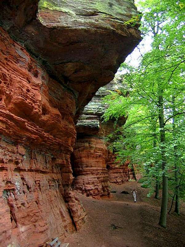 The hike around Altschloßfelsen leads you to numerous cavernous overhanging rocks
Maps
As for maps there is a good overview map (1:50000) by Kompass Verlag but the best ones are the official topographic maps by the state government of Rheinland Pfalz, scaled 1:50000, 1:25000 and 1:5000. All official maps can be found on the web page of Landesvermessungsamt Rheinland Pfalz
1:50000
- Naturpark Pfälzer Wald
Kompass Map WK766
ISBN: 3-85491-523-3
- Pirmasens Süd
LVA RLP Map L6910
ISBN: 3-89637-193-2
1:25000
Books
here are a number of climbing guidebooks on the region of Südpfalz. The best ones, however, have been published privately and are sold only in selected bookshops of the region.
- Hiking
- Pfälzerwald
B. & J.-Th. Titz
Rother Verlag
ISBN: 3-7633-4268-0 - Klettern im Buntsandstein
U. Daigger, H.-J. Cron
Published privately and out of print
- Pfalz ++, Klettern im Buntsandstein
R. Burkard, P. Weinrich
Published privately
- Klettern im Naturpark Pfälzerwald
Naturfreunde Lambrecht
Published privately - Pfalz & Nordvogesen en bloc
A. Wenner, Y. Corby, I. Bald
Panico Verlag
ISBN: 3-936740-19-4
Climbing