“Have you seen the weather forecast?” Marie asked as I walked in the door.
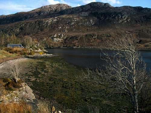
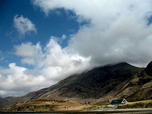
Sallachy
Indeed, I had. For the last 10 days or so, Scotland had been experiencing some good weather but as our week-long trip approached, a warning of rain coming in from the Atlantic was promised for every day!
I have been to Scotland many times but for the first time ever, we had decided to fly to Inverness from Gatwick, hire a car and after stopping for groceries, drive to Sallachy in the Lochalsh region of Scotland. This was a more expensive way to travel but it beats the 12-hour drive from the south east of England I have always done in the past.
We arrived on Saturday afternoon in glorious weather, knowing it had been like that for a couple of weeks and that the next day, everything would change. So, whilst some days were spent going for a drive in the rain and watching the showers sweeping over Loch Long from our excellent rented cottage, on others we managed to get out and sample some of the area’s low-level treats.
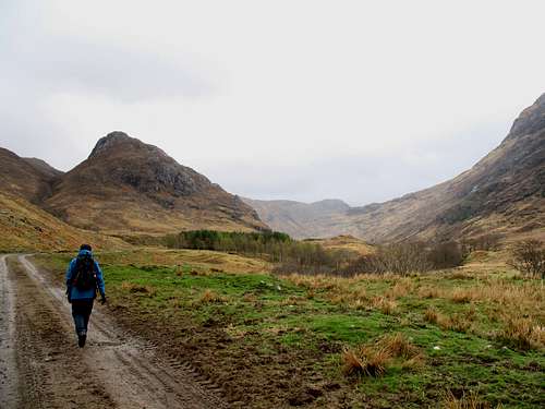
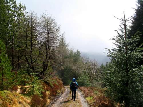
Glen Elchaig
“At least it’s stopped raining”, Marie pointed out.
That was true. It had been raining more or less non-stop since Sunday morning and now, on Monday, there was at least a “lull”.
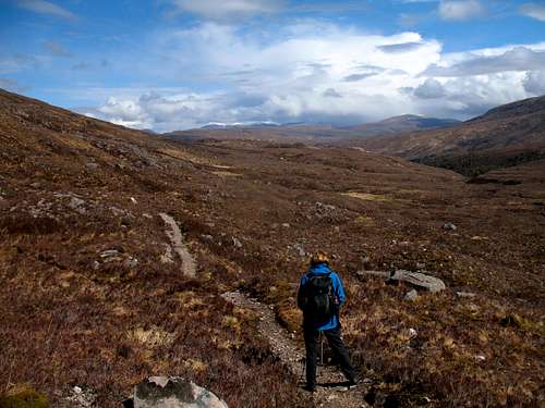
After some deliberation, we had decided to do a “short valley walk” in Glen Elchaig, starting from the car park at Killilan.
There are many routes that can be started from here from short, easy low – level walks, through ascents of Corbetts (mountains in Scotland between 2500 – 3000 ft high – 763m-914m) or Munros (mountains in Scotland over 3000ft high – 914m+) up to multi day expeditions into the wilderness areas around Loch Mullardoch and Glen Affric beyond.
Glen Elchaig
As I said, we had chosen a short valley walk, following a track running parallel to the course of the River Elchaig.
There were several reasons for choosing this:
1 – It’s a low-level route that follows the valley, so no route finding and little height gain or loss.
2 – A lot of it is on a tarmac road that turns to a good dirt track, so no bogs.
3 – I wanted to try out my new boots and if my feet hurt, it was easy to turn back.
4 – We had a vague idea of visiting the Falls of Glomach, reputed to be “… the most beautiful waterfalls in Britain.”
The forecast had promised a lull in the almost continuous rain and as that lull had seemed to have arrived, we got going.
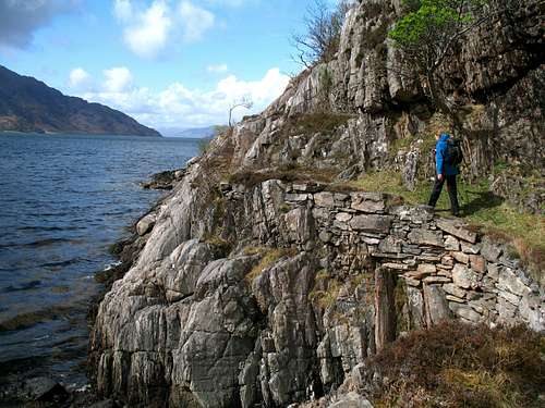
After leaving Killilan, the route passes some houses and goes through the estate farm buildings continuing parallel to the River Elchaig. There is a car park at Camus – Lunie on the opposite side of the river which cuts out the need for some of this road walking but the description we had from here hinted at possible route-finding problems and with all the rain, a lot of the surrounding fields were looking a bit wet and boggy.
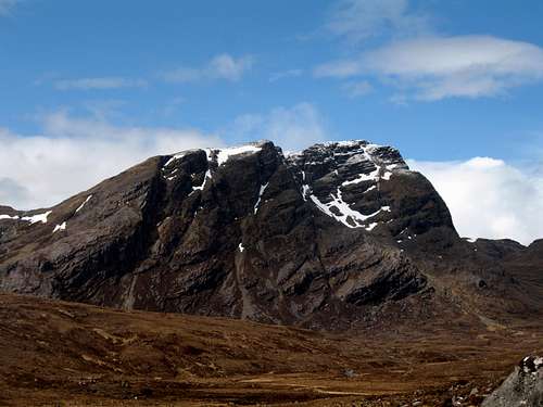
Sgumann Coinntich (879m) (a Corbett) and Ben Killilan (757m) rise above the road on our left but they rarely came out of the clouds which swept in from the Atlantic. Occasionally, I looked wistfully upwards to their hillsides but the gloomy clouds crossing them convinced me that being lower was better.
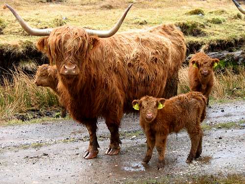
We continued on our track with only a few puddles to avoid until up ahead, we could see an obstacle….a herd of Highland Cattle.
At this time of the year there were several young calves standing close to their mothers who stared at us intently through their long hair. As we approached, none of them looked like they were going to move aside!
Now, I have an inherent fear of all animals so, quoting from “Raiders of the Lost Ark”, I said to Marie,
“This looks dangerous…. You go first!”
Marie rolled her eyes towards the heavens and advanced talking to the fearsome looking beasts. Having grown up on a farm, she has no such fears and I usually send her in first!
Highland cattle
The cattle let Marie walk through them, I tried to follow but they all wanted to follow her as well. Soon she was leading the herd down the track, like some sort of cattle “Pied Piper” whilst I was stuck in the middle of the herd, two sets of long horns following just behind me! It wasn’t long before I lost my nerve and jumped out of the way, over the water filled ditch, off the track and hopped from one clump of grass to another, avoiding the swamp-like mud and gradually overtaking the cows.
“What are you doing”? Marie asked from the front.
Made it! I was back on the track at the front, the cattle looked on, I fancied I saw a bemused look on their faces!
We continued walking and gradually drew away from the cattle who seemed to get bored with following us, it started to rain and this worsened until it was a persistent shower, luckily it was sweeping in from behind us so although our backs got wet, our fronts stayed relatively dry! With the rain, we retreated into our own gore - tex covered worlds for a while.
Eventually, the rain stopped and we had reached the point where the map shows a path to the right, leading across the river towards the fabled Falls of Glomach. The ground off the main track was a complete quagmire. Pools of dark water lay amongst the sodden, boggy ground. We stared at it in dismay.
“Where do you think the path is?”, I asked.
“I think that’s it…” Marie replied pointing to the soaked mud. “I’m not going down there!”
“Good idea!”
We found a place to sit by the side of the track to eat lunch and contemplate our next move. I got the map out.
“There’s the footbridge over the river. The path must be down there somewhere… and then over the flood plain and up there.” I pointed to the small hills on the other side of the river.
“Yes, there’s someone walking”, Marie said.
Sure enough, we had found the route to the Falls.
“Shall we continue along the track”, Marie asked.
“Yeah, I think so!”
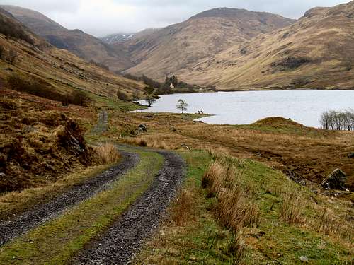
Leaving the falls for another day, we carried on over a rise, through some trees to see the view of the Loch na Leitreach.
View of Loch na Leitreach with the hamlet of Carnach beyond.
I was aware that we had been walking for more than 2 hours and it looked quite a long way on the map but I was unsure exactly how far it actually was. In the distance, we could see some small houses, shown as “Carnach” on the map but miles from anywhere.
“I can’t believe anyone lives out here”, Marie said.
The track descended towards the Loch and the distant houses, we stopped to take in the view and decided we had walked far enough. We still had to walk all the way back and had no idea if the rain, which had held off for a while, would suddenly return.
We retraced our steps from Loch na Leitreach. Walking now in to the wind, we had to concentrate on keeping up a good rhythm. We passed the Highland cattle, no longer interested in following us, we passed a newly born lamb, huddled under its mother.
Sgumann Coinntich was still hidden by low cloud as we chatted to another walker, descending on the path by the old schoolhouse.
I was starting to feel that I had walked a long way in new boots as we returned to the car, still in reasonably dry weather. It was only later I realised we had walked nearly 12 miles!
Not really an epic mountain day but not bad for brand new boots!
Corran coastal path
“It certainly looks brighter today than yesterday,” Marie commented.
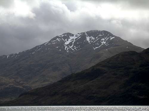
Beinn Sgritheall
As we drove over the Ratagan pass, we observed ragged holes appearing in the cloud cover, exposing blue skies above.
The weather forecast had been much the same as the previous days. The wind speed was high and the cloud cover was low, frequent showers were blowing in off the Atlantic promising a poor day on the West coast.
However, the reality was different. As we drove down the long coastal road through Glenelg, the weather even seemed to be improving.
“Maybe we should go back and do something else”? Marie continued.
I shook my head, “It’s just temporary, it will change again soon. Look at Beinn Sgritheall”
I pointed to the dominant feature in the landscape. A hillside rising steeply from the sea was lost in a thick cap of grey clouds. Even from the road we could see the clouds were being shredded as they blew across the rocky slopes but the summit stayed permanently hidden above.
I had climbed Beinn Sgritheall (974m) once before in Feb 1991, that was a grey, frigid day.
I had a distinct picture in my mind’s eye of Arnisdale where I thought we had parked on that day. So much so that I was convinced I would recognise the place when I saw it. As we drove through the small hamlet along the coast road, I realised that I didn’t recognise it at all, my memory was completely false!
Such is the frailty of memory…or is it just mine?
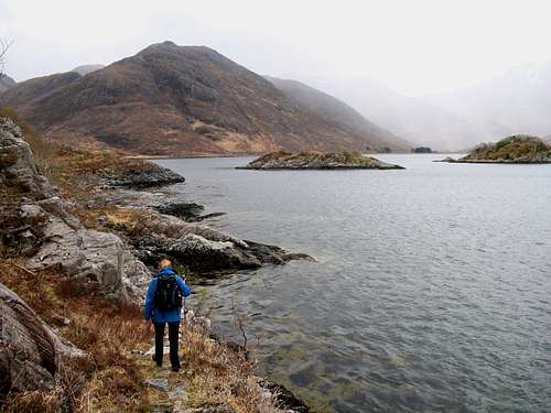
Just past Arnisdale, we reached the sign for Corran…the end of the road. We parked in the small car park on the right.
The coast walking route started by crossing the bridge to the small collection of houses, now mostly holiday rents, with their mixture of old local stone and modern whitewash outer walls.
It then passed in front of some old stone “sheds” and continued along the shore of Loch Hourn (Loch of Hell!), a sea loch. In the past, this route was said to be used by local Herring fishermen retrieving their catch, it has been restored and developed in recent years as a walker’s path.
Luinne Bheinn, Knoydart.
There’s not much to say as far as directions are concerned, about this route. It ran parallel to the loch shore. Sometimes it crossed the pebble beaches, sometimes it is almost lost as it passed over boggy ground, made worse by the countless streams trickling off the surrounding hillsides. At its best, modern interventions have created an improbable path over the steep rock slabs above the sea loch.
Having said that, it was hard going underfoot and we made slow progress.
As it was still sunny, we stopped early for lunch. We sat on some rocks in a peaceful, sheltered bay with only the smell of seaweed and the lapping of the waves to keep us company.
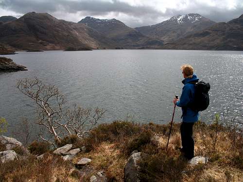
Across the loch lies the peninsular of Knoydart, a place said to be the most remote land in the British Isles and only accessible by foot or by boat. Knoydart retains a feeling of nostalgia for mountain lovers in Britain. Inasmuch that, 100 years ago, much of Scotland was similarly inaccessible. As we walked, we looked across to Barrisdale bay and I realised this was my closest visit so far to this remote area. Like Beinn Sgritheall behind us, Ladhar Bhenn (1020m) across the bay on Knoydart remained in cloud all day. However, the lower peak of Luinne Bheinn (939m) was clear of cloud for much of the time.
We continued on our track passing stoney bays until we ascended the rocky slabs above the loch. From here, we passed through some particularly boggy ground lying between a gap in the steep rock and as an accompaniment, it began to rain lightly.
We donned our waterproofs and descended into the final bay, recognisable by the 3 small islands lying just offshore marked on the map as Corr Eileanan. We continued onto the rocks on the far side of this inlet but the path had finished. Although we had only walked about 4 or 5 Km, it felt like more.
Nearing Corr Eileanan on the Corran coastal path.
Looking across Barrisdale Bay, Knoydart
Corran coastal path.
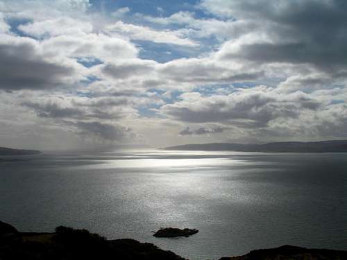
We retraced our steps in pleasant afternoon sun. The hills further inland still had cloud on them but as we drove back through Glenelg, we could see that northwards, towards the Isle of Eigg there were large areas of sunlit sea and passing over the Ratagan pass, we could see the Five sisters of Kintail were free of both cloud and snow.
So, the improvement wasn’t temporary. This turned out to be the best weather day of the week and although we enjoyed our coastal walk, particularly the views of Knoydart, we couldn’t help thinking that with hindsight, we would have done something a bit more adventurous.
Looking over the sea to Skye.
Coire Lair/Easan Dorcha circuit
Hills above the Achnashellach Forest.
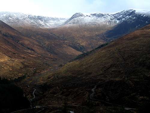
After aborted attempts on Moruisg (Wednesday) and Sgurr nan Airgid (Thursday), both due to poor weather, we returned to Moruisg (928m) on Friday only to find that what was visible of the upper slopes was now covered with a layer of new snow. Furthermore, cloud was blowing through on the strong wind confirming the forecast of “…possible snow showers” during the day.
After a few minutes of contemplation, we decided on the easier option and drove back down Glen Carron to park at Achnashellach station.
We walked up the private road to the station where we met a local woman walking her dog.
We crossed the railway line together and after a chat about where we were headed, she gave us some directions and we were off, heading west on the forestry track.
Up ahead, we got a good view of Fuarr Tholl (907m), looking very wintry in its new snow but backed by some blue skies, the track continued into an enclosed area where most of the trees had been cleared. I was a little worried we had missed a path but suddenly a painted sign appeared on a rock showing us the way, we followed this out of the enclosed forestry area and continued upwards, following the River Lair.
Soon, we were out of the trees and got our first glimpse of Beinn Liath Mhor (925m) and Sgorr Ruadh (960m) and I was suddenly taken with the idea of changing our plans and climbing one (or both) of these Munros!
“I don’t know,” said Marie “look at that cloud coming in”.
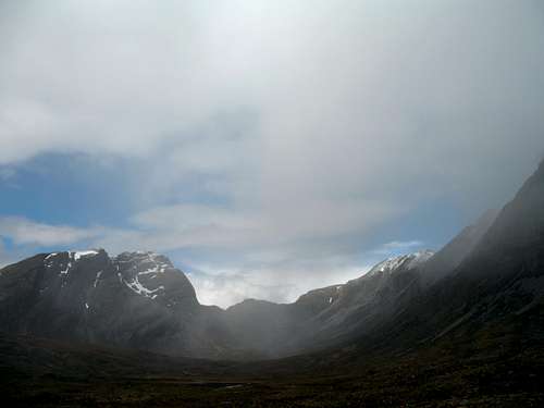
As we spoke, a dark cloud blew over from behind Sgorr Ruadh and filled Coire Lair in front of us, stray snowflakes reached us on the edge of its influence.
Coire Lair.
Sgorr Ruadh (960m)
My conviction wavered and we continued on the open, rocky path until we reached the junction of the path descending from Sgorr Ruadh. As I checked the map, we were passed by another walker.
“What are you up to today”, he asked.
“We’re probably going to go down to the falls at Easan Dorcha and back to Achnashellach” I replied, hedging my bet slightly.
He nodded, “That’s a good walk”.
And then, I added. “We were wondering about going up Beinn Liath Mhor, if the weather holds”.
I expected him to say something like, “yes, what are you waiting for, you wimps!”
Instead, he frowned. “I dunno, weather looks a bit iffy! That’s a good route, I’d save it for a better day.”
Marie looked at me as if to say, “…told you.”
He and his friend were walking up Core Lair, searching for some gear they had lost the previous week. His comments put paid to any thoughts I had of summiting that day. Although, it did clear again for a while, it didn’t last and was probably the right decision.
We continued on the path, heading eastwards and up to the high point of our route at the south east end of Beinn Liath Mhor. We dropped a little in height to get out of the wind and, as the sun was now shining, we stopped for lunch and to admire the views further to the east.
From here we had views across the open ground of heather and rock and in the far distance we could see the snow-covered peaks of the Fannichs.
Coulin forest.
After lunch, we continued on a long, gentle descent which runs parallel to a stream descending towards Easan Dorcha. As we got lower, we noticed the odd, lone Scots Pine appearing, then groups of them and finally Birch trees alongside the river as we returned to the lower altitudes.
Views of parts of Beinn Eighe (around the “Black Karls” area) became visible towards the north. Covered in snow but also in the sun (of course!). Later Slioch (980m) on the far side of Loch Maree, made an appearance just as we arrived at the falls at Easan Dorcha.
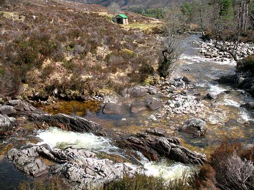
We crossed the wooden bridge to the wooden “Bothy” – no bigger than a large garden shed – and read the attendance book for a few minutes.According to the local tourist information, Robert de Niro and Michelle Pfieffer visited when they were filming “Stardust” in 2006, no sign of anyone today!
Easan Dorcha.
From here, a well-appointed track lead us down to cross over the River Coulin at an old stone bridge. This track took us southwards and up towards the Coulin pass at 286m, regaining most of the height we had lost!
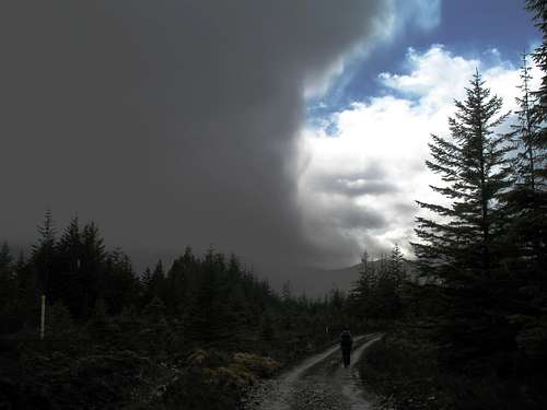
As we had been heading southwards for a while, we realised that the weather was worsening again. We were heading into the wind and up ahead was a wall of dark cloud, growing in size as it approached. It had the look of a huge wall of water, like a japanese drawing of a todal wave.
We had a last view of Beinn Eighe, Slioch and the Fannichs before crossing the pass and descending in to forest and westwards towards the clouds.
“Do you think we’ll get back to the car before the rain starts?” Marie asked.
“Yeah, I think we’ll make it” I replied hopefully.
It turned out I was wrong, 15 minutes later it was raining.
It poured!
Here comes the rain again! Coulin Pass.
Coulin Pass, after the rain.
We descended through, the forest in a cold shower and as it stopped, we sat on the wall of a small bridge to study the view southwards and have a warming cup of tea. Across the glen, we could see the mountains above the Achnashellach Forest as a snow shower swept across them. Further up the glen, Sgurr nan Ceannaichean (915m) and Moruisg were next to feel the force of that shower, the look and feel of winter returning to the mountains.
Continuing, we were treated to a superb view westward down Glen Carron and in the distance, Loch Carron seemed to be in sunshine whilst overhead, dark clouds started to spill rain down on to us again.
We descended as quickly as we could, back to the railway station and down to the car but we got very wet again. Only, in the final 100 metres did the rain stop and the sun came out, to add insult to injury.
A fine circular route with great mountain scenery including some wild, wide open views.
Better luck next time
Next day, we were leaving… the weather was perfect again!
Sallachy, Loch Long.
Blue skies, a pleasant breeze and the first views of some of the higher mountains since we had arrived, white with the new snow cover.
Not the return to Scotland I had hoped for and no summits but it was good to reacquaint myself with some “old haunts”. For Marie, on only her second visit to Scotland, I think she saw more of the attraction of the place than she did on the first visit and hopefully we can return in the future.
Scotland is a land of complex moods, many of them dark but also with many wild open spaces to explore if you don’t make it onto the mountain tops.
Parents refers to a larger category under which an object falls. For example, theAconcagua mountain page has the 'Aconcagua Group' and the 'Seven Summits' asparents and is a parent itself to many routes, photos, and Trip Reports.


Comments
Post a Comment