
|
|
Trip Report |
|---|---|
|
|
57.25528°N / 5.31738°W |
|
|
May 24, 2008 |
|
|
Hiking |
|
|
Summer |
Summary
This week in the highlands was my hardest ever. Despite a rest day I completed the following:- 22 Munros (including a second ascent of Ben Nevis)
- 17 Munro Tops (smaller summits below the Munros)
- Over 44,000 ft of ascent (four and a half times the three peaks)
- Approx 140 miles of hiking
If that wasn't enough I set a personal record in the month of may for a total of 80,000 ft of ascent. That is the equivalent of either eight times the three peaks - or the equivalent of climbing Snowndon every day of the month!
24 May - Ben Vorlich
I left home at 05:55 in the morning for the long drive north to Scotland. Three and a half hours later I arrived at Inveruglas on the banks of Loch Lomond, to climb Ben Vorlich in the Arrochar Alps.After a short climb on a track it was time to climb the slopes, which involved sixty minutes of steep trackless ascent. On the ridge it was windy but increasingly sunny. On approaching the summit I identified a path on the west face - which isn't on any of the maps or my books. Whilst annoyed to have missed it, I was overjoyed to know I had an easier way down!
Having made it to the summit for some views I proceeded to descend with a guy I met up there. Chatting all the way, it hardly took any time at all.
After a long drive north, I arrived in Portree around 18:30.
25 May - The Round of Coire Lagan
I woke to blue skies - and thanked my lucky stars that I was goingto get a good day for this. I met my guide, Paul Tattersal, at Sligachan and we drove round to the Glen Brittle Memorial Hut for the start of our hike.The hike up Sgurr Dearg was rocky and tough in places, but overall pretty quick and we were soon on the summit where I got my first up close view of the Inacessible Pinnacle, the main objective of the walk.
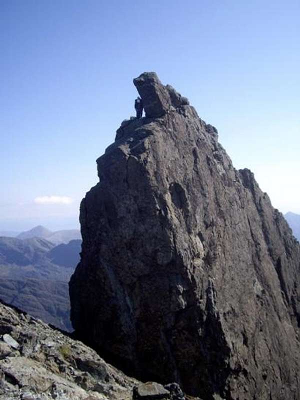 First Sight of the Inaccessible Pinnacle
I would admit to being slightly nervous at this stage, but I had to go on! We descended to the col at the bottom of the east ridge of the pinnacle. I got harnesses up and we waited in line for our turn. In the picture below you can see the line of ascent marked by the red rope hanging down.
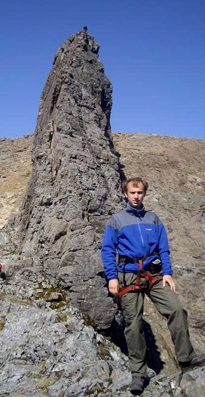 In front of the Inaccessible Pinnacle
My guide headed up first to tie on the rope halfway and I began to climb. Overall the climbing was no harder than I had done before on the Aonach Eagach - just steeper and more exposed. However there was now a stiff breeze, which made you think twice about each move. I had given my camera to Paul so he was able to get some shots on the way up, including the one below.
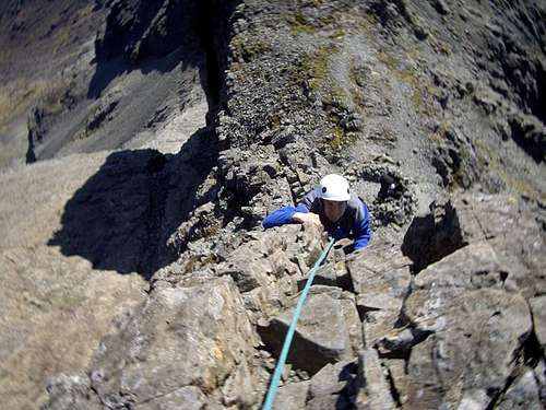 On the Inaccessible Pinnacle
At the top we rested and waited for the others up their to abseil off. I took the oppurtunity to climb up and sit on the summit block, a fairly uncomfortable position. When it came to my turn for the abseil however I discovered a problem - I was utterly unable to trust the rope! After a few tries to put my weight on the rope I eventually ended up downclimbing the vertical east ridge - using the rope as an aide.
I had done it! I could continue on with my round of the Munros knowing the hardest one was done.
We dropped down to continue along the ridge, heading out on the airy exposed ridge to Sgurr Mich Choinnich. After a lunch break near the summit, we headed back to cross Collies Ledge so we would be able to get round to Sgurr Alasdair. This ledge is more a series of ledges that allow you to inch your way round the bottom of Sgurr Mich Choinnich. It generally looks better than it is!
 On Collies Ledge
We then crossed over Sgurr Thearlaich to reach the top of the Great Stone Shoot. You could hear rocks falling below as people forced their way up the scree. Paul and I passed a couple heading for the summit of Sgurr Alasdair, but they turned back before reaching the crest of the ridge.
After surmounting Sgurr Alasdair, we descended over Sgurr Sgumain to descend the Sgumain Stone Shoot - a much better alternative to the Great Stone Shoot. Fewer people, less loose rock. Once that descent was over, all that remained was a quick sunbath on the rocks in Coire Lagan before heading back to the car.
26 May - The Grey Corries
Another sunny day presented itself on the Monday. I drove round past Spean Bridge to the farm at the bottom. The farmer said it was fine to drive up the road, so I took the mile and a half body jarring drive up the gravel road - saving myself an hour of hiking.I decided to do the ridge west to east, to give me the oppurtunity to decide whether to include the outlier Stob Ban at the end of the day. It was sunny, so after the initial ascent I was able to lay out and sunbathe.
The ridge itself was great. From the first main summit at Stob Coire Easain it was rocky and sharp, all the way to Stob Choire Claurigh. I met the first person of the day on the ridge and another couple later on. I headed down to include Stob Ban in the round, meeting quite a few people on the descent.
I rested for a period by a lochan at the col, before starting the hard climb up to Stob Ban. The route was covered in loose scree so it felt much harder than it should have been. There were quite a few people on the summit, but they didn't seem to want to chat so I headed down for the nine kilometre walk out.
 The Grey Corries
At the end of the day I had a barbecue! I managed to eat half a chicken breast, three quarter pounders and a baked potato before collapsing asleep...
27 May - The Lochaber 4000 Footers
My parents were staying up in Fort William that week and my Dad wanted to go up Ben Nevis. He knew it would be hard for him, but wanted to give it a try. On that basis I reluctantly agreed to go up the tourist path again - having done it once before I wasn't keen to return.It was another warm day, but with a fair wind my Dad and I made excellent progress - reaching the top of the zig zags in three hours. There we encountered the first major snow, requiring a tiring crossing of a snowbank. Unfortunately I wouldn't come back this way - or it would have been great fun sliding back down!
 Snowbank on Ben Nevis
After a final push we arrived on the summit in under three and a half hours - a lot faster than I expected to! The summit was under a foot of snow and the top of Gardyloo Gully looked treacherous. Despite this, people were still heading out onto the snow to get pictures. I warned some of the dangers but they didn't think it was a serious problem - no wonder people are killed on Nevis every year.
 Cornices on Ben Nevis
My Dad headed down the tourist path but I continued south east towards the Carn Mor Dearg Arete - the fun way!. This involved sustained scrambling on the ridge, made even more fun my a persistent cross wind that might knock me off at any moment. There were quite a few people heading in the other direction, as traditionally the route is used to approach Nevis and not return from it. Reaching the other end at Carn Mor Dearg I received an excellent view of both the Arete and the North Face of Ben Nevis.
 The Carn Mor Dearg Arete
 The North Face of Ben Nevis
I chatted to a few guys on the top of Carn Mor Dearg until they left. After a good rest I made my decision. This wasn't enough, I had to go for it - the Aonachs were too close! The descent was rocky but fairly easy. The ascent up onto the summit ridge of the Aonachs was a lot harder! It took forty minutes of hard work to get up there. However at this point I got my well welcomed second wind! I positively dashed up to the summit of Aonach Beag. Here I found a prime example of why you don't go near the cornices unless you know exactly what you are doing - as this one was breaking off, and it was clear there was nothing under there...
 A collapsing cornice on the edge of Aonach Beag.
After completing Aonach Beag I headed back along the ridge to Aonach Mor. I had received a text to say my Dad had moved my car to the Nevis Range Car Park, so it was just a simple matter of descending the four thousand feet to the car park. I did this via the gondola station and mountain bike tack. It took about ninety minutes in the end.
I finished the day absolutely shattered. I had done nearly twenty miles and over 7,500 ft of ascent. That would be my second biggest day ever!
28 May - Rest Day
It was going to rain on the Wednesday so I took a well earned rest day - completely unlike me! I just climbed a couple of small hills and took a walk up the Caledonian Canal - ten miles ish in total. An easy day...29 May - The Strathfarrar six
It was going to be a good day, so I headed up early to Glen Strathfarrar. I arrived at 08:40 along with a few others and we waited for the Glen to open. For those who don't know - the gate opens at 09:00 and they only let 25 cars in a day. Fortunately it was a Thursday or I would probably have joined the end of a large queue. Three of us agreed to coordinate our walk - which meant we all avoided four miles of road walking at the end of the day.The day was misty earlier on but became a lot clearer later on with bright sunshine. Starting with fleece, jacket, hat and gloves - finishing with just a base layer and a sun hat.
30 May - The Fannaichs
The following day I headed north towards Ullapool and tackled the eatern four of the Fannaichs. This meant tackling the heathery slopes under the hot sun. It was hard work, but eight and a half hours later I was done - four more Munros completed.31 May - An Teallach
When I woke up on the Saturday Ullapool was covered in cloud and mist. I resigned myself to a day tramping around the remaining Fannaichs and headed off south to Braemore Junction. As I approached I saw blue sky over the Letterewe Wilderness and realised the cloud was only over the see. I quickly texted my parents and confirmed a change in plans - it was time to climb An Teallach!The initial climb was via a track and a boulder slope but was over in acouple of hours. It was then time to tackle the hardest section - the Corrag Buidhe pinnacles. I met up with a couple (Lucy and Alex) and another gentleman (Jim.) There was an option to use a path below the summits, but Jim agreed to go up on the ridge with us.
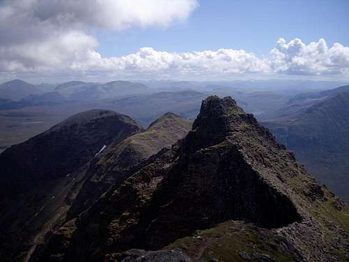
The buttress above us was difficult to climb, and probably reached Grade 3 scrambling in places - similar to what I found on the Inaccessible Pinnacle a week before. The ridge narrowed terribly at the top, providing only two feet of width to walk on, with a massive drop on one side - and not an insignificant one on the other. On reaching the last pinnacle I turned for a photo. Below you can see the contour path on the right, for the more casual walker. I had of course walked along the line of pinnacles on the left!
 Corrag Buidhe
A short distance further on brought us to the final pinnacle, known as Lord Berkeley's Seat. This was an airy climb up, and on the summit we took it in turns to stand on an area a foot square with sheer drops on three sides! Lucy and I both reascended so that pictures could be taken of us...
 Lord Berkeley's Seat
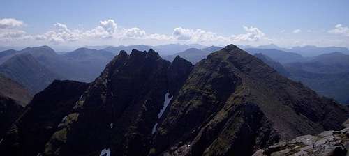
After this all that was left was a short scramble up to the first Munro - Sgurr Fiona. From here we looked back to the pinnacles.
 An Teallach Pinnacles
After taking a panorama I traversed to Bidein a'Ghlas Thuill the second Munro of the day. From there you could get the view of the entire summit ridge.
 An Teallach Summit Ridge
Jim headed off for the easy hike down the main path. Lucy, Alex and I opted to hop along the harder east ridge to bring us directly back to the car. It was tough rock hopping on a 45 degree slope but got us down, only to find a mass of ankle snapping heather. It was a miracles we all got down to the path without injury. I headed on ahead and got back to my car. Later in the evening I compared notes with Jim in Ullapool, to find he had made it back half an hour before me - despite having to walk another five miles more! Goes to show how hard work our route down was...
01 June - Am Faochagach
On the final day of my holiday I got up before six, knowing I had a long day ahead. Am Faochagach beckoned. It is known to have a horrendous river crossing, so I reasoned that the ascent would be best done then - following virtually no rain over the previous two months. I was right, there was minimal water and I just used the stepping stones to get across.When I got higher up there was a partial cloud inversion which allowed views to Beinn Dearg. More than I had when I climbed it in torrential rain two days earlier. I was quickly back down, and prepared myself for the 350 mile drive home...
 Beinn Dearg

Comments
Post a Comment