The opening lines of Charles Dickens novel, “A Tale of Two Cities”, set in London and Paris at the start of the French revolution, are amongst the most famous lines in literature, so why do I mention them here and what is their connection to our trip to the Scottish mountains?
I suppose the connection is quite tenuous, there is little comparison in the content of the novel to our holiday experience but the words themselves seemed very apt at the time.
Perhaps it was the contrast in our feelings of having a great time on holiday amidst a troubling period in our lives. Also, these words seemed to form a recurring theme over those weeks.
The fact that the first section of the novel is subtitled “Recalled to life” also seemed to be significant.
Introduction - The worst of times
The UK government’s prediction concerning the Covid pandemic at the end of 2020, which suggested that life “would be back to normal by next Easter”, was now a distant memory. We had hoped to be able to travel to Europe easily by 2021 but Easter was extended to June and then July and then later. Each time, the small concessions made on travel restrictions were so small that it seemed even more difficult to leave the country. By August, I was trying to convince Marie to give up hoping. Of our usual favourites, it was illegal for us to try to go to Austria and travel to Italy required tests and a period of quarantine once arrived, other countries had similar restrictions. Re-entering the UK required more tests and possibly expensive isolation quarantine. All in all, not very practical or enjoyable for a holiday trip.
Surely, the worst of times?
“Why don’t we go to Scotland?” I suggested to Marie. “If we don’t do something soon, the summer will be over and it will be too late.”
I was well aware that Marie had mixed feelings about going to Scotland. It is a long drive and on our two previous trips the weather had been pretty poor. Gradually, I managed to convince her to take the risk with the weather and as we had left it so late to book accommodation, we had to split the two weeks between two different places.
As we sat in a motorway traffic jam in the hot sun, heading northwards, I remembered Dickens famous lines. Would this trip be the worst or the best of times?
Northern Cairngorms - The best of times
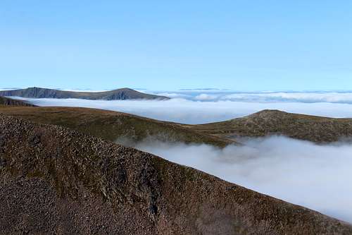
Misty morning, Cairngorms
After two days of travelling, we arrived in Aviemore the main town of the area in the early afternoon and under clear blue skies and warm sun, I had never seen it like this before! On most of my previous trips to the area, I had experienced thick, grey cloud which covered the mountains and produced rain or snow. The only clear days had been in winter and had been terribly cold.
Now, we parked the car and sat on the shore of Loch Morlich eating our sandwiches and admiring the views of the northern corries. Marie looked at the weather forecast on her phone.
“I think today has the best weather of the week.” She said. “Although, Thursday might be ok too.”
We had rented a beautiful cottage near Tomatin, about 15 miles north of Aviemore and loved it the first time we walked through the door. All we needed was some reasonable weather.
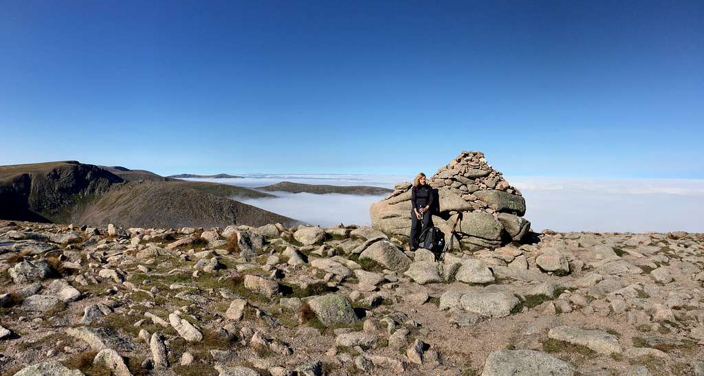
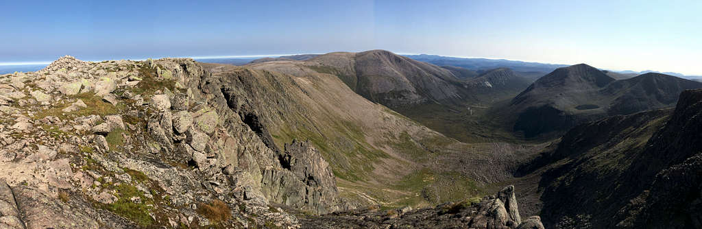
Ben Macdui (1309m) and Cairn Gorm (1244m)
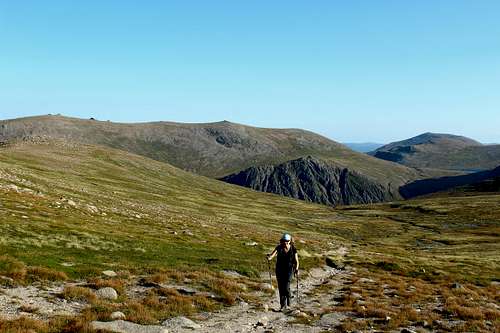
After having a day recovering from the travelling during which we had a short walk in the afternoon, we prepared to do something worthwhile on the Monday. Once again, we awoke to grey skies although the forecast predicted that it might clear for a while on the higher mountains.
We drove to the ski development car park at Coire Cas and were ready to set off before 10.00 am. The sky was overcast still and the cliffs of the northern corries rose up into the clouds as they drifted across the invisible plateau above.
We headed southwest on a very good path which took us across the moors at the foot of Coire an t-Sneachda (Corrie of the snow) towards the north – south ridge of Miadan Creag an Leth-choin. The network of footpaths has been greatly improved since my last visit, probably in a bid to reduce the hillside erosion problems.
Soon we were walking in the mist. This was how I remembered the Cairngorms, little in the way of visibility and slightly damp. At least it wasn’t cold or actually raining. We made good time as we gained height, had a glimpse of the loch beneath us in Coire an Lochan and soon the angle of ascent had eased and we knew we were on the plateau itself.
I took a compass bearing just in case but there was no need, the path was pretty clear and visibility wasn’t as bad as I had suspected it would be. That said, I was disappointed we couldn’t see west, over the cliffs and into the Lairig Ghru.
The path ascended gradually, then dropped a little more steeply to pass near to Lochan Buidhe which we could see to our left. This area was the scene of a mountaineering tragedy in 1971 when a group of teenagers and their guide became stranded in a blizzard. Six died and only the group leader and a boy survived.
Nothing for us to worry about on this day though. In fact, I remarked to Marie that although we had only seen a handful of people, that was a lot more than I had ever seen before. Furthermore, although most of them were well equipped we passed a family of four who seemed a bit out of place. The father and young son were dressed for the mountains whilst the mother and daughter were very casually dressed in light shoes and seemed to have no waterproofs or other protection. We passed them and the path vanished into a typical Cairngorms “sea of boulders”, we didn’t see them again.
Luckily, the way was marked with cairns so we only had to find the next cairn in the mist and follow it upwards. We continued until two things happened almost simultaneously.
Ben Macdui (1309m)
First, I noticed on my left and just a little higher, what appeared to be a hilltop.
“I think that’s the lower top at 1295m.” I called to Marie after consulting the map.
Then, I realised that it suddenly seemed a bit brighter and that we had some blue sky directly above us. It was clearing a bit.
“We’re nearly there”.
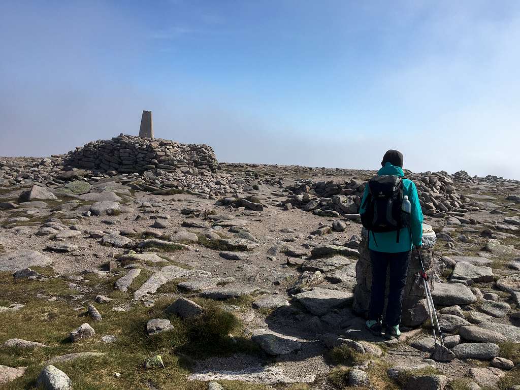
We followed the way upwards to the south and soon saw the trig point on the rocky summit, a few minutes later we were there at 12.40 pm. As we stood on the top, the clouds cleared for a moment to the south and we had glimpses of the wilderness beyond.
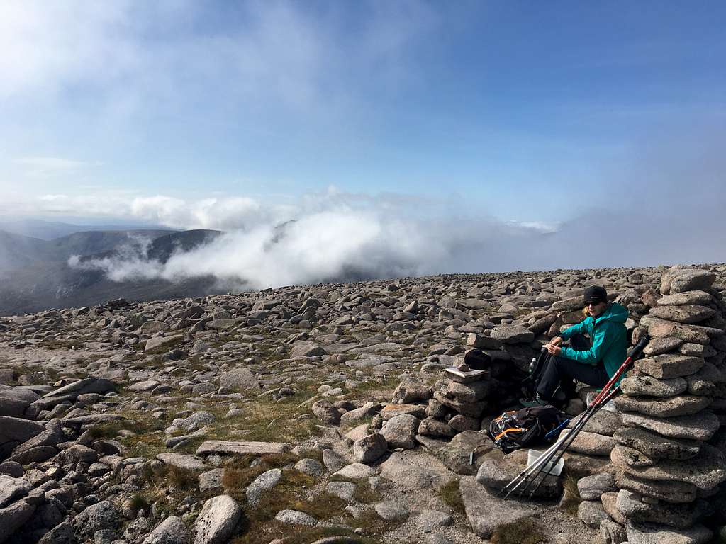
We wandered to the south to get some better views but the clouds were playing with us. One minute it was clear, then the clouds rolled in again. We found a dry-stone enclosure to keep out of the breeze and sat there to have lunch.
“Do you see that ridge with the path on top?” I asked Marie. “That’s Carn a’ Mhaim I think. The river is the Dee that flows from the Lairig Ghru.”
“Wow, it looks like it goes on forever.” Marie replied.
It certainly went a long way.
We finished our lunch and headed back the way we had come towards Lochan Buidhe.
Ben Macdui (1309m)
As soon as we left the summit, the cloud rolled in again and we were back in the murk. At the Lochan we headed east this time on a path on the southern slopes of Cairn Lochan. It was misty and cool but not too cold and we encountered more people than ever.
We followed the path over the summit of Stob Coire an t-Sneachda and onwards to the western slopes of Cairn Gorm. This seemed steeper than I remembered but it may have been because of the mist. Soon we reached the weather station on the top and stopped for a tea break. I was disappointed that we couldn’t see anywhere south as I had never seen that view on my two previous ascents but it was enough to be there.
“We’ve ticked off Ben Macdui and Cairn Gorm and if we can do Braerich as well this week, it will be a success.” I exclaimed.
“It was a good day.” Marie agreed.
We took in the summit cairn (which looked to be lower than the weather station) just in case and headed down the paved footpath to the closed Ptarmigan restaurant. We emerged from the clouds into a grey, overcast day and found our way through the ski paraphernalia and down the ridge of Sron an Aonaich back to the car park for 5.00 pm.
A very satisfying day.
Beinn Mheadhoin (1182m)
Carn Etchachan (1120m) and the Shelter Stone crag.
We had a rest day as the forecast promised a strong wind and drizzle plus we needed to shop for some food. In the end, there was no drizzle, some wind and we got the food. The forecast for the following day (Wednesday) was cloud which might clear in the afternoon. We weren’t that confident it would be good so planned to try to climb an easy Munro above the town of Newtonmore to the south of the Cairngorms.
However, at about 9.00 pm on Tuesday we checked the forecast again and it had changed…it was much better!
The forecast predicted full sun on the Cairngorms in the afternoon.
“It won’t be that hot”. I confidently predicted. “Probably like it was on Ben Macdui the other day.”
“That’s better than we normally get.” Marie replied.
Consequently, we decided to head for Beinn Mheadhoin, south of Cairn Gorm itself and deep into the Cairngorms wilderness. I knew little about it as I hadn’t expected the weather to be good enough to warrant an attempt on such a remote mountain, so I hadn’t worked out the route.
“It’s a very long route with lots of ascent and descent.” I warned Marie.
An hour later, we had worked it out… so long as the weather forecast was correct!
We left the Coire Cas car park at 9.40 am. It had been grey and overcast since we had woken up and once again the Northern corries were covered with cloud. What’s more, it didn’t look like it would change soon!
We headed uphill between the ski paraphernalia on another excellent path. Apparently, we were being diverted as repair work was being done. We saw a number of workmen working but the path was always good.
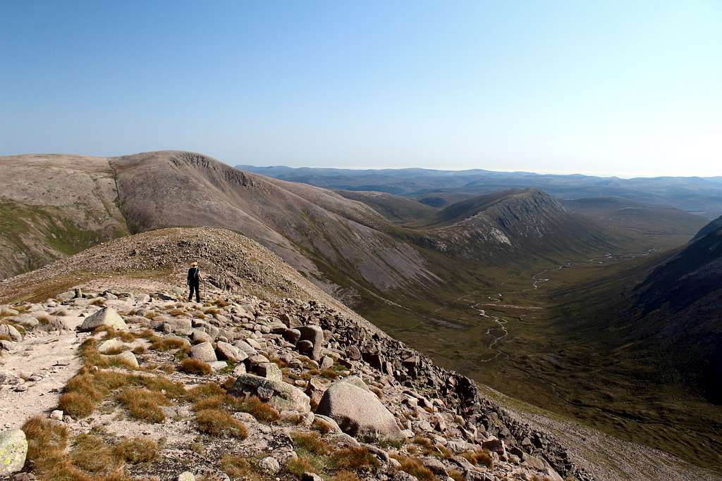
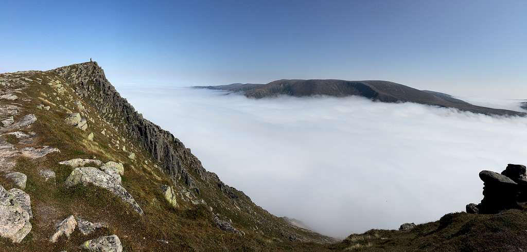
Gradually we left the ski area behind and ascended further up the Fiacaill a’Choire Chais in thick mist. The path grew steeper and once again I saw blue skies above us. We emerged from the mist suddenly into a sunlit world of mountain ridges and a sea of cloud lapping at their lower reaches. The lack of visibility had hidden the fact that we had climbed up to a height of around 1100m and now we could see for miles.
The top of Fiacaill a' Choire Chais, Cairngorms.
We reached the large cairn shown on the map as being at 1141m and stopped for a breather at 10.25am. It was glorious in the sunshine; the entire plateau already was bathed in warmth and there was not a cloud in the sky.
Looking southwards, we could see our grassy route descending into Coire Raibiert and further on, a mist filled Glen Avon. Behind and above the mist was the summit plateau of Beinn Mheadhoin with its rocky tors silhouetted against the bright skyline.
“That’s it ahead? Marie asked, pointing at the scene.
“Yes, I think so.” I replied. “This is the first time I’ve ever seen this view; it’s always been covered in cloud before.”
We descended on a path, parallel to the gentle stream, the Allt Coire Raibeirt. Marie was hurrying along whilst I kept stopping to take pictures. Somewhere around here I realised that not only had I not packed my sun hat but we had left the sun protection cream in the car (it was Scotland, after all!). I put a neck protector over my head to use as a substitute.
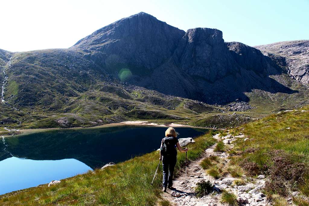
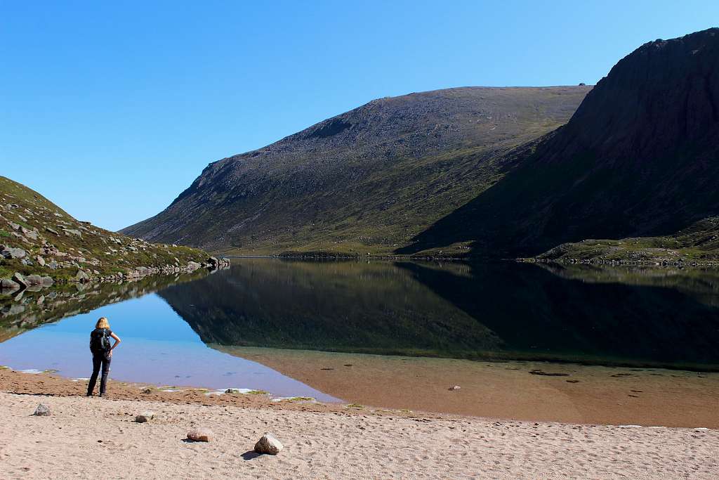
The gentle descent steepened as the path descended into a rough gully and the stream became a series of waterfalls as the path and river sometimes merged into one. Ahead, the mist had been burnt off by the sun and we could see Loch Avon below – another new sighting for me
Part way down, we were caught up by a young woman virtually running along, we stood to one side and had a chat. She was doing the same route as us.
Soon, she was off again and we descended carefully, making sure not to slip on the smooth rock.
Near the loch side, we crossed the river and headed west on a small path above the beautiful loch. Straight away, we saw the pointed mountain, Carn Etchachan (1120m) and the square topped Shelter Stone crag before us. Named after the large rock at the foot of the crag that has often been used as a shelter (a Howff) by climbers for generations, I had heard of it but never realised it had such a distinctive shape.
We headed for a sandy beach at the west end of the loch and stopped for a break in the sunshine at about midday. The view was almost impossibly idyllic and the only downsides were the midges that suddenly appeared when we stopped and the fact that we had lost about 400m of height.
“This is so beautiful and peaceful.” Marie said staring across the loch.
“I have never seen these mountains like this.” I said by way of a reply.
Loch Avon, Cairngorms
After a few minutes, we set off again and headed further west towards the Shelter stone on a path that crossed the river feeding Loch Avon – Feith Buidhe – on steppingstones.
Then, we had to begin our climb again, following a path on the southern side of the loch in between Beinn Mheadhoin and Carn Etchachan
By now, it was hot and the prospect of the route ahead made it seem more arduous than I had imagined it would but gradually we made height again. For a while, the path was steep and then, it suddenly lessened and we quickened our pace as Loch Etchachan appeared on our right.
At the southeastern end of Loch Etchachan is Little Loch Etchachan and here we turned left and up steeply again on a path on the west slopes of Beinn Mheadhoin. The hillside was covered with rock and gravel and interspersed with rough grass. Gradually, we made more height and crested a ridge to emerge on a plateau. In the distance, we saw a pointed, rocky top.
“There it is!” Marie exclaimed, pointing to the tor ahead.
“That’s not the summit, I’m afraid.” I had to reply. “The highest tor is further back behind this one.”
Up to this point, we had only seen one other person, the woman who overtook us earlier. Now we could see another group ahead of us, or rather we could hear them! Even though they were a long way away and only three of them, we could still hear their voices shouting and whooping!
We reached the first, pointed tor and surveyed the scene, the views were fabulous. We could see northwards – from whence we had come – Cairngorm, rising above Loch Avon and Stob Coire an t – Sneachda, Ben Macdui was to the west then, Derry Cairngorm and to the south, a vast series of rolling hillsides as far as we could see.
“I had no idea the Cairngorms were so big and wild.” Marie said.
“Yes, it’s surprised me too.” I replied. “I knew it was big but I’ve just never really seen it.”
We continued across the barren plateau towards the summit tor. Under the clear blue skies and hot sunshine, it reminded me more of Morocco than Scotland.
Beinn Mheadhoin (1182m)
We stopped for lunch around 2.00 pm and sat on a rock whilst the trio in front of us scrambled up the summit tor and pranced around, shouting on the top.
I thought they would tire of these antics and leave but after about 20 minutes they were still shouting and posing for photos. I scrambled up the tor and tried to ignore them as they posed for endless selfies. The scene seemed so ridiculous and out of place on this remote mountain.
We left them to it at around 2.40 pm and soon we were on our own with only the sound of the wind blowing across the vast plateau. I confidently predicted we would be back at the car by 6.40 pm but Marie was sceptical!
We made good time back across Beinn Mheadhoin’s summit plateau and descended towards Loch Etchachan with fantastic views again. Then it was back down towards Loch Avon, looking even better now in the afternoon sun.
Loch Avon, Cairngorms
We descended beneath the Shelter stone crag and crossed the steppingstones on our way back to the loch side.
Suddenly, I heard a loud, high-pitched buzzing and saw something flying just above me. For a moment, I thought it was a giant midge or maybe a Dragonfly but then I realised it was a drone.
It buzzed around and followed us as we continued to the Loch Avon shore line and missed the path we had used in the morning. We followed the alternative track alongside the Loch and tried to ignore the drone, still hovering nearby – its owner stood on a mound at the loch end, apparently unaware how annoying this sort of intrusion is.
Beinn Mheadhoin (1182m)
We reached the Allt Coire Raibeirt and sat on a rock around 4.30 pm. We both felt tired and neither of us were looking forward to re- ascending the 400m up towards the cairn at 1141m.
“…and we still have to go down the other side!” Marie reminded me in case I had forgotten.
We drunk as much of our supply of water as we dared and had a sweet and set off. Straight away, I found some extra energy and set off at a good pace, leaving Marie behind.
“You’re going well suddenly.” She said as she caught me up.
“Yes, I’m feeling ok.” I said, surprising myself.
We climbed upwards in the late afternoon sun seeing very few people, despite the fine conditions.
We reached the large cairn again at about 6.00pm and drunk the last of our water, then headed down into Coire Cas.
We reached the car at about 6.50 pm. 9 hours and 10 minutes after setting out and found our emergency can of Coca Cola in the boot! Marie rubbed her feet while I took yet more photos.
I had a slightly sunburned face and neck but we had experienced one of my best ever days in Scotland and climbed a remote mountain that I had never even been able to see before.
Marvelous.
Braeriach (1296m)
Braeriach (1296m)
Arriving at the “Sugar bowl” car park below Coire Cas the next day, if anything, it looked even more overcast than the previous day. We left at 9.25 am and apart from a couple of runners, we saw no one. We descended to the footbridge over the river and headed upwards in thick, damp mist. We followed the path as it wound its way across the hillside and gradually upwards. After nearly 50 minutes, we noticed a couple descending towards us. They were both wearing full head coverings, like a couple of Bee keepers!
“That’s a good idea.” I said as they passed.
“Yes,” the woman replied. “I can’t see where I’m going but it keeps the midges off!”
We continued along the path and when they were out of earshot, I turned to Marie.
“That’s a bit over the top don’t you think? We’ve hardly seen any midges.”
Two minutes later, grey rocks appeared out of the mist and we reached the Chalamain Gap. I knew I had been there before but I hadn’t remembered it to be that big. It was a valley full of boulders with no discernable path through.
A man appeared from behind us and suggested we stick to the lowest part of the valley to scramble through. We followed his advice and were immediately swamped by hordes of midges!
“I wish we had some of those head coverings.” Marie said.
We scrambled over the loose damp boulders as quickly as possible and as we reached the top of the gap, we emerged from the mist and into sunlight.
Suddenly, we had good views of the Lairig Ghru, the northern corries of Braeriach and Sgor Gaoith across Gleann Eanaich, all in warm sunshine.
Although, this was supposed to be the shortest route to the summit of Braeriach, the downside of this route was that we now had to lose around 100m of previously gained height in order to cross the Lairig Ghru, a huge pass cutting through the Cairngorm mountain range from north to south.
The path descended quickly to the steppingstones on the Allt Druidh and straight away we started to ascend the long ridge of Sron na Lairige. This path has been well constructed which helped us as it seemed particularly steep in the heat we were experiencing.
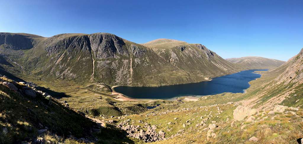
Lairig Ghru, Cairngorms
Gradually, we made height until the angle of ascent eased as we reached a large boulder field. The path seemed to vanish and reappear as we found a way through the rough ground. Marie stayed on a direct route while I wandered over towards the cliffs above the Lairig Ghru, around 300m below. Across the huge defile, I could see Creag an Leth – choin (Lurchers crag) (1053m).
“Have you climbed Lurchers crag?” Marie asked.
“Yes,” I replied. “When I was here in 1983.”
My first trip to the Cairngorms was in 1983 when I attended a course at nearby Glenmore Lodge, the national outdoor training centre. We climbed Lurchers crag on one day and our guide told us a story.
It seems he had been employed by some clients to take them up a mountain “named after a dog.” Consequently, he took them up Lurchers crag but he was curious as to why they wanted to go up such a mountain?
“We are in contact with beings from a planet orbiting Sirius, the dog star.” They told him. “When the world is about to end, they will arrive on Earth to collect their followers from the mountain named after a dog. We calculated this must be the one and we wanted to know how to climb it in advance!”
“So,” he told us. “I’m not promising it will happen…. But if it does, you know where to come!”
The boulder field ended and we followed the path across a grassy hillside with always improving views of Ben Macdui, Carn a Mhaim and the wilderness where the Lairig Ghru turns into Glen Dee. Once again, we were stunned by the sheer size of the wilderness before us.
Braeriach (1296m)
The path continued over the top of Sron na Lairig and then lost height before rising again to another top. Finally, we could see the summit ahead.
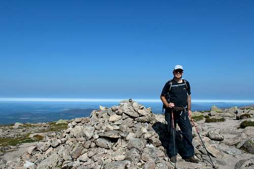
We arrived at the summit at 1.35 pm, just over 4 hours after starting out.
Braeriach was my 100th Munro so I was pleased to get there and Marie took a photo of me next to the summit cairn.
(It had taken me 17 years to do my first 90, then another 21 years to do the next 10!)
We sat in the sunshine, ate our lunch and admired the views southwards. The cliffs below the summit are spectacular and there are great views of Sgoran Lochain Uaine (The Angel’s peak), Cairn Toul as well as the aforementioned Ben Macdui and Carn a Mhaim.
We were preparing to leave when a young couple arrived and caught our attention.
“How are we going to do this?” The young man asked.
The young woman responded (to our surprise) by taking off her shirt – she had a bra on!
Then, she tried clambering up onto the summit cairn. Now, this is just a pile of loose rocks and they shifted and slipped as she stepped up and tried to strike a dramatic pose whilst her companion took photos of her. I expected her to fall any second but she managed to keep her balance while we watched.
“You never told me I was supposed to climb all over it!” Marie remarked.
“Come on let’s go.” I replied.
We left at around 2.20 pm and returned the way we had come, it took us 4 hours to get back to the car. The views were still fantastic and we had a cooling breeze from the north to help us.
It had been another great day but I felt a little sad.
The mountains of Scotland have always seemed wild and beautiful to me. They can be friendly or, especially in bad weather, they can be quite savage but I have always had a respect for them. There have always been other mountaineers around but for the most part, we had given each other space to enjoy the wilderness on our own.
Some of the people on the mountains over these two days had not been at all like that. They didn’t show much respect towards the mountains and they seem to want to bring the crassness of modern lives into them. Flying drones that intrude on anyone around them. Shouting and prancing about as though they are at a party and ridiculous posing for endless photographs.
Now, I know take a lot of photos too – just look at what I have on SP – but I try not to let my actions interfere with other people.
With the recent travel restrictions, more people are heading to the British mountains and mountain rescue teams have reported a big rise in callouts, mainly due to poorly equipped walkers. Maybe there also needs to be a drive towards better mountaineering education? I don’t think the mountains should be treated as a theme park.
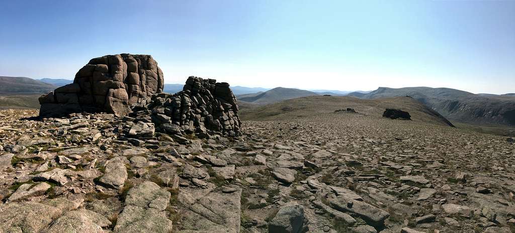
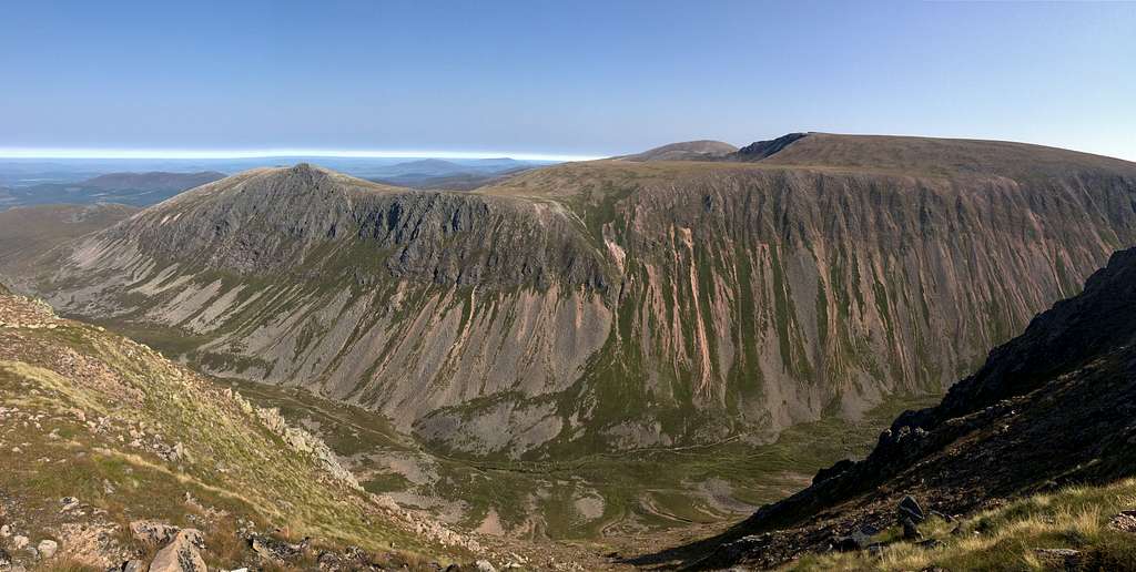
Cairngorms Panorama
Sgor Gaoith (1118m)
Yet another grey start to the day. This time, we had driven down lonely Glen Feshie to the car park near Achlean. Again, it was misty as we left the car at 9.45 am and we hoped it would improve as the day progressed.
We followed a path through a damp, misty pine forest, its floor covered in an array of funghi, some grey and some bright red, to emerge on an open, very misty hillside.
There was little navigation needed as we followed the same path upwards for about 2 hours until up ahead the angle of ascent eased and a large cairn came into view.
At the same time, the mist cleared and we found ourselves above a sea of clouds with the peaks of the Cairngorms ahead of us like islands in the misty waters.
Once in the sunshine again, it warmed up quickly and we stopped for lunch on some rocks in the grassy hillside.
A few people passed as we sat there and a couple waved to us on their way to the summit.
We continued along the broad ridge and over the top of Carn Ban Mor (1052m) then, descended a little before climbing again towards the rocky summit ahead of us.
This was the first Munro I had climbed back in 1983 and it remained in my memory as being a summit in a spectacular position. As we climbed upwards, I was pleased that I felt a similar level of exhilaration seeing the rocky summit looking out over the clouds.
Cairngorm, Braeriach and Cairn Toul were visible to the east whilst I wished I was more familiar with the ridges we could see westwards.
We retraced our steps and descended along the sunny ridge to the large cairn before turning down towards Achlean and plunging back into the grey, murky cloud. For once, the mists had not been burned off and the valleys had remained under cloud all day.
Approaching the summit of Sgor Gaoith (1118m)
Intermission
At the end of the first week, we left our lovely cottage and drove south and east to another one, this time further from the mountains and about an hour’s drive from Braemar.
We spent a day in Glenshee near the big ski development. We had expected it to be reasonably clear but we spent the day in thick cloud navigating around the rocky tops of Creag Leacach (987m) and Glas Maol (1068m). My map and compass work slowed us down and the route took longer than expected. I couldn’t help but think that somewhere else nearby, it would be clear skies and sunshine.
The following day we drove to the car park at Linn of Dee and headed north into the Cairngorms. The route runs along a dusty track to the, now derelict, Derry Lodge. It took us an hour to walk this and we were constantly overtaken by Land rovers and cyclists. Not for the last time, we wondered if we should have hired bikes ourselves.
Contrary to expectations, it was cloudy and we had a little rain as we headed north from Derry lodge up Glen Derry and onto the open hillsides to Beinn Bhreac (931m), a rather non-descript munro.
We sheltered from the cool breeze behind some rocks and decided to save ourselves for the next day and retraced our steps along the dusty track back to the car park.
I had only visited this area once in 1999 and hadn’t seen much of it so far, it didn’t seem as dramatic as the northern part of the range.
Derry Cairngorm (1155m)
Heading towards the summit of Derry Cairngorm
We completed the dusty walk to Derry lodge as quickly as possible in the still, humid morning air and this time, we crossed the bridge over the Derry burn.
Ahead, we chose the middle option of three paths before us and headed up towards Creag Bad an t – Seabhaig. We soon rose above the Scots pines and on to the hot, rocky hillside being the south ridge of Derry Cairngorm.
As we headed towards the top of Carn Crom (890m) – a top along the ridge – a pleasant breeze sprang up and cooled us.
We enjoyed fine views eastwards to Beinn Bhreac – our route from the previous day – the blank expanse of Moine Bhealaidh (Yellow Moss).and distant Beinn Chaorainn and the tors of Beinn a Bhuird beyond. To the west we could see Cairn Toul, Carn a Mhain and the striking top of Sron Riach with the Lochain Uaine at its feet and the summit of Ben Macdui behind.
We headed along the feint path towards the huge, conical pile of rocks ahead of us.
“Is that the top, do you think? I wondered.
“It can’t be,” Marie replied. “We couldn’t have done it so quickly.”
I checked the map, she was correct, this was just the top shown as 1040m on the map and formerly known as “Little Cairngorm.
We passed this on its right-hand side (east) and saw another rocky top ahead. Again, we found a way up the rough, rocky ground to see a summit ahead of us.
Marie reached this cairn, there was another behind it!
“Does that one look higher?’ She asked.
I had to admit it did and we continued to the second cairn, then looked back.
“Now, that one looks higher.” I said looking back.
“No matter, we’ve climbed them both.” Marie said. “Let’s have lunch.”
We sat in the warm sunshine and surveyed the scene. As well as the previous views, we could now see Beinn Mheadhoin and Cairngorm and seemingly endless rounded hills to the north.
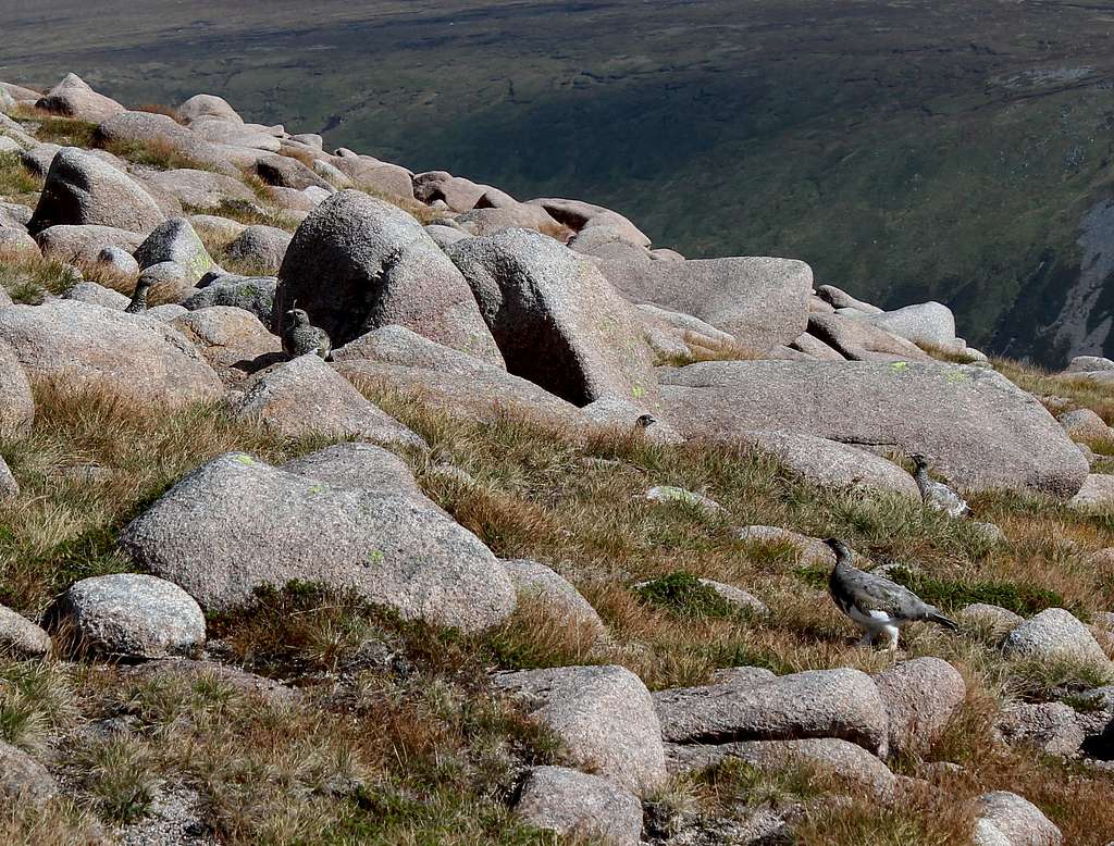
We left at 1.30 pm to head down, unforecasted clouds were forming in the west and we were too tired to think of taking in any further peaks. Not far from the summit, the rocks suddenly started moving.
“Ptarmigan.” I called to Marie. We watched as the perfectly camouflaged birds ran between the actual rocks, visible only when they moved.
We descended quickly down the same route, enjoying the views for one last time before reaching the car at around 4.40 pm.
Ptarmigan (Lagopus mutus)
"Recalled to life"
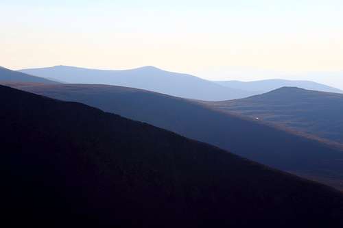
Northern corries, Cairngorms.
After such an enjoyable and successful trip, it was a shame to have to return to the normality of our lives. At least we both felt revived by the experience.
The Cairngorms had been better than we could have imagined. After months of wanting to travel to the mountains in mainland Europe, we had found a great alternative on our home soil. Although, this was my fifth visit to the area, it felt like the mountains were all new to me as I had never seen them in such favourable weather before. Some of the views we had seen had previously been hidden by banks of cloud and mist and the sheer vastness of the wilderness was larger than I had comprehended.
“We must try to come up to Scotland every year.” Marie said as we drove home.
I don’t know if we will manage that and I hope we will have some more great times but I doubt we will have a better trip to Scotland than this.
Hi Myles,
Many thanks for your comment. Yes, Scotland is a great place and has lots of variety. We really enjoyed this trip.
Take care and best wishes for 2022.
Mike
ryananderson - Feb 27, 2022 7:02 pm - Hasn't voted
Awesome!
Dam those pictures are stunning, I'd love to hike in scottland one day!
Many thanks for your comment, any photography skills I have are enhanced by the views I have to work with! Scotland has many beautiful areas to visit, I hope you get there someday.
Parents refers to a larger category under which an object falls. For example, theAconcagua mountain page has the 'Aconcagua Group' and the 'Seven Summits' asparents and is a parent itself to many routes, photos, and Trip Reports.


Comments
Post a Comment