|
|
Area/Range |
|---|---|
|
|
38.85682°N / 120.13°W |
|
|
Hiking, Mountaineering, Trad Climbing, Sport Climbing, Toprope, Bouldering, Ice Climbing, Aid Climbing, Mixed, Scrambling, Skiing |
|
|
Spring, Summer, Fall, Winter |
|
|
Overview
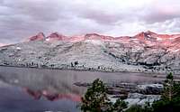
Due to it’s relatively easy access and proximity to large populations in the Bay Area, Sacramento, and Reno, Desolation Wilderness Area receives more use per acre than any other wilderness area in the U.S. But don’t let this scare you away from enjoying 64,000 acres (100 square miles) of subalpine and alpine forest, granitic peaks, meadows of wildflowers, 75 glacially-formed lakes with names, and countless ones without names. Desolation’s characteristic features, especially at the higher elevations, are the vast expanses of exposed granitic rock interrupted by sparsely scattered trees and shrubs. These are the result of the movement of glaciers, which scraped volcanic rock layers away to expose the underlying granite. It is located southwest of Lake Tahoe and north of Highway 50 in El Dorado County California.
Whether hiking or skiing, the open terrain in many parts of Desolation make cross-country travel easy, pleasurable, and quite scenic. Class 2 routes can get you almost everywhere in the wilderness area. Even on the largest peaks, more difficult parts can be easily avoided.

The most desolate part of Desolation is the large, glacially flattened basin that is the headwaters of Pyramid Creek in the southern part of the wilderness area. This area consists of bare granite slabs and boulders, scattered weather beaten trees, rollicking streams and numerous small and large lakes. Surrounded by the highest peaks in the area, the starkly beautiful Lake Aloha with its highly convoluted shoreline and hundreds of flat rock islands is the heart of Desolation.
The northern half of Desolation receives less use because the approaches are slightly longer and the peaks and lakes are not quite as dramatic as in the south. In the northwest the Rubicon River flows through the open exposed granite of the Rockbound Valley. The forest-covered northeast contains a chain of six glacial lakes on Meek’s Creek.
The Pacific Crest Trail and the Tahoe Rim Trail are one in the same as it takes a very scenic 22 mile tour of Desolation. The trail goes northwest from the Echo Lakes trailhead (7,400 ft.) for 2.5 level miles along the edge of Upper and Lower Echo Lakes. In the summer months, a water taxi crosses the lakes, making it an even easier hike into Desolation. Then the trail climbs thru shaded forest past Tamrack Lake to Haypress Meadows at 8,400 before dropping down past Lake Margery into the barren basin of Lake Aloha (8,100 ft.). The trail stays on Aloha's shoreline for 1.5 miles before turning east and climbing past Heather Lake, Susie Lake, Gilmore Lake, and Half Moon Lake to Dick's Pass (9,200 ft.). This is the trail's highest point in Desolation and the views to the north and south are outstanding. From the pass the trail descends past Dick's Lake, Fontanillis Lake, and Upper and Middle Velma Lakes to a saddle at 7,900 ft. Here the trail begins a 7 mile traverse to the area's northern boundary, at about 8,000 feet on the eastern side of Rockbound Valley, about 1,000 ft. above the Rubicon River.
Hazard's: Mosquitos are abundant in spring and early summer. Snow can hamper travel on higher parts of the trail well into July (or even all summer in wet years) and can return as early as October. Weather is unpredictable at all times.
Trailheads (counterclockwise from the north)
Ice House Road Trailheads on the west side of Desolation:
Loon Lake Trailhead, elevation 6,500 ft. A 6 mile hike starting along the southern edge of Loon Lake leads to the Buck Island Lake on the northern border of the wilderness area. Another trail ascends Tells Peak, but doesn’t connect to the rest of the wilderness area.
Buck Island Trailhead,elevation 6,500 ft. The famous 4-wheel drive, Rubicon trail passes Buck Island Lake. From here it is less than a half a mile across wilderness area’s northern boundary to Rockbound Lake, on the Rubicon River.
Van Vleck Trailhead. Elevation 6,600. Both of the 2 trails from this trailhead climb into the northwest corner of the wilderness area but do not connect to the main part of Desolation.
Rockbound Trailhead, At Wright’s Lake, elevation 7,000 ft., initial climb 1,500 ft. in 5.5 miles to Rockbound Pass.
Twin Lakes Trailhead, At Wright’s Lake, elevation 7,000 ft., trail doesn’t cross Crystal Range but is the quickest route to Pyramid and Agassiz Peaks.
Lyons Trailhead, Near Wright’s Lake, elevation 7,300 ft., trail ends and Lyons Lake and Lake Sylvia and doesn’t cross the Crystal Range.
Trailheads on Highway 50 on the south side of Desolation
[img:179419:alignleft:small:]<
Pyramid Creek (Twin Bridges/Horsetail Falls) Trailhead- $3 per vehicle per day. (This fee is waived for overnight permit holders.) elevation 6,000 ft. on Highway 50. The initial climb of 1,400 ft. in 2 miles includes a class 2 scramble up a talus slope to the top of Horsetail Falls.
Ralston Trailhead -elevation 6,500 ft. along Highway 50 above the Twin Bridges Switchbacks, initial climb 2,400 ft. in 3.5 miles almost to the top of Ralston Peak before dropping down towards scenic Lake of the Woods
Echo Lakes Trailhead -elevation 7,400 ft. at the eastern end of Echo Lakes, initial climb almost 1,000 ft. in 5.5 miles on the Pacific Crest/ Tahoe Rim Trail. This scenic trail follows Echo Lakes for the first two miles, then ascends past Tamarack Lake to the central part of Desolation.
Trailheads off of Highway 89 on the east side of Desolation
Glen Alpine Trailhead elevation 6,600 ft. at the southern end of Fallen Leaf Lake. Initial climb 1,200 ft. in 2 miles. Probably the quickest access to a variety of spots in the heart of Desolation.
Mount Tallac Trailhead elevation 6,500 ft. on the west side of Fallen Leaf Lake, initial climb 3,400 ft. to the top of Mt. Tallac.
Spring Creek Trailhead elevation 6,600 ft. Turn west on Spring Creek Road at the base of the long Emerald Bay switchback on highway 89. Stay left, then go right on Wiyot Road which dead ends at the trailhead. Prime access for skiing Mt. Tallac’s northeast bowl. It gets crowded on weekends and powder days so get here early.
Bayview Trailhead elevation 7,000 ft. on Highway 89 at the southwest end of Emerald Bay. Initial climb 1,200 ft. in 1.5 miles. Outstanding views of Lake Tahoe and Emerald Bay. Quick access to Dick’s and Jack’s Peaks and the basin of lakes north of these peaks.
Eagle Falls Trailhead $3 per vehicle per day. (This fee is waived for overnight permit holders.), elevation 6,600 ft. on Highway 89 at the west end of Emerald Bay. Initial climb 1,600 ft. in 2.6 miles. Quick access to Dick’s and Jack’s Peaks and the basin of lakes north of these peaks.
Meeks Bay Trailhead elevation 6,300, initial climb 1,300 ft. in 6 miles gets you to a chain of lakes in the northeastern corner of the wilderness area
Peaks
The major peaks in the Desolation Wilderness are Pyramid, Agassiz, Price (the Crystal Range), Jack’s and Dick’s and Tallac. All these have elevations between 9,700 and 10,000 ft., and are in the southern half of the area. Other noteworthy peaks with pages on Summitpost are: Ralston, Little Pyramid, EchoEcho, Eagle Lake Buttress, and Maggies.
Mt. Tallac (9,735 ft.) has the shortest access via trails from Glen Alpine Trailhead (5.4 miles 3,300 ft of climb) or Mt. Tallac Trailhead (4.4 miles 3,300 ft. of climb). Or make a direct class 2/3 scramble up the chutes from the Cathedral Lake Trailhead. The northeast ridge and bowl are more easily accessible in winter when snow covers the thick brush. In winter backcountry and telemark skiing are popular on Tallac’s northeast bowl from the Spring Creek Trailhead.
[img:84332:alignleft:small:]The Wright’s Lake Trailheads (Rockbound, Twin Lakes and Lyons) affords the easiest access to the peaks of the Crystal Range: Mt. Price (9,975), Mt. Agassiz(9,967 ft.) and Pyramid Peak(9,983 ft.) Trails via scenic mountain lakes will take you most of the way before some bushwacking and class 2 scrambling get you to the peaks. The route up the eastern side of these peaks from the Pyramid/Twin Bridges/ Horsetail Falls trailhead (6,000 ft.) is a slightly longer and has more climb. Pyramid peak is class 2 from this side while Agassiz and Price require some class 3 climbing on the east side.
In contrast to the light granite of the Crystal Range, Jack's Peak and Dick's Peak (less than a mile apart) consist of more colorful metamorphic rocks. Both peaks are accessible via class 2 routes including: Dick’s’s Peak from Dick’s Pass on the Pacific Crest/Tahoe Rim Trail or from the north ridge, Jack’s peak southeast slope and southwest ridge from Mosquito Pass. The ridge connecting Dick’s and Jack’s is also class 2.
Red tape
[img:141661:alignleft:small:]
Permits - Required year-round for both day and overnight use. There are fees for overnight camping year-round.
Group size - Limited to 12 people per party who will be hiking or camping together.
Day users - May obtain a free permit from one of the following offices, or may issue themselves a permit at most major trailheads in the summer. During the winter, day permits are available at the Pacific Ranger Station. Day use is not subject to fees nor limited by quota at any time of the year.
Quota - During the summer a quota is in effect on the number of people allowed into the wilderness. Refer to the Zone Quota page for more information.
Overnight Users - Must register in person and pay fees. Reserved permits are now mailed. Changes must be made in person and require the original permit to be turned in (fee may be required).
Reservation Fees: $5.00 per party/per permit (non-refundable). Permit fees are paid at time of reservation. Plan carefully before making your reservation as all fees are non-refundable.
Overnight Wilderness Permit Fee: $5.00 per person for one night, $10.00 per person for two or more nights up to 14 days (non-refundable). The cost of a single permit will not exceed $100.00. Children 12 and under are free. Golden passes do not apply to personal use permits.
Pre-Paid Fee Card: You can pre-pay your permit fees by purchasing this card for $20.00. The card covers only the overnight permit fee and is valid for one year from date of purchase. You must still obtain a permit in person, subject to quota limits.
Service Change: $5.00 for any change to the date or zone of your reservation or permit or for adding people. No fee for cancellations. Since reserved permits are now mailed out, changes to reserved permits must be made in person. Bring your original permit.
Parking Fee: Currently, only the Eagle Falls parking area on Highway 89 and the Pyramid Creek Parking area at Twin Bridges on Highway 50 have fees: $3 per vehicle per day. (This fee is waived for overnight permit holders. Be sure to obtain your parking pass, which exempts you from this fee when you pick up your overnight permit.)
Forest Parking Pass: A $20.00 Parking Pass is available and valid at the facilities listed below where a parking fee is required. This Pass is valid for one year from purchase date. Facilities include: Eagle Falls and Pyramid Creek trailheads, and Dru Barner Day Use Area year -round (as long as the facility is open). From May through October for Woods Lake, Carson Pass, and Meiss parking areas. (These are sno-parks during the winter.) Pass must be displayed in car window to be valid.
Permits can be obtained from :
Lake Tahoe Visitor Center
Located three miles north of the Highway 50/89 junction at South Lake Tahoe, on Highway 89. Open summer only. Call for hours, phone: (530) 573-2674
Eldorado National Forest Information Center
Located five miles east of Placerville on Highway 50.
3070 Camino Heights Drive, Camino, CA 95709
Phone: (530) 644-6048
Bears
Bear proof food storage containers are available for free rental from the Lake Tahoe Visitor Center or the LTBMU Supervisor's Office on the east side entry, while supplies last.
Keep a clean camp and never leave trash or food in the open and unattended.
Learn about area-specific food storage instructions and/or regulations.
Ask other campers or local employees about recent bear activity
Learn all you can about black bears and your safety before heading into the Sierra for vacation.
Campfires
Campfires are not allowed in Desolation Wilderness. Camp stoves are permissible.
Pets
Dogs must be controlled at all times.
Other Considerations
Livestock are limited to two livestock per person, or 12 livestock in one group. Do not hitch, tether, or hobble a horse or other saddle or pack animal within 200 feet of a water source or within 100 feet of a campsite.
External Links
U.S.Forest Service, Desolation Wilderness Page
Tahoe Area Campgrounds
Fly Fishing in Desolation
hgrapid - Aug 6, 2011 9:17 pm - Hasn't voted
New Forest Service websiteThere is a new website for the Forest Service for Desolation: http://www.fs.fed.us/r5/eldorado/recreation/wild/deso/
foweyman - Aug 6, 2011 9:36 pm - Hasn't voted
Re: New Forest Service websiteThanks, change made