
-
 82109 Hits
-
 92.03% Score
-
 37 Votes
|
|
Area/Range |
|---|---|
|
|
37.68940°N / 119.1981°W |
|
|
Hiking, Mountaineering, Trad Climbing, Ice Climbing, Aid Climbing, Scrambling, Skiing |
|
|
Spring, Summer, Fall, Winter |
|
|
Overview
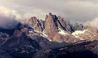
Storm clouds over the Minarets.
First established in 1964 as the Minarets Wilderness, the Ansel Adams Wilderness lies immediately southeast of--and contiguous to--Yosemite National Park. The 231,005-acre wilderness is a spectacular setting of alpine meadows, lakes, and rugged peaks that encompass the headwaters of the San Joaquin River. It is home to some of the most breathtaking scenery in the Sierra, if not the entire country. Indeed, likely for this very reason, the wilderness at one time was part of Yosemite. Unfortunately, mining interests meant it was removed from the park's jurisdiction in the early part of the 20th century. Fortunately, few claims were ever successful, and the area remains mostly pristine to this day.
Elevations within the wilderness range from 3,500ft, at Hells Half Acre along the Middle Fork San Joaquin River, to 13,157ft at the summit of Mt. Ritter. Like several other areas in the High Sierra, the area is home to spectacular wildflower displays in the spring, and equally impressive quaking aspen displays in the fall. Also found throughout the wilderness are abundant Red fir, Jeffrey pine, and some gorgeous stands of mountain hemlock at the higher elevations. Adding to the alpine feel, a number of small glaciers are found on the northern and northeastern aspects of the highest peaks.
The wilderness was renamed from the Minarets Wilderness to honour the famous landscape photographer and environmentalist by the 1984 California Wilderness Act. The 1984 law also more than doubled the size of the Minarets Wilderness, extending it south from its original southern boundary in the vicinity of Hemlock Crossing and Devils Postpile all the way to its current extent near Lake Thomas Edison.
Red Tape
The wilderness is jointly managed by Inyo National Forest, which manages eastern access to the wilderness, and Sierra National Forest, responsible for western access. Like most wilderness areas in the state, the area is subject to considerable red tape.
In addition to the usual wilderness regulations, wilderness permits are required for overnight stays, campfires are prohibited above 10,000ft, and bear cannisters are required if camping along the most popular trails. Camping is also heavily regulated around some of the most heavily visited lakes in the wilderness, including Shadow Lake and Lake Ediza. Current details can be found in the Inyo National Forest wilderness regulations. With one exception, detailed below, dayhikers can explore the area unencumbered by bureaucracy.
Given its outstanding scenery, the area is extremely popular with backpackers, and a quota system is in effect from May 1st through Nov 1st each year. 60% of permits are reservable ahead of time for a $5/person fee, while the remaining permits are obtainable free on a first come-first served walk-in basis, starting 11am the day before your hike. Contact the USFS ranger station responsible for your entry trailhead to procure the permit; this contact information can be found below.
Inyo NF: Quotas - permit reservations - availability.
Sierra NF: Quotas - permit reservations.
Eastern access to the wilderness via Minaret Road is subject to additional red tape, even for dayhikers. See the Agnew Meadows trailhead page for further details.
Contact Information

Lake Ediza.
Sierra National Forest
Contact the Sierra National Forest to obtain permits for entry from the west (Clover Meadow area trailheads):
Bass Lake Ranger District Office
559-877-2218 ext. 0
57003 Road 225
North Fork, CA 93643
Hours: 8:00 am to 4:30 pm
Yosemite Sierra Visitor Bureau
559-658-7588
41919 Highway 41
Oakhurst, CA 93644
Permit hours: Friday and Saturday, 8:30 am to 5:00 pm
Inyo National Forest
Contact the Inyo National Forest to obtain permits for east-side entry (June Lake and Devils Postpile area trailheads):
June Lake loop to Tioga Pass
Mono Basin Scenic Area Ranger Station and Visitor Center
760-647-3044
760-647-3045 TDD
P.O. Box 429
Lee Vining, CA 93541
Hours: 9:00 am to 4:30 pm
Closed in winter
Reds Meadow to Agnew Meadows
Mammoth Ranger Station and Visitor Center
760-924-5500
760-924-5531 TDD
P.O. Box 148
Mammoth Lakes, CA 93546
Hours: 8:00 am to 5:00
Open all year, 7 days a week
When To Visit
Most people visit the Ansel Adams Wilderness during the summer and fall months, typically June through October. Visitation is heaviest during July and August, once most of the snow has melted and all access roads are open. Summer thunderstorms are relatively common during these months.
Winter and early spring climbs are possible, but access to the wilderness is considerably more difficult. All access roads from the west are closed at this time of year, necessitating a very long (20+ mile) approach just to reach the usual trailheads. Access from the east is also more difficult, as road closures again require a longer approach than in the summer. See individual trailhead information for further details.
Current Conditions
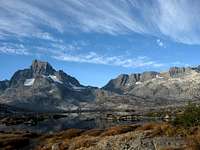
Thousand Island Lake.
Sierra National Forest
Bass Lake webcam - Bass Lake Ranger District recreation report (campground information/road conditions)
Inyo National Forest
Mammoth Lakes webcam - Mammoth Lakes/Mono Basin recreation report
Maps
In addition to the usual USGS 7.5' topographic maps covering the wilderness, a number of other area maps can be useful.
National Forest maps
Sierra National Forest and Inyo National Forest both publish maps showing forest trails, roads, and land ownership within their areas of jurisdiction. These two maps are not suitable for hiking or climbing purposes, but they are very useful for locating obscure Forest Service roads and area campgrounds.
Topographic maps
The Forest Service publishes an excellent topographic map (1:63360) entitled A Guide to the Ansel Adams Wilderness.
Tom Harrison Maps publishes a series of waterproof topographic maps . (1:63,360, 80-foot contours) that covers the entire Eastern Sierra. This unfortunately doesn't cover the Ansel Adams Wilderness in its entirety, but two of the maps suffice to cover the areas most of interest to climbers: Mammoth High Country and Mono Divide. These maps are particularly useful for planning as they include trail mileages.
Where to buy
Forest Service maps can be bought over the phone or through the mail from the National Forest Store. Tom Harrison Maps can be ordered online from the company's website (see link above), or found in most outdoors stores.
Books
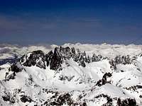
Late-season snow on the Minarets.
Climbing-related
RJ Secor, The High Sierra: Peaks, Passes, and Trails - the bible of the High Sierra. Covers trails, cross-country routes, and peaks throughout the area.
Steve Roper, Climber's Guide to the High Sierra - a predecessor to Secor's book. Terse route descriptions and occasionally "old-school" (some may say sandbagged) ratings, but can include some valuable nuggets of information not found in Secor's guide.
John Moynier and Claude Fiddler, Sierra Classics: 100 Best Climbs in the High Sierra - brief route descriptions for an interesting and varied selection of climbs, all mixed in with some entertaining anecdotes. Covers routes throughout the Sierra, with several chosen from the Ritter Range in the heart of the Ansel Adams Wilderness.
General reading
Ginny Clark, Ansel Adams Wilderness - a good guide to the trails, lakes, fauna, and flora of the wilderness.
George Wuerthner, California's Wilderness Areas, The Complete Guide Vol 1: Mountains and Coastal Ranges - the first volume in a two book series covering all wilderness areas in the Golden State. He provides a brief overview of each wilderness, and includes just enough information to whet the reader's appetite for a visit.
External Links
Wilderness.net description
Ansel Adams biography and further reading.