
-
 17399 Hits
-
 84.82% Score
-
 19 Votes
|
|
Area/Range |
|---|---|
|
|
43.62720°N / 110.4653°W |
|
|
Hiking |
|
|
Spring, Summer, Fall |
|
|
9000 ft / 2743 m |
|
|
Overview
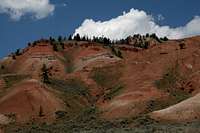
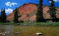
Shortly after the dawn of the twentieth century, a bitter feud between two Jackson Hole ranching families erupted into a vicious physical conflict that resulted in so much bloodshed that the slopes of some of the hills where the fiercest fighting occurred were stained red until heavy rains came. And thus the Red Hills got their name.
Okay, that was just to get your attention. The real reason the Red Hills are named as they are is because they are, well, red.
East of the world-famous Teton Range, just beyond the boundary of the national park and north of the unsung Gros Ventre Range, lie the Red Hills and the Lavender Hills. The Red Hills form the southern edge of a sprawling, little-visited region called the Mount Leidy Highlands that connects the Gros Ventre Range to the Absaroka Range. This remote area serves as an important wildlife corridor for some of the large game of northwestern Wyoming, including grizzly bears, but it is largely unprotected and has been targeted for extensive oil and gas extraction.
The Red Hills make a stunning sight as one crests a rise on the Gros Ventre Road and begins descending toward them. Suddenly, one feels a world away from the soaring Tetons and enveloped in scenery s/he never expected to see in Wyoming. No, Wyoming is not just the Tetons and geysers, and it takes surprisingly little effort to find that out.
After gawking at the brilliant reds that jump out from their surroundings, take a closer look at the slopes and try to spot bighorn sheep maneuvering on the rocks. Look up and around for eagles and hawks. Examine the sagebrush flats for lizards and snakes. And if you’re lucky, you’ll see a tough badger going about its business. The hills are alive…

Hiking Route: Although the Red Hills are easy to appreciate just from the car, there are some trails leading into them. The shortest, which nevertheless has a nice payoff, starts about 100 yards east of the entrance to Red Hills Ranch (there is no missing the ranch). The trailhead isn’t marked with a signboard or register, but look for the path and some markers indicating closures to motorized vehicles. If you reach the Red Hills Campground, you have gone too far. The fact that the trailhead is in between the ranch and the campground, which are close together themselves, makes it relatively painless to find.
The trail is 3 miles RT and climbs about 1100’. It will likely be hot in the summer, so carry plenty of water even though the trail isn’t a long one. The trail starts by crossing a grassy flat to the mouth of a small canyon, then follows the canyon floor, and turns left (west) below the head of a draw. After that, the trail leads through some groves of Douglas Fir and eventually reaches an overlook of the Tetons that will be free of the tripod-brandishing crowds at the national park’s roadside pullouts. Hike early in the morning for the best colors on the hills and for the best views to the Tetons.

 By thephotohiker
Getting There
 By thephotohiker
From the North: Turn left (east) from U.S. 26/89/187 through Grand Teton National Park onto a paved road (Antelope Flats Road) that is just past the Blacktail Ponds Overlook. If you reach Moose Junction, you have gone too far. Drive about 5 miles to an intersection with another narrow paved road and turn right. At the intersection, there should be a sign indicating that one turns right to reach Kelly. After 2-3 miles of driving south, turn left onto the Gros Ventre Road. If you reach the small community of Kelly or the Gros Ventre Campground even further, you have gone too far and have to turn around.
From the south: From Jackson, take U.S. 26/89/187 through Grand Teton National Park north to Gros Ventre Junction, where you turn right onto a paved road leading to Kelly. At the turnoff to Kelly, the road turns sharply left (north) and reaches the Gros Ventre Road in about 2 miles. Turn right onto that road.
Gros Ventre Road: Some maps mark this as an unpaved road, but it is paved, though not very well, for a few miles. Signs will indicate it is 10 miles to the Red Hills, but it is closer to 11, at least to reach the heart of the area. Along the way, you pass the Gros Ventre Slide (where a section of a mountain collapsed) and Lower Slide Lake (created by natural damming resulting from the slide). The road is easily passable for most cars to the Red Hills area but does have a good deal of washboarding that will mess with traction for vehicles that have light rears or which are going too fast. After the Red Hills, the road makes a bridged crossing of Crystal Creek and starts getting rougher as it heads into sprawling, open Wyoming country that is like something out of a Western.
Red Tape
No red tape, but do notice and respect private property in the area.Camping
 Scene from Red Hills Campground-- by thephotohiker
Camp at Red Hills Campground (administered by the Forest Service, fee, no reservations) near the eastern end of the Red Hills (about 12 miles along the Gros Ventre Road) or at Gros Ventre Campground (administered by the National Park Service, fee, no reservations) back on the Kelly Road near Gros Ventre Junction. The latter campground, though in the national park, is large and far from the busy trailheads and thus rarely fills.
External Links
Check for any information about closures, wildfire information, campground opening/closing dates, etc.Bridger-Teton National Forest
Grand Teton National Park Site