

|
|
Mountain/Rock |
|---|---|
|
|
40.79490°N / 111.8413°W |
|
|
Salt Lake |
|
|
Hiking |
|
|
Spring, Summer, Fall, Winter |
|
|
6291 ft / 1917 m |
|
|
Overview
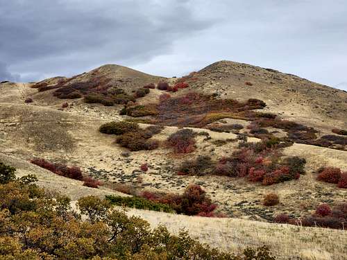
There are three sets of "Twin Peaks" in the Salt Lake Valley. They are American Fork Twin Peaks, the Broads Fork Twin Peaks, and the Avenues Twin Peaks. The USGS maps simply label all of these peaks as "Twin Peaks, but the prefix names are usually used to distinguish them one from another. This pair of Twin Peaks are the lowest and by far the easiest to climb of the three. These peaks are an excellent short climb, and can be hiked in all four seasons. The peaks sit on the ridge separating City Creek Canyon and Dry Creek. The trails are very popular with runners and hikers. Round-trip time is generally only a few hours for most hikers.
Although these peaks are very low in elevation compared to the other Twin Peaks, the views of the valley are really nice. Both peaks are a short walk from one another. This would make a good night hike with the city lights twinkling below. The mountain is generally snow-free from April to November, but summer heat along the barren west ridge makes it less than desirable hike when temperatures are high.

Getting There
There are four commonly used trailheads.
The most common way of climbing Avenues Twin Peak is via the west ridge from the Salt Lake City avenues.
Valleyview Drive
Head east along North Temple into the avenues and turn left on I Street and follow the incredibly steep road all the way to the top, and follow the main road which angles left (west) for a short distance before turning 180 degrees and heading back east towards the mountains. As you approach the mountains, the road turns south and dips. Turn left at Terrace Hills Drive and park at the top of the road. The trail is well marked and there is ample room for parking.
The mountain can also be climbed from Dry Creek to the south, which merges with the west ridge higher up, or via Smugglers Gap in City Creek Canyon.
Avenue Twin Peaks (right), seen from the trail coming up from Terrace Hill Drive.
Morris Reservoir
This trailhead is not far west of Valleyview drive above.
Dry Creek
Dry Creek Canyon is reached by way of the Jewish Community Center and the University of Utah Medical Center. It is recommended that public transportation be used to reach this trailhead if at all possible. The Campus shuttle, UTA, and Trax all reach the vicinity of the trailhead.
Driving Directions
From Foothill Boulevard and Sunnyside Avenue (800 South) head north on Foothill Boulevard to the second traffic light (Wasatch Drive). Turn right onto Wasatch Drive and drive through the next traffic light (South Campus Drive) and continue north until Wasatch Drive ends at North Campus Drive. Turn right (east) onto North Campus Drive and proceed east through the traffic light and soon after turn left (north) into the Jewish Community Center parking lot opposite the entrance to the University Medical Center. Please limit your parking to the east end of the lot and don't abuse the privilege of this off-street parking.
City Creek Canyon
Recent maps show trails up Avenues Twin Peaks from City Creek Canyon. I am not familiar with these routes.
Routes Overview
Valleyview Drive/Valleyview Canyon Route
This is probably the most used route up to the summit. The trail is obvious the entire way, though there are many branches. The first two thirds of the main route to the summits is part of the Great Western Trail. Once the Great Western Trail reaches the ridge and starts to contour the slope, leave the Great Western Trail and continue along the ridge to the summit. This route is just under four miles round trip and with about 1000 feet of elevation gain.
Morris Reservoir Route
This route is slightly longer than the one from Valleyview Drive, but is almost the same route. From the trailhead, trails head north and east to the Great Western Trail, thus meeting the Valleyview Drive Route above. This route is about four miles round trip and with 1000 feet elevation gain.
Dry Creek Route
From the mouth of Dry Creek, follow the Great Western Trail up Canyon to the confluence of the two forks. Follow the Great Western Trail to the left and up the North Fork. The Great Western Trail then leaves the North Fork and then contours the slope around the vicinity of the peaks. There is another possible route from the North Fork as well. Where the Great Western Trail leaves the North Fork, an unofficial trails go both up the North Fork and also up a minor drainage directly north and to the ridge. The path heading north reaches the ridge not far east of Twin Peaks. It is easy to make a six mile loop using both routes.

Red Tape
There are no red tape issues if climbing Avenues Twin Peaks from either the standard west ridge trail or Dry Creek.
It's been my experience that City Creek Canyon access is difficult. You'll need to obtain a pass to get to the higher parking lots, which are only open certain days of the year. There seems to be constant construction going on in recent years. Bikers could bike the five miles past the main guard station to the end of the pavement to begin hiking towards the Smugglers Gap trail.
Camping
All hikes in this area are generally done as day hikes, but you could certainly find camping spots along flat sections of the ridges.
When to Climb
Summers are hot, making spring and fall the ideal times to climb the mountain. In summer, get an early morning start and climb in the mornings. Often in winter, there isn't much snow on the mountain, especially during a long dry spell.
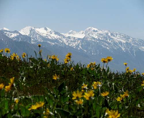
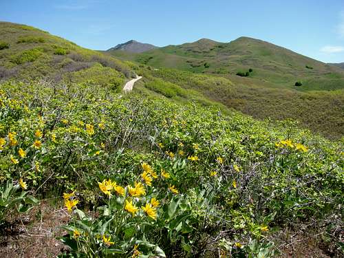
Alpine Ridge seen from one of the Avenues Twin Peaks in May.
Mountain Conditions
CLICK HERE FOR AVENUES TWIN PEAKS WEATHER FORECAST
Weather and climate data for Parleys Summit at 7585 feet elevation is below. *SNOTEL Data 1985-2017. Expect conditions on the summit Avenues Twin Peaks to be about 3 degrees or so warmer.
| MONTH | AVE HIGH | AVE LOW | REC HIGH | REC LOW | AVE PRECIP (in) |
| JAN | 35 | 19 | 58 | -14 | 3.6 |
| FEB | 38 | 20 | 62 | -19 | 3.4 |
| MAR | 45 | 25 | 69 | -6 | 4.0 |
| APR | 50 | 30 | 74 | 4 | 3.6 |
| MAY | 58 | 38 | 83 | 15 | 2.9 |
| JUN | 69 | 47 | 94 | 24 | 1.7 |
| JUL | 77 | 55 | 96 | 35 | 1.0 |
| AUG | 76 | 53 | 95 | 33 | 1.3 |
| SEP | 67 | 45 | 91 | 21 | 2.3 |
| OCT | 54 | 36 | 78 | 3 | 3.1 |
| NOV | 42 | 25 | 68 | -9 | 3.8 |
| DEC | 34 | 18 | 61 | -12 | 3.7 |