
|
|
Mountain/Rock |
|---|---|
|
|
41.22425°N / 111.91052°W |
|
|
Weber |
|
|
Hiking, Scrambling |
|
|
Spring, Summer, Fall, Winter |
|
|
7017 ft / 2139 m |
|
|
Overview
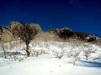
Approaching Dome
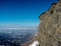
View from the top
Hidden Valley Dome (unofficial name), is a 7017 ft point that looks like a high dome overlooking Ogden near the Hidden Valley Trail. It is the round, rocky summit you see across the valley from Malan Peak. While not the highest summit overlooking Ogden (that would be Mt Ogden), Hidden Valley Dome can be a reasonably formidable 1/2 day round hike/climb with a 2,400 foot gain. It is especially fun in the winter and will get you above Ogden's nasty inversion cloud. Total round trip distance is about 4 miles and total round trip time is approximately 3 hours.
The Route

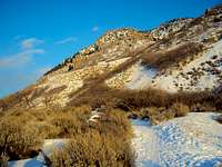
View to the Southeast (Photo Imontop)

Hidden Valley Painted on rock--easy to miss!

Trail along West Face of Mountain
The most common route to Hidden Valley Dome's summit can be broken into four segments.
The 1st segment of the hike starts at Ogden's 22nd Street trailhead. Follow Indian trail up the West face of the mountain for about 20 minutes until you spot a rough trail going South--Look carefully, as it is easy to miss. The trail is located at Long/Lat 41.232413,-111.922402 and faces west.
For the 2nd segment, leave Indian Trail at about .70 miles. There used to be a rock with "Hidden Valley" painted on it, but someone has painted over it. You need to look carefully for the trail as it is a little hard to see. The trail heads south off of Indian up some rocks. Hidden Valley Trail generally south and east, up a series of switchbacks and roughly south for about 20 minutes until you reach a flat crag overlooking Ogden.
The 3rd segment is from the crag and the trail proceeds generally east. This 20 minute segment goes up 3 fairly steep areas (actually not THAT steep, they are, however, ice sheets in the winter and slick, muddy quagmires in the spring!) of trail. After the steeps, you will be on another overlook crag (again great views of Ogden) and Hidden Valley Dome will be to your north.
The final segment is a bushwhack/scramble through the scrub brush up to the dome's "rock castle" after leaving the Hidden Valley Trail. Few people climb Hidden Valley Dome, so there isn't a beaten path. On the other hand, the easiest approach is from the south and the vegetation isn't really that thick. After the bushwhack, all that is left is figuring out how to climb the 25 feet of rock to the top. There are several approaches, pick the one that is best suited for your skill.
Summer ascents are hot and dry. Strongly recommend bringing plenty of water as there isn't a place to resupply along the route. In addition, the trees are pretty thick on the final bushwack segment during the summer. Spring/fall hikes are best on clear, dry days to avoid mud filled, steep trails.
During the winter, you shouldn't need snowshoes up to the 2nd overlook if it hasn't snowed in a couple of days because the trail will be fairly well beaten down. You probably will need light crampons like "yak-tracks" for safe ascents up the "steeps". If you are the 1st to go up after a snow, it's either wear snowshoes or posthole the entire way. The final off-trail bushwhack can be done without snowshoes if you don't mind slogging through hip-deep snow up a really steep slope, otherwise snowshoes would definitely come in handy.
The rock climb to the top is doable without special equipment but can be a little sporty in the winter. Be careful!
Getting There
From Trail Head
The Trailhead is located where 22nd Street ends at the foot of the mountains (otherwise known as the "22nd Street Trailhead--see 22nd Trailhead Summitpost info page). Lat/Long is 41.226595,-111.930739.
From I-15, take the 12th Street exit, follow it until you reach Harrison Blvd, take a right onto Harrison, follow Harrison until you reach 22nd street, take a left toward the mountains, follow 22nd street until it ends at the base of the mountains.
The parking lot is large, paved and has room for about 15 vehicles. It is large enough to accommodate horse trailers. The lot has a sign saying it closes after dark, but I’ve never actually have seen it close. There is an information Kiosk located at the trailhead with a topographical map and safety information.
No water or restroom facilities are available at the trailhead (nor along the trail), so plan accordingly.
Camping
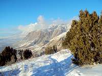
Lewis Peak to the North
There are very few desirable locations on the route to Hidden Valley Dome. There are, however, ample good primitive camping spots if you continue on Hidden Valley Trail into the high canyon and through the forest. In addition, there are intermittent small streams in the forest to do water resupply (don't count on them in the summer).
Be extremely careful with your campfires in area as they can get out of control very quickly. You will note evidence of numerous occasions where grass fires previously swept up the hillsides. Fire is dangerous; be careful.
Red Tape
None, you are on USFS land the entire hike.Flora and Fauna
The usual Utah animals live in the area around Hidden Valley Dome. Along the way, you may see Sage Grouse, Fox, Deer, Moose, Owls, Rabbits and Squirrels in the area. Both eagles and vultures glide along the mountain side and will get in close enough for a good look. In addition, keep your ears and eyes open for rattlesnakes (especially during the bushwhack) as this is a great habitat for them in the spring and summer.The area immediately adjacent to the trail is dry, west facing rocky mountainsides. It takes a little hiking to reach actual “forest”. In the dry area, flora is mostly sage brush and bunch grass. During spring/summer, you can find a nice variety of wildflowers. The woods, when you do reach them, are mostly made up of Gambel oak and Canyon Maples.