

|
|
Mountain/Rock |
|---|---|
|
|
40.82200°N / 111.771°W |
|
|
Salt Lake |
|
|
Hiking |
|
|
Spring, Summer, Fall, Winter |
|
|
8040 ft / 2451 m |
|
|
Overview
Little Black Mountain (simply "Black Mountain" on the USGS Quads)is one of the best kept secrets in the Wasatch Mountains. It's elevation is low compared with other peaks in Salt Lake County, but the scenery is outstanding (especially in spring when the wildflowers are in bloom) and the short scramble along the summit ridge offers "character" other lesser Wasatch peaks lack. It's proximity to downtown is amazing. You can literally be at the trailhead from downtown in five minutes. The views of Salt Lake City are great.The mountain is generally snow-free from early May to November, but summer heat along the barren west ridge makes it less than desirable hike when temperatures are high.
Little Black Mountain sits on the prominent ridge seperating City Creek Canyon and Red Butte Canyon. It is popular with runners, and the site of the Wasatch Steeplechase run every summer. The ridge continues east from Little Black's summit all the way to Lookout Peak (8,954').
Big Black Mountain (8,958') sits on the ridge to the north, really nothing more than a sub-peak along the ridge to Grandview Peak (9,410'), the highest peak in the area.
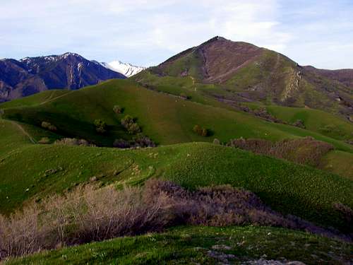 Little Black Mountain from the west.
Getting There
There are four commonly used trailheads.The most common way of climbing Little Black Mountain is via the west ridge from the Salt Lake City avenues.
Valleyview Drive
Head east along North Temple into the avenues and turn left on I Street and follow the incredibly steep road all the way to the top, and follow the main road which angles left (west) for a short distance before turning 180 degrees and heading back east towards the mountains. As you approach the mountains, the road turns south and dips. Turn left at Terrace Hills Drive and park at the top of the road. The trail is well marked and there is ample room for parking.
The mountain can also be climbed from Dry Creek to the south, which merges with the west ridge higher up, or via Smugglers Gap in City Creek Canyon.
 Little Black Mountain from the summit of Avenues Twin Peaks, which is located above the Valleyview Drive, Morris Reservoir, and Dry Creek Trailheads.
Morris Reservoir
This trailhead is not far west of Valleyview drive above.
Dry Creek
Dry Creek Canyon is reached by way of the Jewish Community Center and the University of Utah Medical Center. It is recommended that public transportation be used to reach this trailhead if at all possible. The Campus shuttle, UTA, and Trax all reach the vicinity of the trailhead.
Driving Directions
From Foothill Boulevard and Sunnyside Avenue (800 South) head north on Foothill Boulevard to the second traffic light (Wasatch Drive). Turn right onto Wasatch Drive and drive through the next traffic light (South Campus Drive) and continue north until Wasatch Drive ends at North Campus Drive. Turn right (east) onto North Campus Drive and proceed east through the traffic light and soon after turn left (north) into the Jewish Community Center parking lot opposite the entrance to the University Medical Center. Please limit your parking to the east end of the lot and don't abuse the privilege of this off-street parking.
City Creek Canyon
Recent maps show trails up Little Black Mountain from the end of the road and the City Creek Meadows Trailhead and from just west of Pleasant Valley Reservoir. I am not familiar with either of these routes.
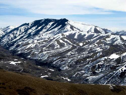 In the photo are City Creek Canyon and Little Black Mountain.
Routes Overview
Morris Reservoir and Valleyview DriveBoth of these routes converge after a short distance. The routes follow the west ridge of Little Black Mountain, passing Avenues Twin Peaks along the way. Most people stop at the first false summit along the ridge, but the true summit is farther east. There is some class 3 scrambling required to reach it. This route is 9.6 miles round trip with 3100 feet of elevation gain.
 A scene along the trail to the summit.
Dry Creek
There are several route variations here. You can follow the Bonneville Shoreline Trail around to the other two route mentioned above, but this is not the shortest route.
Dry Creek divides a short distance up canyon. A faint in places trail ascends the ridge between the two forks and eventually to the West Ridge of Little Black Mountain.
Another possible route is to take the Left Fork of Dry Creek and ascend the ridge on a lesser used trail when the Bonneville Shoreline Trail makes a sharp left and heads southwest. This lesser used trail reaches the West Ridge of Little Black Mountain not far east of Avenues Twin Peaks.
The two latter routes mentioned above are about the same distance and elevation gain than the routes from Morris Reservoir and Valleyview Drive.
 Looking west from the summit of Little Black Mountain.
Red Tape
There are no red tape issues if climbing Little Black from either the standard west ridge trail or Dry Creek.It's been my experience that City Creek Canyon access is difficult. You'll need to obtain a pass to get to the higher parking lots, which are only open certain days of the year. There seems to be constant construction going on in recent years. Bikers could bike the five miles past the main guard station to the end of the pavement to begin hiking towards the Smugglers Gap trail.
Camping
All hikes in this area are generally done as day hikes, but you could certainly find camping spots along flat sections of the ridges.When to Climb
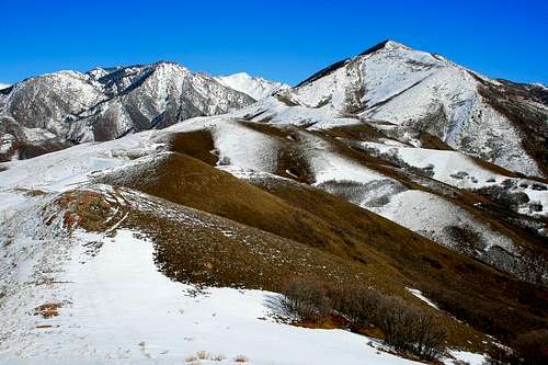
As mentioned, summers are hot, making late spring and early summer and fall the ideal times to climb the mountain. Little Black Mountain makes a safe winter ascent as well, though snowshoes will likely be needed on the upper slopes. Little Black Mountain in winter.
Mountain Conditions
CLICK HERE FOR WEATHER FORECASTBelow is the National Weather Service Climate Summary of the old Park City Summit House. The data is from 1969-1977. The old Park City Summit House was at 9280 feet elevation, so expect the temperatures and weather averages on Little Black Mountain to be quite similar, but a few degrees warmer.
| MONTH | AVE HIGH | AVE LOW | REC HIGH | REC LOW | AVE PRECIP (in) | AVE SNOW (in) |
| JAN | 24 | 12 | 46 | -17 | 3.51 | 48.7 |
| FEB | 28 | 14 | 44 | -10 | 2.99 | 48.8 |
| MAR | 30 | 14 | 51 | -9 | 3.05 | 47.0 |
| APR | 39 | 21 | 61 | 1 | 2.81 | 39.8 |
| MAY | 50 | 32 | 67 | 10 | 1.67 | 10.3 |
| JUN | 61 | 43 | 80 | 20 | 1.13 | 3.1 |
| JUL | 69 | 51 | 79 | 36 | 1.10 | 0.0 |
| AUG | 68 | 50 | 79 | 30 | 1.10 | 0.0 |
| SEP | 57 | 39 | 75 | 13 | 1.15 | 1.5 |
| OCT | 42 | 28 | 64 | -2 | 2.83 | 24.5 |
| NOV | 32 | 20 | 54 | -14 | 2.83 | 38.1 |
| DEC | 26 | 13 | 45 | -12 | 3.49 | 54.5 |