
|
|
Mountain/Rock |
|---|---|
|
|
41.08827°N / 111.89292°W |
|
|
Davis |
|
|
Hiking |
|
|
Spring, Summer, Fall, Winter |
|
|
6689 ft / 2039 m |
|
|
Overview

Sun rise near the Layton nipple -- Photo by IMONTOP
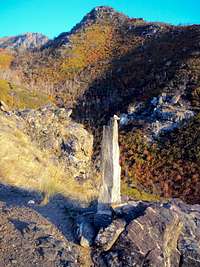
Oblisk on Route at 1/2 way point

View of the Layton Nipple from the Community Trail
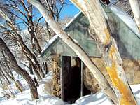
The Stone Cabin North of the Layton Nipple
Highpoint 6,689, commonly known as the "Layton Nipple", is sporty little hike above Kayscreek/Fernwood trailhead near Layton Utah. While not technically a peak (prominence is about 120 feet), the highpoint stands out above the Kayscreek/Fernwood trailhead with 500 foot drops on three sides and a dramatic view of the Wasatch plain below. It is a great winter destination when the days are short and/or the weather foul. The trip can be either defined as a difficult hike or a easy climb that involves steep hiking, bushwhacking and scrambling. Most of the hike is YDS class 1 with areas reaching YDS 2 or 3. The best time to climb this hill is winter, early spring, or late fall.
The trail is an approximately 4 mile (round trip) route that follows the "Community Trail" (non-USFS sanctioned trail) steeply up the side of the mountain and goes past the "Layton stone cabin". The trail to the stone cabin is steep and rugged but well defined. The hike past the Stone Cabin and across the hillside is not recommended for summertime because, once you reach the stone cabin, you'll have to bushwhack through about a third of a mile of dense Gambel oak forest.
The route starts at 5,120 feet (at Kayscreek/Fernwood Trailhead near the Layton Castle) and reaches the rocky highpoint at 6,689 feet (1,569 foot gain). Trail traffic is sparse and most of the time you'll have the entire trail to yourself. It takes about an hour (average hiker time) to reach the stone cabin and another 45 minutes to bushwhack across the mountainside and up the traverse to the top.
Should you decide to go during the summer, mornings and evenings are the best times to hike as the west-facing trail gets a good deal of sun--it gets hot; bring water. The stone cabin does have a water pipe tapped into the mountain, so resupply may be possible.
Shoe shoes are near mandatory for winter hikes, especially on the hillside and traverse to the summit beyond the stone cabin. Once leaving the trail the snow is at usually knee deep and drifted to chest deep in places. You can expect at least some snow into early May but will probably only need snow shoes into April.
Overall, the trail portion is straight forward. Park in the USFS Kayscreek /Fernwood trailhead parking lot and proceed North on the Great Western Trail. Community Trail splits off and goes east almost immediately...about 50 yards into the hike! (It is however, the 2nd split off, there is another split about 25 yards into the hike marked with a Bonneville Shoreline Trail marker).
Community Trail first appears to be an abandoned Jeep trail as the trail goes east. After about a 1/4 mile, the jeep trail peters out and it becomes a regular hiking trail. Cross the stream and follow the trail---you can see Hill 6,689 for almost the entire hike after you climb the first hill after the creek, so it's nearly impossible to get lost. At about 1 mile, there is a stone obelisk that marks the halfway point to the stone cabin. Continue following the trail east and up crossing another small stream (frozen in winter, dry in summer).
At 1.70 miles there is a stone cabin about 50 yards in the forest right of the trail (very difficult to see in the summer). The Layton Nipple will be directly across from you and you can see the small saddle and the best approach to the top. Leave the trail, cut across the hillside through the forest to the saddle and head up. It's only about a 1/3 mile across the hillside, but it can be a real bear in the summer--the brush is thick!
Finally, once you reach the saddle, continue scrambling up the traverse to the top. Even though there isn't a trail, you'll pass a well constructed (but primitive) hunter's camp on the traverse. You’ll have to do some minor rock climbing to reach the summit but 6,689 pays off with great views of the area.
NOTE: For Geocaching summitposters, there is a Geocache located in the rocks next to the summit
Getting There

View from the Summit looking East --- photo by IMONTOP

Route Map to 6689

View from the Summit
Trailhead is located at 41.087794,-111.901846
From I-15 Take the Antelope drive exit and head east (toward the mountains)for 2 miles. Turn right onto N Fairfield Rd for 0.7 mile and then take the 2nd left onto Cherry Lane. Follow Cherry Lane for 2.1 miles until you reach Highway 89. Cross Highway 89 (there should be a Sinclair Gas Station and Grounds for Coffee here) and turn left onto Valley View Drive for .5 miles. Turn right onto Fernwood Drive for .5 miles and continue past the "Layton Castle" into Fernwood Park. Park in the USFS parking area.
The trailhead has water and restrooms available. There is room for about 20 vehicles and great parking for horse trailers. Since the trailhead is the nexus for 3 different trails (Great Western, Bonneville Shoreline and Community) the parking lot may be full on pretty days. In that case, park on the street across from the Castle.
During the winter, the gate may be closed due to snow, so you'll have to park across the street from the Castle. The gate also closes at sunset, so unless you want to spend the night, you might want to leave before the gate is locked. It normally doesn't open until 0800 in the mornings.
Red Tape

Bushwacking along traverse
USFS land, no fees. Dogs/horses are allowed.
Being USFS land, be sure to abide by the usual regulations inherent to
government property. In addition, since Community Trail is non-sanctioned, the USFS highly discourages improving or even maintaining the trail.
Camping

Green in Spring (photo Imontop)

Hunter Camp near summit
There are two good spots to camp on the trail. You can overnight in the stone cabin and there is a primitive camping area on the traverse to the Nipple. Neither of these two spots is near a water source; all drinking material must be packed in. Be extremely careful with campfires, especially during the summer--the canyon still has evidence of numerous forest fires (the last one in 2006 and now just growing over).
Other Websites
http://www.localhikes.com/Hikes/AdamsCabin_7160.asp?ReviewPage=2
http://www.trailbehind.com/Fernwood%20Cabin%20Trail/
https://www.summitpost.org/layton-peak/317386
http://www.co.davis.ut.us/discoverdavis/recreation/hiking.cfm
http://www.bonnevilleshorelinetrail.org/
Flora And Fauna
Most of the trail is on west-facing mountainside and has sage brush, bunch grass, some small cactus and wildflowers. Near the lower creek crossing there is Water Birch, Gambel Oak and ferns. The forest across the hillside is Gambel Oak.
Animal life consists of grouse, deer, elk, rabbits, and fox. You’ll also see a lot of song birds along the way if you go in the summer. I haven’t seen any evidence of large predators and, because it’s close to town, there probably aren’t many. There doesn’t seem to be too much of a mosquito problem but DEET always comes in handy.