

-
 8935 Hits
-
 89.39% Score
-
 29 Votes
|
|
Mountain/Rock |
|---|---|
|
|
45.55470°N / 7.05420°E |
|
|
Mountaineering |
|
|
10547 ft / 3215 m |
|
|
Overview
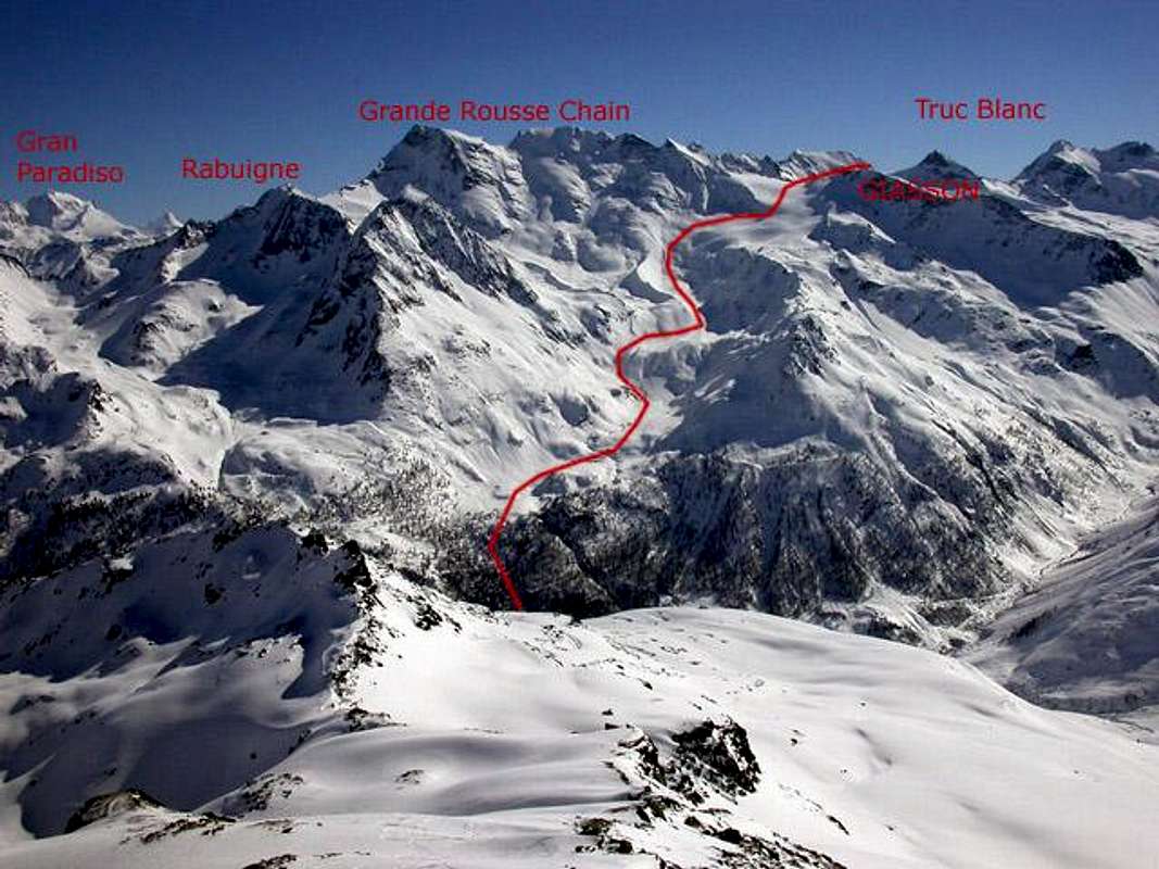
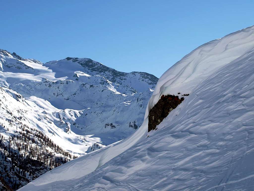
Ski mountaineering from Usellieres to Giasson summit, seen from Mont de l'Arp Vieille
Becca di Giasson (3.215m) is a minor summit close to Grand Rousse (3.601m). Maybe it is not such a wonderful ledge on other Aostan peaks, but its large and variable Northern slopes are good enough to have a full day of funny ski during late season.
As all other ski-mountaineering hikes in higher Valgrisenche, the starting point (Usellieres, 1.785m). is reachable only when the "Ring Road" around Beauregard Lake, actually again a dam, is free from snow. This happens, generally, on early/late May.
Avoid this summit before road opening, because heliski breaks all day long. I don't like'em at all, then I refuse to give you information how to contact this "organization" for their own business ...(Translation from text by Buxlex).
La Becca di Giasson (3.215 m) è una vetta minore vicino alla Grand Rousse (3.601 m) Forse non è una magnifica sporgenza su altre vette valdostane, ma i suoi versanti Settentrionali ampi e variabili sono abbastanza adatti ad avere un'intera giornata di sci divertente durante la tarda stagione. Come tutte le altre escursioni di scialpinismo nella Valgrisenche più alta, il punto di partenza (Usellieres, 1.785 m). è raggiungibile solo quando la "Ring Road" (circonvallazione) intorno al Lago di Beauregard, attualmente ancora diga, è libera dalla neve. Ciò accade, generalmente, all'inizio / fine maggio. Evita questo sommità prima dell'apertura della strada, perché l'heliski rompe tutto il giorno. Non mi piace affatto, quindi mi rifiuto di darti informazioni su come contattare questa "organizzazione" per i loro affari ...; (Traduzione dal testo di Buxlex).
 |
 |
 |
 |
 |
First Ascents
- First on the Summit: unknown or, probably, June 17th, 1910. From Colle di Giasson.
- First Winter: unknown.
- Complete traverse (Gr. Rousse North - Gr. Rousse South - Punta Tina - Pointe Barmaverain - Cima di Fos - Cima di San Martino - Cima di Fos - Becca di Giasson): Osvaldo Cardellina, Camillo Roberto Ferronato and Giuseppe Lamazzi, August 17th, 1980. With and through Giasson's Glacier.
Getting There
Valgrisenche Valley.
Common begin: Arvier village.
- From Turin/Milan: Motorway A5, exit in Aosta Ovest. Follow Courmayeur direction, until Arvier is reached. Follow for Valgrisenche direction.
- From Switzerland: Martigny (Grand St. Bernard Tunnel/Pass). Drive to Aosta, then follow Courmayeur direction on SS.26. Once reached Arvier, turn to Valgrisenche direction.
- From France: (Mont Blanc Tunnel or Petit St. Bernard Pass). Do not enter in motorway A5, drive through SS.26 Aosta direction. Before arriving in Arvier, turn right for Valgrisenche.
Normal Route for Hikers & Mountaineers
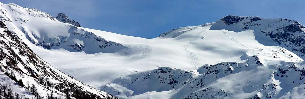
We add the description of the Via Normale that from the Bezzi Refuge near the Alpe di Vaudet (2.284m) goes up with the path n° 12A towards the Northeast reaching the Lake of San Martino or Lac St. Martin (2.770m) inside the homonymous valley. From the same, without a path but on scattered tracks, continue, crossing the Eastern most branch of the Torrent de Giasson, to the foot of the left basal moraine of the tiny San Martino Glacier, located between the Cima di San Martino (North, 3.363m) and the Truc Blanc (3.405m, in the South); go around the North-northeast and at an altitude of 3.020/30 meters around the same glacier, leaving Col de Fòs (3.294m) at the top to the East and reaching the overlying Col de Giasson (3.154m). Discarding to the left the Southeast antesummit of the Cima di San Martino (3.341m), through a small canal reach the same (EE; F; 3h'30/4h'00 hours). Turning left and heading West-northwest, follow the ridge through broken and easy rocks (some snowy bumps at the beginning of the season) and in a short time reach the Summit (3.215m; EE; F; 0h'30 hours; in total 4h'00/4h'15).
 |
 |
 |
 |
 |
Aggiungiamo la descrizione della Via Normale che dal Rifugio Bezzi presso l'Alpe di Vaudet (2.284 m) risale con il sentiero n° 12A verso Nordest raggiungendo il Lago di San Martino o Lac St. Martin (2.770 m) all'interno dell'omonimo vallone. Dallo stesso, senza sentiero ma su tracce sparse, proseguire, attraversando il ramo più Orientale del Torrent de Giasson, fino ai piedi della morena basale sinistra del minuscolo Ghiacciaio di San Martino, situato tra la Cima di San Martino (a Nord, 3.363 m) ed il Truc Blanc (3.405 m, a Meridione); contornare verso Nord-nordest ed a quota 3.020/30 metri circa il ghiacciaio medesimo, lasciando in alto ad Est il Col de Fòs (3.294 m) e raggiungere il soprastante Col de Giasson (3.154 m). Scartando a sinistra l'antecima Sudest della Cima di San Martino (3.341 m) , tramite un canalino raggiungere il medesimo (EE; F; ore 3h'30/4h'00). Volgendo a sinistra e con direzione Ovest-nordovest, seguire il crinale tramite rocce rotte e facili (qualche gobba nevosa ad inizio di stagione) ed in breve tempo raggiungere la Sommità (3.215 m; EE; F; ore 0h'30; in totale 4h'00/4h'15).
Difficulty
For Hikers or Mountainers; EE.
Per Escursionisti od Alpinisti; EE.
Equipment
For Hiking.
Da Escursionismo.Huts & Shelters
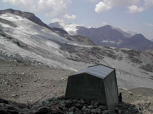
- Bivouac: bivacco Ravelli, (2.860m), 9 beds.
Campings
Remember that free camping is forbidden (except for emergency reasons, over 2.500m, from darkness until dawn).
Mountain Conditions
- You can get meteo information at the official site of the Regione Valle d'Aosta:
- Valle d'Aosta Meteo
Webcam
- WEBCAM on Aosta Valley:
- Webcam
Books and Maps
BOOKS:
- "Guida delle Alpi Occidentali", di Giovanni Bobba e Luigi Vaccarone C.A.I. Sezione di Torino Volume II (parte II), 25 Maggio 1896.
- "Guida dei Monti d'Italia–Alpi Graie Centrali" di Alessandro Giorgetta - Club Alpino Italiano/Touring Club Italiano, 1985 (in Italian).
- "Diari Alpinistici" di Osvaldo Cardellina e Indice Generale accompagnato da Schedario Relazioni Ascensioni 1964-2021 (unpublished).
- "La Valle di Rhêmes" di Lorenzo Rossi di Montelera, Ed. Tamari Bologna, Giugno 1978.
 |
 |
MAPS:
- Kompass "Gran Paradiso Valle d'Aosta Sentieri e Rifugi", Carta turistica 1:50.000.
- Studio F.M.B. "Gran Paradiso" Bologna 1:50.000.
- L'Escursionista "Valgrisenche Val di Rhêmes", Carta dei sentieri (n° 3) 1:25.000.
- Enrico Editore Ivrea-Aosta "Gruppo del Gran Paradiso" 1:50.000.
- I.G.C. Istituto Geografico Centrale Torino "Il Parco Nazionale del Gran Paradiso", 1:50.000.
Hotels in Valgrisenche
Hotels accomodations in Valgrisenche.In Bonne: Hotel Perret 11010 Valgrisenche (AO) - n° 2, LOCALITA' BONNE tel: 39.0165 97107 - fax:39. 0165 97220.
In Valgrisenche: Albergo Grande Sassiere 11010 Valgrisenche (AO) - n° 1, LOCALITA' GERBELLE tel: 39.0165 97113.
Hotel Des Mirtilles Di Putzu Fabrizio 11010 Valgrisenche (AO) - n° 7, LOCALITA' CHEZ CARRAL tel: 39.0165 97118.
Hotel Des Mirtilles Di Putzu Fabrizio 11010 Valgrisenche (AO) - n° 7, LOCALITA' CHEZ CARRAL tel: 39.0165 97118.
Important Information
- REGIONE AUTONOMA VALLE D'AOSTA the official site.
- FONDAZIONE MONTAGNA SICURA Villa Cameron, località Villard de la Palud n° 1 Courmayeur (AO) Tel: 39 0165 897602 - Fax: 39 0165 897647.
- SOCIETA' DELLE GUIDE DI VALGRISENCHE.
- A.I.NE.VA. (Associazione Interregionale Neve e Valanghe).
Useful numbers
- Protezione Civile Valdostana località Aeroporto n° 7/A Saint Christophe (Ao) Tel. 0165-238222.
- Bollettino Meteo (weather info) Tel. 0165-44113.
- Unità Operativa di Soccorso Sanitario Tel. 118.A