Overview
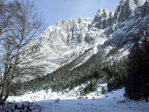
![Boljska Greda from Komarnica Canyon]() Boljska Greda from Komarnica Canyon
Boljska Greda from Komarnica Canyon![Boljska Greda from Komarnica Canyon]() From Komarnica Canyon
From Komarnica Canyon
If you approaching Dobri Do valley from Žabljak town, entering in Dobri Do you'll notice the entrance of Komarnica Canyon on the left side of the valley, below Sedlena Greda peak. That beautiful canyon is placed between two big walls of Durmitor. One of them is
Boljska Greda (2091 m), which dominate above Komarnica Canyon. Boljska Greda belong to the southern part of
DURMITOR range. Its amazing
800 m high SE rocky face is very impressive and that's a really big challenge for rock climbers. NW face of Boljska Greda stay above green Dobri Do valley, from where you can reach its summit by normal route.
![Boljska Greda]() Boljska Greda from Dobri Do
Boljska Greda from Dobri Do
Boljska Greda is beautiful from both sides, from Komarnica Canyon and from Dobri Do valley, but for sure this peak looks much more impressive when you admiring to its impressive rocky wall in Komarnica Canyon. Northern wall of Boljska Greda together with a wall of
Soa Nebeska (Bezimeni Vrh+Bobotov Kuk+Đevojka) belong to the group of most impressive walls in Durmitor. Preciselly, those two walls are most impressive and highest in Durmitor massif.
Summit View
Boljska Greda (2091 m) offer enjoyment in many beautifully panoramas. Most impressive are the view to Bobotov Kuk and view to Prutaš peak.
![Boljska greda]() Bobotov Kuk behind Boljska Greda wall
Bobotov Kuk behind Boljska Greda wall
NW: Prutaš (2393 m), Štit (2248 m)
N: Bobotov Kuk (2523 m), Bezimeni Vrh (2487 m), Đevojka (2440 m), Lučin Vrh (2396 m)
NE: Šljeme (2455 m), Sedlena Greda (2227 m)
S: Vojnik (1998 m)
SE: Moračke Planine range
Getting There
Gateway to
Durmitor National Park and
Boljska Greda (2091 m) peak is
Žabljak (1456 m) town, precisely a Poščenska Dolina valley,
Sedlo (1907 m) pass and
Dobri Do valley.
![Dobri Do valley]() Sedlena Greda & Boljska Greda from Dobri Do
Sedlena Greda & Boljska Greda from Dobri Do![Boljska Greda from Dobri Do valley]() From Dobri Do
From Dobri Do
Information how to get there:
By Plane
~To
Beograd (Belgrade, Serbia&Montenegro capital) airport. Than with plane to Podgorica, capital of Montenegro, or with bus or car to Zabljak town.
~To
Podgorica airport. Than with bus or car to Zabljak town.
Information about flights find on the sites of
JAT Airways, a former Yugoslav airlines, or on
Montenegro Airlines.
By Bus
~
Beograd (Belgrade)-
Zabljak
~
Podgorica-
Zabljak
~
Niksic-Zabljak
~
Pljevlja-Zabljak
Buses go to Zabljak from Beograd (Belgrade) twice a day and from Podgorica, Niksic, Pljevlja and Mojkovac several times per day.
![Boljska Greda from Prutaš]() Boljska Greda from the slopes of Prutaš
Boljska Greda from the slopes of Prutaš
~
Beograd (Belgrade)-
Zlatibor-Nova Varos-Prijepolje-Pljevlja-Zabljak
~
Niksic - Savnik (47km) - Zabljak (37km): 84km; Niksic to Zabljak approach from south.
~
Niksic - Savnik (35km) - Zabljak (37km): 72km;
~
Podgorica - Niksic (55 km)-Savnik (47 km)-Zabljak (37 km): 139 km; Add this length if you are going to Zabljak from Podgorica via Niksic. Road to Niksic from Podgorica is good.
~
Podgorica - Kolasin (71km) - Mojkovac (21km) - Zabljak (67km): 159km; road is good all the way to Zabljak. Behind Podgorica (56m) you go inside Moraca River canyon (one of spectacular Montenegrin canyons). It is up to 1000m deep and has wild sides. That's spectacular drive. After that, from "Djurdjevica Tara" bridge to Zabljak - 23 km.
Than from Zabljak town via Virak village in direction of
Sedlo (1907 m) pass by
Zabljak-Virak-Trsa road, 16 km from Zabljak town.
Camping
![Going to Boljska Greda]() Going to Boljska Greda
Going to Boljska Greda
Camping permitted on camping dedicated spots only. Major huts are in good condition, but with no service. Still, open to the general public. Hikers/climbers are supposed to bring all the jummy stuff with them.
The best place for camping before the climbing of Boljska Grda peak is
Dobri Do valley and its grassy plateau.
Maps & Guides
![Map of Durmitor National Park...]() Durmitor Map
Durmitor Map
Exist three maps of Durmitor:
1. Map of
Durmitor Massif & Tara Canyon - 1:25000. Author: Branislav Cerovic. You can buy it in Zabljak town in almost every store. Price: 5-6 euro.
2. Map of
Durmitor National Park & Tara Canyon - 1:25000. Author: Branislav Cerovic. You can buy it in Beograd (Belgrade, Serbia) in
Geokarta Co, Belgrade. Price: 2 euro. This map is better than first one and include many informations and facts about routes, peaks, lakes, glacial cirques, valleys, canyons,...
3.
Durmitor Mountain Guide & Map. Short mountain guide with some basic informations and facts. Author of map: Pavle S. Bandovic. Editor:
"Summit" Travel Agency, Zabljak, 2005. Price of Guide&Map: 7 euro.
Weather Conditions
The best weather forecast on Internet for
Durmitor (Zabljak town) and
Boljska Greda (2091 m) is
VREME YUBC NET site. You can see 5 days forecast for Durmitor area, 4-times-daily forecast.
Red Tape
No extra fees.

 Boljska Greda from Komarnica Canyon
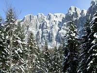 From Komarnica Canyon
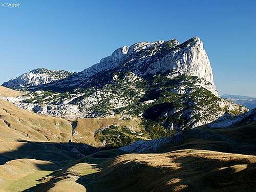 Boljska Greda from Dobri Do
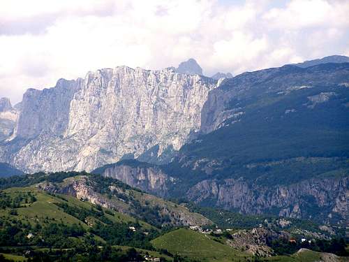 Bobotov Kuk behind Boljska Greda wall
 Sedlena Greda & Boljska Greda from Dobri Do
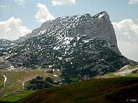 From Dobri Do
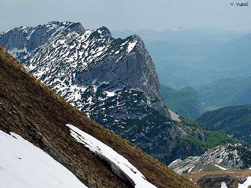 Boljska Greda from the slopes of Prutaš
 Going to Boljska Greda
  Durmitor Map