
|
|
Mountain/Rock |
|---|---|
|
|
43.13330°N / 19.10000°E |
|
|
Hiking, Mountaineering, Sport Climbing, Skiing |
|
|
Spring, Summer, Fall, Winter |
|
|
8054 ft / 2455 m |
|
|
Intro
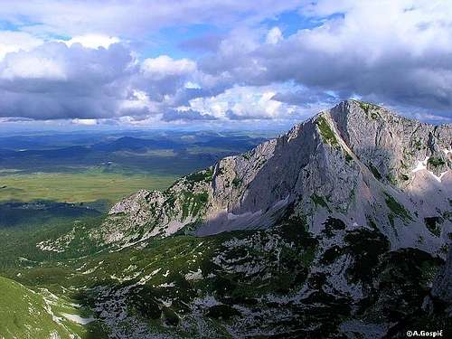
 Sljeme, Savin Kuk and Medjed from Jezerska povrs
Page you’ve opened is dedicated to the eastern corner of Durmitor, the most loved Montenegrin mountain. Here you will find information about the wildest corner north of Durmitor’s main crest, which stretches in NW-SE direction. Although central Durmitor is not a large area and is very compact, main crest divides two quite different worlds. South of the main crest, which includes the highest peak Bobotov Kuk (2522m), juicy green slopes and elegant sharp peaks prevail. This is the area of huge undulating green pastures and greenery climbs all the way to the summits and is beautifully mixed with white limestone cliffs (more about the area is on Prutas & South Durmitor page. Here, north of the main crest, story is quite different. Rock, cliffs, ridges and glacial valleys dominate the landscape while lower is green belt of beech, spruce and fir forests. Eastern part of this area is particularly interesting. From the main crest 3 parallel crests stretch towards the north, perpendicularly to the main crest. First of them or NW crest stretches between Minin Bogaz (2387m) and Cvorov Bogaz (2152m), second or middle crest is made of Terzin Bogaz (2303m) and Medjed (2287m), and third or SE crest is made of Sljeme (2455m) and Savin Kuk (2313m), two easternmost peaks of central Durmitor which descend and melt with the Jezerska Povrs (Plateau of Lakes). Between the 3 crests are two important and very beautiful glacial valleys of Durmitor, Lokvice and Kalica, as this part of the massif was heavily glaciated during the last Ice Age. Medjed, being in the center of all this, is perfect point to enjoy one of the most beautiful panoramas of Durmitor, upon its wild eastern corner.
This part of Durmitor is closest to Zabljak town, a center of the region and gateway to Durmitor, because of which this is also most easily accessible part of Durmitor.
More about Durmitor find on Bobotov Kuk and Durmitor pages.
Note: Lat/Lon given here is that of Medjed
 |  |  |  |
Medjed (2287m)
 On the ridge of Medjed (2287m), behind is Mali Medjed (2223m)
Medjed (Bear) is best known and by far most photographed peak on Durmitor massif, although most visitors probably don’t know that fact. There isn’t a single brochure about Monte Negro without its photo. As a ‘photo model’ peak it puts to shame even great Bobotov Kuk, highest peak of Durmitor. Is Medjed most beautiful peak of Durmitor? No it isn’t, but it can be contender. It is best recognized because it is closest to Zabljak town, center of the area, and beautifully decorates its background scenery but mostly because it stands above the Crno Jezero (Black Lake), largest Durmitor lake and its most popular walking promenade for all; those that aspire to climb peaks of Durmitor and those that are satisfied just be in Zabljak town and admire the beauty of Durmitor without stepping into its heart. It is this photo of Medjed, from the shore of Crno Jezero, that is photographed probably by every single visitor of Durmitor!
But Medjed is so much more than the peak that decorates Zabljak and Crno Jezero lake backgrounds. When looking from this direction one can’t even imagine what is behind this beautiful peak. That is Mali Medjed (2170m) (Little Medjed/Bear) and it acts like a screen that hides a long ridge, which contains several peaks! And this ridge is one of the most amazing walks on Durmitor and what is even better from it most beautiful panorama, north of the main crest, spreads! This very attractive and very beautiful ridge is fantastic window into the glacial past of Durmitor as you walk high above two very beautiful glacial valleys and peaks are lined up all over. Those peaks are higher than Medjed but all said makes Medjed far more appealing peak, one of three ‘a must’ visit peaks of Durmitor!
Ridge of Medjed stretches in S-N/NE direction and is almost perpendicular to main crest of Durmitor. It is almost 2km long and is not directly connected to it because between them is Terzin Bogaz (2303m) peak, which is S of Medjed. They are separated by Velika Previja (2145m) pass. Above the pass is double headed Veliki Medjed (Big Medjed/Bear), highest peak of Medjed. South Peak or Zuta Greda has 2285m while North Peak has 2287m. On the north end of the ridge is also double headed Mali Medjed (Small Medjed/Bear). South Peaks has 2223m while North peak has 2170m and that is the one visible from Crno Jezero lake. As said, ridge of Medjed is placed between two glacial valleys. On the W is Lokvice valley while on the E is Velika Kalica. Towards them ridge of Medjed descends very steeply. Side above the Lokvice valley is higher and has lot of cliffs which are mixed with dwarf pine colonies while side above Velika Kalica is mix of cliffs and steep grassy slopes. There is also some dwarf pine on the slopes. The ridge is mix of grass and rock with colonies of dwarf pine.
Whole ridge of Medjed is marked, between Velika Previja pass on the south to Mali Medjed on the north. Ridge is accessible by 5 marked paths; 2 lead from Lokvice valley and 3 from Velika Kalica.
~ Lokvice valley: from Indjini Dolovi marks lead to Mali Medjed, from Katun Lokvice marks lead to Velika Previja pass
~ Velika Kalica valley: from Struga marks lead to Mali Medjed and pass which separates Veliki from Mali Medjed, from Bivouac in Velika Kalica marks lead to Velika Previja pass.
Ridge of Medjed is quite exposed so it is not recommended to inexperienced hikers. There is lot of ups and downs with some exposed places and steeper climbing sections where use of hands is necessary. This is the reason why Medjed is not much visited despite all the mentioned superlatives. And that is another fact that’s makes it even more appealing. Two access routes to Velika Previja pass are easy but steep on places. Two routes to Mali Medjed (from Indjini Dolovi and Struga) and route to pass between Veliki and Mali Medjed from Struga are steep and slippery, especially when wet. I would say that they are even dangerous then, especially route from Indjini Dolovi!
Most beautiful way to visit Medjed is to reach Velika Previja pass either through Lokvice or Velika Kalica. From Velika Previja over Veliki Medjed reach Mali Medjed. This direction is more beautiful and there is more down than up. From the summit of Mali Medjed descent to Crno Jezero lake, either via Struga pass or Indjini Dolovi.
 |  |  |  |  |
Terzin Bogaz (2303m)
 Terzin Bogaz from Lokvice valley
Terzin Bogaz is placed between the Medjed (2287m), on the N, and highest peak of Sljeme (2455m), on the S. Together with Medjed it is a part of the long crest that is perpendicular to main crest of Durmitor which detaches from the main peak of Sljeme. But unlike the smaller peaks in the ridge of Medjed, Terzin Bogaz is massive and self standing peak. From the Medjed it is separated by Velika Previja pass (2145m) while Mala Previja pass (2200m) separates it from Sljeme. Summit ridge of Terzin Bogaz stretches from the highest point on the eastern end towards west, which is perpendicular to Terzin Bogaz – Medjed crest from which it branches. Because of this it separates Lokvice valley in two parts. Highest part is on the south and is called Ledeni Do (Ice Basin) while larger northern basin is Lokvice. Above both basins Torzin Bogaz has powerful faces but its, over 200m high, North Face above Lokvice valley is especially beautiful and striking. Routes of VI+ difficulty have been climbed in it. On the E Terzin Bogaz falls into Velika Kalica valley. Side is steep and is a mix between smaller cliffs, grass and dwarf pine.
Marks reached Terzin Bogaz from Velika Previja pass. Pass itself can be reached both from Lokvice and Velika Kalica valleys. Summit is beautiful view point but peak is not one of the popular ones because it is bit remote for the taste of most Durmitor visitors who pick more popular peaks. For those who like loneliness Terzin Bogaz is great choice.
 |
Ledeni Do – Lokvice valley
 Lake Vir u Lokvicama
Ledeni Do and Lokvice are two basins (glacial cirques) that make a large glacial valley which is placed between two S-N placed crests, which are perpendicular to main crest of Durmitor. To make it easier we can call the entire valley Lokvice, after its larger part. From the west valley is closed by Terzin Bogaz (2387m) - Cvorov Bogaz (2152m) crest while on the east is Terzin Bogaz (2303m) - Medjed (2287m) crest. Like both crests valley stretches in S-N direction and is opened towards north.
Ledeni Do (Ice/Cold Basin) makes the southern part of the valley. From all but northern side, where it is opened towards Lokvice basin, Ledeni Do is surrounded by the chain of beautiful peaks. On the W is elegant and sharp Minin Bogaz (2387m). On the S are sharp teeth Zupci (2309m), rounded Bandijerna (2409m), Milosev Tok (2426m) and western part of massive Sljeme (2455m). Between Zupci and Bandijerna is Trojni Prevoj (2245m) (Tripple Pass) over which one can cross between Ledeni Do and Surutka cirque on the southern side of Durmitor. On the E is Terzin Bogaz (2303m). Bottom of Ledeni Do is on around 2000m. Whole basin is rocky with some grass and many scattered boulders. This is wild karts area. Snow stays here long into the summer. Marks didn’t reach Ledeni Do but orientation is easy so one can easily make a crossing between Lokvice section and Surutka over the Trojni Prevoj pass from which beautiful view spreads and highest peaks of Durmitor, Bobotov Kuk, shows its sharpest side.
Lokvice makes the northern part of the valley. First let’s clear what’s in the name. Lokva means pond, lokvica is diminutive of lokva or small pond and finally lokvice is plural of the word lokvica which brings us to the end of equation so Lokvice = small ponds.
Unlike harsh Ledeni Do Lokvice is much more serene part of the valley. There is more greenery here, in form of grass, and even a small lake (or a larger pond) at the bottom of the valley. But because bottom of the valley is at around 1700m and peaks almost as high as above Ledeni Do, sides around Lokvice are higher and steeper. On the S is Ledeni Do, upper part of the valley. They are separated by the steep rocky step and passage between Terzin Bogaz (2303m) (E) and Pasovi side (W). On the N, through the narrow passage called Tijesna Brojista, which is squeezed between the cliffs of Cvorov Bogaz (2152m) (W) and Medjed (2287m) (E), Lokvice open towards the basin of Indjini Dolovi. Tijesna Brojista roughly means narrow counting spot because this narrow rocky gorge was used to count the cattle. All the mentioned peaks make impressive scenery around picturesque bottom of Lokvice. Most impressive way to meet with the beauty of Lokvice valley is to approach from Zabljak. After passing through Tijesna Brojista gorge suddenly wide Lokvice basin opens in front of you with amazing background scenery. The bottom of Lokvice is split in two parts by the small hill. North of it is Male Lokvice (Small Lokvice) while south of the hill is Velike Lokvice (Large Lokvice) with the Vir u Lokvicama (1693m) lake. On top of the hill is Lokvice Katun with few small shepherds houses. Small mountain refuge stood here but wind blew it away. Now it is popular spot to erect a tent. Shepherds still come here with their cattle during the summer. As sheep slowly graze on the juicy grassy slopes their bells gently ring providing the music of old times in this fantastic corner of Durmitor.
Lokvice is approached by marked path from Crno Jezero lake. At Lokvice Katun marks split as one path leads to Velika Previja pass (Medjed, Terzin Bogaz, Velika Kalica direction) while the other path leads towards Bobotov Kuk.
 |  |
Velika Kalica valley
If I would have to pick one corner of Durmitor which reminds me the most of rugged Alpine scenery, like that of Julian Alps for example, I would pick Velika Kalica valley. Bottom of this former glacial valley was most torn by its glacier and because of that most deprived of ever present Durmitor greenery. When you add wild limestone cliffs of Sljeme to the picture you get the right mixture of wild high Julian Alps valley.Like the nearby Lokvice valley, Velika Kalica stretches in S-N direction. On the E is Terzin Bogaz (2303m) - Medjed (2287m) crest. Their slopes are steep and are mix of cliffs, rock, grassy and dwarf pine. From the S and E valley is closed by the huge wall of Sljeme (2455m) which curves around the end of the valley and continues towards north. On the northern end of the wall is Savin Kuk (2313m). Wall is between 300-400m high. Below it are immense scree slopes. In the southern corner or end of the valley which is most squeezed between the cliffs, scree slopes below the cliffs are cover with snow whole year. This large snow field or snow slope is called Debeli Namet (Fat/Thick Drift) and is the remnant of the former glacier. Valley is only open on the N where over Struga pass (1920m) terrain begins to descent towards Crno Jezero lake.
Marked path from Crno Jezero lake leads through Velika Kalica valley. From it, on the Struga pass, which makes the beginning of the valley, marked path towards Mali Medjed branches. At the end of the valley is, on a small head by the Debeli Namet snow field, tiny red square stands which is visible from distance. That is Bivak refuge (2020m) (bivouac). From it the only way left for marks is out of the valley and they lead to Velika Previja pass. From the pass marks go left to Terzin Bogaz (2303m), right to Medjed (2287m) or straight into the Lokvice valley.
 |  |  |
Savin Kuk (2313m)
 Western side of Savin Kuk (2313m) above Velika Kalica valley, seen from Medjed (2287m)
Savin Kuk is one of the most recognized, most photographed and most visited peaks on Durmitor! In the famed Crno Jezero panorama Medjed takes most acclaims but Savin Kuk is that beautiful triangle shaped peak on the left and without it Medjed and whole of panorama wouldn’t be as beautiful. Savin Kuk is even more beautiful and more impressive from Zabljak because from here its beautiful triangle north face is fully revealed. It is one of most visited peaks because of the chair lift that climbs high up its eastern slopes and stops only hundred meters below the summit. Chair lift is part of Durmitor ski center which to some degree ruined the unspoiled beauty of the eastern side of Savin Kuk. But if something had to be sacrificed on Durmitor by the fancy beauties of civilization Savin Kuk wasn’t a bad choice because it is on the eastern edge of Durmitor and not in its heart.
As just mentioned Savin Kuk, together with mighty Sljeme (2455m), makes eastern edge of central Durmitor area. Savin Kuk is large peak. E is highest. It rises some 800m above the Jezerska Povrs (Plateau of Lakes). Side is mostly grassy but has some rock and smaller cliffs sections. It is called Cista Strana (Clean Side). At the foot of the side is narrow belt of beech forest. Chair lift is on this side. On the S is might and bulky Sljeme (2455m), largest peak on Durmitor or better to say mountain within a mountain. From it Savin Kuk is separated by narrow and steeply rising scree valley called Korita. In winter here is ski track. On top of it is pass which separates the summit of Savin Kuk from Sljeme. On the W it falls with few hundred meters high West Face into the northern part of Velika Kalica valley. N is most beautiful and most impressive. Triangle shaped North Face, which is 500m high, falls into the basin of Mala Kalica.
South of the summit dome, near the top of the chair lift, is famous spring Savina Voda (Sava’s water). It was believed that spring has healing powers so it was annually visited in procession on August 2nd (Ilinden). At the beginning of the last century track was build to the very summit which enabled Montenegrin ruler to easily reach the summit. Because of the build track and chair lift Savin Kuk is second most visited peak on Durmitor, behind highest Bobotov Kuk. Marked path leads to the summit from Crno Jezero lake. From the pass between the summit and Sljeme, it is possible to descent to Velika Kalica but this is not marked and is only for experienced hikers. Also from the pass marked path leads to Sljeme but this is also only for experienced hikers because it leads steeply through the cliffs (Osojna Greda face).
 |  |  |
Sljeme (2455m)
Sljeme is largest peak of Durmitor or more correctly a mountain within mountain which contains many smaller peaks on its broad crest. Sljeme and Savin Kuk (2313m), which is N of it, make eastern edge of central Durmitor, above the Jezerska Povrs (Plateau of Lakes). Sljeme is also third highest peak of Durmitor, behind Bobotov Kuk (2522m) and Bezimeni Vrh (2487m).Crest of Sljeme stretches in gentle arc from the Milosev Tok (2426m), which is on the western edge, to the pass which separates it from Savin Kuk, on the north. Southern and eastern slopes are huge. Towards S they descent into Poscenska Dolina valley while E slopes descent towards Jezerska Povrs, some 900m! Although they have different orientation this is basically one compact side. It is mix of long grassy slopes which are interrupted with cliff jumps and scree valleys or small scree basins, former glacial cirques. Northern and eastern side of the Sljeme is different story. It is not as high and falls perpendicularly with long North and Eastern Face, which stretches in gentle arc, into the Ledeni Do basin (N) and Velika Kalica valley (W). Face is few kilometers long and around 400m high. Below it are immense scree slopes. On the north end Sljeme is separated from Savin Kuk by narrow pass in the highest part and by the Korita valley which is squeezed between them. Sljeme falls into Korita with powerful Osojna Greda face.
Crest of Sljeme is broad and quite flat, covered with juicy grass. Average altitude of around 2km long crest is around 2400m which makes it highest part of Durmitor in terms of area size above 2400m. Above it small peaks rise. Highest peak has 2455m and behind it is Eastern Summit with 2445m.
Marks lead along the whole crest of Sljeme. Path branches from the Crno Jezero Lake – Savin Kuk route. It leads up the grassy Cista Strana (Clean Side, eastern slopes) till the Eastern Summit of Sljeme and then over the Main Summit, along the edge of the face, all the way till the western end and Milosev Tok (2426m). Approach to Sljeme is possible directly from Savin Kuk summit but this is quite demanding climbing section till the ridge of Sljeme. Because of this Sljeme is not visited by many.
 |
Jezerska Povrs / Plateau of Lakes
Jezerska Povrs or Plateau of Lakes is huge undulating high grassy plateau, placed between 1400 and 1500m, between the Durmitor, on the west, and Sinjajevina, on the east. But in hearts and minds of people it belongs to Durmitor.If you like such high open spaces this is dreamland. Words can hardly describe how beautiful and romantic is Jezerska Povrs. From its gentle green waves beautiful views spread towards southern and eastern edges of central Durmitor area. Especially beautiful is part at the eastern foot of Durmitor where many small houses are scattered on the green hills. Some are still old wooden shepherds houses but mostly they are newer concrete house. What is good is that they are small, not large leisure villas, so they didn’t ruin the beauty of the area but on the contrary, it looks beautiful. Such hamlets are Moticki Gaj, Virak and Poscenski Kraj, to name the few. Through centuries people have lived here with their cattle, which was main resource. Today people are turning more and more to tourism, although old way of life is still present and adds to the romantics of the area. Largest settlement on Jezerska Povrs is Zabljak, which has grown from village to small town and tourist centre of the region. Zabljak is highest placed town on the Balkan (read more about it on the Bobotov Kuk page).
Lakes on Jezerska Povrs have glacial origin. There aren’t too many of them and they are placed in the depressions between the hills of the plateau. These lakes are no big but add even more to the beauty of the area. Best known are Poscensko Jezero (named after the hamlet), Vrazje Jezero (Devils Lake) and Riblje Jezero (Fish lake). On the plateau there is also lot of creeks and water sources.
 |  |  |  |
Routes Overview
Medjed (2287m)~ Crno Jezero Lake (1416m) – Struga pass (1920m) – Velika Kalica valley – Bivak refuge (2020m) – Velika Previja pass (2145m): 2:45h
~ Crno Jezero Lake (1416m) – Struga pass (1920m) – Mali Medjed (2223m): 2:10h
~ Crno Jezero Lake (1416m) – Indjini Dolovi – Katun Lokvice (1700m) – Velika Previja pass (2145m): 2:50h
~ Crno Jezero Lake (1416m) – Indjini Dolovi – Mali Medjed (2223m): 2:35h
~ Velika Previja (2145m) – Veliki Medjed (2287m) – Mali Medjed (2223m): 1:45h
Terzin Bogaz (2303m)
~ Crno Jezero Lake (1416m) – Struga pass (1920m) – Velika Kalica valley – Bivak refuge (2020m) – Velika Previja pass (2145m): 2:45h
~ Crno Jezero Lake (1416m) – Indjini Dolovi – Katun Lokvice (1700m) – Velika Previja pass (2145m): 2:50h
~ Velika Previja (2145m) – Terzin Bogaz (2303m): 30min
Lokvice valley
~ Crno Jezero Lake (1416m) – Indjini Dolovi – Katun Lokvice (1700m): 1:50h
~ Katun Lokvice (1700m) – Ledeni Do – Trojni Prevoj (2245m): 1:40h
Velika Kalica valley
~ Crno Jezero Lake (1416m) – Struga pass (1920m) – Velika Kalica valley – Bivak refuge (2020m): 2:15h
Savin Kuk (2313m)
~ Crno Jezero Lake (1416m) – Mioc Poljana (1569m) – Korita – Savina Voda spring (2212m) – Savin Kuk (2313m): 3h
Sljeme (2455m)
~ Crno Jezero Lake (1416m) – Mioc Poljana (1569m) – Panalj (1813m) – Cista Strana – Sljeme (2455m): 4h
~ Savin Kuk (2313m) – Zdrijelo couloir – Sljeme (east summit 2445): 45min
Getting There
Gateway to Durmitor is Zabljak town. Here is information how to get there.By Plane
Air gateway to Monte Negro is capital Podgorica. Information about flights find on the sites of Serbian JAT Airways, a former Yugoslav airlines, or on Montenegrin Montenegro Airlines. Once in Podgorica by plane you’ll have to take a bus or rent a car.
By Bus
Buses go to Zabljak from Podgorica, Niksic, Pljevlja and Mojkovac several times per day.
By Car
Niksic – Savnik (47km) – Zabljak (37km): 84km –> before tunnel on Vojnik mountain was opened this was normal Niksic to Zabljak approach from south. It is beautiful but hard to drive mountain approach as road is slow and narrow with two major ascents. First it ascends from Niksic (649m) to Krnovo pass (1487m). Behind is steep descent to Savnik (824m) town and then long ascent via bad and narrow road to Zabljak (1450m).
Niksic – Savnik (35km) – Zabljak (37km): 72km -> since road and tunnel on Vojnik mountain, which connects Niksic – Piva river road with Savnik town, was opened this is normal Savnik and Zabljak approach from Niksic (649m) as one avoids Krnovo pass. Head towards Piva River. 17km’s behind Niksic, at Jasenovo Polje, turn right towards Savnik. Road ascends up the Vojnik mountain till 1500m where is short tunnel below the main crest. Behind is steep descent to Savnik (824m). From Savnik bad and narrow mountain road leads to Zabljak.
Podgorica – Niksic: 55km –> Add this length if you are going to Zabljak from Podgorica via Niksic. Road to Niksic from Podgorica is good.
Podgorica – Kolasin (71km) – Mojkovac (21km) – Zabljak (67km): 159km -> road is good all the way to Zabljak. Behind Podgorica (56m) you gradually go inside Moraca River canyon which gradually turns ever more spectacular. Canyon of Moraca is one of spectacular Montenegrin canyons. It is up to 1000m deep and has wild sides. After exiting the canyon there is short section of wider valley, by the road is famous Moraca monastery. Soon long and steep ascent over Crkvine pass (1045m) begins. From it is amazing view towards beautiful and wild surrounding mountains and from top into the Moraca River valley. Behind Crkvine pass there is short descent to Kolasin town. By the Tara River road continues to Mojkovac town. Till here you are on main Montenegrin road which connects Podgorica with Serbia so expect traffic, especially during summer. From Mojkovac you leave the main road by going left towards Zabljak. Road follows Tara River and after some 12km through wide valley Tara enters its spectacular canyon which is 1000m deep on this section. After 32km you are at legendary bridge on Djurdjevica Tara. From the bridge road ascends in many bends out of Tara’s canyon and after 23km you are in Zabljak. Once on Jezerska Povrs plateau peaks of Durmitor enter the view, they act magnetically. This is amazing drive all the way.
Maps
On Zabljak you can buy very good maps of Durmitor (1:25000 scales) in almost every store.

When to Climb
Durmitor is typical summer hiking mountain. From October to June it is under snow whose depth grows towards spring to few meters. Then very few visit central part of Durmitor. Of course, as any mountain Durmitor can be climbed during whole year including mid winter, but in Monte Negro such activity is not yet well developed so it is quite unlike that you will meet someone, except at the edge of central part where people ski, like on Savin Kuk. Full winter equipment is necessary; don’t need to say what that includes. Temps can drop to -30°C! Large open slopes of central part, which are under deep snow that covers even large boulders making them smooth, must be paradise for extreme and tour skiers in amazing scenery. During short summer temperatures are pleasant which means it is not hot to die and it is not that cold to be in long sleeves and trousers. Anyway as soon as clouds cover the Sun and there is little bit of wind warm clothes is necessary so always have a jacket in backpack. Snow is possible even in mid summer.Mountain Conditions
Weather forecast and conditions can be found for Zabljak at Accuweather site.On WeatherOnline there is no Zabljak but you can find forecast for various Monte Negro towns. Of them Pljevlja is closest to Zabljak (some 30km to the north).