
-
 28935 Hits
-
 93.46% Score
-
 43 Votes
|
|
Area/Range |
|---|---|
|
|
36.15434°N / 115.43264°W |
|
|
Hiking, Trad Climbing, Sport Climbing, Bouldering, Scrambling |
|
|
Spring, Summer, Fall, Winter |
|
|
4925 ft / 1501 m |
|
|
Overview
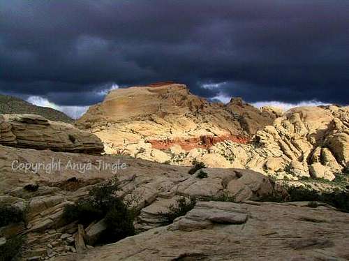
Less than an hour from the glitter and decadence of the Vegas Strip (less than half an hour if all the stoplights did not exist) is a sandstone paradise painted in colors that are striking no matter the time of day and which is accessible by as little as a one-minute walk from the car. This sandstone paradise is called the Calico Hills, and it is part of the wider and justly popular Red Rock Canyon National Conservation Area.
Whether you are a hiker, a scrambler, a wanderer, or a rock climber, there is something here for you amid these red and yellow peaks.
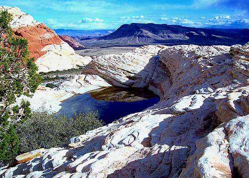
One of the most delightful things about the Calico Hills, maybe the most delightful thing from an aesthetic standpoint, is the abundance of tanks, or tinajas, found there. These depressions, sometimes quite wide and deep, hold water for much of the year, even sometimes during the summer months (though I have seen them dry in summer as well), and are a critical lifeblood for area wildlife and ecosystems unto themselves. (Don't go into them or use them for bathroom breaks!) Only one trail leads to a tank (a moderate hike of about 3 RT miles gets you to a large one in a spectacular setting), but I have come across well more than a dozen hidden among the peaks, and I don't doubt there are more. In fact, there is one just below the summit block of the range highpoint, helping make an outing to that peak one of the most worthwhile ones in the entire Red Rocks area.
Due to several factors, the Calico Hills are a good year-round destination. In the winter, the canyon approaches to the higher peaks in RRCNCA can be icy and the summits can be quite cold, but that is not as much of an issue in the Calico Hills. During the summer, heat makes hiking and climbing in the region anywhere from unpleasant to perilous, but because the peaks of the Calico Hills have short approaches and are relatively low, one can climb them (or do technical climbs on the walls of the western side) early in the morning, beating the heat and sometimes even beating the sun itself.
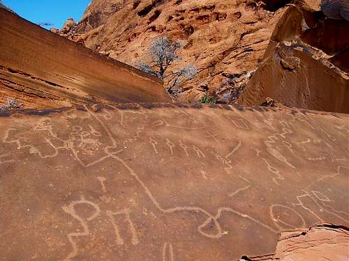 Native American Petroglyphs in the Calico Hills area
 Spotted near the Calico Hills
Boundaries and Sections
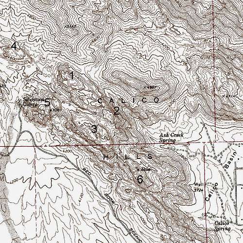
Defining the boundaries of the Calico Hills produces different interpretations. Most seem to see them as the sandstone peaks running northwest-southeast roughly parallel to the Scenic Loop Road between the entrance and Sandstone Quarry. Others, however, include New Peak and Kraft Mountain (Points 4987 and 4714 on the map below), and some even include nearby Turtlehead Peak, partially visible on the map as the formation northwest of Point 4987. However, those are all limestone peaks (though New Peak does have quite a bit of sandstone as well, a crossover peak of sorts), and they are separated from the sandstone peaks by significant saddles or drainages. For purposes of this page, I am going with the definition most seem to use, which makes 4925' Red Cap the highpoint of this small range.
By rpc-- The Calico Hills are a complex (though relatively short), beautifully colored group of sandstone formations just north of the entrance to the Scenic Loop Road. Most climbers who visit the Calico Hills are not there to "bag a summit" but rather to enjoy the nearly countless single-pitch routes on the numerous walls (a mix of trad and sport routes) as well as a few two-pitch routes. Urioste's guidebook logically divides the Calico Hills into three areas: Sandstone Quarry (on the northwest edge of the hills), the Southwest Side (runs parallel to the Scenic Loop Road and is overrun with tourists), and Calico Basin. Descriptions on how to reach the individual areas are given in Getting There.
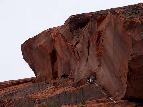 Working up Pitch 1 of The Great Red Book
Peaks of the Calico Hills
Although there are no officially named peaks here, there are at least two unofficially named ones and several more distinct summits. In addition, there are numerous outcrops and minor summits to explore. Many of these are at least Class 3, and some are Class 5.
Following is a series of photos of some of these peaks. If the peak has an SP page, then the name in the caption works as a link to the page. Included as well is a mention of the difficulty of the peak by its easiest way up.
The peaks are arranged in descending order by elevation.
 Red Cap (4925')-- Class 4. Shortest and easiest approach from Sandstone Quarry but often approached from Calico Basin by locals.
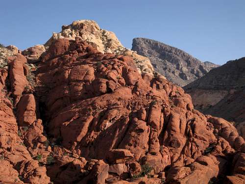 Calico Tank Peak (4870')-- Class 3. Easiest approach is via Calico Tanks Trail from Sandstone Quarry.
 Point 4850, or what I call West Calico Tank Peak-- Class 3. Good approaches from Sandstone Quarry and Second Overlook.
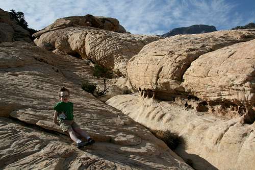 Unnamed, unmarked (about 4760')-- Class 4. I nicknamed this one "Tinaja Peak" because of all the tanks I found on it. Accessed from Sandstone Quarry.
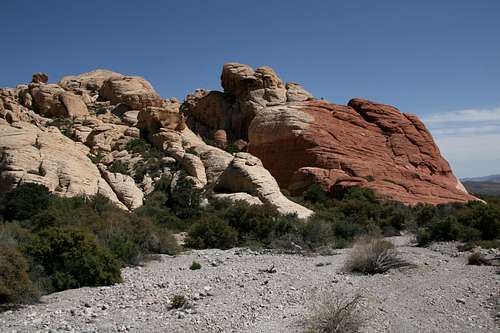 Point 4708 (left)-- Class 4. The peak on the right is unmarked (elevation-wise) on maps and requires a little Class 5 and some pretty respectable exposure to summit. Accessed from Sandstone Quarry.
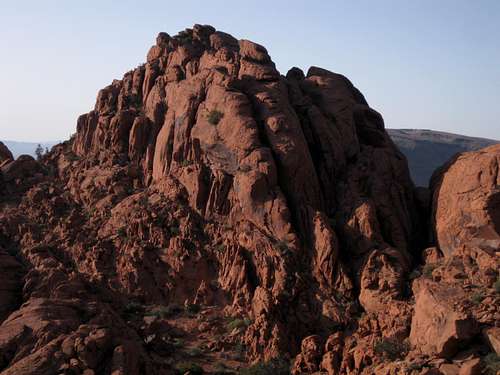 Point 4608-- Class 4. Access from First or Second Overlook.
Technical Climbing
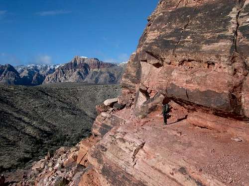
There are single-pitch trad and sport routes galore here, and some two-pitch routes as well. Because of the easy access and year-round favorable conditions (can be quite warm here on winter afternoons), this is a super-popular area with climbers.
Attached to this page are several mountain/rock and route pages for walls and other formations here.
Getting There
From Charleston Boulevard (Route 159) west of I-215 and Summerlin, drive west past the end of the development (it occurs rather suddenly).To get to Calico Basin, turn onto the signed road to Calico Basin; this road is about one mile east of the entrance to the Scenic Drive in RRCNCA. Keep right when you reach the spur to Red Springs Picnic Area (or go into Red Springs and park) and soon bear left onto Sandstone Drive. Follow that road to its end; there is a large and obvious parking area on the left. The distance from 159 to the parking area is about two miles. For the Southwest Side and Sandstone Quarry areas, turn onto the Scenic Drive in RRCNCA. Just before Mile 3, you reach the signed Sandstone Quarry area (it is the third developed pullout along the road); turn off and park here. The first two developed pulloffs are the Calico Hills overlooks and are the access points for the Southwest Side. Entrance fee of $15 per vehicle (2018). Annual and interagency passes are available (the Interagency Pass, AKA the America the Beautiful Pass, grants access to all federal fee areas for a year).
 Killing time at the Moderate Mecca
Unfortunately and also unsurprisingly given the explosion in visitation at RR over the past several years, there is so much red tape that I can't list it all and can't keep up with it since it keeps changing.
The daily fees keep going up. During certain periods of the year, you need a reservation to get in on the Scenic Loop. You can't go in early before the gates open, but you'll get ticketed and fined if you're not out by closing time. Late-exit permits are available, but they don't cover you overnight. And it looks as though Calico Basin is going to get a reservation and/or fee system, with gates.
For accurate current information, it's best to check the RRCNCA website.
When To Climb
As is true for all climbing in Red Rocks, the question of "when to climb" (or, more specifically, "when to climb comfortably") varies from route to route out here. "When NOT to climb" is easier to answer: DO NOT climb after rain. Give the rock at least 24 hours (or more depending on duration/intensity of the rain) to dry out following a rainy period. According to Swain's guidebook, sandstone becomes more brittle when wet.Camping
There are no campgrounds off the Scenic Drive in RRCNCA. There is a campground outside it, though; see here for more details. Bivouacs and backcountry camping are permitted, but with permits and restrictions; however, I do not think backcountry is legal in the Calico Hills at all. Use the link at the end of this page to find out more.Mountain Conditions
BLM Red Rock Canyon National Conservation Area HCR 33, Box 5500 Las Vegas, Nevada, 89124 Phone: (702) 363-1921 Climbing Rangers at Red Rocks (very nice and helpful): 702-515-5138 or 702-515-5042Guidebooks
Most people today seem to use what everyone calls the Handren guide-- Red Rocks A Climber's Guide by Jerry Handren.
By rpc--
The Falcon guide to the area, Rock Climbing Red Rocks by Swain, is an excellent resource. Contains some pictures of routes, nice approach maps, and great topos of some of the more popular routes. Swain, however, does mention the fact that he has not climbed any of the routes listed for Mt. Wilson, for example. No topos and no photos are given for Physical Graffiti, for example (you don't really need them anyway). An out-of-print guidebook (the little red book) by one of the Red Rocks climbing pioneers, Joann Urioste, can also be found (try Amazon.com). Urioste mistakenly calls Physical Graffiti a 5.9 route. There are no route topos in her guidebook, but she does provide some route overview photographs for select routes (incl. Physical Graffiti).
Even though some overlap exists between the two guidebooks, each DOES contain some unique material. For those planning on doing the less popular routes at Red Rocks, Urioste's book is definitely worth having.