
-
 18069 Hits
-
 85.87% Score
-
 21 Votes
|
|
Mountain/Rock |
|---|---|
|
|
36.16204°N / 115.43749°W |
|
|
Scrambling |
|
|
Spring, Fall, Winter |
|
|
4870 ft / 1484 m |
|
|
Overview
It doesn't take long for a first-time visitor to realize that the colorful Calico Hills, while being extremely popular with sport and trad climbers, are also a scrambler's wonderland. Several summits only attainable by Class 3 or harder scrambling are out there, and there are seemingly countless smaller formations and outcrops to play on.As far as I can tell, Calico Tank Peak (unofficial name written on the summit register I found there) is the second-highest peak of the Calico Hills. It rises directly above and east of the tinaja reached by the popular, moderately difficult, and highly scenic Calico Tanks Trail.
Finding the summit and register was an accident of sorts for me. With my oldest child, I had hiked to the end of the trail, and we had scrambled about on all sorts of rock outcrops while waiting for my mother, my wife, and my other two kids to catch up. Once they did, I rambled off alone and, as often has been the case, ended up atop a summit I hadn't even thought about just an hour before.
The route I found up the peak seemed to be the best one from trail's end; there was another I scouted from the trail during the return hike, and a picture in this page's gallery documents that proposed route. There may be other non-technical routes as well.
Views are awesome, and solitude is likely. Entries in the register suggested that even in the prime seasons of spring and fall in the Calico Hills, the average number of people or parties climbing the peak per day is less than one.
 |  |  |
Getting There and Route Information
Trailhead Directions
From the entrance to the Scenic Drive in Red Rock Canyon National Conservation Area off SR 159, drive about three miles to the signed parking area for Sandstone Quarry. On a nice spring or fall day, even a weekday, expect to have to hunt for a parking spot if you show up later than 10 A.M.
The bummer about this is that the road is one-way only. If it's your first time to Red Rock Canyon, it's not so bad having to drive the often-slow full loop (almost 13 miles). But if you've been there and done that, you might consider parking at the visitor center and then getting on your bike to ride to the trailhead. That way, you can ride back (against traffic) and save yourself some time and some gasoline (translation: money).
Some people park along the shoulder or at a pullout along SR 159 and bike in. You still have to pay the entrance fee, but I believe it is less than the fee for motor vehicles.
Some people approach the Calico Hills from Calico Basin, and there is indeed a route to Calico Tank Peak from there via Ash Canyon (Class 4).
Climbing Route from Sandstone Quarry
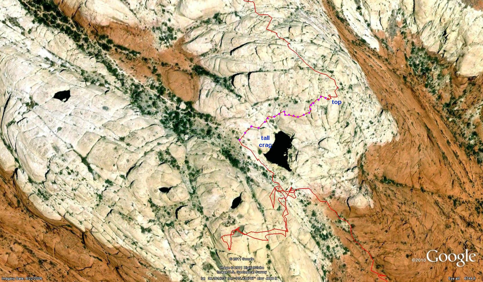
Hike the moderately difficult 1.5-mile Calico Tanks Trail to the overlook of the large tinaja and then to a saddle providing a view of Calico Basin and Las Vegas. From there, head east along slopes and ramps until you reach a cliffy overlook of the vicinity.
 Route photos... Route photos... |  |  |
From there, climb up (two Class 3/4 options immediately present themselves, and there are pictures of both above) and scramble along the path of least resistance (or harder if you wish) until you reach the summit. Not far below the summit is a much smaller tinaja than the one that is the namesake of the nearby trail.
 |  |
Overall distance to the summit from the trailhead is about two miles, with approximately 1000' of elevation gain.
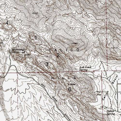
Calico Tank Peak is peak #2 here.
Class 2+ Alternative
From MoapaPk: "If you stop just west of the big tank (before the big crag on the W side) and go to the top from there, it's easier."
Google Earth map and diagram
From Second Overlook
This way is more direct but a bit harder. Park at the second Calico Hills overlook (about 2 miles from the gate) and drop into the wash below. Scramble your way (expect Class 4) to the saddle between Calico Tank Peak and "West Calico Tank Peak (Peak #3 on the map above) and then follow the first route described above.
Red Tape, Camping, Links
There is a daily entrance fee of $7 per vehicle (2013). Annual and interagency passes are available (the Interagency Pass, AKA the America the Beautiful Pass, grants access to all federal fee areas for a year).
Hours the Scenic Drive is open:13-Mile Scenic Drive
Note: these hours are subject to change. To be safe and sure, contact the park before visiting.
Hours the Scenic Drive is open:13-Mile Scenic Drive
| November through February | 6 a.m. to 5 p.m. |
| March | 6 a.m. to 7 p.m. |
| April through September | 6 a.m. to 8 p.m. |
| October | 6 a.m. to 7 p.m. |
Note: these hours are subject to change. To be safe and sure, contact the park before visiting.
The BLM (the agency that manages this area) allows dogs in the backcountry. Please keep them leashed and pick up their feces.
There is no entrance fee in Calico Basin.
The Calico Hills get brutally, dangerously hot in the summer. Climbing there then is not a good idea unless you go at night, which has its own risks, or very early in the morning and finish before late morning.
Red Rock Campground is off SR 159 a few miles from the visitor center. Please see here for details. Backcountry camping in RRNCA is only allowed above 5000', so it is illegal in the Calico Hills.
RRNCA Site