
|
|
Mountain/Rock |
|---|---|
|
|
45.33117°N / 116.46873°W |
|
|
Idaho |
|
|
Hiking |
|
|
Spring, Summer, Fall |
|
|
7197 ft / 2194 m |
|
|
Overview
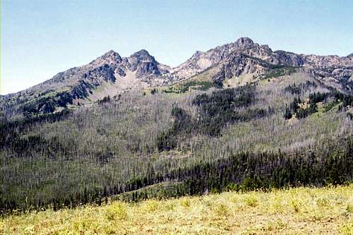 The best thing about Cannon Ball Mountain would be views of the Seven Devils.
 Losing light
 The summit
 Coconut Grove
 South slope
Cannon Ball Mountain is found directly east of the highest summits of the Seven Devils Mountains of Idaho. At 7, 197 feet it is the largest and highest of the Seven Devils foothills or it is the smallest mountain of the main range. It connects to the main Seven Devils divide at the south end of the Heaven’s Gate ridge by a saddle giving it a prominence of 657 feet. The summit is broad and rounded, but it falls off steeply in every direction including a nearly 4,000 foot drop south into the West Fork of the Rapid River and approximately 4,800 feet to the main fork of the Rapid River to the east. The Bridge Creek basin, which separates the mountain from the main Seven Devils peaks, is a 1,400 to 3,000 foot drop from the summit of Cannon Ball. There are several interesting features about this mountain. The warm canyon grasslands that dominate the lower elevations throughout the Salmon Basin merge directly into the higher montane grasslands and subalpine parklands with no intervening forest between. This is may be the only significant place where this unusual ecological situation is found. Also the extensive onion grass community on steep gravel on part of the south slope is unique. The summit area supports a few widely scattered lodgepole pine and Douglas fir with a few white bark pine, while the east side supports old growth Douglas fir, lodgepole pine and subalpine fir. Large forest fires in the 1990s burned much of the area of the Seven Devils and extended east over the summit of Cannon Ball leaving a few acres of standing dead forest. The Douglas fir forest is experiencing high mortality and contributing to heavy fuel loads setting up for another large fire in the area. There are several significant springs popping out of the mountain, especially on the south side. Substantial subterranean moisture contributes to the unusual feature known as Coconut Grove. This small two or three acre patch of large, old fir trees rises on a south side bench at about 5,500 feet. Unfortunately the shade provided by this grove in close proximity to forage and water has been highly desirable to livestock that have turned the area into a barnyard. Other areas of the mountain have been grazed often excessively especially near the tree lines or small pockets of trees. The once lush native grasslands of some of the more gentle terrain where livestock congregate most have been transformed into acres of weeds. The over grazing has not been good for the ecology, wildlife or even the cows. The views to the north and east are mostly blocked by heavy forests on those aspects. But the views from the southeast around to the west are amazing due to the position of the mountain between the deep Little Salmon Canyon and the high Seven Devils. The elevational range between the two exceeds 7,400 feet near the mouth of the Rapid River Canyon, which drains the slopes of Cannon Ball and the higher Devils. Further to the southeast beyond the Little Salmon Canyon, the higher peaks of the Grassy Mountains rise nearly 7,000 feet above the main canyon. Cannon Ball is set at a position ideal for taking all this in.
Getting There
 Looking down into Rapid River
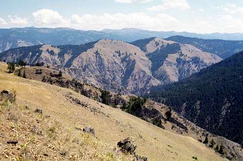
 Above Scott Saddle
 Scott Saddle
 Nearing the top
Take Highway 95 to Riggins, which is 153 miles north of Boise or 118 miles south of Lewiston, Idaho. Just outside the south edge of Riggins, look for a large brown recreational sign for the Seven Devils and Heavens Gate. This will be Forest Service road 517. Turn west on this road and follow it about 9.2 miles to the 2109 road. This road is on a hairpin curve and may be gated from mid-fall to early summer. Continue of this road for about 6.9 miles to Saddle Camp at the road’s end. There will be a corral and some good dispersed camping spots here, but not much else. There is a good chance cows could be hanging out here as well. Between the 517 road and Saddle Camp just stay on what appears to be the main road. There are a couple junctions where this may not seem clear, but if in doubt just stay to the right. From Saddle Camp head a short distance on a trail to the main ridgeline and hike to the summit. It is just under a mile and to the summit with about 700 feet in elevation gain. Another option is to pass the 2109 road and continue up the 517 road to where it crosses over the southeast flank of the Heavens Gate mass. This obvious aspect change is about 15 miles up from Highway 95 or about one mile east of the Windy Saddle Campground. There is plenty of parking with a spectacular view of the Tower Of Babel to the southwest. From here hike down the ridge for a 880 foot drop over a mile to Scott Saddle and proceed as above. A much more difficult option is to climb the mountain from the Rapid River Canyon. About four miles south of Riggins, turn off Highway 95 to the west on the Rapid River Road (road 2114) and continue for less than three miles to the Rapid River Fish Hatchery and the trailhead. Hike the trail up the Rapid River for less than a mile to a fork in the trail. Take the right fork and hike up Thorn Gulch, then over the ridge to Blue Gulch. The trail then climbs the south ridge, which is the main east ridge of Cannon Ball Mountain. This trail rises 5,000 feet over approximately six miles. Parts of it are very faint or even missing so be prepared for some difficult hiking in some very rugged terrain. Maps show another trail connecting from lower Shingle Creek (just north of the fish hatchery) to Scott Saddle, but no information is given here for that trail should it exist.
Red Tape
None, but much of the adjacent areas are designated wilderness so be aware of where the boundaries are.
Camping
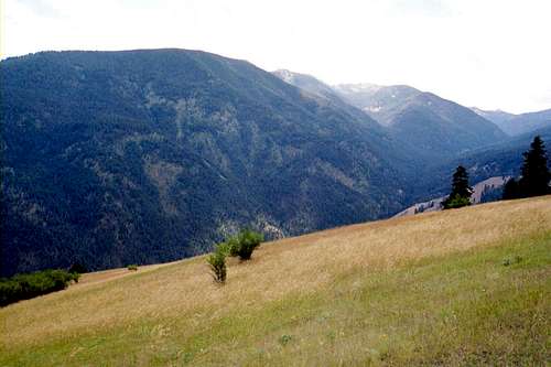 West Fork Rapid River
A good dispersed site is at Scott Saddle near the start of the hike. But there could be stockmen here and plenty of cow pies (or even the cows) to contend with. The only campgrounds in the area are near the end of the 517 road on or near Heavens Gate. Windy Saddle Campground is about 16 miles up the 517 road and Seven Devils Campground is about a mile beyond that on the spur road toward the main mountains. The Forest Service visitor map shows a small campground, Papoose, about five miles up the 517 road just inside the National Forest boundary. This really is just a worn dispersed side in the bottom of Papoose Creek. Backpackers can hike into the Rapid River basin and hike up the mountain from below, but there is really no reason to do this unless that’s the experience someone is looking for.
When To Climb
 Aspen
AspenThe best time to do this hike is during mid to late summer. Snow will prevent accessing the area in the spring or early summer, especially if coming in from Heavens Gate. The mountain can also be hiked in winter, but the access can be difficult and while the lower elevations may be clear of snow, the upper slopes may have heavy snow. A good winter hike could be the attempt from the Rapid River bottoms as they rarely have snow. But it’s doubtful one would have time in the shortened days to get to the top without some snow shoeing and returning in the dark. Thunderstorms can occur in the summer and the temperatures between the hot Salmon Canyon and Seven Devils can vary dramatically so be prepared for more than one season. Fall would be a good time, but hunters can be numerous, especially on weekends. Wear orange if going to the mountain during that season.
Mountain Conditions and Additional Information
 From The Ogre
Contact the Salmon River Ranger District of the Nez Perce National Forest for local information and current conditions. The higher Seven Devils Mountains and recreational areas nearby are managed by the Wallowa Whitman National Forest out of the Hells Canyon National Recreation Area office on the south end of Riggins. Nez Perce National Forest 104 Airport Road Grangeville, ID 83530 208-983-1950 Salmon River Ranger District Slate Creek Ranger Station HC 01, Box 70 Whitebird, ID 83554 (208)839-2211 FAX:(208)839-2730 Hells Canyon NRA Riggins Field office 189 Highway 95 Riggins, Idaho 83549 (208) 628-3916 NOAA Forcast
Other Neat Stuff
The areas in close proximity around Cannon Ball Mountain provide an unusual variety of things to do. A short list of some of the more interesting local activities follows. Heavens Gate
 Heavens Gate
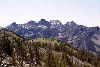 Seven Devils
 Salmon Canyons
 Hells Canyon
 Caves
CavesThe summit of Heavens Gate provides stunning views of the rugged Seven Devils Mountains as well as views into deep Hells Canyon and the Salmon River Canyon, two of the deeper canyons in North America. The mountains of the expansive Clearwater and Salmon River ranges fill the horizon and beyond from north to south. Particularly impressive are the 6,000 to 7,000 foot drops from the Southwest Butte and Patrick Butte to the northeast and southeast of Riggins respectively. Under ideal conditions it is possible to see all the way to the high Bitterroots just inside the Montana border, making four states visible. To the southwest the magnificent Wallowa Mountains of Oregon dominate the horizon and the Camas and Palouse prairies lay to the north and northwest in Idaho and Washington. The Seven Devils The Seven Devils Mountains form the highest section of the divide between the Snake and Salmon Canyons. These mountains rise about 8,000 feet above the Snake in Hells Canyon and nearly as much over parts of the Salmon to the east. There are over 70 mountain lakes, may with excellent fishing and many miles of trails accessing these rugged peaks. The Heavens Gate/Windy Saddle area next to Cannon Ball Mountain is the main access point. Rivers The Snake and Salmon Rivers provide world class whitewater. Trips can range from multiple day affairs through remote wilderness canyons to half day; load the family in a boat by the highway type trips. Some of the best rapids on the entire Salmon River are found along Highway 95 just north of Riggins. There are many guide companies in Riggins and with most you can get on a boat without an appointment if you arrive at the suitable time. It’s best to call ahead, especially on warm weekend days. During appropriate seasons the Salmon and Little Salmon rivers support good runs of steelhead and salmon returning from the ocean to spawn. During peak fishing times on the Little Salmon River the fishermen stand elbow to elbow for miles. There is no where to park and people even camp on the side of the Highway 95 so as to not lose their parking spot. This is crazy combat fishing, but the fishing is good enough that people continue to line up for it. Hells Canyon National Recreation Area Cannon Ball Mountain is on ground managed by the Nez Perce National Forest, but the higher mountains and Hells Canyon are included in the Hells Canyon NRA, which has an office on the south edge of Riggins between town and the turnoff to the 517 road. The designated area includes not only the highest peaks but Hells Canyon and much of the designated Hells Canyon Wilderness area. Caves Much of the area is underlain with limestone that was formed by an ancient sea bed before plate tectonics thrust up the mountains. This limestone is exposed in several places in the canyons and contains several caves including the largest in Idaho, Papoose Cave, which is found in the bottom of the Papoose Creek canyon. The entrance is locked, but experienced cavers can get a permit at the local Forest Service or NRA offices. Other remote, little visited caves can be found in the limestone formations at the east foot of the mountains. Good places to see limestone and some caves include the Rapid River canyon and Shingle Creek both of which drain off the east side of Cannon Ball Mountain. But some of these areas can be very rugged and access is not suitable for the casual visitor so plan appropriately if exploring the more remote areas.