
|
|
Mountain/Rock |
|---|---|
|
|
45.19400°N / 116.4124°W |
|
|
8100 ft / 2469 m |
|
|
Overview
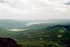
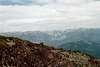
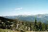
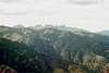
Located on the New Meadows Ranger District of the western Payette National Forest, Pollock Mountain is a far-flung member of the Seven Devils, being separated from most the range by the Rapid River canyon. It rises approximately 4,290 feet above Round Valley and the meandering upper Little Salmon River north of the town of New Meadows. A trail goes all the way to the top, but good boulder scrambling can be had up the south buttress on the blocky basalt. From the top there are spectacular views of the Payette Mountains to the east, broad meadows and West Mountains to the south and the Seven Devils to the north and west. The Wallowa Mountains are visible further west in Oregon.
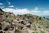
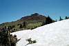
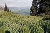
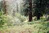
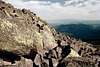
The mountain is formed largely of granite on the western edge of the Idaho Batholith but has a large basalt cap along the ¾ mile long, north-south running summit. Basalt is rare in the Seven Devils, having fallen off the sharply rising summits eons ago. The upper slopes are very open with stunted subalpine fir and whitebark pine; most of the latter have died. The mid slopes support open subalpine fir and spruce on loose gravel and sloughing soils. The subalpine community gives way below to spectacular old growth grand fir in a climax stage of succession. The isolated mountain top is very exposed and catches a lot of weather so be prepared for anything.
There is a low lookout on the south edge of the ridge. Fortunately due to its placement, one doesn’t see it over the large majority of the summit area. The lookout himself is a very friendly guy who will invite you in, show you how to use the maps and equipment to spot smokes and report them to the fire dispatch. I was lucky to help him sight in a fire location, then record and report it during our visit. He says this mountain gets about 15 visitors each summer.
 |  |  |  |
Getting There
To reach Pollock Mountain turn west off from Highway 95 at mile marker 172 onto the Smokey Boulder Road (Forest Service road 074). This point, where the gentle stream of the Little Salmon leaves the broad valley and spills into a waterfall filled gorge, is about 15 minutes north of New Meadows and 30-40 minutes south of Riggins on Highway 95. Continue west on the Smokey Boulder road for about 2.5 miles across the valley to the Payette National Forest boundary. Keep right on the 074 road. After about 4 miles park at the Pollock Mountain trailhead; this is just beyond where road 074 crosses to the west side of Boulder Creek. From this trailhead it’s about a 2 mile hike on trail 179 to Chokecherry Flats. An alternate route to Chokecherry Flats is to continue on the 074 road for about 5 more miles to the 158 road. Turn right on the 158 and continue approximately 8 miles to Chokecherry Flats where the road ends. This route cuts 2 miles off the hike, but adds 13 miles of driving. The final 8 miles on road 158 are rugged and a 4wd vehicle is highly recommended. Road 158 is open all summer, but closes in the fall for hunting season. Check at the Forest Service office listed below for exact dates as they may change over time.
The trail beyond Chokecherry Flats cuts up through old growth forest, then open subalpine forests for almost 2 more miles to the ridgeline. An excellent water source, Cold Springs, is found on the trail a few hundred yards before the ridgeline. Turn right at the top and then keep right as the trail splits. Continue for nearly 1 more mile to the summit of Pollock Mountain.
 |  |  |  |
Red Tape
None.
When To Climb
June until the late fall snows get deep (Oct or Nov).
 |  |  |
Camping
Along most of road 074 there are numerous primitive dispersed camping opportunities.
There are no developed campgrounds in the vicinity of the mountain. The closest are Last Chance Campground, which is approximately 4 miles east of New Meadows on Highway 55 and another 2+ miles north of road 453; Cold Springs Campground, which is approximately 8 miles west of New Meadows on Highway 95 and then about 3 more miles west on road 089; and Evergreen Campground, which is on Highway 95 along the Weiser River, about 12 miles west of New Meadows.
Mountain Conditions
Current mountain conditions and access information can be obtained from the New Meadows District office of the Payette National Forest, (208) 347-0300.
NOAA Forcast
External Links
- Payette National Forest
USFS website.