
-
 16233 Hits
-
 84.82% Score
-
 19 Votes
|
|
Mountain/Rock |
|---|---|
|
|
45.22650°N / 116.558°W |
|
|
Adams |
|
|
Hiking |
|
|
Summer |
|
|
8957 ft / 2730 m |
|
|
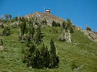
Overview
Monument Peak is the highpoint of Adams County, Idaho as listed by the County Highpoint Organization . The area of Monument Peak is somewhat remote and the easiest approach is from the county seat located in Council, Idaho on Hwy 95. The trailhead is located 50 miles northwest of Council and there are no services (gas, food, beer, etc.) once you leave Council. The trailhead is virtually inaccessible in the winter once the first snow storm blankets the area and is not accessible until late spring when the snow melts.
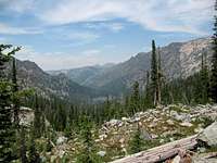
This is a popular area for hunting and fishing along with bird watching and searching for wildflowers. It is a great place to get above the hot valleys to the east and west during the summer. Mountain goats, deer, elk, and bear all frequent the area. I was lucky to see several hawks on the drive and hike into the area.
There are Trip Reports for Monument Peak posted by Dan Robbins at Idaho Summits , and at the County Highpoint Organization under the section for Adams County Trip Reports .
Getting There

Hornet Creek Road is paved and is easy driving. Follow it for about 28 miles to where the pavement ends and the little settlement of Bear is located. There is a little white painted one room school house along the road in Bear and note your mileage here. The gravel road is good and continues up the valley beyond Bear for another 4.3 miles before you turn left on FR 105 with a sign indicating that Black Lake is 15 miles ahead. The trailhead is at Black Lake.

FR 105 is rougher and it starts to climb at 5.1 miles stay left and pass the work center. At 6.0 miles you crest a ridge and there is a historical marker on the left for some old mail cabin that doesn’t exist anymore. Turn hard right here and proceed onto FR 112. There is a sign here that the road is not recommended for passenger cars. If you are driving your wife’s BMW, turn around and go get your old beater car that you use for going to the dump. This road has some rocks in it and high clearance will be an advantage. I’ve seen some SPer’s get their cars up 4WD goat tracks before and this road isn’t that bad. Of course if it is still wet and muddy from the spring thaw, you will have problems. Stay on this road, past the Placer Basin Historical Marker at 8.4 miles, and past the turn off for Smith Lookout at 11.0 miles.
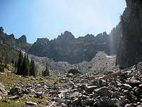
At 12.0 miles you come over a saddle at about 7,400 ft elevation and you can see some mountains off to your front left. That is your destination. Continue and at 16.7 stay left to the lake. The lake is at mile 18.0 from the Bear school. Just past the large Black Lake Campground/Hells Canyon Recreation Area sign is the trailhead on your right. This is where you start your hike, elevation 7,220 ft. There isn’t any parking at the trailhead so go back down the road about 100 yards and turn off to the south and find a place to park.
Red Tape

Council Ranger District Office
PO Box 567
500 East Whitely
Council, Idaho 83612
(208) 253-0100
District Ranger, Mary Farnsworth
Or:
Payette National Forest
Contacts Payette National Forest
Camping

There is no fresh water at the Black Lake Campground and lake water should be treated appropriately before using. There is a vault toilet at Black Lake Campground. When I was there in mid-July 2007, the campground was full on a Thursday night and I car camped near the north end of the lake.
If you want to backpack and camp during the hike, I saw at least one campsite along the trail at Emerald Lake and another one near the little lake north of Emerald Lake. Otherwise there are places to make your own bivy including in the basin at about 7,600 ft elevation at the foot of Monument Peak.
When to Climb

This is a great hike for July through September.
Mountain Conditions

Summertime thunderstorms are a distinct possibility and you will need to pay attention to them. This is a long hike and you may want to be off the exposed ridges if thunderstorms are forecast.
Weather for Council, Idaho