
|
|
Mountain/Rock |
|---|---|
|
|
45.30060°N / 116.5641°W |
|
|
9000 ft / 2743 m |
|
|
Overview
The Twin Imps are two rugged troublemakers on the divide 0.8 miles SSW of Devils Throne. Though they're imps, they're tall imps. Too much growth hormone--too much fattening foods for these devilish lads, me thinks.South Imp (9,000+ ft) is the lower and easier of the two but I did not climb it. Class 3? My approach from the north would have taken too long and required too much of a drop into the basin on the east side. Add to that the uncertainty as to the route to the col between the peaks and I had more than enough reason not to do it. Besides, the higher North Imp was just to my right beckoning me.
North Imp (est. 9,030 ft) is a rocky spire with an aesthetic aspect but with an aseptic asset: there is no easy way up it! With Martin staying behind on Devils Throne with devil's blains on his toes, I scurried over to the Imps to have a look at close range. All I knew was that the North Imp was Class 5. But what level of Class 5? I feel fairly comfortable freeclimbing low 5th, but not anything in the mid to upper 5th range. As I progressed along the "standard" NE Arête Route, checking it out as I went fully expecting to come to an impasse to my abilities, I soon found myself at a point of definite impasse: I could climb no higher without wings, for I was at the summit! To my amazement, I was the fourth party (and first solo) to sign the register since the FA in 1963. The last entry was in September 2001. Albeit, I must preface this surprise with the notion that the register was buried deep within the summit cairn. It is possible persons have climbed the peak and not seen the register.
 |  |  |
Getting There
There are a few ways to get to the vicinity of the Twin Imps. None of them are short. Two are trail approaches; one is cross country. I chose the cross-country route. For purposes of brevity and since I'm no expert on the region, I will provide three approaches from the same starting point, that of the Seven Devils Trailhead and Campground.To get you to this starting point, I will shamelessly quote Martin Cash from his Ogre/Goblin page:
"Drive US95 to the town of Riggins, Idaho. About 1 mile south of town, turn right onto Seven Devils Road, then drive 17.4 miles to the trailhead at Seven Devils Campground at 7,600 feet. The road starts out as paved then becomes steep and winding gravel for the remainder. Watch out for cows on the road, this is a grazing area. Figure on 30 minutes to drive this."
Approach 1: Loop Trail, East Side
This is part of the long trail that loops around the entire wilderness. You want to take the part of it leading south along the east side of the mountains. The trail leads to a feasible cross country final approach to the basin east of the peak.At the trailhead (7,600 ft) across the road to the south is a sign reading "Cannon Lakes Trail No. 101." You want to take this trail. It intially goes downhill. What a drag--especially on the return! This trail might also be known as the Old Boise Trail on maps. Suffice it to say, it's there and it leads initially to Lower Cannon Lake (7,000 ft) in 4 miles. You don't actually want to go to the lake. There should be a junction about 0.5 miles before the lake. You want to continue south along the trail here. Continue about 3 more miles to where it crosses Dog Creek at 7,000 ft. Somewhere near here there should be a spur trail leading west to Dog Lake (7,900 ft), which sleeps at the imps' feet. Expect it to take about 5 hours to reach Dog Lake.
 |
Approach 2: Loop Trail, West Side
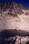
The loop trail leaves the Seven Devils Trailhead (7,600 ft) and initially proceeds north away from the Imps. You'd want to go this way only if you had a lot of time to burn as an "imp in the summer" (pun intended). The trail drops in and out of several basins and in about 9 miles reaches Baldy Lake (7,200 ft) in the basin west of Devils Throne. From this lake the Imps are within striking distance. You could continue along the trail southward for about 2 miles to get closer to the west side of South Imp but I have no idea about the terrain on the west side of the peak. However, based on this picture, it looks like South Imp would be merely a talus walk-up.Approach 3: Dog Creek to Dog Lake
This section is courtesy of Fred and Moni Spicker:It is 7 miles from the trail head at Windy Gap (7,606 ft) to its Dog Creek crossing (7040 ft). The trail starts off downhill – the drop is about 800 ft which must be regained on the way out. Otherwise, the trail gains and looses very little elevation to Dog Creek.
The trail from the main loop trail to Dog Lake is not maintained (USFS calls it a "Social Trail"). It is quite good most of the way but can be hard to follow in places. It is about 1.3 miles from the main trail to the lake with an elevation gain of about 870 ft.
From the east end of Dog Lake, there is a good fisherman’s trail along the north shore. It is about .75 miles and 890 ft of elevation gain from the east end of the lake to the saddle at the bottom of the NE Arete. The saddle is gained by a short steep talus filled couloir or gully that cannot be seen from the lake. It is hidden behind an obvious whitish colored buttress. There are some photos attached to the mountain and route pages.
There is a campsite where the main loop trail crosses Dog Creek and campsites at the lake.
Approach 4: Cross Country from Devils Throne
For the route to Devils Throne, see the Devils Throne page. This is a great route for those wishing to do North Imp.Descend the long talus South Ridge of Devils Throne to an 8,840+ ft saddle at the base of the ridge. Now, contour down and across the west side of the unnamed ridge crags between the Throne and the Imps. This traverse sucks (scree, slabs, hell, you name it); it will probably compel you to take the basins northward on the east side on the return (if you're camped at "Brimstone Lake" SSE of He Devil, for example).
The traverse arrives at a second saddle (8,500 ft) 0.3 miles ENE of North Imp. Continue SSW up the obvious incline (grass, boulders, trees, talus) to the broad ridge saddle east of North Imp. From this saddle, the Northeast Arete Route for the North Imp can be accessed. Or, you can descend a few hundred feet into the Dog Lake basin to get around buttresses in order to traverse over to below the col between the Imps. One look at this traverse and you'll exclaim, "ugh!"
The climb up to the col from the east looked like it featured a step or two of Class 4 in a gully but I couldn't really tell from a distance. Once at the col, the climb would be easy Class 3 scrambling.
 |
Red Tape
No Trail Park Pass required. Imagine that! No permits nor fees to use the wilderness. Nice!When To Climb
Most people enjoy this area in the summer. I'd say anytime after June 1 ought to give you most of the access you need. Clearly, the earlier it is the more snow will impede or aide your travels (it could cover some of that annoying talus and scree). Ice axe probably mandatory in early season. However, summer means less water availibility and/or the need to filter.Camping
The trailhead is comprised of an upper and lower campground. The lower one down by Seven Devils Lake can be crowded. The upper one is by the trailhead. Or, if everything's taken, there's ample grassy space to throw it down.In the wilderness itself, you can camp anywhere you like. A lot of the terrain is rocky but the basins offer flat aspects and grassy benches, etc. Some lakes dry up as the summer progressses. Also, not all of the drainages have active creeks in them. This be almost desert country, ya know.
As mentioned in Approach 3, there is a small lake we've coined "Brimstone Lake" SSE of He Devil that is an excellent staging area for bagging those devilish peaks. Both Baldy and Dog lakes look like fine camping locations.
 |
Mountain Conditions
You can call the Hells Canyon National Recreation Area at 208-628-3916 for info.Riggins Weather (nearest town but may not be representative of weather conditions in the Seven Devils)
Fred Spicker - Aug 22, 2011 10:59 am - Voted 10/10
Dog Lake approachMore details on the Dog Lake Approach - It is 7 miles from the trail head at Windy Gap (7,606 ft) to its Dog Creek crossing (7040 ft). The trail starts off downhill – the drop is about 800 ft which must be regained on the way out. Otherwise, the trail gains and looses very little elevation to Dog Creek. The trail from the main loop trail to Dog Lake is not maintained (USFS calls it a "Social Trail"). It is quite good most of the way but can be hard to follow in places. It is about 1.3 miles from the main trail to the lake with an elevation gain of about 870 ft. From the east end of Dog Lake, there is a good fisherman’s trail along the north shore. It is about .75 miles and 890 ft of elevation gain from the east end of the lake to the saddle at the bottom of the NE Arete. The saddle is gained by a short steep talus filled couloir or gully that cannot be seen from the lake. It is hidden behind an obvious whitish colored buttress. There are some photos attached to the mountain and route pages. There is a campsite where the main loop trail crosses Dog Creek and campsites at the lake.