
|
|
Area/Range |
|---|---|
|
|
45.32300°N / 116.544°W |
|
|
Overview
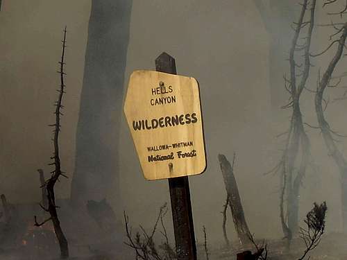
Much of the Hells Canyon Wilderness and the Seven Devils Mountains burned in 2006
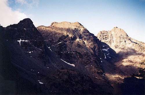 Left to right: Mt. Baal, She Devil, He Devil in the morning light. Photo by Klenke
  |
 |
 |
 |
 |
 |
The Seven Devils Mountains extend along the Idaho/Oregon border for about 50 miles roughly between the Idaho towns of Whitebird and Council. The Snake River through Hells Canyon forms the west boundary and the Salmon and Little Salmon rivers bound the east. The range is one of the more rugged of Idaho’s mountain chains and is probably the state's most precipitous with elevations varying from just above 1,000 feet at the Snake River to 9,420 feet at the summit of He Devil. He Devil is one of three peaks in Idaho with over 5,000 feet of prominence. The vertical rise of approximately 8,000 feet in eight horizontal miles from the bottom of Hells Canyon is the highest in the state. He Devil and adjacent She Devil are basically equal in height but have never been officially triangulated. Most books and maps incorrectly list them at 9,393 feet and 9,280 feet respectively, though USGS quad maps show both exceeding the 9,400 contour. Though He Devil appears slightly higher of the two, it is possible that She Devil is the highest.
The central portion of the range contains the highest and most rugged mountains. These are cleverly named the likes of He Devil, She Devil, The Ogre, Tower of Babel, Twin Imps, The Goblin, Devils Throne and Devils Tooth. A 27 mile long loop trail encircles this spectacular area making for a tremendous extended hike with many hiking and scrambling opportunities. Don’t expect solitude at the larger lakes or along this trail. However, there is much more to these mountains than the very popular central portion. The southern mountains are nearly as rugged and not as heavily used. The northern extent is relatively gentle, but still provides fairly high elevations and some local areas of spectacular terrain where it is easy to get lost for days and not see anyone. In all directions the side ridges and canyons that radiate off the main Snake/Salmon divide provide some of the most remote and rugged ground anywhere.
 |
 |
 |
 |
 |
 |
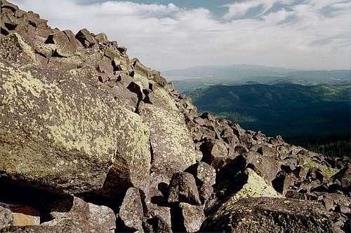
The peaks are generally formed of undifferentiated rock that forms a deteriorated rock strata, of outcrops, towers, extensive talus and scree slopes and bedrock. Climbing opportunities are diverse, ranging from easy Class 1 hikes to Class 5 climbs. Route finding in this varied rock can be very challenging with many dead ends, vanishing ledges and loose rocks. Climbing is a combination of sliding in scree, boulder-hopping, and climbing short, broken ledges. Technical climbing opportunities are limited by the loose rock that clutters every ledge, shelf, or ridge top. Using a rope for protection would, in most instances, invite rockfall which would more than likely destroy the rope or injure the climber.
In 1975, Congress established the Hells Canyon National Recreation Area, which includes much of the range, Hells Canyon and adjacent areas of both Idaho and Washington. Also includes the Hells Canyon Wilderness. Of the 213,993 wilderness acres, approximately 60,000 acres are included in the Seven Devils on the Idaho side of the Snake River.
The Seven Devils are located mostly on the Nez Perce National Forest, but the Hells Canyon NRA and wilderness are managed by the Wallowa-Whitman National Forest. The southern part of the range is on the Payette National Forest.
 |
 |
 |
 |
 |
 |
 |
Access

Northwest slope of The Ogre.

Heaven's Gate Trail
The Seven Devils Wilderness is quite remote with very few access points. Most approaches to the mountains are off the Windy Saddle trailhead. This access point is reached by taking forest road 517 which leaves Hwy 95 just south of the town of Riggins, Idaho. It is 17 miles from Hwy 95 to Windy Saddle. Click here for directions to other trailheads. The main trails used to access the peaks and lakes are listed here.
Hiking and climbing opportunities are above average. Due to the large elevation differentials, the Seven Devils have the longest hiking season of any Idaho mountain range, with hiking beginning along the warm Snake River in early March. The Snake River National Recreation Trail (#102) follows the Wild and Scenic Snake River south for 29 miles, from Pittsburg Landing to the Hells Canyon Dam. Some trails connect to this and provide early season access to the western slopes of the Seven Devils. The Seven Devils Loop Trail (Trails 124 and 101) circles the major peaks for 27 miles of hiking. Side and feeder trails lead to many of the high mountain lakes and provide access to the bases of most peaks.
Refer to the Getting There section of the individual mountain page for the peak you wish visit for specific information and other potential access points.
History
The lower elevations and canyons of the Seven Devils began to be settled in the mid to late 1800s, especially after the Nez Perce War. These homesteaders used the low and mid ranges for cattle grazing and the mid and upper elevations for sheep. Some areas were also logged and a few mines exist. The main ridge tops were the sites of trails that were used for transportation instead of the up and down side canyons. The historic Boise Trail was the main north south route through this part of Idaho before roads were built in the bottom of the Salmon Canyon. The highest elevations would not have been utilized extensively and probably served little human purpose until people realized recreation.

Historic Boise Trail
It is not certain who began climbing in the Seven Devils, but the first record of an ascent of He Devil was by Harold St. John, a professor of botany at Washington State College (later Washington State University) and his student Lowell A. Mullen. St. John and Mullen mounted an eleven day collecting foray into the mountains using a packer-guide. Collection labels indicate that on July 24, 1927, specimens were taken from the summit of He Devil.
The first ascent of The Goblin was by A.H. Marshall and Ed Hughes in August 1935. Marshal also recorded the first ascent of the Tower of Babel in June of 1939. When he climbed The Ogre in 1943 he found a cairn placed on top, but by who is unknown.
Geology
Pollock Mt. is one of the few places in the Sevel Devils where flow basalts can be seen.
The high peaks of the Seven Devils contain volcaniclastic rocks, graywackle and argillite pertaining to the Wild Sheep Creek Formation. These rocks were erupted from the basaltic islands and seamounts in the Permian and Triassic times around 250 million years ago. Fossil and magnetic field investigations indicate the place of origin was somewhere between Guatemala and Peru. The sedimentary rocks formed as the islands eroded and deposited debris around their coasts and can be seen as limestone today. These metavolcanic rocks form a mass that is more than 3,000 feet thick in the Seven Devils. Igneous intrusions along the boundary between these island masses and the North American plate indicate the two collided about 100 million years ago. These light colored granite-like intrusions can be found in many areas in the Seven Devils including Devils Farm to Three Creek Divide, White Monument, Echols Mountain and other areas.
During the Miocene Epoch of the Tertiary Period, massive eruptions of Columbia River flood basalts from present day Washington and Oregon covered expansive areas of the inland northwest. The eruptions lasted about 2 million years from 17 to 14 million years ago. Multiple eruptions deposited the basalt in the layers visible today in the large canyons that bound the mountain range. The red color bands between the flows is indicative of the heat the baked the soils and ashes of plant and animal communities that formed between eruptive episodes.

Limestone Cave
Over the past 6 million years ago, the modern range was formed by block faulting and uplift of the region's very complicated rock layers, which contain a little of everything, from oceanic sedimentary rocks to intrusive igneous rock and limestone caves, all within walking distance of each other. While the Seven Devils block was uplifting, the Salmon River cut an immense trench on the east side of the range. The Snake River initially drained westward through Oregon or possibly Nevada and northern California before finding north-south fault lines and rapidly cutting its present path through Hells Canyon. The central portion of the range rose so sharply that little basalt remains having eroded off. The basalt cap remains however on the gentler slopes of the northern and far southern extensions of the range.
The final major event that shaped the modern Seven Devils was the Pleistocene glaciation. The effects of this activity are evident everywhere in the upper elevations of the range, where there are dozens of prominent cirques and numerous mountain lakes. Large moraines lie both east and west of the central /Seven Devils, mostly below 6,500 feet elevation and now are mostly covered by forest.
Climate


Several climatic zones are represented in west central Idaho resulting from the extremes in elevation, geographic variation, and topographic diversity throughout the area. Deep canyons in close proximity to high mountains often create climatic variations over short distances. However the major influence to the regional climate comes from the Cascade Mountains lying nearly 200 miles to the west. This mountain range forms a barrier against modifying effects of moist winds from the Pacific Ocean and, as a result, the climate of the area is essentially dry. In general the climate for much of the area is categorized as temperate continental. Light precipitation, low relative humidity, rapid evaporation, abundant sunshine, and wide ranges in temperature are characteristic for this climate type. But there are marked local differences in temperature and precipitation owing to local topography.
The Seven Devils entrap about 45 inches of precipitation per year. The narrow uplift, along with the orientation of the range on the lee side and adjacent to the more massive Wallowa Mountains limits the moisture that falls here. The northern part of the range is freer of the Wallowas and more in line with maritime weather flows through the Cascades at the Columbia River Gorge. Thus the northern parts of the Seven Devils are slightly moister than the central and especially the southern areas.
To obtain current weather conditions for a peak you wish to visit, refer to the appropriate mountain page.
Flora/Fauna
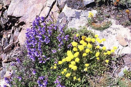
An endemic variety of bush penstemon and yellow buckwheat.
The abrupt rise of these mountains crosses multiple ecological zones (7 to 9 depending on how they are counted) that range from hot desert canyons to the alpine. The lower elevations are comprised of hot canyons with riparian shrub communities. The slopes are bunchgrass with numerous basalt outcrops and rims. Slopes that retain more moisture support assorted shrub communities and eventually trees. Generally these occur with increases in elevation, but slope, aspect and topographic position and shape also determine vegetation placement.
The lower forests are open savannas of ponderosa pine. These give way to Douglas fir and eventually grand fir up higher and on moister slopes. The higher elevation communities are formed of cooler lodgepole pine, subalpine fir and western larch. Depending on the temperature and moisture levels, various forest communities can dominate. Spruce occupies cold slopes and some riparian bottoms where cold air collects. The highest forests form open parklands of subalpine fir and whitebark pine. This latter species is very important to ecological function and wildlife, but unfortunately is in severe decline due to introduced disease, insect attacks and suppression of rejuvenating wildfire.
 |
 |
 |
 |
 |
 |
 |
The highest elevations are dominated by a mosaic of outcrops, turf, scree and barrens that support very unusual plants that are adapted to the short harsh growing season. Some of these species are typical of alpine habitats; however there are no true vegetative alpine communities developed even on the highest peaks. Weather-beaten and runty whitebark pine and subalpine fir grow in rock crevices atop the highest points. And because of the steep upper slope gradients that characterize the severe erosional stress, there appears to be none of the perched and poorly drained small plateaus or soil development that might support tundra vegetation that is sometimes found elsewhere at these elevations. Fellfields and turf are rarely found, but occur to some small extent along the craggy peaks and ridge tops.
 |
 |
 |
 |
 |
There are a number of other specialty habitats scattered throughout the range that make this an extremely diverse area floristically that contains a number of rare or uncommon species. Many are regional endemics found only in the mountains and canyons of west-central Idaho and adjacent Oregon, while a few local endemics have a global range limited to the high mountains or the lower elevation canyon grasslands. Due to geographic placement of the mountains, unusual occurrences of Rocky Mountain, coastal, and great basin species can also be found here.
The diverse habitats also support a variety of wildlife species. Mule deer, whitetail deer and black bear are common. Bighorn sheep also use the mountains and the large river canyons below. Mountain goats have become very abundant in some areas and can actually contribute to the local destruction of sensitive subalpine habitats through trampling. The mid and lower slopes are frequented by elk. Moose are very rare on the peninsula between the Salmon and Snake rivers, but some have been seen. The most common predators are mountain lions, coyotes and bobcats. However rare wolverines are also believed to be present. In recent years wolves have dispersed into the Seven Devils from the expanding populations in central Idaho and two packs are documented to be present. The presence of the wolves has altered the behavior of the prey species. Elk tend to congregate in larger groups than before and they tend to spend more time in open habitats where approaching predators can be better seen.
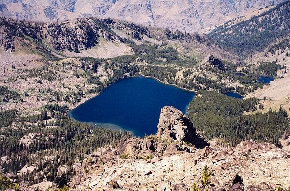
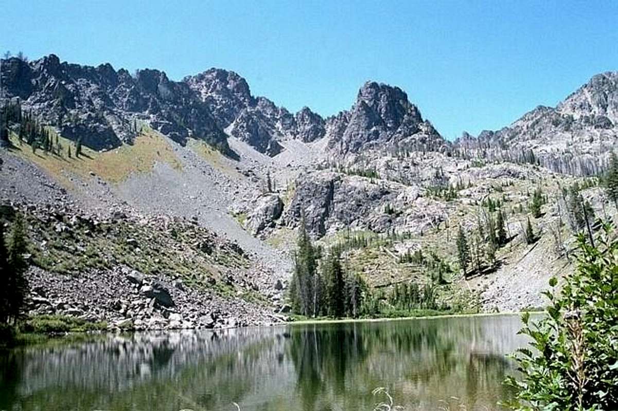
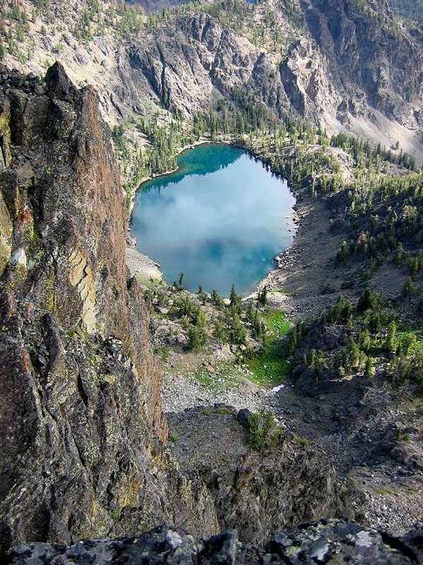
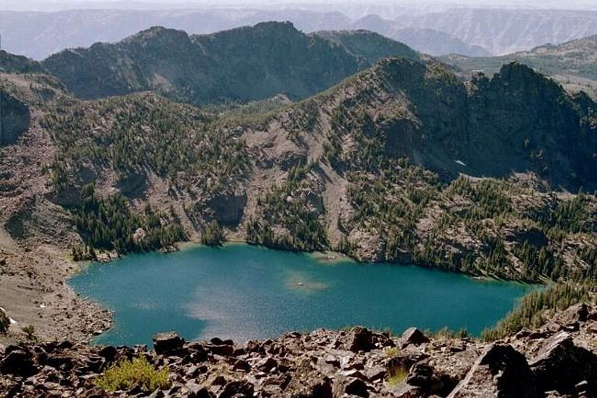
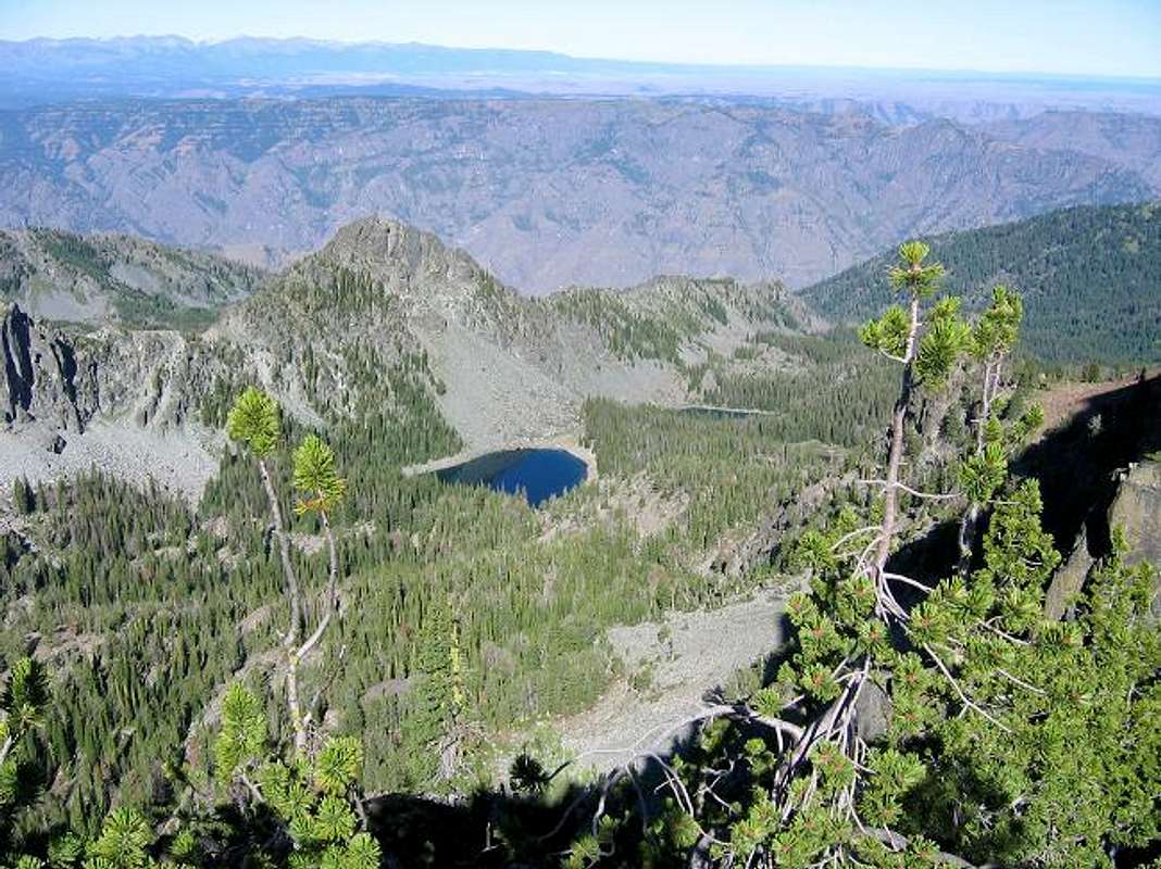
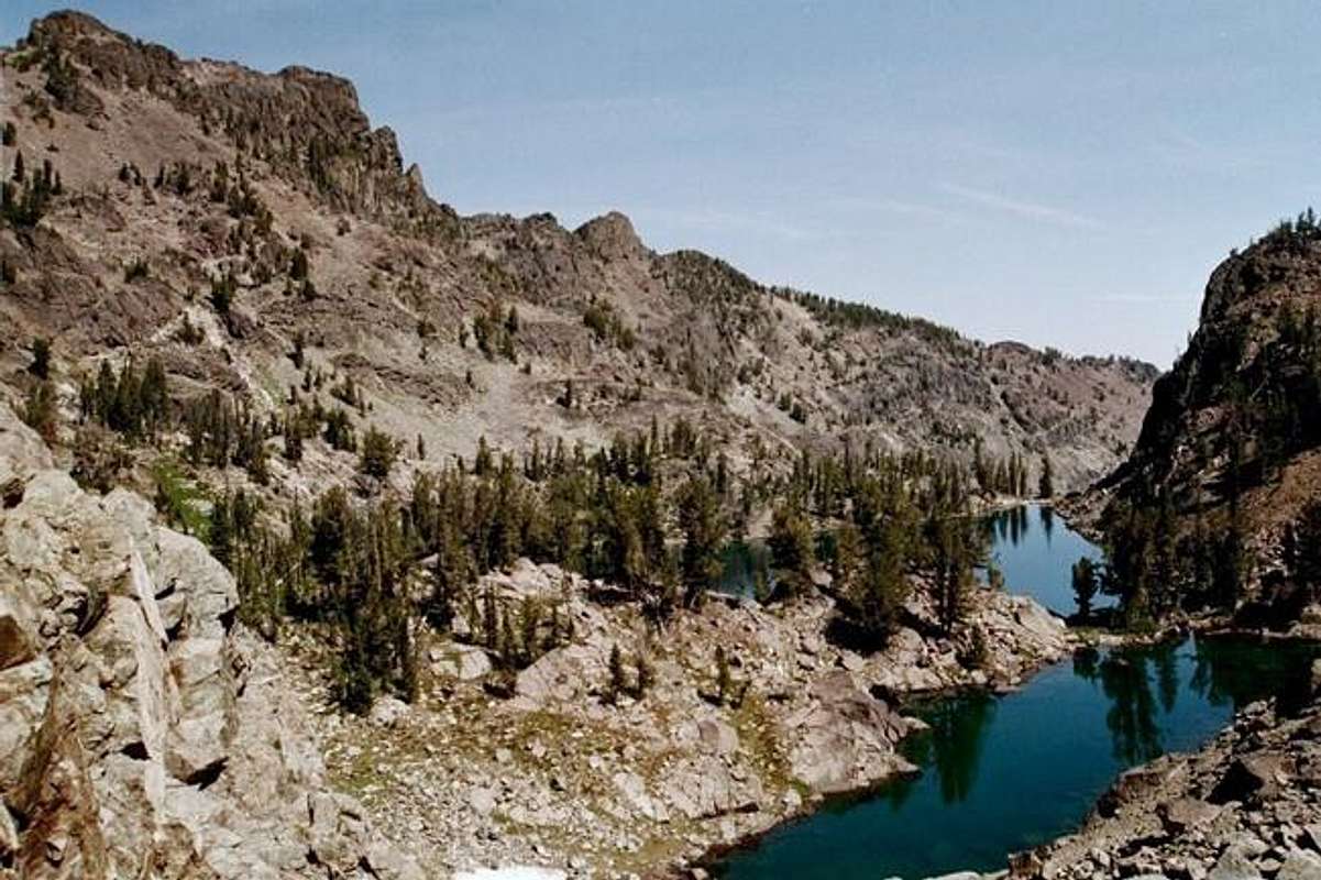
Lakes
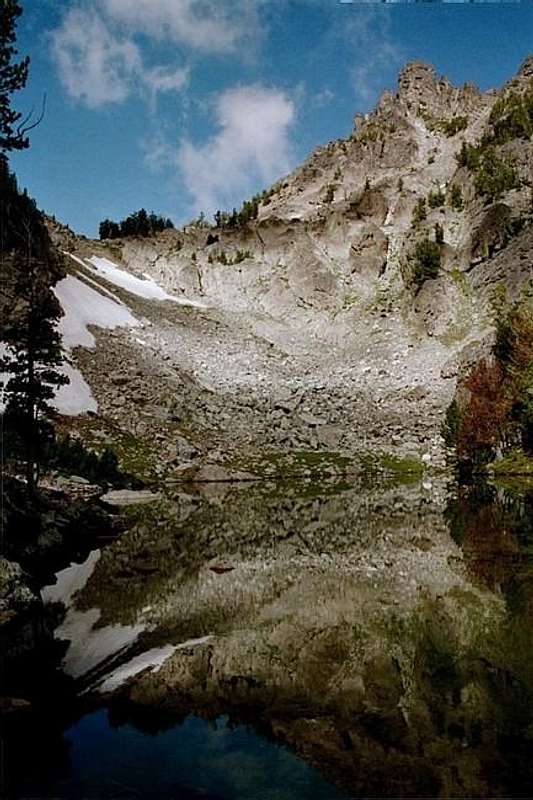
The pond west of Upper Cannon Lake reflects the east buttress of She Devil in the morning light.
Depending on how they are counted, there are approximately 56 lakes in the Seven-Devils. Many are noted to have excellent fishing. Most require moderate to extensive hiking to reach. Some are very remote and require difficult cross country hiking to reach. Many of these provide the best camping and staging areas in the mountains. To avoid resource damage, please camp away from the water and moist meadows that may be associated with the lakes.
Appendix Lake
Baldy Lake with 3 ponds
Basin Lake
Bernard Lakes (2 + 3 ponds)
Black Lake
Crater Lake
Crystal Lake
Dog Lake
Echo Lake
Emerald Lake
Gem Lake
Haas Lake
Hanson Lakes (2)
He Devil Lake
Horse Heaven Lake
Lily Pad Lake
Lower Cannon Lake
Mirror Lake
Papoose Lake
Purgatory Lake
Quad Lake
Rock Island Lake
Ruth Lake
Satan Lake
Seven Devils Lake
Sheep Lake
Shelf Lake
Six Lake Basin
Slide Rock Lake
Twin Lakes (2)
Triangle Lake
Unnamed (Black Imp)
Unnamed (Brimstone Lake)
Unnamed (Casey Mt.)
Unnamed (Granite Fork)
Unnamed (Horse Pasture Basin)
Unnamed (Oxbow Creek)
Unnamed (Paradise Lake)
Unnamed (Purgatory Saddle)
Unnamed (Rock Creek)
Unnamed (below Slide Rock)
Upper Cannon Lake
Upper Cannon pond (south)
Upper cannon pond (west)
Lake Winifred
Camping

Windy Saddle
At large camping is allowed anywhere in the Seven Devils Mountains, but most suitable sites require a long hike into subalpine lakes or basins. Standard wilderness regulations apply concerning placement of camps near lakes.
There are very few designated campgrounds. The primitive Windy Pass Campground (9 tent sites) and the nearby Seven Devils Campground (10 tent sites) are near the end of the 517 road, about 17 miles west of Highway 95. Papoose Campground is at the east base of the mountains along the 517 road just inside the boundary of the Nez Perce National Forest. Black Lake Campground is in the southern Seven Devils.
Refer here for other campgrounds in the general vicinity of the Seven Devils Mountains and Hells Canyon.
For more details about potential camping areas refer to the individual mountain pages for the area to be visited.
Red Tape
There are no fees to access the Seven Devils Wilderness, but regulations and backcountry etiquette information as follows:
Know the Hells Canyon Wilderness Regulations.
Avoid camping in overcrowded and fragile places.
Camp and keep stock at least 200 horizontal feet from lakes and streams.
Pack out all garbage.
Dismantle all structures - such as meat racks or tent poles - before leaving. If these are needed, be sure to use soft rope (instead of nails or wire) to avoid damage to live trees.
Don't build a fire ring. Naturalize the fire site by covering the cold remains of your fire. The best technique of all is to use a portable camp stove.
Dig shallow holes 6 to 8 inches for human waste. Cover with dirt, and decomposition will occur naturally.
Always do whatever you can to move lightly over the land.
Additional Information
Wallowa-Whitman National Forest
P.O. Box 907 / 1550 Dewey Avenue
Baker City, Oregon 97814
TDD (541) 523-1405
(541) 523-6391
Nez Perce National Forest
Rte 2 Box 475
Grangeville ID 83530
(208) 983-1950
Payette National Forest
PO Box 1026
800 West Lakeside Ave
McCall, ID 83638
(208) 634-0700
Hells Canyon National Recreation Area Headquarters/Wallowa Mountains Visitor Center
88401 Hwy 82
Enterprise, OR 97828
Phone: (541) 426-5546 Fax: (541) 426-5522
Hells Canyon National Recreation Area - Idaho Office
P.O. Box 832
Riggins, ID 83549
Phone: (208) 628-3916 Fax: (208) 628-3030
References
Northwest Exposures. A Geologic Story of the Pacific Northwest, by David Alt and Donald W. Hyndman.
ISBN: 0878423230
Plants of the Seven Devils Mountains of Idaho – An Annotated Checklist, by Richard T. Bingham.
USDA Forest Service, GTR INT-219
Alpine and Subalpine Vegetation of the Wallowa, Seven Devils, and Blue Mountains, by Charles G. Johnson.
USDA Forest Service, R6-NR-ECOL-TP-03-04
Exploring Idaho’s Mountains, A Guide for Climbers, Scramblers and Hikers, by Tom Lopez
ISBN: 0898862353