
|
|
Mountain/Rock |
|---|---|
|
|
42.58039°N / 0.12360°E |
|
|
Sobrarbe |
|
|
Hiking, Mixed, Scrambling |
|
|
Spring, Summer, Fall |
|
|
6608 ft / 2014 m |
|
|
Overview
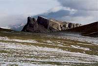 from the Sestrales
 from Lamiana
The Castillo Mayor, despite not high, is a very charismatic and original moutain of the High Aragon.
 The ridge
 The ridge
 Castillo Mayor and the raftmen of the Rio Cinca
 Castillo Mayor and the raftmen of the Rio Cinca
It is a wide inclined limestone platform, all circumvented by cliffs and ship-shaped, jutting above the Rio Airés and the Gorges of Escuaín. A "perched synclinal", say the geologs; in other words, a slice of limestone spared by ice erosion.
It has roughly the shape of a speedboat, that leads towards the north and the main range of the Pyrenees.
The back of the speedboat is the only defect in its defense, in which is going the only route to ascend it, with easy scrambles through. However, it is common to meet some cattle in the middle meadow.
In the central depression is located a curious geologic feature, the waters are escaping not by some water stream, but by two holes, sort of geologic wells, just like two nostrils.
The summit is more exactly a bit like a ridge walk, which offer first class viewpoints to all the southers side of Monte Perdido, and all famous canyons of the region.
Note: there is another famous "Castillo" in the Pyrenees of Aragon: the Castillo de Acher. More than a simple homonym, this other mountain also has a similar shape ("perched synclinal").
Routes
 Start of the trail Start of the trail |
 Castillo Mayor from the South Castillo Mayor from the South |
 Start of the trail Start of the trail |
 Castillo Mayor from the South Castillo Mayor from the South |
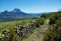
 From Tella
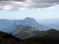 From the Custodia
The most difficult of this mountain is to find the starting point ! There are many possibilities but more or less practical...
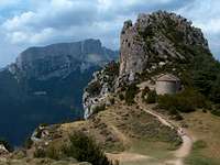
 The summit
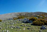
 The central meadow
Arriving by car, leave Puertolas and continue forward, leave on the right the junction going to Escuaín, and go in the direction of Bestué. Soon, after a little pass, we see a small non-asphalted track on the right; drive it some 700m until you cannot go any further and park the car.
 Looking to the canyons
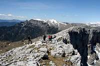 Walking the ridges
Walk the track 5mn until you see a little cattle-watering fountain. This place can be reached via a very old trail that starts some 500m further on the asphalted road we took (but, personal note from the author, I don't recommend it, the track is not maintained, almost invisible and very uncomfortable).
On the other hand, its continuation on the right is well maintained, and this is the way we need to follow now whatever was the starting point. It goes through screes and harsh bush.
Then we reach the foot of the cliffs of the Castillo Mayor, and we need to take left under them, until we get to a point that allows reaching the upper level.
Then, after crossing few trees and small vegetation, we enter the wide inclided meadow that forms the top of the Castillo Mayor.
Then, the ideal walk "over" the Castillo Mayor consists in walking all the circumference of the table of the mountain. The best is to start from right (East side) to reach the summit first. There are several ups and downs with secondary tops before we reach the main one.
Later, you get to the very north end of the Castillo Mayor, where you stand like on the bow of a boat, overlooking the lone pinnacle that precede it (Peña de l'Ombre).
When returning, keep folowing the West side of the Castillo Mayor until you get back to the central depression (with the 2 nostrils), and then the exit.
SP Member Rafa Bartolome proposed another route whose details are in the picture below, with a red line corresponding the GPS positions. The particularity of this route is to go directly over the cliffs of Sensa instead of reaching their base first.
Beware during all this hike, walking on the plateau is extremely tiring, as it is made of cracked porous limestone chaos, where one always must beware to choose the right steps. If there are some slices of snow, it can be even dangerous, because the snow can mask the holes.
The most adventurous can try to find out if there is a second way to get into the Castillo Mayor: As seen from the West, the central plateau seems divided in two units, between which is located what seems to be another friendly slope. However, nowhere is mnetionned about the existence of such route.
 |
 Monte Perdido, Tres Marias, Gorges of Escuaín from the Castillo Mayor Monte Perdido, Tres Marias, Gorges of Escuaín from the Castillo Mayor |
 Rafa Bartolome's GPS route over the cliffs Rafa Bartolome's GPS route over the cliffs |
Getting There
 Central meadow
 Central meadow
 Peña l'Ombre
  Summit
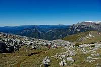 South East pass
 Escuaín below
To climb the Castillo Mayor, one must reach the village of Puertolas.
Puertolas is accessible from the junction of Laspuña on the A-138 road going from Aínsa to the border tunnel to France.
If you arrive from France, this tunnel is accessible from the Vallée d'Aure (Lannemezan exit on the A64). Beware, the tunnel is closed from 8am to 20pm.
Agrandir le plan
Red Tape
 The walls
 Monte Perdido
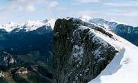 Looking South
No specific regulations in this area.
If you plan to rockclimb some cliffs of the Castillo Mayor, beware, the stone is very loose.
As mentionned, beware when walking in the snow.
 From Escuaín From Escuaín |
Camping
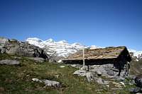 Hut
Hut Canyon de anisclo
The nearest official campsite is located in Lafortunada, at the junction going to the Cañón de Añisclo.
As for wild camping, the regulations are unclear, but considering the frequentation of this mountain, there is no worry to have at all... except finding a flat place for the tent :)
One can find accomodations in Bestué, in Escuaín, and in Lamiana.
Rafa Bartolome - May 22, 2009 10:02 am - Voted 10/10
linkyou can add the link of my page about this peak in Spanish if you want: http://www.mendikat.net/monte.php?numero=920es Castillo Mayor