First, Mt. Hood
This trip had originally been conceived as an attempt to climb Mt Rainier in Washington state (14,411’) and whatever else time would permit. However, as the trip approached, several factors prompted us to shelve Rainier in favor of a pair of simpler targets: Oregon’s Mount Hood (11,237’) and Washington’s Mt Adams (12,276’). Both of these peaks offer simple technical climbs involving glacier travel, something we don’t get to do in Colorado.
After arriving in Seattle, we decided to head south for Mt Hood. We figured on working our way back toward Seattle as the trip progressed. We arrived at Mt Hood by late afternoon, early enough to drive up to the trailhead and preview our climbing route. Hood is most striking when viewed from Portland to the west where it shoots 10,000’ up from the surrounding plains to a pointy summit. Viewed from closeup, it looks like a steep mountain with snow on it and that’s about it. We found a campsite just below treeline and got ourselves packed and ready for the 2AM start time. We were carrying just about everything imaginable for the climb, including a rope plus snow and rock protection should anchors be necessary.
Waking up at 1AM was awful. The perfect weather of the day before had given way to a massive, unpredicted windstorm, filling the air with choking dust. I made a half-hearted suggestion to scrap the climb on weather concerns, but since we were already awake, the damage was done. Steve, one of my two climbing partners, decided to forego the climb due to a lingering case of tendonitis in his ankle, so it was going to be Jon and I forging into this storm. We got up to the trailhead at 2AM with the winds at full fury. The climb begins above treeline, so there was nothing to block the wind whatsoever. As we set off, the source of the blowing dust became apparent – Mt Hood is basically a giant pile of kitty litter. The mountain is composed of completely disintegrated pumice and volcanic ash. Off-snow climbing was an insulting effort akin to walking up an endless beach. The snow was not much better since warm overnight temperatures had failed to freeze the snow surface.
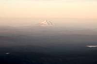
![Sunrise on Mt Jefferson]()
![The Old Chute on Mt Hood]()
The whole situation was surreal; climbing in the middle of the night in a windstorm through an active ski area on a volcano that still belched noxious sulfur fumes. The trail we were following runs through the heart of the Timberline ski area, a year-round operation on the Palmer snowfield that is famous for its summer racing camps. We soldiered upward following the light of our headlamps, occasionally scurrying away from the blinding light of approaching snow groomers. Around 3:30AM, the windstorm peaked with gusts strong enough to stop me in my tracks. I registered my disgust and desire to turn around with Jon who suggested at least persevering until daylight came in perhaps another hour or so. I agreed, and on we went.
![The Bergschrund on Mt Hood]()
![Adams and Rainier from Hood]()
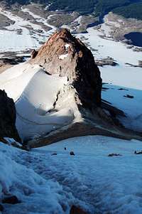
Daylight found us hunkered behind the lift building that marked the top of the ski area. Above this point, the rest of the mountain is unmaintained and uncontrolled. In a miraculous fashion, the wind had noticeably abated in the previous half hour. My spirits improved considerably and I offered my support for a summit attempt. We made steady time above the ski area as we cramponed our way over the upper Palmer Snowfield. Around 6AM, we arrived at Hood’s famed summit pitch. Easy access to the summit is barred by a cliff band known as the Pearly Gates due to the thick, puffy coatings of rime ice they accumulate in winter time. A narrow knife-edge of snow called the Hogsback used to lead directly through the Pearly Gates, allowing a remarkably simple snow climb to Hood’s summit. In recent years, the Hogsback had shifted left, making direct ascent through the cliff band difficult. We chose to follow an alternative route called the Old Chute. It required a traverse beneath the Pearly Gates to a moderately steep couloir that leads to the summit ridge. The National Forest Service conditions report warned that this chute was becoming icy which was why we chose to carry ropes and gear in the first place. We began the final push with some caution.
![Descending the Old Chute on Hood]()
![The Lowest Point in Oregon]()
The first obstacle was crossing the bergschrund, the uppermost glacial crevasse that marks the line between static and moving snow. There was still a solid snow bridge, so the crossing was simple. Jon and I followed a well-trodden set of switchbacks up the chute that provided excellent crampon traction and convenient holes for ice ax self-belay. We never found the icy section – perhaps it was just fluff to scare tourists away. At 7:20AM, we were on the summit ridge and ten minutes later we were on the summit itself. It was a far, far simpler climb than we had anticipated. I was glad I didn’t give up during those desperate nighttime hours. The view from the summit was unique and spectacular with snow-capped volcanoes to the north and south like islands in the sky. Well worth the effort to get up there.
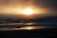
The descent was unremarkable, save for the indignity of having to walk downhill through a bustling ski area. That’s the worst kind of torture. Oh, and Jon’s right crampon fell 30 feet down a crevasse, but these things happen. We rejoined Steve at our campsite and packed up. To round out the day, we headed from Oregon’s highest point to her lowest point, the ocean. Our neighbors at the campsite provided the entertainment that evening, brandishing a rifle, offering us alcohol and marijuana, and almost getting in a knife fight. They were teenagers….
Second, the North Cascades
The next morning brought the next change of plans. Steve learned of a family emergency, necessitating our return to Seattle so that he could fly home. For Jon and I to climb Mt Adams, we would have to drive almost all the way back to Oregon, so we scrapped that idea. After dropping Steve off at Sea-Tac, we headed north for the North Cascades, one of the most rugged mountain ranges in the US. We decided to take a shot at a few simpler peaks just north of Mt Baker (home of the world snowfall record – 95’ of Cascade Concrete). Our first target was Tomyhoi Peak (7,456’), a mountain whose pronunciation eluded us.
![Tomyhoi Peak]()
![The Tomyhoi Glacier]()
We awoke at a luxurious 4:30AM and were hiking by 5. The trail made a steep ascent through a forest whose undergrowth was far denser than we were used to in Colorado. We eventually emerged into a snow-choked basin filled with tiny glacial lakes. We ascended to a high, broad ridge that rose endlessly toward the tiny summit. Just below the summit, we were forced to traverse a large snowfield to the now narrow summit ridge. We traversed under a large rock tower to a false summit with a view of the final climb. It looked vertical and impossible. Jon chose to sit it out while I attempted the summit pitch. I crossed the narrow gap between the false summit and the main summit and started up the wall. It looked much worse than it was. I quickly made it up the last pitch and traversed to the very top of the peak. The summit was surrounded on all sides by vertical drop-offs. It was probably the scariest summit I’ve ever been on. I stopped long enough to grab a bite to eat and snap a bunch of photos of the scenery. The views were amazing, with rugged peaks in every direction. Not bad. 20 minutes later I was down the toughest pitch and met up with Jon. We lollygagged back to the trailhead, enjoying our surroundings. No crampons were lost.
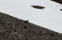
![Wildlife on Tomyhoi]()
![Yellow Asters]()
The next day we intended to climb Mount Ruth (7,106’), a peak that would allow us to climb an easy glacier. The climb was ill-fated from the beginning. I had strained a knee tendon the day before and reaggravated an old upper-back injury. As we arrived at the pass that marked the start of the technical climbing, I had had enough. I urged Jon to continue on without me because I didn’t feel up to completing the climb. I found my way to a high vantage point and kept an eye on Jon. I saw him head up a trail that seemed to lead to nowhere. After 30 minutes of searching for a way to continue, he gave up and headed down. It was lucky too because the winds started gusting and clouds built up very rapidly. By the time we returned to the trailhead, we were hearing claps of thunder and receiving bursts of rain. Mt Ruth will have to wait; next time I will be armed with skis.
And then we returned to civilization in search of a shower. 5 days, 2 summits, infinite views. We’ll be back for Rainier I’m sure.
Comments
No comments posted yet.