
|
|
Mountain/Rock |
|---|---|
|
|
26.8036°S / 68.2775°W |
|
|
19242 ft / 5865 m |
|
|
Overview
The Puna de Atacama is a high plateau with a height of mostly over 4.000 m over sea level. This plateau is approx. 300 kilometres wide and extends from south Bolivia and north Chile into the northwest of Argentina. There are many mountains over 6.000 m, but also very interesting 5.000 summits, e.g. the dos Conos at the Paso de San Francisco. The few of these mountains have permanent snow.The largest problems of climbing are the extreme isolation, the water shortage at most mountains and durable and unpleasant cold weather as well as the violent, continuous wind. All these points should not be underestimated with a climbing.
Since the high plateau of the Puna de Atacama, as previously mentioned, is itself on a height of at least 4.000 m, it is advisable to be acclimatised in other places before entering this region. Who enters via Santiago de Chile, has to do this best conditions around the capital.
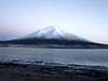
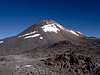
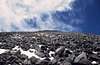
The dos Conos are two neighbouring conical elevations in the Puna de Atacama northern of the Paso de San Francisco. Despite their good accessibility (this, however, requires that one has a 4x4) both summits are climbed only rarely. Also its position in the midst of a fantastic mountain world and the proximity to the Nevado Ojos del Salado in nothing changed even if it is an ideal mountain for acclimatisation. By the proximity to the perhaps simplest 6000m peak of the world, the 6.018m high Cerro de San Francisco, they stand for that inevitably in the offside.
An enormous view on at least twelve 6.000m peaks and innumerable 5000m summits in next environment the dos Conos are for me an insider’s tip. Exactly in the south the Cerro de San Francisco raises, behind it the Cerro de Incahuasi. Further in the southeast are the enormous massifs of the Nevado Ojos del Salado and Cerro Tres Cruces.
 |
Getting There
Dos Conos is attainable from the two largest, international airports of the region: Santiago de Chile and Buenos Aires.From Argentina:
Variant 1:
From Santiago there are several times daily bus connections to Mendoza, (approx. 7 hours), which can be fully booked in the high season in December or January days in advance, however.
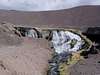
That approx. 150 kilometres distant San Juan can be attained likewise very well with buses. At the latest here one should supply oneself with food supply. Numerous supermarkets have a rich offer; actually one will miss nothing. Also one should carry sufficient quantities of water, since it can be very dry at Laguna Verde and one meets only occasionally clean drinking water and/or snowfields.
The access to the dos Conos does not become so simple. Either one confide oneself in an agency, which represents the more comfortable and safe variant with security. As alternative one can rent a car (4x4) in Mendoza or San Juan and drive on own risk into the region around the Laguna Verde. The advantage is that one is independent and not under time pressure.
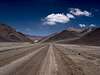
One continues to leave San Juan on the 40 in northern direction over San José de Jáchal to Nonogasta, then over Tinogasta to Fiambalá. From here one drives further to the Paso de San Francisco.
Variante 2:
One flies via Buenos Aires to La Rioja. There one takes a bus to Tinogasta or Fiambalá, where one turns to an agency or rents a car.
On good road one arrives at the Paso de San Francisco.
From Chile:
Either one flies to Santiago, in order to acclimatise oneself here somewhat, or one continues to fly right to Copiapó, an oasis in the midst of the arid coastal strip of Chile.
Also several buses drive several times daily from Santiago to Copiapó. It is recommended to take one of the many night buses.
From Copiapó with the car (rented or with an agency) via the Salar de Maricunga to the Laguna Verde, where there are possibilities to pitch a tent. On the road to Argentina one arrives at the Paso de San Francisco.
 |  |  |  |  |
Red Tape
As of 1 of December 2004, the regional authority licensed the company Aventurismo y Expediciones that is authorized to receive a rate of admission from the national and foreign climbers that wishes to accede to the sector around Laguna Verde. Concerned is the access to the Volcán Ojos del Salado, Cerro el Muerto, Cerro Tres Cruces, Nevado de Incahuasi, Refugios Atacama and Tejos and the termas de Laguna Verde. Consultations can take place in www.aventurismo.clWhen To Climb
The South American winters in the Ojos region are damper and colder, which generally more precipitation means, which can lead even in deeper reaches to snow. On impassable roads must be counted. Additionally low temperatures lead to further difficulties.The summer against is drier and warmer. Balanced conditions could prevail in the spring months from October to December.
The wind can represent particularly in the Ojos region the largest problem. Average is to be expected 2 to 3 windy days per week.
The best time for climbing is the southern summer, i.e. from December to February.
Camping
Camping is possible at each place.Mountain Conditions
The climb:From the Paso de San Francisco one can drive with good conditions (if free of snow) up to over 5.000 meters. From here one climbs in northern direction to the lower, western laid summit or directly to the higher east summit.
Difficulties:
The dos Conos climb concerns simply high mountain climbing without glaciers and technical requirements. Occasionally snowfields must be crossed.
Even if no large, technical demand is made against the mountain climber, one should not underestimate also this mountain. Because of its isolation and inviolacy in case of emergency assistance can arrive only after days.
 |  |  |  |  |
Uwe Kraus - Dec 22, 2005 6:38 pm - Hasn't voted
Untitled CommentWest summit 5.658 m S26°48.552 W68°18.213
ClimberMan420 - Feb 20, 2007 9:43 pm - Hasn't voted
Easy AccessA 4x4 is definetly not necessary, I easily hitchiked solo to the Paso San Francisco and climbed the higher eastern cone from teh refuge in a 10 hour day( already well acclimatzed, I wouldnt count on doing it much faster than 10 hours) and then San Francisco the next day a 7 1/2 hour day. The route was pretty straight forward but some up and downs were hard to avoid as there is a lot of ground to cover to reach the peak. Absolutley wonderful hike, definetly has the feelng that it is rarely climbed. If sleeping in the basic refuge at Paso San fransico it is very drafty, set up the tent inside or bring some fire wood from Las Grutas for extra warmth, and definetly a sleeping matress for the cold concrete floor.