
|
|
Mountain/Rock |
|---|---|
|
|
27.0234°S / 68.6144°W |
|
|
19904 ft / 6067 m |
|
|
Overview
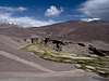
The Puna de Atacama is a high plateau with a height of mostly over 4.000 m over sea level. This plateau is approx. 300 kilometres wide and extends from south Bolivia and north Chile into the northwest of Argentina. There are many mountains over 6.000 m, but also very interesting 5.000 summits, e.g. the dos Conos at the Paso de San Francisco. The few of these mountains have permanent snow.The largest problems of climbing are the extreme isolation, the water shortage at most mountains and durable and unpleasant cold weather as well as the violent, continuous wind. All these points should not be underestimated with a climbing.
Since the high plateau of the Puna de Atacama, as previously mentioned, is itself on a height of at least 4.000 m, it is advisable to be acclimatised in other places before entering this region. Who enters via Santiago de Chile, has to do this best conditions around the capital.
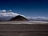
Cerro Vicuñas is a conical mountain in the Puna de Atacama. Just as the Cerros de Barrancas Blancas this mountain is climbed despite its good accessibility (this, however, requires that one has a 4x4) only rarely. Also its position in the midst of a fantastic mountain world and the proximity to the Nevado Ojos del Salado in nothing changed even if it is an ideal mountain to acclimatise. Also from the summit of the Cerro Vicuñas one has a wonderful view over the Puna de Atacama with at least twelve 6.000m summits and innumerable 5.000m peaks. In the southeast is one of the highest volcanoes of the earth; the Nevado Ojos del Salado rises. In the southeast the enormous massif of the Cerro Tres Cruces continues to follow.
 |
Getting There
Cerro Vicuñas is attainable from the two largest, international airports of the region: Santiago de Chile and Buenos Aires.From Argentina:
Variant 1:
From Santiago there are several times daily bus connections to Mendoza, (approx. 7 hours), which can be fully booked in the high season in December or January days in advance, however.
That approx. 150 kilometres distant San Juan can be attained likewise very well with buses. At the latest here one should supply oneself with food supply. Numerous supermarkets have a rich offer; actually one will miss nothing. Also one should carry sufficient quantities of water, since it can be very dry at Laguna Verde and one meets only occasionally clean drinking water and/or snowfields.
The access to the Cerro Vicuñas does not become so simple. Either one confide oneself in an agency, which represents the more comfortable and safe variant with security. As alternative one can rent a car (4x4) in Mendoza or San Juan and drive on own risk into the region around the Laguna Verde. The advantage is that one is independent and not under time pressure.
One continues to leave San Juan on the 40 in northern direction over San José de Jáchal to Nonogasta, then over Tinogasta to Fiambalá. From here one drives further to the Paso de San Francisco. Finally one continues to the Laguna Verde.
Variant 2:
One flies via Buenos Aires to La Rioja. There one takes a bus to Tinogasta or Fiambalá, where one turns to an agency or rents a car.
On good road one arrives at the Paso de San Francisco and continues to the Laguna Verde, starting point for many routes in this region.
From Chile:
Either one flies to Santiago, in order to acclimatise oneself here somewhat, or one continues to fly right to Copiapó, an oasis in the midst of the arid coastal strip of Chile.
Also several buses drive several times daily from Santiago to Copiapó. It is recommended to take one of the many night buses.
From Copiapó with the car (rented or with an agency) via the Salar de Maricunga to the Laguna Verde, where there are possibilities to pitch a tent.
From Laguna Verde:
From the Laguna Verde one drives to the Refugio Atacama toward Ojos del Salado Base Camp. In the Quebrada Ojos del Salado one leaves on a height of approx.. 4,800 meters the runway to the right into a small side valley (tracks), in order to arrive at the foot of the Cerro Vicuñas. One can establish a camp here.
 |  |  |  |  |
Red Tape
As of 1 of December 2004, the regional authority licensed the company Aventurismo y Expediciones that is authorized to receive a rate of admission from the national and foreign climbers that wishes to accede to the sector around Laguna Verde. Concerned is the access to the Volcán Ojos del Salado, Cerro el Muerto, Cerro Tres Cruces, Nevado de Incahuasi, Refugios Atacama and Tejos and the termas de Laguna Verde. Consultations can take place in www.aventurismo.clWhen To Climb
The South American winters in the Ojos region are damper and colder, which generally more precipitation means, which can lead even in deeper reaches to snow. On impassable roads must be counted. Additionally low temperatures lead to further difficulties.The summer against is drier and warmer. Balanced conditions could prevail in the spring months from October to December.
The wind can represent particularly in the Ojos region the largest problem. Average is to be expected 2 to 3 windy days per week.
The best time for climbing is the southern summer, i.e. from December to February.
Camping
Camping is possible at each place.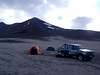 |
Mountain Conditions
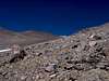
The climb:From the camp one ascends over the clearly visible ridge to southwest. Alternatively the ascent can take place also in the convenient gully south of it. Problem-free one reaches so the summit.
Difficulties:
The Cerro Vicuñas climb concerns simply high mountain climbing without glaciers and technical requirements. Occasionally snowfields must be crossed.
Even if no large, technical demand is made against the mountain climber, one should not underestimate also this mountain. Because of its isolation and inviolacy in case of emergency assistance can arrive only after days.
 |  |  |  |