
-
 8847 Hits
-
 78.27% Score
-
 9 Votes
|
|
Mountain/Rock |
|---|---|
|
|
26.53392°S / 67.0611°W |
|
|
Hiking, Mountaineering |
|
|
Spring, Summer, Fall, Winter |
|
|
19724 ft / 6012 m |
|
|
Overview
Laguna Blanca is an elusive peak in the Catamarca region of Argentina. Until GPS mapping showed that Laguna Blanca was a 6,000er, albeit only just – at 6,012m it is the second lowest 6,000er in the Andes - this peak was largely ignored by hikers and mountaineers. It is easy to understand why, as this is little more than a big lump of scree hidden behind lesser peaks in a remote and little visited corner of NW Argentina. Cerro Laguna Blanca is named after the lake Laguna Blanca which sits at its foot to the southeast.The lake and mountain are part of the Reserva Laguna Blanca, a regional park with one of the highest population densities of vicuñas in the world. Despite its remoteness it is possible to reach the trailhead by public transport and climb the peak supported in 1-2 days or unsupported in 2-3 days. According to the mountaineering museum in Fiambala, the first ascent of Cerro Laguna Blanca was in late 2006, and it has probably received fewer than 10 subsequent ascents.
Getting There
Catamarca is the nearest major city and has regular connections by plane and bus from Buenos Aires. From Catamarca there are 2 or 3 buses per week to Antofagasta de la Sierra that stop at El Peñon on the way. El Peñon (altitude 3,400m) is the village closest to the trailhead. El Peñon has 2 accommodation options (a relatively pricey hosteria and a pension with a very helpful owner), a few shops and a police station. It is possible to buy basic supplies such as tinned food and crackers in El Peñon. From El Peñon to the base of the mountain there are three options: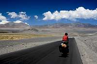 The green oasis on the left of this picture is El Penon. Laguna Blanca is behind the ridge and directly above the rider's head.
 This Quebrada leads all the way from 4,300m to 5,600m and the final climb to the summit.
3) Walk straight from El Peñon to the drop off point where the quebrada emerges from the mountains at 4,300m near the drop off point. This would be an exceedingly boring, and in summer hot, first day crossing a flat plain with no water.
The Route
 Which one is the summit?
 Maybe this one?
Alternative Route
It is also possible to climb Laguna Blanca from the village of Laguna Blanca in 2 to 3 days. If anyone has any information on this route please contact me so I can add the information to this post.Red Tape
There are no permits needed for this peak, however it is wise to inform the local authorities in El Peñon of where you are going and when you expect to be back.When to Climb
The warmest period is between December and March however this climb can be carried out at anytime of year. Crampons and ice axes will probably be necessary during the winter months and a bit of snow on the mountain would make the climb more interesting and worthwhile, as without snow this becomes a trudge up a big rocky mound of a mountain which is at times rather dull.Camping
There are many places to camp along the route and we found water flowing in the quebrada between 4,300m and 5,000m. Above this there are a few penitentes fields from which it is possible to collect ice. Make sure you have a strong tent because there are sometimes crazily strong winds in this area.GPS Points
| Description | Lat | Long | Alt |
| Turned off paved road | 26.54947 S | 67.24422 W | 3,554m |
| First water in quebrada | 26.54766 S | 67.14638 W | 4,290m |
| In quebrada | 26.56193 S | 67.11732 W | 4,702m |
| Follow quebrada to here | 26.53880 S | 67.07209 W | 5,615m |
| Laguna Blanca Central summit | 26.53392 S | 67.06110 W | 6,008m* |
| Laguna Blanca North summit | 26.52995 S | 67.05939 W | 6,007m |
| Laguna Blanca South summit | 26.54250 S | 67.06238 W | 5,995m |
*This is the altitude given by our GPS. The official height is 6,012m.
 The car indicates the drop off point, the yellow line is the way for option 2 and the green line is the way for option 3. The orange line is the route from the drop off point to the summit
 The Route from high camp to the summit.