
|
|
Mountain/Rock |
|---|---|
|
|
28.0188°S / 68.756°W |
|
|
Mountaineering |
|
|
22175 ft / 6759 m |
|
|
Overview
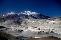 Bonete Chico seen from the north
Bonete Chico is a massive peak by any standards and must be one of the continent's, possibly the world's largest, if measuring the circumference of its base. It's the first of the really high mountains in the Puna area arriving from the south and even though there are quite a lot of high mountains in the close vicinity of Bonete, it's dominating the landscape.
Most of the peaks in the Puna don't have much snow as it is one of the driest areas in the world and Bonete is no exception. On the other hand it has significantly more snow, penitents fields and small glaciers than some of the other peaks in the area.
Because of its remote location it has only been climbed a handful of times. According to new SRTM-studies Bonete is at 6759m the fourth highest peak in South America. On top of the huge bulk of the mountain there's a small summit pyramid, where the climber has to negotiate some easy semi-technical rock climbing to reach the summit. The peak remained unclimbed as late as 1970.
Getting There
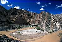 The beautiful canyon after Vincina
Bonete Chico is located far into the wilderness and the only reasonably easy way to get there is to travel to the peak from the south. The last city of any size before the wilderness takes over is Villa Union, which is a pleasant sleepy place where all provisions can be bought. This is also the place for arranging a jeep or 4w vehicle which can take you to the target. The companies who deal with travel to the mountains are all located around the town's main square. The main tourist attraction in the area is Laguna Brava, a super-saline lake with beautiful colours. To travel there is easy to arrange, but demand for going to the mountains beyond is very low. There are tours to Caldera del Inca, the highest water-filled crater in the world and also the area’s second most popular tourist attraction. The crater is further into the wilderness than Bonete Chico.
Check the prices for a tour to the Caldera and subtract roughly a hundred Pesos and that's probably what'll pay for being dropped off at the peak. I don't know what the going prices for a tour from Villa Union is, but from the provincial capital, La Rioja, it's about 550-700 Arg. Pesos. Make sure to set a precise pickup time and exactly where that pick up will be. If you're uncertain how long it'll take for you to climb the peak and you want the jeep plus personal to stay at the peak, it'll be a much more expensive deal. Another option is to walk out to the main road and try to hitchhike back to Jagüe, where you can find a bus back towards Villa Union.
 A small peak en route to Bonete Chico
From wherever you arrive in the area, you have to pass through Villa Union, La Rioja Province. From there a good asphalt road takes you past Castelli to Vinchina. The latter is the last real outpost of civilisation. There is an internet café, some small supermarkets, good restaurants and two hotels. You now leave the plains and enter a narrow gorge with strange-looking rock formations. The road is in an awful state for about 20 km and rivers, mud and sand has to be negotiated. When leaving the gorge and the landscape opens up again, the asphalt is back and the going is easy to Jagüe, a little settlement where you have to pay the park fees and register at the police station. Road construction and stretches of good asphalt for another 35 km to Punta del Agua, which is a gold miner’s settlement consisting of 10-12 newly built barracks. From there on; only gravel road all the way to the border of Chile. The first refugio en route is El Peñón, where you can find fresh water. A steep climb with lots of llamas takes you to Paso Laguna Brava, a windswept pass from where you have the first close views of the peaks in the area. A small hill down to Laguna Brava and from there the road continues to the refugio on the northern end of the salty, light blue lake. You will follow the dusty road for another 11km to Refugio Veladero. This is where you'll leave the road and head into the wilderness for real. If you're on your own here the track can be hard to find.
Leave the road approximately 450-500m before the refugio. It's very hard to find in the beginning, but after a km or two it's almost like a "real" dirt road. A sandy track follows a dry riverbed in the direction of Bonete Chico, the dominating peak on your right hand side. The pyramid-shaped peak on your left is Veladero. The jeep can probably take you to just under 5000m. If the driver hasn't been there before, make sure he'll take you towards one of the small glaciers or semi-permanent snowfields on the slopes of the peak, or you may have difficulties to reach water the next day.
It is not advisable to make the journey from Villa Union directly to Laguna Brava, let alone Bonete Chico if not acclimatized as the former is at 4300m. Count on a full day of rough travel from Villa Union.
If you're of the really hardcore type and wants to arrange the whole venture by yourself hitching is the only option after Jagüe. Count on three to five cars a day, but as this is a very dry area there's a high chance they all stop for you. Be prepared to carry water for at least two days when leaving the main road.
Red Tape
 Lagoon and the peak
The police want you to register in Villa Union, Vincina and Jagüe. Free of cost. You do need to pay the entrance fee to Laguna Brava National Park in Jagüe Park HQ, which is located next to the road and there is a barrier over the road, so you can’t miss it.
Fees for Laguna Verde NP - 2005:
There are other fees, but these are the ones relevant for mountaineers.
No peak fees.
1 Arg. Peso = USD 0.3 - 2005 03 30
When To Climb
The normal months for climbing are late November to late March. The reason for these to be the most suitable months is the higher temperatures and in general the weather is more stabile. Some propose to rather go in the colder months of April, May and even June because it's easier to find water then. Personally, I don't think it was that hard to find water and that the southern hemisphere's summer months is the preferable time to go.Camping
 Camping in the area
Camping is allowed everywhere in the park. There are some old Refugios (huts) along the main road. They were built in 1873 by the legendary president Sarmiento and deserve a visit, even if they are inconveniently located for mountaineering purposes. The architecture of the huts is something I've never seen before. They are all made solely out of rocks and the "architecture" is of the very unusual kind.
Water
 Looking down
The Puna is one of earth's driest places and sources of water are not so easy to find. To play it safe; fill up all your reserves when you have the chance. Here are some important locations for water. All directions supposing you're heading north.
The Name Of The Peak
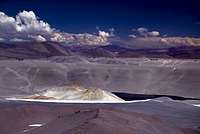
 Penitentes fields
I have asked a lot of people why it's called Bonete Chico - the Little Bonete. It would have been an ok name unless there had been a small mountain not far away called Bonete Grande - the Big Bonete. There is no doubt about which of the two mountains the small are and the big either. Chico is 6759 meters and a massive peak in all aspects. Grande is 5942 meters and a blade-like steep little thing, so there is no way a mistake of that kind has been made. If anyone has any info about this mystery; please drop me a line.
Caldera del Inca
 Caldera del Inca
This is the highest water filled crater in the world. The altitude of the water level is supposedly at 5530m according to the Argentinian tourist brochyres, but this elevation must refer to the crater rim. The water level is at least 250-300m lower than the above stated altitude. Anyway, it's a very strong contender of winning the price of: Highest Lake in the World. It's all about defining what a lake is. The crater rim is about 5km in diameter. The whole district is really in the backwaters of Argentina, but every year some intrepid travelers make to this beautiful and odd creation of nature.
External Links
 Dunes and a rock formation