
|
|
Mountain/Rock |
|---|---|
|
|
27.76929°S / 68.78132°W |
|
|
Mountaineering |
|
|
22260 ft / 6785 m |
|
|
Overview

The central parts of the massif
Pissis have five summits and three of them are almost of the same elevation. According to new SRTM-data (Shuttle Radar Topography Mission) the three summits are within three meters! Of course this means no one can guarantee which of the peaks is the highest and the generally accepted highest NW summit may well be number three. As usual mountaineers are interested in reaching the highest summit of a peak/range and when the NW summit has received a dozens of ascents the eastern twin summits has only been climbed at three occasions. Climbing the eastern summits from the south involves snow and ice climbing, which is very unusual on the Puna, where most peaks have very little snow. Both the eastern peaks were first summited by Jonson Reynoso (1985), the local legendary climber who basically climbed everything in the Puna.
The two eastern summits are sometimes referred to as "Ejército Argentino" and "U.P.A.M.E." No one I asked knew the peaks by these names. The locals simply call the Pissis peaks; Pissis (NW or main), Pissis East I and Pissis East II. As the main summit is separated by the Puna’s largest glacier, the approach to the eastern peaks is different from the one to the main peak. This is not so much of problem if coming from the north. Here you simply head off the path leading to the main peak before reaching Pissis glacier. If you arrive from the south it’s another story. Climbing the E I or E II is quite straight forward, but it’s a long way from a decent camp spot and you can count on a very long summit day. The alternative is to dig out a platform somewhere on the snowy sections. The rocky areas are close to impossible to camp in as the rocks are sharp and large.
Attempting the main peak from the south is an even longer haul on high altitude. Be very careful of choosing the right entry point into the massif, otherwise you’re in for some high altitude pass walking. Some are over 6500m and holds a lot of deep snow. Snow shoes are definitely recommended if you want to try the main summit from the south and it can be of great help also on E I and E II.
A Separate Peak?

En route to Pissis East
Pissis East may or may not be classified as a separate peak. I talked to Argentineans who were of the opinion Pissis have two summits which may not qualify due to the too little drop in between, but do qualify thanks to the distance which is roughly 2km. They also argued the peaks are not two bumps on a ridge, but "real" peaks on the far ends of a massif, separated by a large glacier. They further told me there will be a lot of measuring in the area next year (2006). One of the reasons for this is to prove Argentina have the three highest summits; Aconcagua, Pissis West/Main and Pissis East. Recent SRTM-data contradict this theory and personally I think there is no way any of the Pissis peaks are higher than Ojos del Salado. GPS-readings from Pissis (and Ojos del Salado) solidify this fact.
I, or no one else for that matter, can give you any exact figures on the altitude of the highest summits and the lowest place on the saddle, but the SRTM-sheets tell you the following: West/Main summit: 6789m East I: 6788m East II: 6786m Saddle elevation: 6480m I climbed the West/Main summit and my GPS showed: 6818m It showed 6811m on East II. The elevation given on this page is 6785m. Source: Biggar's peak list.
The conclusions we can draw from this are:
The bottom line of all this is: To be sure you have climbed the highest point in the Pissis massif you have to climb all the three highest summits and perhaps you can also claim to have climbed the third and fourth highest peaks on the continent.
This story will be continued. Possibly next year, if the measuring mission takes place.
Getting There

On the long walk in
The Pissis massif is located far away in the wilderness of the Puna. From the north, which is the normal approach, you can go by 4x4 on a rough road. Arriving from the south is much harder and it involves days of walking on high altitude in very dry surroundings. The approach itself is nothing but an expedition in itself.
From the south:
The last city of any size before the wilderness takes over is Villa Union, a pleasant sleepy place where all provisions can be bought. This is also the place for arranging a 4x4 vehicle which can take you to the target. The companies who deal with travel to the mountains are all located around the town's central square. The main tourist attraction in the area is Laguna Brava, a super-saline lake with beautiful colours. To travel there is easy to arrange, but demand for going to the mountains beyond is low. There are tours to Caldera del Inca, the highest water-filled crater in the world. The crater is located three to four days walk from the Pissis massif. The tour to Caldera del Inca is a one-day (a very long day) excursion and the vehicle usually returns to Villa Union the same day. If you want a ride to the Caldera, which is as far as any vehicle can take you anyway, you’ll need to either arrange a pick up later, or make arrangements so the arranging party stays in the area. Make sure to set a precise pickup time and exactly where that pick up will be. If you want the jeep plus personal to stay in the wilderness while you're away for up to ten days, it'll be a very expensive deal. I don't know what the going prices for a tour from Villa Union is, but from the provincial capital, La Rioja, it's about 550-700 Argentinean Pesos.
If you're of the really hardcore type and wants to arrange the whole venture by yourself hitching is the only option after Jagüe. Count on three to five cars a day, but as this is a very dry area there's a high chance they all stop for you. Be prepared to carry water for at least two days when leaving the main road at Refugio Veladero and the same rule applies on the way back.
From wherever you arrive in the area, you have to pass through Villa Union, La Rioja Province. From there a good asphalt road takes you past Castelli to Vinchina. The latter is the last real outpost of civilisation. There is an internet café, some small supermarkets, good restaurants and two hotels. You now leave the plains and enter a narrow gorge with strange-looking rock formations. The road is in an awful state for about 20 km and rivers, mud and sand has to be negotiated. When leaving the gorge, the landscape opens up again, the asphalt is back and the going is easy to Jagüe. The little settlement is a where you have to pay the park fees and register at the police station.
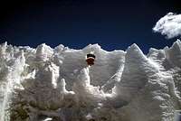
Inside the penitentes fields
Road construction, mixed with stretches of good asphalt for another 35 km to Punta del Agua, which is a gold miner’s settlement consisting of 10-12 newly built barracks. From there on; only gravel road all the way to the border of Chile. The first refugio en route is El Peñón, where you can find fresh water. A steep climb, with lots of llamas grazing on the sides, takes you to Paso Laguna Brava, a windswept pass from where you have the first close views of the peaks in the area. A small hill down to Laguna Brava and from there the road continues to the refugio on the northern end of the salty, light blue lake. You will follow the dusty road for another 11km to Refugio Veladero.
This is where you'll leave the road and head into the wilderness for real. If you're on your own here the track can be hard to find. Leave the road approximately 450-500m before the refugio. It's very hard to find in the beginning, but after a km or two it's almost like a "real" dirt road. A sandy track follows a dry riverbed in the direction of Bonete Chico, the dominating peak on your right hand side. The pyramid-shaped peak on your left is Veladero. The vehicle will take you past Bonete Chico and after 30km you’ll enter a narrow canyon. The road conditions here are partly extremely sandy, partly muddy and be prepared to work hard to get the jeep unstuck.

The rock castle
A strange castle-like rock formation marks the end of the canyon and a short climb takes you up to a small plateau, from where you can see the whole Pissis massif for the first time. The vehicle can’t go any further than to the Caldera del Inca. Start walking towards a bulky brown gravel-peak on the right hand side of the Caldera. In order to avoid too much elevation loss in the deep and steep valley ahead, walk 30 degrees right/west. The small river on the bottom of the valley is a good source of water. When up on the other side of the valley, continue in between the small peaks, and head for Bonete Grande, a blade-like peak on your left. There are many small lakes fed by glaciers after an hour’s walk and this is a good place for setting a camp. This area is of high elevation, so you have to be acclimatized for at least 5500m.
As you're shooting for Pissis East always head straight at the highest point of the right/west side of the massif. Leaving the area with the small lakes, you'll have very good views of the range from a 5600m high pass. Walk up and down over some small ridges. You better keep to your left, close to the foot of Bonete Grande in order no to loose to much elevation. After some ups and downs, you'll arrive at another 5600m pass with lots of strange and beautiful rock formations. Looking down from the pass, you'll see a quite large green lake. Walk towards the western end of it and continue up the hills on the other side of the valley. If you intend to climb Pissis Main, you should walk towards the last snowy valley in the massif. At roughly 5400m there are quite a lot of options for setting up a camp. Penitentes fields, glaciers and even small streams are good water sources here.
Note! It is not advisable to make the journey from Villa Union directly to Laguna Brava, let alone to Caldera del Inca if not acclimatized as the former is at 4300m. Count on a full day of rough travel from Villa Union
From the north:
If you don´t want to deal with the quite extreme nature of the approach on the southern side of the Pissis massif, you better shot for the northern side. You can arrange a jeep or 4x4 in Fiambalá, which is a good base for the climb. Jonson Reynoso, the legendary climber has his little office at the main square. He can help you with all the arrangements and is extremely knowledgable about the area as he has been working as a cartographer and been the official guide for many of the first ascents in the area. He is one of the few persons who has climbed more than one summit in the Pissis massif.
The ride is a pleasent 2 h on good asphalt on the main road towards Paso de San Francisco. You turn off at Pastos Largos and in front of you a rough 5 h on a bumpy path awaits you. Switchbacks up to the first pass. Here you gain almost 1500m in one go, so you better have some acclimatization. A bit up and down past beautiful very blue lakes. Lots of llamas and flamingos at the lakes. The multicolored mountain Cerro Negro de la Laguna Verde are looming over you on your right and in front of you the Pissis massif is getting closer by the minute. The path leads to a mine and after about 80km you leave the main path and head for Pissis BC. This last part is the roughest and count on almost an hour for the last 10 km. From BC it is a quite easy walk to the Pissis glacier. Put up your camp on the eastern side (you should not cross it!), which is at the foot of Pissis East.
At least one person has walked out from the Pissis massif to the main road. If that is your plan, it´s a good idea to leave waterbottles along the road. There´s water along the road, but the locals claim it is arsenic in it. The last part after the pass has good water, that´s a fact as I tried it out myself.
Red Tape

Huge penitentes fields en route
Arriving from the north: No permits needed, but the police in Fiambalá want you to register before you head for the mountains. Just a year back, anyone could drive you to Pissis BC legally, but nowadays the vehicle taking you there has to be registred by the provincial authorities in Catamarca. The jeep is driven by an authorized driver and next to him/her a "guide"/representative (something like a liaison officer for the journey to the peak!) is sitting. Of course you can flag down any vehicle, ask the driver how much he/she wants to take you to Pissis BC and go there without any risk of any serious repercussions, but the above is the 100% legal and official way.
Arriving from the south: If you want to approach the peak from the south, you can rent any vehicle, or just walk in. No restrictions or rules apply in La Rioja province. The police want you to register in Villa Union, Vincina and Jague. Free of cost. You do need to pay the entrance fee to Laguna Brava National Park in Jague Park HQ, which is located next to the road and there is a barrier over the road, so you can´t miss it.
Fees for Laguna Verde NP (southern approach) - 2005: Argentinian citizens from La Rioja province - 10 Arg. Pesos. Argentinian citizens from all other provinces - 25 Arg. Pesos. Foreigners - 50 Arg. Pesos.
If you arrive in your own car, a 10 Arg. Pesos/day fee has to be paid.
There are other fees, but these are the ones relevant for mountaineers.
When To Climb
The normal months for climbing are late November to late March. The reason for these to be the most suitable months is the higher temperatures and in general the weather is more stabile. Some propose to rather go in the colder months of April, May and even June because it's easier to find water then. Personally, I don't think it was that hard to find water and that the southern hemisphere's summer months is the preferable time to go.One thing to consider when going to a peak like Pissis is that most tour organizers don't operate in the winter, early spring or late fall. So, of you want to try this peak in the off-season, you may have to there all on your own or make a special deal with a person with a sturdy 4W-drive.
Camping

A refugio en route
Anywhere is fine!
There are no camping restrictions anywhere close to the peak. Make sure you have a strong four season tent. Preferably with storm-mats and rock pegs as the winds can be very strong in the area and the ground is sometime very hard. Nail down the tent with gravel, sand and rocks on the storm-mats.
There are some old Refugios (huts) along the main road (in between Jagüe and Barrancas Blancas). They were built in 1873 by the legendary president Sarmiento and deserve a visit, even if they are inconveniently located for mountaineering purposes. The architecture of the huts is something I've never seen before. They are all made by rocks and nothing else. Very nice "architecture".
Mountain Conditions
It's very difficult to find any info about the conditions about the actual mountain and the area close to it. The best source is to make a phone call to the customs officers in Barrancas Blancas border post. This is the only population remotely close to the peak and keep good track of the weather forecast. I have lost the phone number, but ask in the park HQ in Jagüe. They are happy to make a call for you and the same goes for the police in Vincina.You can also ask the police in Fiambalá to make a phone call to their colleagues in the border post at Las Grutas. It’s located a fair bit from the Pissis massif, but normally the weather on the plateau is about the same all over.
Water

Summit views
The Puna is one of earth's driest places and sources of water are not so easy to find. To play it safe; fill up all your reserves whenever you have the chance. Here are some important locations for water. All directions supposing you're heading north.
Additional Information
If you need local advice, contact Jonson Reynoso, the person who probably knows the most about the Pissis massif. He is the only person who have summited all the five summits. He has a little office in one of the corners of the main square in Fiambalá. Ask around, everyone in town knows him and his office is easy to recognize with big stickers saying; "Direct TV".There are very few books about Pissis, but Michael Kelsey's guide to the world's mountains gives you a good overview and useful information about the area. Ed Darack's Wild Winds has a chapter about the author's experiences on the north side when attempting the main peak.
John Biggar's peak list of all the 6000m peaks in Los Andes.
Coordinates - Southern Approach
Altitudes should be +/- 20m. Some of the waypoints are off the normal route to the mountain. We went a bit too far west because we wanted to play it safe with the water. More snow and small glaciers closer to Veladero. If you approach the peak in jeep you will not have this potential problem. The waypoints off route are in italic. A jeep can normally take you to at least the fifth entry from the bottom; "snowfield". In the summer, it may be possible to go to "Camp 12" and a little bit beyond.| · Location | Lattitude S | Longitude W | Altitude | Remark |
| Villa Union | 29*19'608 | 68*13'603 | 1140 | Decent size city |
| Vinchina | 28*44'346 | 68*13'201 | 1494 | Small town |
| 30 km | 28*39'223 | 68*19'900 | 1790 | Road better again |
| Camp 6 | 28*41'051 | 68*32'736 | 2180 | No water |
| River | 28*37'017 | 68*41'157 | 2657 | Water in creek W |
| Punta de Agua | 28*35'754 | 68*42'653 | 2754 | Settlement, water |
| Camp 7 | 28*30'388 | 68*47'152 | 3245 | Water nearby |
| El Peñón | 28*28'522 | 68*50'198 | 3599 | Water |
| Water finished | 28*26'529 | 68*50'605 | 3840 | No more water in river |
| Pass | 28*24'026 | 68*50'859 | 4381 | Nice views |
| Camp 8 | 28*20'462 | 68*51'009 | 4282 | No water |
| Turn off | 28*17'059 | 68*48'337 | 4275 | Go left, dead end right |
| Turn off | 28*15'624 | 68*49'815 | 4341 | To ref. L. Brava |
| Ref. Veladero | 28*13'451 | 68*55'187 | 4377 | Shelter and good place to hitch |
| Camp 9 | 28*10'016 | 68*53'157 | 4581 | No water |
| Arroyo Veladero | 28*07'603 | 68*53'378 | 4665 | Snow further up |
| Snowfield | 28*04'196 | 68*52'404 | 4766 | Don´t count on it |
| Creek | 27*57’363 | 68*48’348 | 5247 | Good fresh water |
| Camp12 | 27’57’052 | 68*48’203 | 5235 | Off the normal route. Water. |
| Good Camp | 27*54’193 | 68*47’271 | 5470 | Fresh water. Wind protection. |
| Camp 13 | 27*52’100 | 68*47’433 | 5534 | Past Bonete G. Water, shelter |
| Lake | 27*49’655 | 68*47’210 | 5229 | West end lowest point |
| Camp 14 | 27*48’288 | 68*46’936 | 5536 | BC for Pissis East. Water |
| Stop 1 | 27*47’136 | 68*46’849 | 6071 | Good place for break |
| Pissis East | 27*46’137 | 68*46’800 | 6811/6785 | The Summit! |
The summits of Pissis
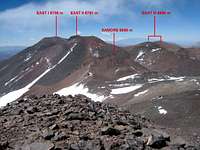 Eastern summits | Western summits | 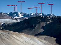 Seen from the south |

Summits of Pissis