
|
|
Mountain/Rock |
|---|---|
|
|
27.19598°S / 68.56106°W |
|
|
Mountaineering |
|
|
21844 ft / 6658 m |
|
|
Overview
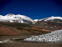 The colors of the Puna and Cazadero
The mountain is the 9'th highest in South America and is located on the Puna, a barren high plateau in Argentina and Chile. The old name of the peak is Cazadero, but is more well known as Walter Penck, named after the German geologist who first visited the peak in 1913. The mountain was summited for the first time by a Chilean/Japanese expedition in 1970. K. Takeshita, Sergio Kunstmann and Pedro Rosende were the summiteers.
It's a volcano and the final little crux en route is the boulder clustered sides of the crater. It has many small rocky summits and the only way to determine which it the highest is try and failure until you find a steep pile of rocks with a little note book, which serves as a summit log.
Even though the peak is an easy climb technically, it's a demanding undertaking to reach its summit. High altitude, the rough climate of the Puna and the peak's isolation far into the wilderness, makes the climb an adventure in all aspects.
Getting There
To Fiambalá and further to the trailheadLa Rioja and Catamarca are the two major cities in the area and both are the capitals of the provinces with the same names. When in any of those quite large cities; look for local transport towards Tinogasta and further to Fiambalá. Most buses only goes to the former and you may have to change there to get to the latter, which is the perfect base for Ojos del Salado. If you arrive late in Tinogasta and there are no more buses, shared taxis runs until very late and even if you have to rent one for yourself, it's inexpensive at USD$10 for the 50-55km ride.
All necessary basic food items are to be found in Fiambalá and one of the persons who knows the area best of all, Mr Reynoso is operating from here. 4x4 vehicles can be rented with a day's notice and will take you for a two hour ride on good asphalt to Refugio Cazadero Grande, a hut along the main road. This is a good place to spend a day, if not acclimatized. The 4x4 can take you another 10-12km on a bumpy path until you hit the Cazadero Grande River Canyon. There is a little primitive refugio close to the river, almost at the entrance of the canyon.
 Walking towards Cazadero
Most expeditions have arranged with mulas to take over from here and extremely few have done this trek towards the peak unsupported. For the first day there are plenty of water to Aguas Calientes, the source of the river, which is a spring with lots of warm, almost hot water coming straight out of the ground. Good camp spots all along the way and plenty of curious vicunas. It's a 5-10 hour walk from Cazadero Grande to Aguas Calientes.
From here on you have to choices. The mulateros will probably try to convince you it's better and shorter to go to Agua Vicuñas (which it's not).
From the trailhead directly towards Cazadero
Leave Aguas Calientes straight towards the mountains in a wide valley. After some minutes you'll see Nacimiento on your left. Continue into a little canyon and keep on walking on the sandy path. When you arrive at a little "path-fork", you'll see a grey rock formation on the right hand trail. It's about a hundred meters up valley. On your left you see another canyon, with a path much less used. Go left. Continue in this dry valley upwards. After many hours walk, the path gets steeper. Walk over a flat pass. On the other side a wide valley welcomes you. At the end of it, on the left hand side you'll see Volcan Santiago Olmedo - a huge red cone of a peak. Looming behind it is Cazadero. The wide valley is at about 5300m and probably the first source of water.
Aim at the far end of the valley and a small glacier/penitentes field some kilometers away. It's a steep walk up the hill to the pass there and keep right at the glacier. Further to the left it may looks easier, but there are hidden hills behind the ridge. After you've walked around, or over the penitentes field, head down to a large bowl-like place. There are plenty of melt-off from small glacier and penitentes fields here and it serves fine for a base camp. The last pass is high, almost 5700m and the camp is at 5600, so be very sure to be acclimatized! No fun walking back down those hills.
From the trailhead via Arenal to Cazadero
Leave Aguas Calientes straight towards the mountains in a wide valley. After some minutes you'll see Nacimiento on your left. Continue into a little canyon and keep on walking on the sandy path. When you arrive at a little "path-fork", you'll see a grey rock formation on the right hand trail. It's about a hundred meters up valley. On your left you see another canyon, with a path much less used. Go right.
The walk to Agua Vicuñas is a dry and windy walk over wide plains and in sandy valleys. Nacimiento and Incahuasi dominates the views. Agua Vicuña, despite the name, is usually a camping place without water, but the camping options are great. The going gets steeper and tougher on looser scree and the rough path finally takes you to a pass called Portezuelo Negro at 5500m. There are plenty of water on the north side of the pass and a beautiful little lagoon can be seen to the right.
Hold to your left on the most of the time visible path. You now have clear views of Ojos del Salado and soon Cazadero. When you see the latter aim for it and walk on until you find a suitable base camp.
Red Tape
None!For your own safety, you may want to register with the tourist police in Fiambalá. Look for a building marked Seguridad Turistica on the main square. Free of charge.
Camping
 Cazadero 6658m, the 9'th highest peak outside Asia.
There is choice but camping in the area, allthough there ares some alternatives just in the beginning of the walk in. There's a refugio at Cazadero Grande, from where you start the approach, which is located at the main road (Fiambalá - Paso de San Francisco). There's another primitive hut half a day's walk along the trail, but at that point you're still days away from the base camp of Cazadero.
Camp spots are very easy to find in the open terrain, but water can be scarce. Pay a lot of attention to how you anchor your tent. Fierce and sudden gusts of wind are common and the force of both katabatic and Viento Blancos (white wind) can be extremely strong.
When to climb and conditions
The normal months to climb in this area is from December to March. This is the warmest period. On the other hand, rain and thunderstorms are common and it's also the driest time of the year. Some prefer to go later as it's easier to find water then.As the Puna is one of the driest areas of planet earth, too much snow is rarely a problem. When I climbed the peak in February, 2006 there was a lot of snow on the higher parts of the peak. The hard weather the prior week had also succeded to dump a lot of verglass on the rocks on higher elevation. Not much to do about that, but don't take for granted Cazadero is an easy rock scramble.
A good weather site is Meteoexplorations.
Organizing the climb - Fiambalá
As for all the other peaks on the Puna, Jonson Reynoso is the person to contact. He's located in Fiambalá and knows the region as the back of his hand. The services he can offer include transport, mulas, info and he has some gear for rent.If arriving in Fiambalá without any prior contact with him, you'll find him on one of the corners of the main square in a building marked Seguridad Turistica - tourist police. This is also the place where you register before haeding for the mountains.
Fiambalá has a few good restaurants. Ohlala is one of them. It's located on the main square and is run by a french girl. Excellent food. Another option is the flashier and more expensive Pizzeria Roma a block away from the square. There are bakeries, some small supermarkets and food shops. Two farmacies, two internet joints and some highly recommended hot springs makes the place a perfect base for the climbing adventure on the Puna.
The town is also famous for good vines and archeology.
The place to stay for a mountaineer is of course Hostel Campo Base. Located a two minute walk from the main square and ran by Jonson's daughter Ruth, who also is an alpinist with good knowledge about the area. The location is quiet and one can use the kitchen. A great base.
Maps & books
GPS - Coordinates
All the below coordinates are GPS-coordinates. If you for some reason want to convert them to any other system; check here.| Place | Lat | Long | Altitude | Remark |
| Cazadero Grande | 27*25'190 | 68*07'778 | 3482 | Refugio |
| 4wstop | 27*22’966 | 68*08’353 | 3490 | Main road |
| 4wstart | 27*22’226 | 68*13’756 | 3699 | Ravine start/finish |
| Chorro | 27*20’428 | 68*16’476 | 3829 | Water |
| Camp | 27*19’785 | 68*20’190 | 4023 | Water |
| Aguas Calientes | 27*18’018 | 68*21’093 | 4180 | Water |
| Agua Vicuñas | 27*11’788 | 68*25’791 | 4965 | No water |
| Portezuelo Negro | 27*09’910 | 68*27’550 | 5553 | Pass, water nearby |
| Platforms+shelters | 27*09’555 | 68*28'256 | 5537 | Camp&water |
| Arenal | 27*09'014 | 68*29'774 | 5501 | Camp&water |
No coordinates from Arenal to the foot of Cazadero. Sorry.