Summary
My friends, Brendan Oldham, Brian Senjam and I climbed Gannett Peak via the North Face route, Aug 22, 2006. Our approach was via the old Glacier Trail, 23 miles long, which we hiked in and out over a seven day period (Aug 19-25). The trail starts at about 8,200', goes over two passes, at about 10,900' and 10,400', drops back down to 9,600 along Dinwoody Creek, then ascends to Gannett's summit, at 13,890'. The weather was near perfect, with sunny, but not hot, days, and coolish nights, though our summit day had a brief afternoon storm. This is a classic alpine trip, with a long, rugged approach passing beautiful mountain lakes and streams, terminating in the sweeping snowfields and jagged peaks on the roof of Wyoming. To our delight, we encountered almost no mosquitoes, which can be prolific earlier in the season.
The Hike In: Day One
There are basically two options for approaching Gannett Peak from the east: the Glacier Trail, at 23 miles, or the Cold Springs trail, at about 10 miles. The latter, however, crosses the Wind River Indian Reservation, and will cost you several hundred dollars. (The cost seems to vary; see related article at
Gannett Peak: The Easy Way). Being cheap climbers who wanted the "full flavor" mountaineering experience, we opted for the longer and cheaper option, taking Glacier Trail in from the northeast. We used Joe Kelsey's book, Guide to the Wind Rivers, to gain knowledge about our options and routes. However, we found the book while good for getting us started, was rather deficient in information on the final approach directions and technical route descriptions for Gannett. (This is my reason for this detailed posting for others' benefit, because we considered this an outstanding route.)
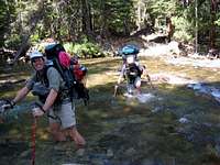
![Torrey Creek ford]() Brendan and Rick fording Torrey Creek
Brendan and Rick fording Torrey CreekTo reach Trail Lake trail, we traveled north on 287 through Lander, where about four miles south of Dubois, there is the USFS dirt road into Whiskey Basin/Torrey Lake. About eight miles in, the road terminates at the Trail Lake parking lot. Just before getting there though, a USFS ranger stopped us to say that the new Glacier Trail was closed due to a small forest fire they were letting burn out. We had no choice but to take the
old Glacier Trail, which, as we were to find out,
has no water for the first nine miles! We left the parking lot about 1 pm, following a line of large boulders marking the boundary of the parking lot, past the packers horse trailers, to ford Torrey Creek.
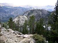
Two thousand eight hundred feet higher, and about five hours later, I wearily trailed Brendan and Brian as we approached the pass that leads down into Burro Flats. The wind along this barren ridge seemed to suck the moisture right out of you; I would take a drink and be thirsty moments later. Everyone ran out of water, even with three liter Camelbaks.
![Burro Flats Pass]() Burro Flats Pass
Burro Flats Pass We'd hoped to reach Double Lake, 10 miles in, the first day, but were happy to dump our packs and camp beside a satellite pond of Upper Phillips Lake, at 8:45pm, dehydrated and exhausted from our first day of brutal backpacking.
The Hike In: Day Two
The next day, we did
not rise early, and decided to cache as much gear as we could at Double Lake, to lighten our packs on the way in. We hung a last night's meal, an extra stove and fuel, and I left my hiking boots, deciding to hike in my mountaineering boots rather than carry the suckers.
![Double Lake]() Double Lake
Double Lake
From Double Lake, the trail goes up a bit to pass close by Star Lake, then high above Honeymoon Lake, before descending steeply, via many rocky, horsehoof-beated switchbacks, to Dinwoody Creek.
![Honeymoon Lake]() Honeymoon Lake
Honeymoon Lake
The rest of the trail on the approach is mercifully flat or rolling, as it follows the Dinwoody drainage up valley. This was another long day though, as we tried to push as far as could to obtain a rest day prior to climbing. As I trudged along Dinwoody Creek though, getting a little lost in the Big Sandy flats, climbing Gannett was not on my mind. What I was wondering about was where we would camp that night, and why hadn't I reached it by now? Finally, I saw my friends packs at the Ink Wells trail junction, a picturesque camp site, at about 7:30 pm, another long, pack-humping day.
But from here, we could just spot Gannett Peak for the first time, an awe-inspiring sight...
![Gannett from Ink Wells trail]() First glimpse of Gannett, end of day two
First glimpse of Gannett, end of day twoDay 3: Half Hike, Half Reconnaissance
By the third day, we were just a few miles from the confluence of Dinwoody Creek and Gannett Creek, which we knew was where we were going to camp. We had learned this from having met a family also camping at the Ink Wells junction, a grandfather, father and two daughters. The grandfather had climbed Gannett via the North Face route some 25 years ago, and a source of much information. He advised us to approach via Gannett Creek, and traverse the snowfields from the north, and to then descend via the rock rib that bordered the (climber's) left side of the North Face route. For that was the way, he said, that he had descended from Gannett's summit long ago. His story was enlivened by his relating that he'd almost died on the climb, having slipped on the upper ice face, climbing alone with a single ice axe, and slid down the entire upper ice section, stopping only when he the rock band below it, luckily not injuring himself when he struck a ledge. Amazingly, he successfully then completed the climb; I suppose he felt he had no other choice.
So this was an easy hiking day, much more relaxed in pace and duration than the previous two, graced by the views of our objective as we drew closer.
![Dinwoody Creek]() Along Dinwoody Creek
Along Dinwoody Creek
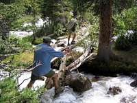
By early afternoon, we had reached the confluence of Gannett Creek. We made camp in one of the few flat spots among the tall evergreens, rested a bit then set off to explore Gannett Creek and the approach we would take for the climb. It was fortuitous to have done so, as the trail up Gannett Creek was faint and difficult to find. It involved crossing small log bridges, some studier than others, four times, and you didn't want to fall on any of them; I found my hiking poles to be essential in these maneuvers, and did not relish the thought of crossing them in the pre-dawn darkness tomorrow.
![Gannet Creek crossing]() Brian crossing Gannett Creek
Brian crossing Gannett CreekDay 4: Approach to The Summit
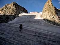
We awoke at 3 and were on the trail by 3:45 am. Within an hour, we had navigated our way up Gannett Creek, over the four flimsy log crossings, and were dealing with finding a way through a band of rocky ledges at the creek headwaters below the glacier. Not having explored a way through this section during our reconnaissance the previous day, we got cliffed out a couple of times, costing us about an hour. Eventually we broke through this section to the glacier proper, where we easily walked up its surface, as the impregnated grit and gravel provided quite sure footing.
![On Gannett Glacier]() On Gannett Glacier
On Gannett Glacier
As we cleared the gravel-covered section in the waning dawn, we decided to head straight up through a steep section between two rock pinnacles that seemed to guard the approach like a giant gate. We could see this choice would be steeper, but it did not appear to be crevassed; at this point we donned our crampons, but did not rope up.
![The Gate to Gannett]() Approaching the "Gate" below Gannett
Approaching the "Gate" below Gannett
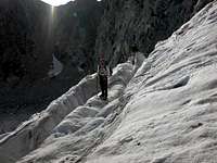
This turned out to be a trick of the morning light and our angle of view, for it did contain some large crevasses we had to find our way through, with one section that required a short, exposed catwalk between two yawning gaps.
![Through The Maze]() Through the crevassed maze
Through the crevassed maze
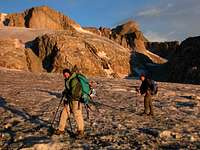
Once through the heavily creavassed "Gate" (my own name, but seems to fit), it was an easy stroll over to base of the North Face. The route was obvious: we needed to pass the huge bergschrund on the right, then go up. Here we dropped our poles, roped up, got the ice gear and started swinging our axes. We decided to simul-climb as a party of three, as the ice was not that steep or technically difficult, and would be faster than belayed pitches.
Summit Day 4: The North Face
![North Face Route, Gannett Peak]() North Face of Gannett
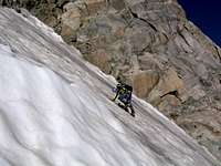
North Face of Gannett The north face route starts off the Gannett Glacier, steepening into 40 degree ice, at most; the photo shows our route around the bergscrund. The condition of the route was still quite good at 9am when we started up; a thin layer of soft snow covered hard alpine ice. We used ice screws for protection on a running belay all the way up. Brendan started up first, myself in the middle, and Brian in the rear.
![Brendan leading]() Brendan leading off on the North Face
Brendan leading off on the North Face About two-thirds the way up the face, Brendan used his last two ice screws at a small snow ledge. From here, Brian came up, and armed with the screws he had taken out, continued on up and to the right. (Yes, I had it easy on this section; but I contributed later!)
![Rick on the North Face]() Rick on the North Face
Rick on the North Face We had collectively decided to head for the obvious snow saddle in the ridge above, rather than head left through a small ice tongue in the rock band. Climbing the upper ice cap seemed unnecessary, as by this time in the year the rock ledges leading to the summit from the snow saddle looked easier.
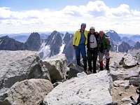
From the snow saddle, we fourth classed up the easy ledges towards the summit within about thirty minutes; a short stroll along the ridge above brought us to the summit. Exhilerated, we enjoyed the views alone, no one else in sight, on this glorious day on the roof of Wyoming!
![Summit shot]() Gannett summit shot
Gannett summit shotSummit Day 4: The Descent
Of course, getting up is just half the climb. To get down, we'd decided to trust the information from our visitor the night before, and descend the rock rib towards the West Sentinel. We started down about 12:15pm, guided only by a sense of direction based on visible landmarks well beyond the base of the peak -- i.e., very general -- as the ridge dropped so steeply you could not see the base. After 30 minutes of hiking, the terrain shifted to exposed fourth class, requiring careful route finding through steep, sharp ledges, with frequent loose rock; needless to say, a fall would have been a serious matter. We remembered the advice of our old guide, and tried to stay out of the central gullies, keeping to the left (facing down).
The sky had been getting more cloudy during our descent, and around 2pm began to send down intermittant graupel (small, hail-like snowballs), gradually dampening the rock, and our outlook. Once we heard distant thunder, and tried to quicken our pace. By around 3 pm we were nearing the glacier enough to consider rappelling, as we seemed to have no clear descent route on the rock. Heading sharply left, we craned our necks out as far as we dared, trying to spy a clean rappel down, picked the best looking spot, and sacrificed three old-but-good pieces and two slings for the anchor, and went for it.
I went down first, with the ropes thankfully just reaching the snow. My relief was short-lived, as the "safe" snow was actually a 30 degree slope of pretty much solid ice, that about 30 feet down emptied into the hugh berschrund that we'd had to avoid on the way up. Looking down at it as I neared the end of the rappel, I felt kind of like a small minnow must feel like moments before getting swallowed by a huge jaws of a shark. Still on rappel, I put in two good ice screws for a hanging belay, and set about the dicey process of getting my pack off and my crampons on. As Brendan and Brian rapped down, I directed them to stop shortly above me, as there was no room at the hanging belay stance on the ice beyond me, and they put in a doubtful rock anchor in the shattered rock about them. We held our breath as we pulled the ropes down the sketchy face; thankfully it did not catch on anything. Soon I was belaying Brendan as he led out the sharp end on the ice once more, heading up and right above the bergscrund, heading for what we hoped was a bridge across the end of that gaping crevasse. Before Brendan made the final move over it, he placed a solid picket, warning us that it should be an easy move, but that a fall would be "a serious matter!" (in other words, into the 'schrund!)
![Rick above the bergschrund]() Rick above bergscrund
Rick above bergscrund
But soon we had all made the move, onto easier snow, and soon back to where we'd left our poles on the glacier that morning; it was now approaching 4 pm, and still had our hike back. We refilled our water bottles from the abundant streams running over the glacier surface. Though my partners treated their water here, I drank directly from the flowing waters, trusting it to not be contaminated (and never got sick). Picking our way back, we headed for the shortest route off the glacier, heading more directly for the Gannett Creek headwaters, marveling in the alpine landscape. Long was the route still to go, scrambling along the edges of the churning creek, then down the steep, forested embankments, finally reversing the four skinny log crossings, getting back to camp around 8:30 pm, making for about a 14.5 hour day.
Days 5 and 6: The Hike Out
The hike out was much more relaxed; we rose late, stopped early. So on day five, we made it back to the sandy beach on the eastern rim of the Big Meadows, along Dinwoody Creek. Here we were able to finally relax a bit, bathing by the creek, and tried to enjoy our sandy campsite as colorful sunset ended the day.
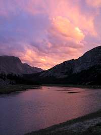
![Sandy beach sunset]() Sunset at sandy beach at Big Meadows, Aug 23, 2006.
Sunset at sandy beach at Big Meadows, Aug 23, 2006.
The site was a mistake, as it turned out, as a wind storm kicked up during the night. Though it never rained, our anxiety was increased from the smell of a distant forest fire, and our sleep marred by the lashing tent and fine sand that blew through the mosquito netting; camping a little further in the trees would have been the wiser choice.
The next day, covering the steep hike up and over the pass that goes by Honeymoon Lake, we stopped for our last camp at Double Lake, and enjoyed the beauty and solitude with the last of our rations from our cache that we'd left. Having the time to just sit on the rocks beside Double Lake and relax felt luxurious; it was so warm I was enticed to jump into the tempting waters -- for about five seconds! It was indeed icy cold.
![Rick takes plunge!]() Rick in Double Lake, Aug 24, 2006
Rick in Double Lake, Aug 24, 2006
The final day and hike out was uneventful; we were all eager to get the hike over with, no longer as enthralled by the scenery as on the way in. We did have some excitement when we spotted a moose near the trail on the hike up from Double Lake. We regrouped to filter water at the last creek we knew we would see for the rest of the hike out.
![The last watering hole]() Last watering hole on way back on Glacier Trail, Aug 24, 2006.
Last watering hole on way back on Glacier Trail, Aug 24, 2006.
The rest of the hike out was uneventful. Brian and Brendan plowed on ahead, hiking from Burro Flats Pass down to the trailhead in something like three hours. I was considerably slower, doing it in about five hours, which was uneventful except for an afternoon thundershower that moved in just after I cleared the exposed meadows on the final switchbacks down, striking the ridge above me with one explosive thunderclap. It was fitting grand farewell to a powerfully moving trip. I hope you benefit from this information and get to make the trip yourself!


Comments
Post a Comment