
Bill Reed - May 21, 2009 9:25 pm - Voted 10/10
Loved every word of it.......and every photograph. Makes me want to get up there in the spring and do it in the snow!! Had a similar experience coming out - planned on taking two days and ended up burning it out in one. When we tried to move our reservations up a night, the desk clerk at the motel in Pinedale accused us of "hiking out for burgers and beer." He was absolutely right!!
Good call on turning around, another day will come.

goofball - May 21, 2009 10:54 pm - Voted 10/10
very cool.great pics and story ! sounds like it was a ton of fun. i, for one, am a big fan of experiencing weather. never been in a snow storm like that, but a few thunderstorms from hell.

Garfimi - May 22, 2009 12:39 am - Voted 10/10
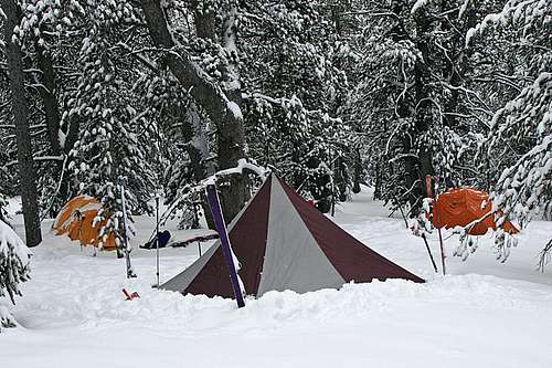
Stunningphotos, great trip report. Once again Marauders your photo's are stunning. One question: How did your B D Megalite hold up against the wind?
Garfimi
marauders - May 22, 2009 3:01 am - Hasn't voted
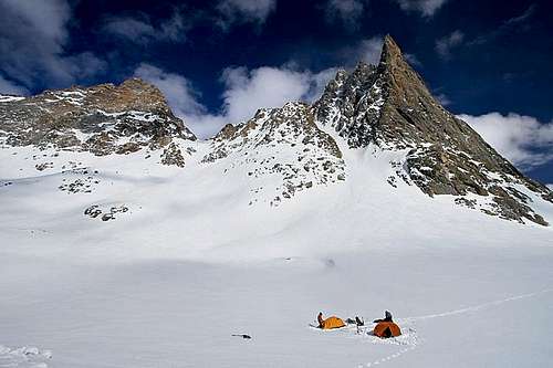
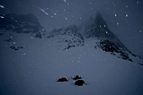
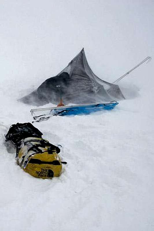
Re: StunningYa know it did remarkably well. The Megalite was our kitchen tent, so we would drop it at night and let the snow build up on top. We had stronger 4-season tents for our man caves.

TJ311 - May 22, 2009 2:07 pm - Hasn't voted
Your Trip Reportwas GREAT!! Sounds like quite an adventure. Awesome pictures too!

BCJ - May 28, 2009 12:51 pm - Voted 10/10
Fantastic report!Loved reading this one. Neat to see the area in its winter form.

46and2 - May 28, 2009 10:55 pm - Voted 10/10
As usual...Your pics are amazing. Great colors and contrast... damn perfect exposure! I am headed up to the Winds in last Aug (East Fork) but this makes me want to go now! Did you get any decent skiing in down from Bonney?

mauri pelto - May 31, 2009 7:05 am - Voted 10/10
journey not summitWhat an awesome journey you visually chronicled to base camp. Summit not achieved disappointing now, but two years from now looking back at the pictures, maybe not.

merrill - May 31, 2009 4:15 pm - Voted 10/10
Awesome reportThat brings back good memories of a summer trip. It looks amazing in the snow. We too decided to book it to the trailand went from Bonney's pass to the car in one day and barely made it for burgers.
Merrill

tannerpuma15 - Jun 1, 2009 12:52 am - Voted 10/10
AWE inspiring viewsGreat trip report and wonderful pictures...the only good part about not summiting is understanding that the mountain will be there next year. Salud and good luck next year!

SFMountaineer - Jun 1, 2009 2:07 am - Voted 10/10
A model trip reportJust the right amount of information in the text with the rest of the story told by excellent pictures. Thi is the way to do it folks.

PellucidWombat - Jun 1, 2009 2:48 am - Voted 10/10
Great experienceHey Marauders,
Thanks for the excellent trip report/photo journal! I've been wanting to do an outing like that in the mountains for years. Frankly, that sort of trip is probably the best training you can do for climbing a larger mountain like Denali.
Also, I'm glad to hear your Mega-Light held up. I was wary of getting one, but since the Mega-Mid is no longer available, I had no choice!
- Mark
marauders - Jun 1, 2009 10:59 am - Hasn't voted
Re: Great experienceDuring the storm days we had, I was bored stiff and I thought about your TR from Alaska when you had to spend each day trying to burn time. You've got some serious mental endurance. I could barely last a few days!
PellucidWombat - Jun 1, 2009 5:36 pm - Voted 10/10
Re: Great experiencedid you try digging any snow holes? It's amazing therapeutic :-)

wyopeakMike - Jun 1, 2009 8:38 pm - Voted 10/10
awesome photosI have only been there in the summer, and I don't see too many winter or spring views of the area. It was great to see Island and Seneca lakes frozen over. What a different place with all of the snow, and no backpackers and horses around. I enjoyed every shot you posted. The summit will still be there for next time.
marauders - Jun 2, 2009 1:59 pm - Hasn't voted
Re: awesome photosYeah, it definitely had a great "remote" feeling. We didn't see another soul the whole time. The peace and quiet was nice.

littlefrantz - Jun 2, 2009 8:40 pm - Hasn't voted
WoW!Beast of a trip!

96avs01 - Jun 2, 2009 9:36 pm - Voted 10/10
Good Stuff!Applaud your early season efforts! Plans for a return trip/ski descent? Cheers
marauders - Jun 3, 2009 12:49 pm - Hasn't voted
Re: Good Stuff!Oh, definitely. This first attempt gave us better insight into the route. We could do it lighter and faster, and of course catch better weather.

Moogie737 - Jun 4, 2009 2:22 pm - Voted 10/10
To even attempt it took moxie!Having done Gannett last summer, I was blown away by your idea to attempt it with winter conditions. Nice effort, however, and I know you would have made it had old man weather not been so cantankerous. You made the right decisions. Nice going. Also, captivating pictures. Looked a little bit different than it did last August! :)
Comments
Post a Comment