Intro
Slideshow
Back in 1997, I began my quest for the state highpoints by visiting Clingman’s Dome, TN and Mt Mitchell, NC during my honeymoon with my wife. Fast forward 11 years later and the quest is down to 3 remaining big boys and I figured it was time to give mighty Gannett a try. John “Lists of John” Kirk and Dwight Sunwall were up for the challenge and dates were set.
Gannett resides in the remote Wind River range in west central Wyoming, which sports the largest amount of glaciers in the U.S. Rockies. Gannett is considered to be one of the easier 13ers in the range, but many of these beasts are 5th class climbs with considerable crevasse dangers. The Gannett Peak quad alone sports 32 ranked 13ers! Gannett is the most remote of all of the state highpoints including Denali as the shortest free route is a 40 mile round trip backpack involving glacier travel, stream crossings, mosquito tolerance, scrambling, a couloir climb, and an exciting finish along the exposed summit ridge. Most parties choose to approach the peak over two days. We went with the Titcomb Basin approach from the south even though you loose 1200 feet of elevation gain after ascending Bonney Pass. We decided to pack in as far as we could the first day and use the second day to possibly hit easier nearby 13ers Jackson and Fremont. If we were successful on Gannett day 3, we would hit whatever was reasonable on day 4. Little did we know what the Winds had in store for us! There are no gimmies in the Winds!
Day 1-Pack In-Elkhart Park TH (9370') to camp above Island Lake (10580')
Sat, July 12
12.8 miles, 2600’ gain
8 hours
After a short night of sleep at the Econolodge in Rock Springs, we set out for Pinedale and ate a “last breakfast” at a nice café there. We made our way up to the Elkhart Park trailhead and got our gear ready for the long day ahead. I’m not a fan of backpacking and don’t do a very good job at keeping the weight down, but I was pleased that my pack weighed in at only 45 pounds including 2 quarts of water for 5 days in the mountains carrying glacier gear. Dwight’s weighed the same, but John’s was 20 pounds heavier mainly due to all the food he brought! I ended up needing some of that food at trip’s end as I underestimated how much I would eat. John is a very fast hiker and is hard to keep in site, so the more weight he was carrying the better!
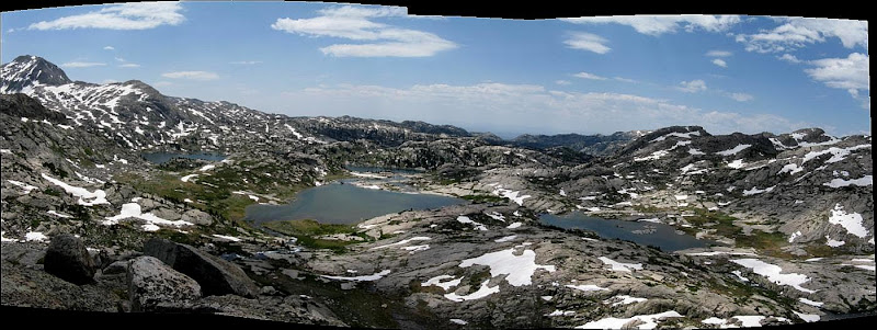
Off we went at 9am, unsure how far we would get the first day. The route is a series of trails that you follow to Titcomb Basin. The Pole Creek trail is the initial trail that you set out from at Elkhart Park that gradually climbs to Miller Park and Photographer’s Point, a popular dayhike destination for folks who want to see the mighty Winds from a distance.
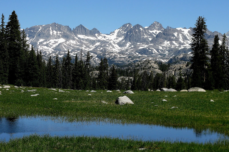
John set a fast pace while Dwight and I settled in to our own pace. I would be the slow man most of the time for this strong team, but I knew I could go the distance. We took a break at Photographer’s Point and scrambled up to the true summit of this named but unranked point. The views to the north were exciting to say the least as many jagged peaks dotted the skyline.
The frustrating part about the approach is there are many ups and downs to the tune of around 1400’ as there are many glacial carved valleys filled with beautiful lakes. From Photographer’s Point, the rollercoaster ride begins as you pass by lake after lake. The route connects with the Seneca Lakes trail, which wraps around the west side of the Seneca Lakes. On the approach, the trail was submerged at the edge of the lake in a couple spots. Dwight and I just plowed on through the 2 feet deep water while John scrambled up the slope to keep his boots dry. I figured we were near the end of the day, so I wasn’t too concerned with wet boots. We took a much needed lunch break at the n.w. corner of the lower Seneca Lake and John set off to tag ranked Point 10780C while Dwight and I ate and fought off the mosquitoes.
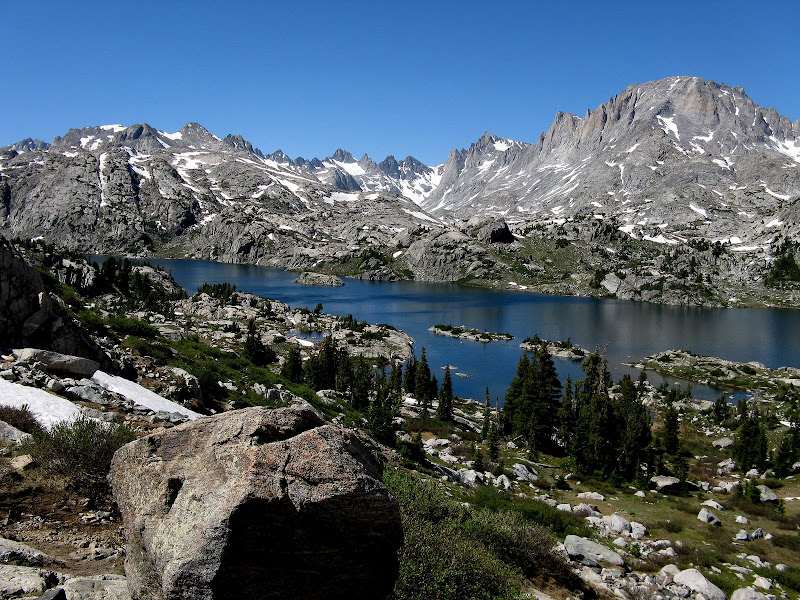
Beyond Little Seneca Lake, we linked up with the Indian Pass trail which took us to panoramic Island Lake.
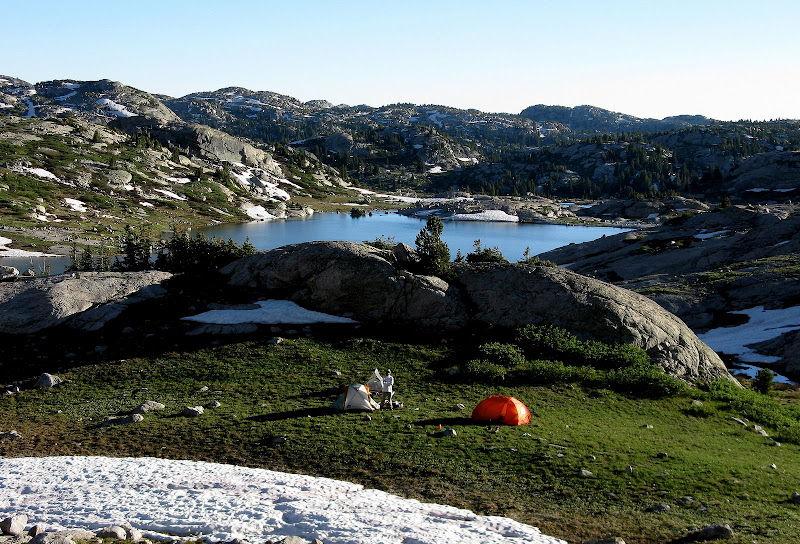
The mosquitoes for most of the day weren’t too bad as long as you kept moving, but they would get worse as our trip progressed. We were all starting to feel the effects of the long day and decided to setup a base camp on the north side of Island Lake just north of Lake 10467 at 10580’. We made it to camp around 5pm and cooked some dinner before planning a climb of class 2 13er Jackson Peak as our “warmup” climb for Gannett.
Day 2- Jackson Peak (13517') & Pt 11460E
Sun, July 13
9.5 miles RT, 4000’ gain
12 hours
And This Is Supposed to Be a Warmup?
We had high hopes for the day of doing both Jackson and Fremont. We knew the ridge between them was impossible, but we thought a low traverse back down to Indian Basin after a quick climb of Jackson would be possible. That would turn out to be a pipe dream. We left camp at 6:30am and caught the Indian Pass trail just south of camp. The trail winds its way up to enchanting Indian Basin, a land of still frozen lakes and impressive peaks.
None of us took the time to read the route description for Jackson even though I bought a Wind River guidebook and we paid the price. For some reason, I was almost certain we were to follow the trail all the way to Indian Pass and follow the s.e. ridge to the summit. We lost the trail long before we reached the pass, so boulder hopping ensued. The closer we got to the pass, the gnarlier that s.e. ridge looked! We decided to give it a shot and see what happened. We found a loose class 3 gully that we hoped would take us up to the ridgecrest without a lot of difficulty, but we soon found out that we couldn’t get to the ridge without doing some exposed scrambling on loose choss. We backed off and tried traversing on the south side on broken ledges. I climbed up to a notch and didn’t like what I saw as it was likely exposed class 4 or harder, so we boulder hopped all the way back to the pass to see what the north side looked like. The north side was steep snow and likely part of Bull Lake Glacier, so we went for a lower line on easier terrain in search of a magical gully to the ridge.
We finally found a loose gully that it looked like would go to the ridge, but there was snow near the top. There was enough rock on the right side of the snow that I was able to squeeze past without breaking out the crampons while John and Dwight too a higher line on ledges to enter the gully above the snow. We finally made it to the ridge at a point where it mellows out to gentle slopes on snow to the summit.
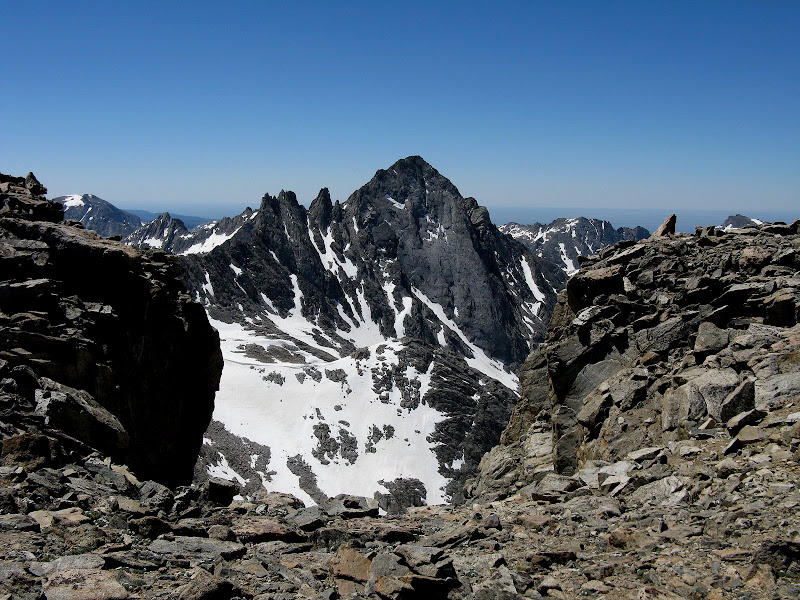
The remaining 800’ went fairly quick and we topped out at 1pm. The ridge over to Fremont made the Blanca to Little Bear traverse in CO look easy. I’m sure somebody has done that ridge before, but it sure looked insane! We enjoyed our airy perch on Jackson and got our first view of Gannett way off to the north.
The gully we ascended had a cairn at the top, so maybe this was the standard route. We descended the snow with crampons, then slowly made our way down the annoying, loose choss down to the valley. Fremont was out of the question today as we were out of time and were beat. For a consolation prize, we hit ranked Pt 11460E on the way back to camp, which required only an additional 500 feet of vertical. We didn’t make it back to camp until 6:30, so we quickly cooked our meals and headed for bed as we would soon be rising for summit day for Gannett.
Day 3-Gannett Summit Day
Gannett Pk (13804’)
Mon, July 14
Highest point in the state of Wyoming
14.4 miles RT, 5500’ gain
19.25 hrs
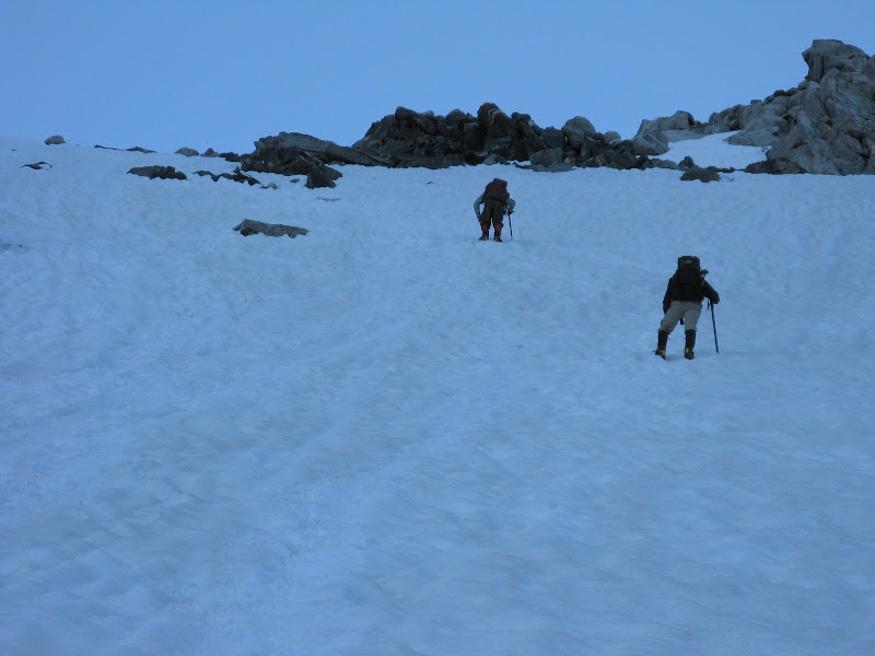
The day had finally come. The weather had been superb so far the first two days and the last forecast we saw called for a 20% chance of storms this day. Most folks either camp at Upper Titcomb Lake or all the way on Bonney Pass before summit day, so we were taking a risk with the weather starting just above Island Lake. After a short night sleep in which I slept fairly well for once, we set out at 3am catching the Titcomb Basin trail just west of our camp. We lost the trail briefly a few times amidst patches of snow, but once we got to the lower Titcomb Lake it was easy to follow on the east side of the lake. It’s amazing how much snow is still here this late into the summer. We slopped our way through up the muddy trail, but the snow was mostly firm with minimal postholing.
I made it a point to conserve my energy early on as I knew this was going to be a long day. Little did we know how long it would be! We made great time up the basin passing only one tent from a group that looked liked they might had made a summit bid the day before. We followed their tracks to the base of the snow climb to Bonney Pass. We donned crampons, axes, and helmets here for this moderate climb that we estimated to be no steeper than 35 degrees, but it was a long grunt of some 1200’ to the pass.
The snow gives way to rock for the last 100’ or so and I topped out at around 7:40am. Here we got our first up close view of Gannett, but we had a lot of work ahead of us because now we were about to give up 1200’ of vertical that we had just gained.

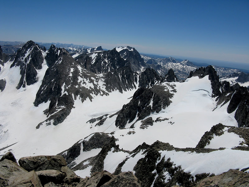
This is the tradeoff for approaching from Titcomb Basin. The north side of Bonney Pass was dry and there was a decent trail to follow. We descended on snow about halfway down and roped up where the glacier starts at around 12200’. Dinwoody Glacier was in great shape and there was no evidence of crevasses, but we played it safe and roped up. The day was quickly heating up and we were roasting as we dropped down to 11600’ before traversing over to Gooseneck Ridge.

Here we decided to ascend the ridge on rock, although most parties choose to cross the ridge and ascend the edge of Gooseneck Glacier. The ridge is mostly enjoyable class 3 scrambling with some boulder hopping. There might have been a move or two of class 4.

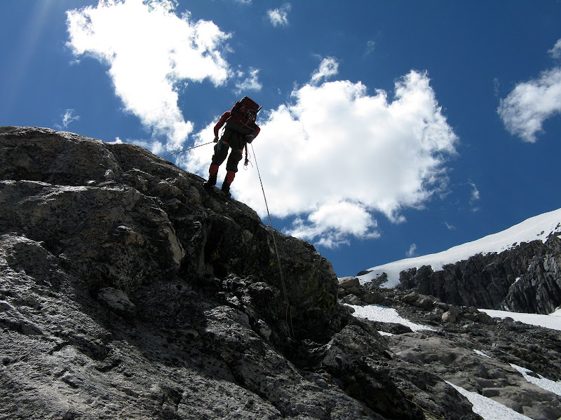
There was one tricky part that still held some snow and ice up a class 3 when dry corner that I got my ice axe out for. Dwight picked a steeper but drier line to the right, which we rappelled on the way down. We followed the ridge until we it was obvious to traverse over to Gooseneck couloir to the right of Gooseneck Pinnacle. We roped up again for the brief traverse, then unroped for the steep couloir climb.
The crux of Gannett is normally a bergschrund at the bottom of this couloir that sometimes has to be protected to get across, but there was no sign of it after a winter of deep snow in the Winds. John led the way up the couloir and I followed.

The snow was now softening up enough to get a great self belay with the axe and the temps continued to soar. Dwight measured the steepest point of this couloir at around 48 degrees about two-thirds of the way up. Now back on rock, we took our crampons off for more scrambling.
From this point, the route weaved between snow and rock to the summit ridge on loose class 2 and 3 terrain. The airy west face began to make its presence felt as the route flirted with it from time to time. The final 400 yards or so to the summit is on an exposed ridge that would be an easy but airy class 2 stroll when dry, but it really got our attention with the soft snow conditions.

I shot a video of John and Dwight before I got on the narrow part. With the soft snow, we made it a point to go nice and slow as a slip here would be bad news.
Summit ridge video
The narrowness subsides just short of the summit and I was stoked to see Dwight and John on the summit! I finally topped out at 12:55pm and what a view it was!
It had taken us nearly 10 hours just to get to the summit, but there was barely a cloud in the sky on this fine day. We hung around long enough to call our wives, eat a little, and fill our water bottles with snow as there was a chance we would run out of water before getting off the glacier.
We all dreaded the return across the ridge, but it went really smooth and quick on the way down. We slowly made our way down the loose junk to the top of the couloir. The snow had softened up enough that we could just plunge step down our tracks comfortably facing out. We traversed back to the ridge and broke out the rope for a nice rappel over the crux on the ridge.
We took a different route down to the glacier avoiding a short stretch of steep snow that we had traversed on the way up, and ended up on some pretty loose junk. By this time, I was wiped out and not looking forward to the 1200’ slog back up to Bonney Pass.
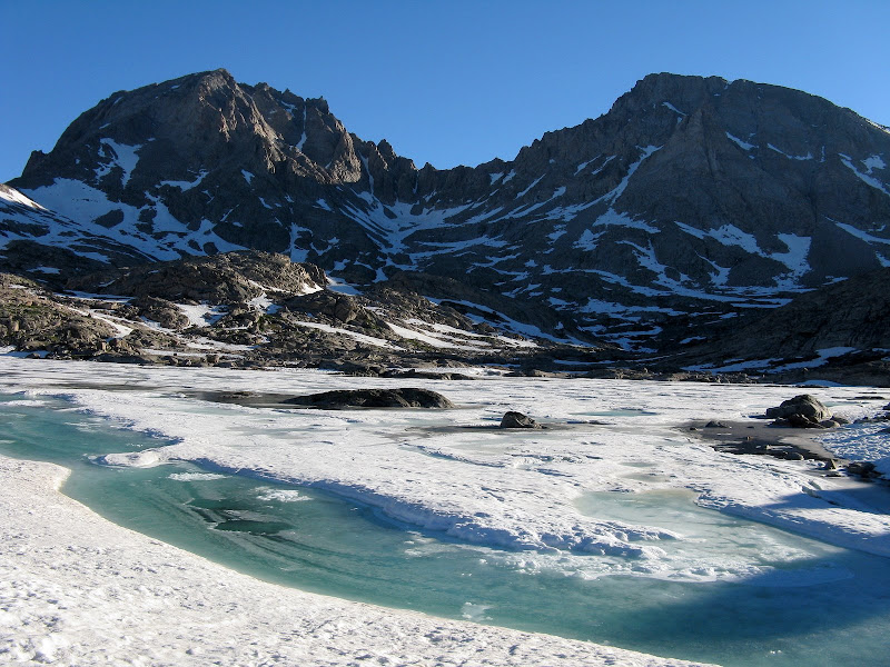
The traverse back across the glacier was the worst part of the day for me as I started to bonk. I made the mistake of going sans crampons since the glacier was low angle, but the uneven surface of the glacier made footing tough. At least the views more than made up for the pain, as we were amazed by a 40 foot moat at the edge of the glacier. I was glad to finally be off the rope, and we refueled for the slog back up to the pass. The food really helped me, and I felt much better the rest of the way up. We staggered back up to the pass at around 5:30. Only a little over 5 miles to go!
2 guys were camping at the pass positioned for a summit bid the next day. We gave them some beta and wished them good luck. Evening shadows were already starting to firm up the snow on the south side of the pass, so John and I opted to walk down with crampons while Dwight glissaded. About halfway down, the snow softened up and I took my crampons off for a nice glissade.
We all had renewed energy at this point knowing that the day’s difficulties were behind us, but the long day would soon catch up to us. The walk past the vast Titcomb Lakes seemed to take forever as we were now seemingly walking in slow-mo. Dusk descended on us, but the moon lit up the rocks and lakes enough that we could continue on sans headlamps. Everything started to look the same as we drew closer to camp. Lakes appeared that seemingly were not there on the way up. I think I started going delirious hoping to see camp soon. My batteries were long gone on my GPS and I was too lazy to look for spares. Dwight replaced his and announced we had ½ mile to go! 15 minutes later he said the GPS was out of whack and we still had 4/10ths to go. That was the longest stretch of my hiking career.
The terrain finally became familiar and camp appeared. I dove into my tent at 10:20pm, too tired to cook dinner. This was the longest dayhike for all of us and that includes the Grand Canyon Rim-Rim-Rim! Dwight and I agreed that Gannett ranked right up there with Rainier as the toughest summit day we have done physically speaking.
Day 4-Rest Day
Tue, July 15
Rest Day for me
Fremont Peak (13745') for Dwight and John
I pretty much resigned myself to sleeping in and passing on Fremont, which I later regretted. Dwight and John reported a fine class 3 scramble up the s.w. ridge on solid rock while I got some good rest until the tent got too hot. I couldn’t do much outside because the mosquitoes were attacking. I salvaged the day by climbing a nearby bump north of camp that offered some nice, slabby scrambling and killer views sans mosquitoes.
Day 5-Pack Out to Elkhart Park
Wed, July 16
Pack Out to Elkhart Park
13.1 miles, 1700’ gain
6.5 hrs
The pack out was a killer and the mosquitoes came to hammer us today. I must have a tasty blood type, because they seem to hover around me more. We left campat 6:30am to at least have a couple hours when they were not so aggressive. We briefly went up the wrong drainage leaving Island Lake that cost us about 300’ of vertical, but otherwise the pack out was uneventful.

I think the mosquitoes were more aggressive since it was much easier to pick up our scent after 5 days with no shower! The lakes had receded a good 4 feet since our afternoon hike in on Sat, so we were able to keep our boots dry. I quickly dreaded going uphill because the slower you went the more the mosquitoes hammered you! It seemed like we were going more uphill than down on the return until finally getting back to Photographer’s Point, and it was mostly downhill from there.
John commented that he was experiencing some tunnel vision near the end, as the hike seemed to never end. We began to see more and more dayhikers and knew that civilization was near. We finally made it back to the trailhead at 1pm and promptly hosed off all of the sweat, deet, and sunscreen from 5 days in the wilderness. The Wind River range is truly a special place, an area that cannot be matched in Colorado with its rugged peaks, vast lakes, and endless glaciers. Thanks John and Dwight for joining me on this most excellent adventure!


Comments
Post a Comment