
|
|
Mountain/Rock |
|---|---|
|
|
Hiking |
|
|
Overview
It wasn't until got home that I realized why Gold Ridge probably got it's name, there were gold flaked rocks everywhere. Where is Gold Ridge? Hiding behind Bountiful Peak. Gold Ridge is a 2 mile hike along a ridge with superb views east to the Uintas as well as the back side of the northern Wasatch peaks. An ATV trail goes the entire length to within 5 minutes of the summit so this makes for an excellent trip with kids.
Getting There
Going north on I-15, take the Farmington exit #322. Take a right at the Y on the exit ramp. The exit will put you onto 200 West. Follow it to the first stop sign and turn right. Proceed east (crossing Main Street) to 100 East. Turn left. Follow 100 East going north and it turns into Farmington Canyon Road. Drive up the canyon on a nice graded dirt road until you reach the top of the ridge. There you find a large snow shed. Continuing on would take you up to Frances Peak and the giant white balls. In the large dirt area just before the snow shed, make a sharp right and right again. A high clearance road goes a mile or so from here to the trailhead. Park if you can't make it. The road contours around a highpoint but soon reaches a saddle where the trailhead is located. Another road hits this location as well from Farmington Flats, but I did not try that route (shown as well on map).
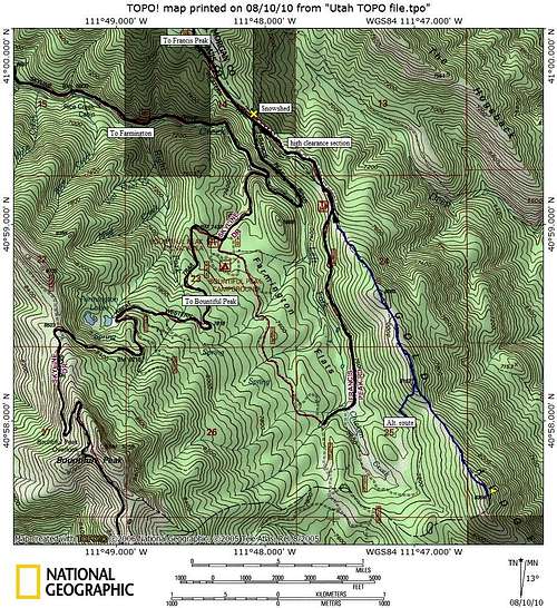 Gold Ridge Map
Farmington Canyon Road

Farmington Canyon
Red Tape
None
Trailhead

Francis Peak from trailhead
Route
The ATV trail starts out fairly steep and rocky. This isn't the best section but the majority of the climbing gets done this way as it climbs through forests and openings to a false summit at point 8085. From this point, you can see both another false summit and the true summit in the distance. The trail also improves a bit with fewer rocks but the rest of the route is in the sun. At the second false summit, you'll encounter a ATV route down towards Farmington Flats. After dropping off the second false summit around 200 feet, you'll finally climb the highpoint, an easy 400 foot climb (something I did carrying my 3 and 5 year old)! The ATV trail ends at the summit rocks. Look for a hiker trail on the east side of the rocks to the top. Once there, you'll see the highest point is a 3 minute walk from what you thought was the summit.
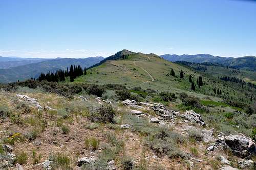
First view of summit
Views

Looking South

Bountiful Peak

Looking North

Durst Mountain
External Links